Self-guided Sightseeing Tour #2 in Melbourne, Australia
Legend
Guided Free Walking Tours
Book free guided walking tours in Melbourne.
Guided Sightseeing Tours
Book guided sightseeing tours and activities in Melbourne.
Tour Facts
5.1 km
121 m
Experience Melbourne in Australia in a whole new way with our free self-guided sightseeing tour. This site not only offers you practical information and insider tips, but also a rich variety of activities and sights you shouldn't miss. Whether you love art and culture, want to explore historical sites or simply want to experience the vibrant atmosphere of a lively city - you'll find everything you need for your personal adventure here.
Activities in MelbourneIndividual Sights in MelbourneSight 1: Yarra Park
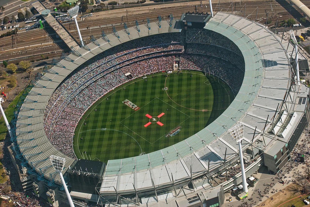
Yarra Park is a public park that is part of the Melbourne Sports and Entertainment Precinct, a sporting precinct in Victoria, Australia. Located in Yarra Park is the Melbourne Cricket Ground (MCG) and numerous sporting fields and ovals, including the associated sporting complexes of Melbourne and Olympic Parks. The park and sporting facilities are located in the inner-suburb of East Melbourne. In the late 1850s, many of the earliest games of Australian rules football were played at Yarra Park, which was known at the time as the Richmond Paddock.
Sight 2: Fitzroy Gardens
Get Ticket*
The Fitzroy Gardens are 26 hectares located on the southeastern edge of the Melbourne central business district in East Melbourne, Victoria, Australia. The gardens are bounded by Clarendon Street, Albert Street, Lansdowne Street, and Wellington Parade with the Treasury Gardens across Lansdowne street to the west.
Sight 3: Cooks' Cottage

Cooks' Cottage, also known as Captain Cook's Cottage, is located in the Fitzroy Gardens, Melbourne, Australia. The cottage was constructed in 1755 in the English village of Great Ayton, North Yorkshire, by the parents of Captain James Cook, James and Grace Cook, and was brought to Melbourne in 1934 by the Australian philanthropist Sir Russell Grimwade. It is a point of conjecture among historians whether James Cook, the famous navigator, ever lived in the house, but almost certainly he visited his parents at the house.
Sight 4: Treasury Gardens
Get Ticket*
The Treasury Gardens consist of 5.8 hectares on the south-eastern side of the Melbourne central business district, East Melbourne, Victoria, Australia. The gardens are bounded by Wellington Parade, Spring Street, Treasury Place, and by the Fitzroy Gardens across Lansdowne street to the west. They form part of a network of city gardens including Fitzroy Gardens, Carlton Gardens, Flagstaff Gardens and Kings Domain. The gardens are listed on the Australian National Heritage List and the Victorian Heritage Register for their historical, archaeological, social, "aesthetic and scientific (horticultural) importance for its outstanding nineteenth century design, path layout and planting".
Sight 5: Hon. George Higinbotham

George Higinbotham was a politician and was a Chief Justice of the Supreme Court of Victoria, which is the highest ranking court in the Australian colony, later state, of Victoria.
Sight 6: National Trust of Australia (Victoria)
The National Trust of Australia (Victoria) is a community-based, non-government organisation committed to promoting and conserving Australia's indigenous, natural and historic heritage places of cultural significance in Victoria. It was founded in 1956.
Wikipedia: National Trust of Australia (Victoria) (EN), Website
Sight 7: Saint Patrick's Cathedral

The Cathedral Church and Minor Basilica of Saint Patrick is the cathedral church of the Roman Catholic Archdiocese of Melbourne in Victoria, Australia, and seat of its archbishop, currently Peter Comensoli.
Sight 8: Princess Theatre
Get Ticket*
The Princess Theatre, originally Princess's Theatre, is a 1452-seat theatre in Melbourne, Victoria, Australia. Established in 1854 and rebuilt in 1886 to a design by noted Melbourne architect William Pitt, it is the oldest surviving entertainment site on mainland Australia. Built in an elaborate Second Empire style, it reflects the opulence of the "Marvellous Melbourne" boom period, and had a number of innovative features, including state of the art electric stage lighting and the world's first sliding ceiling, which was rolled back on warm nights to give the effect of an open-air theatre.
Sight 9: Greek Precinct
The Greek Precinct, Melbourne in Victoria, Australia, is a Greek cultural area centred on the eastern end of Lonsdale Street in the Melbourne city centre. The area runs adjacent to Melbourne Chinatown on Little Bourke Street.
Sight 10: Scots Church

The Scots' Church is a Presbyterian church in Collins Street, Melbourne, Victoria, Australia. Services are held at 11 am (traditional) and 5pm (contemporary). It is a reformed protestant church. It was the first Presbyterian church to be built in the Port Phillip District, and serves as a congregation of the Presbyterian Church of Australia. Its building was described as "an icon for well over a hundred years".
Sight 11: Saint Michaels Uniting Church

St Michael's Uniting Church is a Uniting church located on Collins Street in central Melbourne, Victoria, Australia. Originally the Collins Street Independent Church, a Congregational Union of Australia church, St Michael's has become well-known as a centre of liberal theology and political radicalism under its recent Minister, Dr Francis Macnab (1971–2016). In 2020, the church appointed a new Minister, Rev Dr Margaret Mayman.
Wikipedia: St Michael's Uniting Church, Melbourne (EN), Website
Sight 12: Bourke Street Mall

Bourke Street is one of the main streets in the Melbourne central business district and a core feature of the Hoddle Grid. It was traditionally the entertainment hub of inner-city Melbourne, and is now also a popular tourist destination and tram thoroughfare.
Sight 13: Coop's Shot Tower
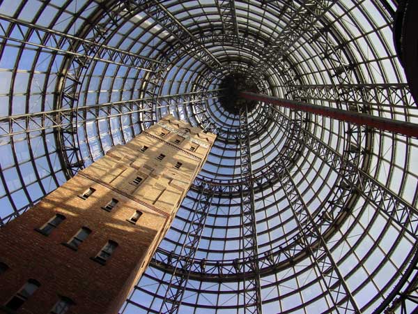
Coop's Shot Tower is a shot tower located in the heart of the Melbourne CBD, Australia. It was completed in 1889 and is 50 metres (160 ft) high. The historic building was saved from demolition in 1973 and was incorporated into Melbourne Central complex in 1991 underneath an 84 m-high (276 ft) conical glass roof.
Share
How likely are you to recommend us?
Disclaimer Please be aware of your surroundings and do not enter private property. We are not liable for any damages that occur during the tours.
GPX-Download For navigation apps and GPS devices you can download the tour as a GPX file.