38 Sights in Melbourne, Australia (with Map and Images)
Legend
Premium Sights
Book tickets, guided tours and activities in Melbourne.
Guided Free Walking Tours
Book free guided walking tours in Melbourne.
Welcome to your journey through the most beautiful sights in Melbourne, Australia! Whether you want to discover the city's historical treasures or experience its modern highlights, you'll find everything your heart desires here. Be inspired by our selection and plan your unforgettable adventure in Melbourne. Dive into the diversity of this fascinating city and discover everything it has to offer.
Sightseeing Tours in MelbourneActivities in Melbourne
The Shrine of Remembrance is a war memorial in Melbourne, Victoria, Australia, located in Kings Domain on St Kilda Road. It was built to honour the men and women of Victoria who served in World War I, but now functions as a memorial to all Australians who have served in any war. It is a site of annual observances for Anzac Day and Remembrance Day, and is one of the largest war memorials in Australia.

Federation Square is a venue for arts, culture and public events on the edge of the Melbourne central business district. It covers an area of 3.2 ha at the intersection of Flinders and Swanston Streets built above busy railway lines and across the road from Flinders Street station. It incorporates major cultural institutions such as the Ian Potter Centre, Australian Centre for the Moving Image (ACMI) and the Koorie Heritage Trust as well as cafes and bars in a series of buildings centred around a large paved square, and a glass walled atrium.

Birrarung Marr is an inner-city park between the central business district in Melbourne, Victoria, Australia and the Yarra River. It was opened in 2002. The name refers to the bank of Birrarung, the 'river of mists', in the Woiwurrung language of the Wurundjeri people, the Indigenous inhabitants at the time of European colonisation of the Melbourne area.

Hamer Hall, formerly the Melbourne Concert Hall, is an Australian concert hall. The 2,466-seat hall, the largest indoor venue at the Arts Centre Melbourne, is mostly used for orchestral and contemporary music performances. It was designed by Roy Grounds as part of the cultural centre which comprised the National Gallery of Victoria and the Arts Centre Melbourne. It was opened as the Melbourne Concert Hall in 1982 and was renamed Hamer Hall in honour of Sir Rupert Hamer shortly after his death in 2004.

The Princess Theatre, originally Princess's Theatre, is a 1452-seat theatre in Melbourne, Victoria, Australia. Established in 1854 and rebuilt in 1886 to a design by noted Melbourne architect William Pitt, it is the oldest surviving entertainment site on mainland Australia. Built in an elaborate Second Empire style, it reflects the opulence of the "Marvellous Melbourne" boom period, and had a number of innovative features, including state of the art electric stage lighting and the world's first sliding ceiling, which was rolled back on warm nights to give the effect of an open-air theatre.

The Old Melbourne Gaol is a former jail and current museum on Russell Street, in Melbourne, Victoria, Australia. It consists of a bluestone building and courtyard, and is located next to the old City Police Watch House and City Courts buildings, and opposite the Russell Street Police Headquarters. It was first constructed starting in 1839, and during its operation as a prison between 1845 and 1924, it held and executed some of Australia's most notorious criminals, including bushranger Ned Kelly and serial killer Frederick Bailey Deeming. In total, 133 people were executed by hanging. Though it was used briefly during World War II, it formally ceased operating as a prison in 1924; with parts of the jail being incorporated into the RMIT University, and the rest becoming a museum.

Sea Life Melbourne Aquarium is a Southern Ocean and Antarctic aquarium in central Melbourne, Australia. It is located on the banks of the Yarra River beside and under the Flinders Street Viaduct and the King Street Bridge. The attraction is a Sea Life Centre owned by Merlin Entertainments.

Melbourne Town Hall, often referred to as simply Town Hall, is the administrative seat of the local municipality of the City of Melbourne and the primary offices of the Lord Mayor and city councillors of Melbourne. Located on the northeast corner of Swanston and Collins street in the central business district of Melbourne, Victoria, Australia, the building was completed in 1887 and heritage listed on the Victorian Heritage Register in 1974. The building is frequently used for art and cultural events such as concerts, festivals, theatrical plays and exhibitions.

The City Baths, located at 420 Swanston Street, Melbourne, Victoria, Australia, opened in 1904 as public baths, with swimming pools and bathing facilities. Extensively renovated in the early 1980s, it is now considered one of Melbourne's most architecturally and historically significant buildings.

The Royal Exhibition Building is a UNESCO World Heritage-listed building in Melbourne, Victoria, Australia, built in 1879–1880 as part of the international exhibition movement, which presented over 50 exhibitions between 1851 and 1915 around the globe. The building sits on approximately 26 hectares, is 150 metres (490 ft) long and is surrounded by four city streets. It is situated at 9 Nicholson Street in the Carlton Gardens, flanked by Victoria, Carlton and Rathdowne Streets, at the north-eastern edge of the central business district. It was built to host the Melbourne International Exhibition in 1880–81, and then hosted the even larger Centennial International Exhibition in 1888. It was then chosen as the site for the Federation of the Commonwealth of Australia in 1901. The building is representative of the financial wealth and pride that the city of Melbourne and state of Victoria had in the 1870s. Throughout the 20th century smaller sections and wings of the building were subject to demolition and fire; however, the main building, known as the Great Hall, survived.

The Block Arcade is a historic shopping arcade in the central business district of Melbourne, Victoria, Australia. Constructed between 1891 and 1893, it is considered one of the late Victorian era's finest shopping arcades and ranks among Melbourne's most popular tourist attractions.

The Treasury Gardens consist of 5.8 hectares on the south-eastern side of the Melbourne central business district, East Melbourne, Victoria, Australia. The gardens are bounded by Wellington Parade, Spring Street, Treasury Place, and by the Fitzroy Gardens across Lansdowne street to the west. They form part of a network of city gardens including Fitzroy Gardens, Carlton Gardens, Flagstaff Gardens and Kings Domain. The gardens are listed on the Australian National Heritage List and the Victorian Heritage Register for their historical, archaeological, social, "aesthetic and scientific (horticultural) importance for its outstanding nineteenth century design, path layout and planting".

The Fitzroy Gardens are 26 hectares located on the southeastern edge of the Melbourne central business district in East Melbourne, Victoria, Australia. The gardens are bounded by Clarendon Street, Albert Street, Lansdowne Street, and Wellington Parade with the Treasury Gardens across Lansdowne street to the west.
14. Fiona & Sidney Myer Gallery

The University of Melbourne is a public research university located in Melbourne, Australia. Founded in 1853, it is Australia's second oldest university and the oldest in Victoria. Its main campus is located in Parkville, an inner suburb north of Melbourne's central business district, with several other campuses located across Victoria.
15. Saint Paul's Cathedral

St Paul's Cathedral is an Anglican cathedral in Melbourne, Australia. It is the cathedral church of the Diocese of Melbourne and the seat of the Archbishop of Melbourne, who is also the metropolitan archbishop of the Province of Victoria.
16. Crown Melbourne

Crown Melbourne is an integrated resort consisting of a casino and hotel located on the south bank of the Yarra River, in Melbourne, Australia. Crown Melbourne is a subsidiary of Crown Resorts, and was the first casino of the now-international Crown brand.
17. Melbourne Zoological Gardens
Melbourne Zoo is a zoo in Melbourne, Australia. It is located within Royal Park in Parkville, approximately 4 kilometres (2.5 mi) north of the centre of Melbourne. It is the primary zoo serving Melbourne. As of 2021, the zoo contains 3742 animals comprising 243 species, from Australia and around the world. The zoo is accessible via Royal Park station on the Upfield railway line, and is also accessible via tram routes 58 and 19, as well as by bicycle on the Capital City Trail. Bicycles are not allowed inside the zoo itself.
18. Saint Patrick's Cathedral

The Cathedral Church and Minor Basilica of Saint Patrick is the cathedral church of the Roman Catholic Archdiocese of Melbourne in Victoria, Australia, and seat of its archbishop, currently Peter Comensoli.
19. Scots Church

The Scots' Church is a Presbyterian church in Collins Street, Melbourne, Victoria, Australia. Services are held at 11 am (traditional) and 5pm (contemporary). It is a reformed protestant church. It was the first Presbyterian church to be built in the Port Phillip District, and serves as a congregation of the Presbyterian Church of Australia. Its building was described as "an icon for well over a hundred years".
20. Saint Michaels Uniting Church

St Michael's Uniting Church is a Uniting church located on Collins Street in central Melbourne, Victoria, Australia. Originally the Collins Street Independent Church, a Congregational Union of Australia church, St Michael's has become well-known as a centre of liberal theology and political radicalism under its recent Minister, Dr Francis Macnab (1971–2016). In 2020, the church appointed a new Minister, Rev Dr Margaret Mayman.
Wikipedia: St Michael's Uniting Church, Melbourne (EN), Website
21. Cooks' Cottage

Cooks' Cottage, also known as Captain Cook's Cottage, is located in the Fitzroy Gardens, Melbourne, Australia. The cottage was constructed in 1755 in the English village of Great Ayton, North Yorkshire, by the parents of Captain James Cook, James and Grace Cook, and was brought to Melbourne in 1934 by the Australian philanthropist Sir Russell Grimwade. It is a point of conjecture among historians whether James Cook, the famous navigator, ever lived in the house, but almost certainly he visited his parents at the house.
22. Melbourne City Square

The City Square was a public plaza located in the Central Business District (CBD) of Melbourne, Victoria, Australia. The site was bounded by Swanston Street, Collins Street, Flinders Lane and the Westin Hotel. The historic landmarks of Melbourne Town Hall and St Paul’s Cathedral were across the streets to the north and south respectively.
23. Kings Domain

Kings Domain is an area of parklands in Melbourne, Victoria, Australia. It surrounds Government House Reserve, the home of the governors of Victoria, the Sidney Myer Music Bowl, and the Shrine Reserve incorporating the Shrine of Remembrance.
24. Collins Street Baptist Church

Collins Street Baptist Church is a Baptist church, located at 174 Collins Street, Melbourne, Victoria, Australia. The church is affiliated with the Australian Baptist Ministries. Founded in 1843, it is the oldest Baptist church in Victoria and the oldest continuous Baptist church in Australia.
25. Coop's Shot Tower
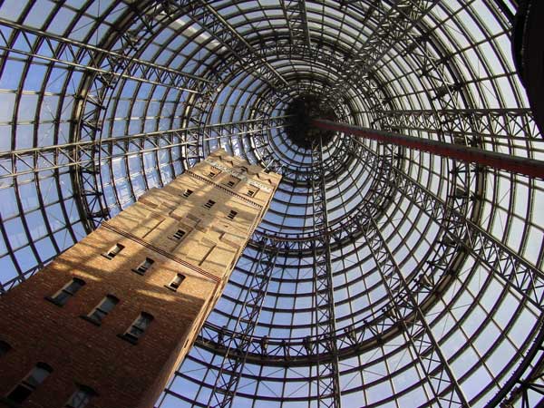
Coop's Shot Tower is a shot tower located in the heart of the Melbourne CBD, Australia. It was completed in 1889 and is 50 metres (160 ft) high. The historic building was saved from demolition in 1973 and was incorporated into Melbourne Central complex in 1991 underneath an 84 m-high (276 ft) conical glass roof.
26. Malthouse Theatre

Malthouse Theatre is the resident theatre company of The Malthouse building in Southbank, part of the Melbourne Arts Precinct. In the 1980s it was known as the Playbox Theatre Company and was housed in the Playbox Theatre in Melbourne's CBD. It is a heritage-listed building which contains three theatres: Merlyn Theatre, Beckett Theatre, and The Tower.
27. Queen Victoria Gardens

The Queen Victoria Gardens are Melbourne's memorial to Queen Victoria. Located on 4.8 hectares opposite the Victorian Arts Centre and National Gallery of Victoria, bounded by St Kilda Road, Alexandra Avenue and Linlithgow Avenue.
28. Vault (The Yellow Peril)

Vault is a public sculpture located in Southbank, Melbourne, Victoria, Australia. The work of sculptor Ron Robertson-Swann, Vault is an abstract, minimalist sculpture built of large thick flat polygonal sheets of prefabricated steel, assembled in a way that suggests dynamic movement. It is painted yellow.
29. Alexandra Gardens

The Alexandra Gardens are located on the south bank of the Yarra River, opposite Federation Square and the Melbourne Central Business District, in Victoria, Australia. The Gardens are bounded by the Yarra River to the north, Princes and Swan street bridges, with Queen Victoria Gardens and Kings Domain across Alexandra Avenue to the south. The gardens are part of the Domain parklands which stretch to the Royal Botanic Gardens and were first laid out in 1901, under the direction of Carlo Catani, Chief Engineer of the Public Works Department. The Alexandra Gardens were named in honour of Alexandra of Denmark, in the year her reign as Queen Consort of the United Kingdom and the British Dominions and Empress consort of India began. The Alexandra Gardens are listed on the Victorian Heritage Register due to their historical and archaeological significance.
30. Batman's Hill

Batman's Hill in Melbourne, Australia was named for the Vandemonian adventurer and grazier John Batman. Now removed, the 18-metre high (59 ft) hill was located to the south of today's Collins Street and Southern Cross railway station, and is the site of a steel marker the same height as the original hill.
31. Yarra Park
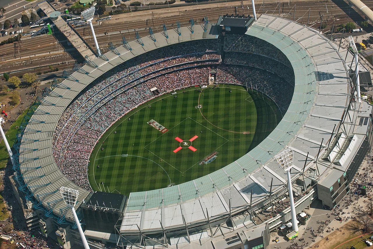
Yarra Park is a public park that is part of the Melbourne Sports and Entertainment Precinct, a sporting precinct in Victoria, Australia. Located in Yarra Park is the Melbourne Cricket Ground (MCG) and numerous sporting fields and ovals, including the associated sporting complexes of Melbourne and Olympic Parks. The park and sporting facilities are located in the inner-suburb of East Melbourne. In the late 1850s, many of the earliest games of Australian rules football were played at Yarra Park, which was known at the time as the Richmond Paddock.
32. Melbourne City Synagogue

The East Melbourne Hebrew Congregation, also known as East Melbourne Shule, East Melbourne Synagogue, Melbourne City Synagogue or City of Melbourne Synagogue is an Orthodox Jewish congregation and historically significant synagogue, located in East Melbourne, Victoria, Australia. The synagogue, consecrated in 1877, is the oldest in Melbourne.
33. Fawkner Park

Fawkner Park is a popular park in Melbourne's South Yarra and part of the City of Melbourne. It provides recreational areas for teams playing cricket, softball, soccer, Australian rules football, tennis, quadball and rugby.
34. Austral House

The Austral Building is a broadly English Queen Anne revival building located at 115-119 Collins Street, Melbourne, Australia. It was designed by noted Melbourne architect, Nahum Barnet, built in 1890, and housed noted literary and artistic tenants until well into the 20th century.
35. Newburn Flats

Newburn Flats is an apartment building located at 30 Queens Road, Melbourne. It is considered one of the first examples of European Modernist ideals applied to multi-unit residences in Australia. It was designed by the firm Romberg & Shaw in 1939 and completed in 1941.
36. MPavillion

MPavilion is a temporary pavilion in Queen Victoria Gardens, Melbourne, erected annually since 2014. The event is sponsored by philanthropist Naomi Milgrom. Initially the project was planned for four years, but later it was extended by another two, until 2019, and then another three years to 2023. No pavilion was constructed in 2020 due to the COVID-19 pandemic. The pavilions are used for various art events, after which each pavilion is gifted to the city or institution and moved to a permanent location.
37. J.J. Holland Park

J.J. Holland Park is a large multi-use park in the Melbourne suburb of Kensington. It is named after John Joseph Holland (1877–1955), who was the Member of the Legislative Assembly for Flemington for over 30 years from 1925.
38. Bourke Street Mall

Bourke Street is one of the main streets in the Melbourne central business district and a core feature of the Hoddle Grid. It was traditionally the entertainment hub of inner-city Melbourne, and is now also a popular tourist destination and tram thoroughfare.
Share
How likely are you to recommend us?
Disclaimer Please be aware of your surroundings and do not enter private property. We are not liable for any damages that occur during the tours.