Self-guided Sightseeing Tour #1 in Santa Barbara, United States
Legend
Tour Facts
1.8 km
20 m
Experience Santa Barbara in United States in a whole new way with our free self-guided sightseeing tour. This site not only offers you practical information and insider tips, but also a rich variety of activities and sights you shouldn't miss. Whether you love art and culture, want to explore historical sites or simply want to experience the vibrant atmosphere of a lively city - you'll find everything you need for your personal adventure here.
Individual Sights in Santa BarbaraSight 1: Casa Dolores
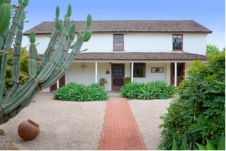
Casa Dolores, Center for the Study of the Popular Arts of Mexico is an art museum located on 1023 Bath Street in Santa Barbara, California.
Sight 2: Santa Barbara Museum of Art

The Santa Barbara Museum of Art (SBMA) is an art museum located in downtown Santa Barbara, California.
Sight 3: Casa de la Guerra

The Casa de la Guerra was the residence of the fifth commandant of the Presidio de Santa Barbara, José de la Guerra y Noriega, founder of the Guerra family of California from 1828 until his death in 1858. Descendants of José lived in the home until 1943. The site is currently owned and operated by the Santa Barbara Trust for Historic Preservation as a historic house museum. The address is 15 East De la Guerra Street, Santa Barbara, California.
Sight 4: Santa Barbara Historical Museum

The Santa Barbara Historical Museum is located in Santa Barbara, California, U.S. It features relics from Chumash, Spanish, Mexican, Yankee, and Chinese cultures, including artifacts, photographs, furnishings and textiles, dating as far back as the 15th century.
Sight 5: Presidio of Santa Barbara State Historic Park

El Presidio Real de Santa Bárbara, also known as the Royal Presidio of Santa Barbara, is a former military installation in Santa Barbara, California, United States. The presidio was built by Spain in 1782, with the mission of defending the Second Military District in California. In modern times, the Presidio serves as a significant tourist attraction, museum and an active archaeological site as part of El Presidio de Santa Barbara State Historic Park.
Share
How likely are you to recommend us?
Disclaimer Please be aware of your surroundings and do not enter private property. We are not liable for any damages that occur during the tours.
GPX-Download For navigation apps and GPS devices you can download the tour as a GPX file.