Self-guided Sightseeing Tour #9 in New York, United States
Legend
Guided Free Walking Tours
Book free guided walking tours in New York.
Guided Sightseeing Tours
Book guided sightseeing tours and activities in New York.
Tour Facts
11.1 km
437 m
Experience New York in United States in a whole new way with our free self-guided sightseeing tour. This site not only offers you practical information and insider tips, but also a rich variety of activities and sights you shouldn't miss. Whether you love art and culture, want to explore historical sites or simply want to experience the vibrant atmosphere of a lively city - you'll find everything you need for your personal adventure here.
Individual Sights in New YorkSight 1: Seward Park

- You are free: to share – to copy, distribute and transmit the work to remix – to adapt the work
- Under the following conditions: attribution – You must give appropriate credit, provide a link to the license, and indicate if changes were made. You may do so in any reasonable manner, but not in any way that suggests the licensor endorses you or your use. share alike – If you remix, transform, or build upon the material, you must distribute your contributions under the same or compatible license as the original.
Seward Park is a public park and playground in the Lower East Side neighborhood of Manhattan, New York City. Located north of East Broadway and east of Essex Street, it is 3.046 acres (12,330 m2) in size and is the first municipally built playground in the United States.
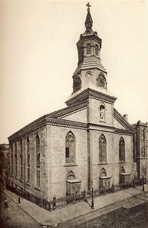
Sight 2: St. Teresa's Church

The Church of St. Teresa is a Roman Catholic parish located at 16-18 Rutgers Street on the corner of Henry Street in the Lower East Side neighborhood of Manhattan, New York City. The parish is under the authority of the Archdiocese of New York. The church building was constructed in 1841-42 as the Rutgers Presbyterian Church erected in the Gothic Revival style on a plot of ground donated by Colonel Henry Rutgers, and it is said to have the oldest public clock in New York City. The church was taken over by St. Teresa's Parish in 1863, three years after it was founded.
Sight 3: Museum at Eldridge Street

The Eldridge Street Synagogue is an Orthodox Jewish synagogue at 12–16 Eldridge Street in the Chinatown and Lower East Side neighborhoods of Manhattan in New York City. Built in 1887 for Congregation Kahal Adath Jeshurun, the synagogue is one of the first erected in the U.S. by Eastern European Jews. The congregation, officially known as Kahal Adath Jeshurun with Anshe Lubz, still owns the synagogue and hosts weekly services there in the 21st century. The Museum at Eldridge Street, founded in 1986 as the Eldridge Street Project, also occupies the synagogue under a long-term lease. The building is a National Historic Landmark and a New York City designated landmark.
Wikipedia: Eldridge Street Synagogue (EN), Website, Opening Hours
Sight 4: First Chinese Presbyterian Church

The Sea and Land Church is located at 61 Henry Street and Market Street in the Chinatown and Two Bridges neighborhoods of Manhattan in New York City. It was built in 1819 of Manhattan schist, and added to the National Register of Historic Places on April 9, 1980. The structure is one of the three Georgian Gothic Revival churches on the Lower East Side with the other ones being St. Augustine's Chapel and the Church of the Transfiguration. It is also the second oldest church building in New York City.
Sight 5: Mariners Temple

Mariner's Temple is a Baptist church at 3 Henry Street, in the Two Bridges section of Manhattan, New York City. It is a brownstone building with Ionic columns. It is affiliated with the American Baptist Churches USA.
Sight 6: St. James Church

St. James' Roman Catholic Church is located at 32 James Street between St. James Place and Madison Street in the Two Bridges neighborhood of Lower Manhattan, New York City. It is the second oldest Roman Catholic building in the city, built in 1835–1837 of fieldstone, with a pair of Doric columns flanking the entrance. While the neo-classical church is modeled on the published designs by Minard Lefever, and is sometimes attributed to him, there is no hard evidence of this being true. The building was once topped by a domed cupola.
Sight 7: Church of the Transfiguration
The Church of the Transfiguration is a Roman Catholic parish located at 25 Mott Street on the northwest corner of Mosco Street in the Chinatown neighborhood of Manhattan, New York City. The parish is under the authority of the Archdiocese of New York and is staffed by the Maryknoll order.
Wikipedia: Church of the Transfiguration, Roman Catholic (Manhattan) (EN)
Sight 8: Columbus Park

Columbus Park formerly known as Mulberry Bend Park, Five Points Park and Paradise Park, is a public park in Chinatown, Manhattan, in New York City that was built in 1897.
Sight 9: Triumph of the Human Spirit

Triumph of the Human Spirit is a 2000 black granite sculpture by Lorenzo Pace, installed at Manhattan's Foley Square, in the U.S. state of New York. According to the City of New York, the 50-foot (15 m), 300-ton, abstract monument is derived from the female antelope Chiwara forms of Bambaran art. The sculpture is sited near a rediscovered Colonial-era African Burial Ground, and its support structure alludes to the slave trade's Middle Passage. The work was commissioned by the New York City Government program Percent for Art.
Sight 10: 5 in 1

5 in 1 is a 35-foot-tall (11 m), 75,000-pound (34,000 kg) painted CorTen steel sculpture by Tony Rosenthal, installed at 1 Police Plaza in Lower Manhattan, New York. Commissioned by the government of New York City in 1971 at a cost of $80,000, it was created between 1973 and 1974, and installed on the brick paved pedestrian mall of 1 Police Plaza.
Sight 11: 41 Park Row

41 Park Row, also 147 Nassau Street and formerly the New York Times Building, is an office building in the Financial District of Manhattan in New York City, across from City Hall and the Civic Center. It occupies a plot abutting Nassau Street to the east, Spruce Street to the north, and Park Row to the west. The building, originally the headquarters of The New York Times, is the oldest surviving structure of Lower Manhattan's former "Newspaper Row" and has been owned by Pace University since 1951.
Sight 12: City Hall

The City Hall station, also known as City Hall Loop station, is a closed station on the IRT Lexington Avenue Line of the New York City Subway. It is located under City Hall Park, next to New York City Hall, in the Civic Center neighborhood of Manhattan in New York City. The station was constructed for the Interborough Rapid Transit Company (IRT) as the southern terminal of the city's first subway line, which was approved in 1900. Construction of the segment of the line that includes the City Hall station started on September 12 of the same year. The station opened on October 27, 1904, as one of the original 28 stations of the New York City Subway. As ridership grew, it was deemed infeasible to lengthen the original platform to accommodate ten-car trains. The station was closed on December 31, 1945, because of its proximity to the Brooklyn Bridge station.
Wikipedia: City Hall station (IRT Lexington Avenue Line) (EN)
Sight 13: Woolworth Building
The Woolworth Building is a 792-foot-tall (241 m) residential building and early skyscraper at 233 Broadway in the Tribeca neighborhood of Lower Manhattan in New York City, United States. Designed by Cass Gilbert, it was the tallest building in the world from 1913 to 1929, and it remains one of the nation's 100 tallest buildings as of 2024.
Sight 14: Saint Peter's Church

Saint Peter's Church/Our Lady of the Rosary is a Catholic church in the Financial District of Manhattan, New York City. The current building was constructed from 1836 to 1840 and was designed by John R. Haggerty and Thomas in the Greek Revival style, with six Ionic columns. The church opened February 25, 1838 with Archbishop John Hughes officiating.
Sight 15: Saint Paul's Chapel

St. Paul's Chapel is a chapel building of Trinity Church, an episcopal parish, located at 209 Broadway, between Fulton Street and Vesey Street, in Lower Manhattan, New York City. Built in 1766, it is the oldest surviving church building in Manhattan and one of the nation's most well renowned examples of Late Georgian church architecture.
Wikipedia: St. Paul's Chapel (EN), Website, Heritage Website
Sight 16: Corbin Building

The Corbin Building is a historic office building at the northeast corner of John Street and Broadway in the Financial District of Manhattan in New York City. It was built in 1888–1889 as a speculative development and was designed by Francis H. Kimball in the Romanesque Revival style with French Gothic detailing. The building was named for Austin Corbin, a president of the Long Island Rail Road who also founded several banks.
Sight 17: John Street Methodist Church

The John Street United Methodist Church – also known as Old John Street Methodist Episcopal Church – located at 44 John Street between Nassau and William Streets in the Financial District of Manhattan, New York City was built in 1841 in the Georgian style, with the design attributed to William Hurry and/or Philip Embury. The congregation is the oldest Methodist congregation in North America, founded on October 12, 1766 as the Wesleyan Society in America.
Sight 18: Church of Our Lady of Victory

The Church of Our Lady of Victory, also known as the War Memorial Church, is a Roman Catholic parish church in the Roman Catholic Archdiocese of New York, located at 60 William Street on the northeast corner of William Street and Pine Street in the Financial District of Manhattan, New York City. It was established in 1944, during World War II, by Cardinal Francis Spellman, Archbishop of New York and Apostolic Vicar for the U.S. Armed Forces from December 11, 1939, to December 2, 1967, at a time when "victory in the war was in sight but not yet assured." A quote from Cardinal Spellman greets worshipers at the front door: "This Holy Shrine is dedicated to Our Lady of Victory in Thanksgiving for Victory won by our valiant dead, our soldier’s blood, our country’s tears, shed to defend men’s rights and win back men’s hearts to God."
Sight 19: Museum of American Finance
The Museum of American Finance is an independent public museum dedicated to preserving, exhibiting and teaching about American finance and financial history. Located in the Financial District in Manhattan, New York City, it is an affiliate of the Smithsonian Institution. It is a tax-exempt 501(c)(3) organization chartered by the Board of Regents of the New York State Department of Education. With education at the core of its mission, it is an active national-level advocate on behalf of financial literacy.
Sight 20: Federal Hall National Memorial

Federal Hall is a memorial and historic site at 26 Wall Street in the Financial District of Manhattan in New York City. The current Greek Revival–style building, completed in 1842 as the Custom House, is owned by the United States federal government and operated by the National Park Service as a national memorial called the Federal Hall National Memorial. The memorial is named for an earlier Federal style building on this same site, completed in 1703 as City Hall, which the government of the newly independent United States used as its capital building and called Federal Hall during the 1780s.
Sight 21: Fearless Girl

Fearless Girl is a bronze sculpture by Kristen Visbal of a 4-foot high (1.2 m) girl standing in a self-confident pose. It is currently located in New York City on Broad Street across from the New York Stock Exchange Building in the Financial District of Manhattan.
Sight 22: New York Stock Exchange

The New York Stock Exchange Building is the headquarters of the New York Stock Exchange (NYSE), located in the Financial District of Lower Manhattan in New York City. It is composed of two connected structures occupying much of the city block bounded by Wall Street, Broad Street, New Street, and Exchange Place. The central section of the block contains the original structure at 18 Broad Street, designed in the Classical Revival style by George B. Post. The northern section contains a 23-story office annex at 11 Wall Street, designed by Trowbridge & Livingston in a similar style.
Sight 23: John Watts

An outdoor bronze sculpture depicting U.S. Congressman John Watts by George Edwin Bissell is installed in the Trinity Church Cemetery outside Manhattan's Trinity Church, in the U.S. state of New York. It was erected by Watt's grandson, John Watts de Peyster, in 1893.
Sight 24: Trinity Church
Trinity Church is a historic parish in the Episcopal Diocese of New York, whose church is located at 89 Broadway opposite Wall Street, in the Financial District of Lower Manhattan in New York City. Known for its centuries of history, prominent location, distinguished architecture and bountiful endowment, Trinity's congregation is said to be "high church", its activities based on the traditions of the Episcopal Church and the worldwide Anglican Communion in missionary outreach, and fellowship. In addition to its main church, Trinity parish maintains two chapels: St. Paul's Chapel, and the Chapel of St. Cornelius the Centurion on Governors Island. The Church of the Intercession, the Trinity Chapel Complex and many other of Manhattan's Episcopal congregations were once part of Trinity parish. Columbia University was founded on the church's grounds as King's College in 1754.
Wikipedia: Trinity Church (Manhattan) (EN), Website, Heritage Website
Sight 25: Zuccotti Park

Zuccotti Park is a 33,000-square-foot (3,100 m2) publicly accessible park in the Financial District of Lower Manhattan in New York City. It is located in a privately owned public space (POPS) controlled by Brookfield Properties and Goldman Sachs. Zuccotti Park is bounded by Broadway to the east, Liberty Street to the north, Trinity Place to the west, and Cedar Street to the south.
Sight 26: Joie de Vivre
Joie de Vivre is an outdoor sculpture by Mark di Suvero, located at Zuccotti Park in the Financial District of Lower Manhattan, New York City. The 70-foot sculpture, composed of "open-ended tetrahedrons", was installed by the intersection of Broadway and Cedar Street in June 2006 and was previously located at the Holland Tunnel rotary.
Sight 27: Double Check
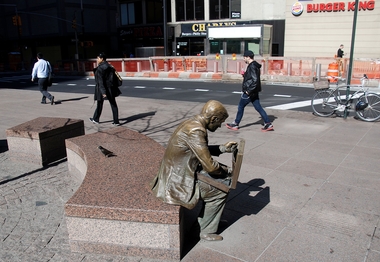
Double Check is a 1982 sculpture by John Seward Johnson II, located across from Zuccotti Park at the corner of Liberty Street and Broadway in Manhattan, New York City. The bronze sculpture portrays a well-dressed businessman sitting with his briefcase open, which are filled with office materials getting ready to enter an office building. The statue is notable for its association with the 9/11 attacks.
Sight 28: 9/11 Memorial & Museum
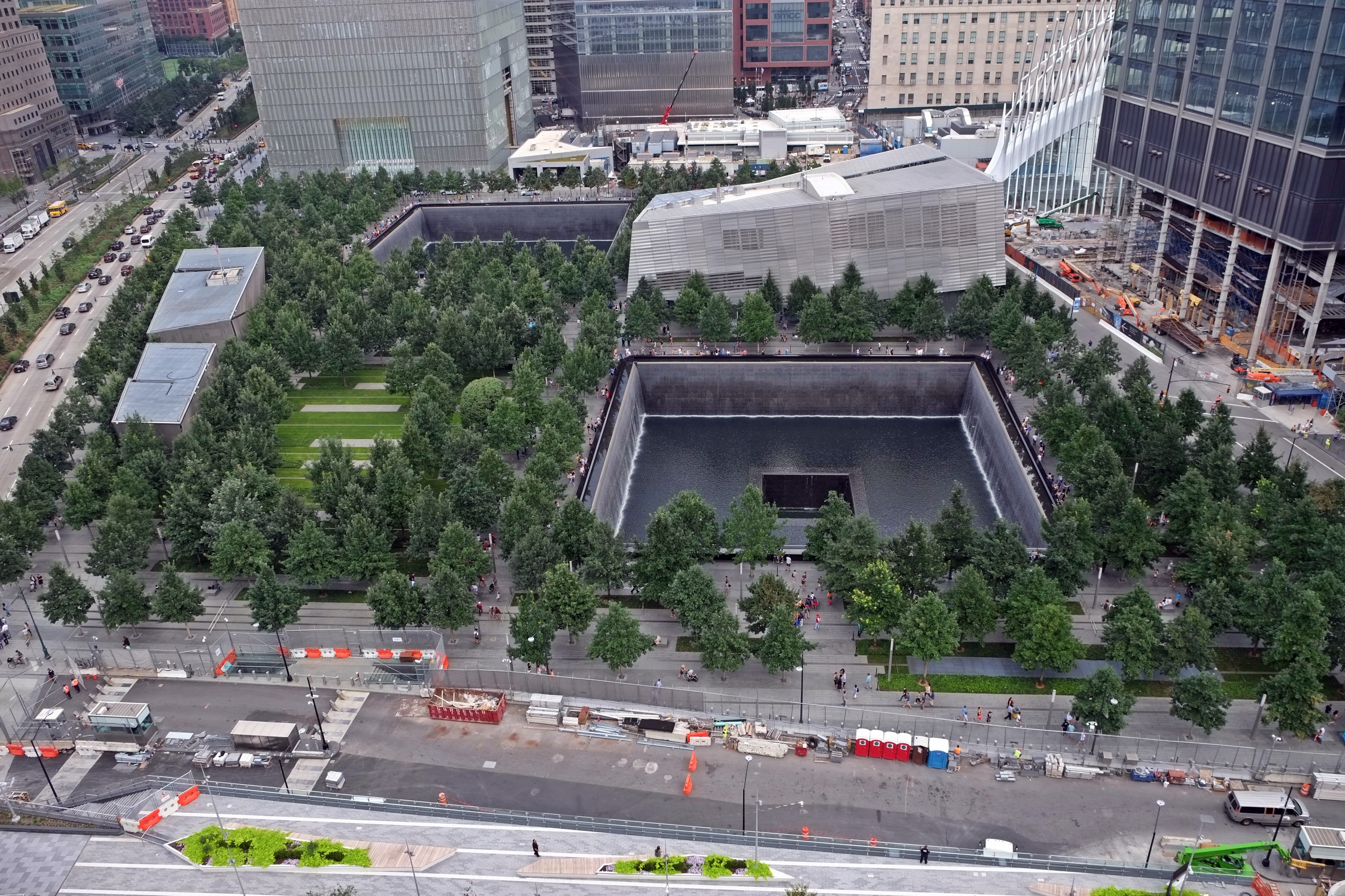
The National September 11 Memorial & Museum is a memorial and museum that are part of the World Trade Center complex, in New York City, created for remembering the September 11, 2001, attacks, which killed 2,977 people, and the 1993 World Trade Center bombing, which killed six. The memorial is located at the World Trade Center site, the former location of the Twin Towers that were destroyed during the September 11 attacks. It is operated by a non-profit institution whose mission is to raise funds to program and operate the memorial and museum at the World Trade Center site.
Wikipedia: National September 11 Memorial & Museum (EN), Website
Sight 29: Liberty Park

Liberty Park is a one-acre (0.40 ha) elevated public park at the World Trade Center in Manhattan, New York City, overlooking the National September 11 Memorial & Museum in Lower Manhattan. The park, which opened on June 29, 2016, is located above the World Trade Center's Vehicular Security Center. The St. Nicholas National Shrine is located within the park, as well as Fritz Koenig's The Sphere, the iconic sculpture salvaged from the World Trade Center site. Another statue, America's Response Monument, is also located in the park.
Sight 30: The Sphere

The Sphere is a monumental cast bronze sculpture by German artist Fritz Koenig (1924–2017).
Sight 31: America's Response Monument

America's Response Monument, subtitled De Oppresso Liber, is a life-and-a-half scale bronze statue in Liberty Park overlooking the National September 11 Memorial & Museum in New York City. Unofficially known as the Horse Soldier Statue, it is the first publicly accessible monument dedicated to the United States Army Special Forces. It was also the first monument near Ground Zero to recognize heroes of the September 11 terrorist attacks.
Sight 32: St. Nicholas Greek Orthodox Church

The St. Nicholas Greek Orthodox Church, officially the St. Nicholas Greek Orthodox Church and National Shrine, is a church and shrine in the World Trade Center in Lower Manhattan, New York City. It is administered by the Greek Orthodox Archdiocese of America and has been developed by the Port Authority of New York and New Jersey, based upon the design of Spanish architect Santiago Calatrava. The church was consecrated on July 4, 2022.
Wikipedia: St. Nicholas Greek Orthodox Church (Manhattan) (EN)
Sight 33: Elizabeth H. Berger Plaza

Elizabeth H. Berger Plaza is a public park in the Financial District of Manhattan, New York City. Formed by the triangular junction of Trinity Place, Greenwich Street, and Edgar Street. It faces the Manhattan exit ramp from the Brooklyn–Battery Tunnel. Formerly known as the Edgar Street Greenstreet, this park honors civic advocate Elizabeth H. Berger (1960–2013). In her role as president of the Downtown Alliance, she advocated for the fusion of two traffic triangles at this location into an expanded park. The park is located on the site of a former neighborhood known as Little Syria, a bustling immigrant community displaced by the construction of the tunnel in 1953.
Sight 34: Charging Bull
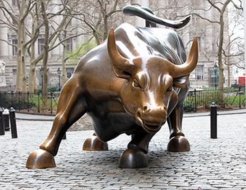
Charging Bull is a bronze sculpture that stands on Broadway just north of Bowling Green in the Financial District of Manhattan in New York City. The 7,100-pound (3,200 kg) bronze sculpture, standing 11 feet (3.4 m) tall and measuring 16 feet (4.9 m) long, depicts a bull, the symbol of financial optimism and prosperity. Charging Bull is a popular tourist destination that draws thousands of people a day, symbolizing Wall Street and the Financial District.
Sight 35: Bowling Green

Bowling Green is a small, historic, public park in the Financial District of Lower Manhattan, New York City, at the southern end and address origin of Broadway. Located in the 18th century next to the site of the original Dutch fort of New Amsterdam, it served as a public gathering place and under the English was designated as a park in 1733. It is the oldest public park in New York City and is surrounded by its original 18th-century cast iron fence. The park included an actual bowling green and a monumental equestrian statue of King George III prior to the American Revolutionary War. Pulled down during the revolution, the 4000-pound statue is said to have been melted for ammunition to fight the British.
Sight 36: Africa

Four Continents is the collective name of four sculptures by Daniel Chester French, installed outside the Alexander Hamilton U.S. Custom House at Bowling Green in Manhattan, New York City. French performed the commissions with associate Adolph A. Weinman.
Sight 37: International Mercantile Marine Company Building

1 Broadway is a 12-story office building in the Financial District of Manhattan, New York City. It is located at the intersection of Battery Place and Broadway, adjacent to Bowling Green to the east and the Battery to the south.
Sight 38: Skyscraper Museum

The Skyscraper Museum is an architecture museum located in Battery Park City, Manhattan, New York City and founded in 1996. As the name suggests, the museum focuses on high-rise buildings as "products of technology, objects of design, sites of construction, investments in real estate, and places of work and residence." The Skyscraper Museum also celebrates the architectural heritage of New York and the forces and people who created New York's skyline. Before moving to the current and permanent location in Battery Park City in 2004, the museum was a nomadic institution, holding pop-up exhibitions in four temporary donated spaces around Lower Manhattan since 1996.
Sight 39: Battery Park

The Battery, formerly known as Battery Park, is a 25-acre (10 ha) public park located at the southern tip of Manhattan Island in New York City facing New York Harbor. It is bounded by Battery Place on the north, with Bowling Green to the northeast, State Street on the east, New York Harbor to the south, and the Hudson River to the west. The park contains attractions such as an early 19th-century fort named Castle Clinton; multiple monuments; and the SeaGlass Carousel. The surrounding area, known as South Ferry, contains multiple ferry terminals, including the Staten Island Ferry's Whitehall Terminal; a boat launch to the Statue of Liberty National Monument ; and a boat launch to Governors Island.
Sight 40: New York Vietnam Veterans Memorial

Vietnam Veterans Plaza is an American memorial plaza in Manhattan, New York. It honors New York City citizens who served during the 20th-century Vietnam War.
Sight 41: The Queen Elizabeth II September 11th Garden

The Queen Elizabeth II September 11th Garden is located in Hanover Square in the Financial District of Lower Manhattan, New York City. It commemorates the Commonwealth of Nations member states' victims of the September 11 attacks on the World Trade Center. It was officially opened by Queen Elizabeth II on July 6, 2010, in a ceremony alongside her husband Prince Philip, Duke of Edinburgh, then-Mayor of New York City Michael Bloomberg, then-Governor of New York David Paterson, and then-Governor of New Jersey Chris Christie.
Wikipedia: Queen Elizabeth II September 11th Garden (EN), Website
Sight 42: New York Cocoa Exchange Building

1 Wall Street Court is a residential building in the Financial District of Manhattan in New York City, United States. The 15-story building, designed by Clinton and Russell in the Renaissance Revival style, was completed in 1904 at the intersection of Wall, Pearl, and Beaver Streets.
Sight 43: Wavertree

Wavertree is a historic iron-hulled sailing ship built in 1885. Now the largest wrought iron sailing vessel afloat, it is located at the South Street Seaport in New York City.
Sight 44: Ambrose

- You are free: to share – to copy, distribute and transmit the work to remix – to adapt the work
- Under the following conditions: attribution – You must give appropriate credit, provide a link to the license, and indicate if changes were made. You may do so in any reasonable manner, but not in any way that suggests the licensor endorses you or your use. share alike – If you remix, transform, or build upon the material, you must distribute your contributions under the same or compatible license as the original.
The United States Lightship LV-87/WAL-512 (Ambrose) is a riveted steel lightship built in 1907 and served at the Ambrose Channel lightship station from December 1, 1908, until 1932, and in other posts until her decommissioning in 1966. It is one of a small number of preserved American lightships, and now serves as a museum ship at the South Street Seaport Museum in southern Manhattan, New York City.
Wikipedia: United States lightship Ambrose (LV-87) (EN), Website, Heritage Website
Sight 45: South Street Seaport

The South Street Seaport is a historic area in the New York City borough of Manhattan, centered where Fulton Street meets the East River, within the Financial District of Lower Manhattan. The Seaport is a designated historic district. It is part of Manhattan Community Board 1 in Lower Manhattan, and is next to the East River to the southeast and the Two Bridges neighborhood to the northeast.
Sight 46: Titanic Memorial Lighthouse

The Titanic Memorial is a 60-foot-tall (18 m) lighthouse at Fulton and Pearl Streets in the Financial District of Lower Manhattan in New York City. It was built, in part at the instigation of Margaret Brown, to remember the people who died on the RMS Titanic on April 15, 1912. Its design incorporates the use of a time ball.
Sight 47: Drumgoole Plaza

- You are free: to share – to copy, distribute and transmit the work to remix – to adapt the work
- Under the following conditions: attribution – You must give appropriate credit, provide a link to the license, and indicate if changes were made. You may do so in any reasonable manner, but not in any way that suggests the licensor endorses you or your use. share alike – If you remix, transform, or build upon the material, you must distribute your contributions under the same or compatible license as the original.
Drumgoole Plaza is a public park that sits below the ramps to the Brooklyn Bridge in Manhattan, New York City, on Frankfort Street between Park Row and Gold Street, and next to the main building of Pace University at One Pace Plaza. Opened on November 5, 2003, the park is maintained by Pace under the management of the New York City Department of Parks and Recreation.
Share
How likely are you to recommend us?
Disclaimer Please be aware of your surroundings and do not enter private property. We are not liable for any damages that occur during the tours.
GPX-Download For navigation apps and GPS devices you can download the tour as a GPX file.