Free Walking Sightseeing Tour #2 in Harrisburg, United States

Legend

Churches & Art
Nature
Water & Wind
Historical
Heritage & Space
Tourism
Paid Tours & Activities

Tour Facts

Number of sights 15 sights
Distance 5.8 km
Ascend 95 m
Descend 108 m

Explore Harrisburg in United States with this free self-guided walking tour. The map shows the route of the tour. Below is a list of attractions, including their details.

Individual Sights in Harrisburg

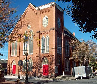
Sight 1: Salem United Church of Christ

Show sight on map
Salem United Church of Christ

The Salem United Church of Christ, formerly known as the Old Salem Reformed Church, is an historic, Reformed church that is located at 231 Chestnut Street in Harrisburg, Dauphin County, Pennsylvania.

Wikipedia: Salem United Church of Christ (Harrisburg, Pennsylvania) (EN)

303 meters / 4 minutes

Sight 2: State Museum of Pennsylvania

Show sight on map
State Museum of Pennsylvania US Census, Ruhrfisch / CC BY-SA 3.0

The State Museum of Pennsylvania is a non-profit history museum at 300 North Street in downtown Harrisburg, Pennsylvania, United States. It is run by the Pennsylvania Historical and Museum Commission to preserve and interpret the Commonwealth's history and culture. It is a part of the Pennsylvania State Capitol Complex.

Wikipedia: State Museum of Pennsylvania (EN), Website , Url

433 meters / 5 minutes

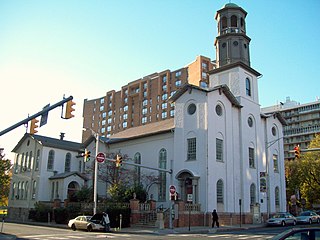
Sight 3: German Evangelical Zion Lutheran Church

Show sight on map
German Evangelical Zion Lutheran Church

The German Evangelical Zion Lutheran Church, which became the Tabernacle Baptist Church in 1967, is an historic Lutheran church that is located at Capital and Herr Streets in Harrisburg, Pennsylvania.

Wikipedia: German Evangelical Zion Lutheran Church (EN)

389 meters / 5 minutes

Sight 4: Stone Building

Show sight on map
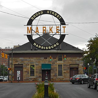
Stone Building

The Broad Street Market, opened in 1863, is located in the Midtown neighborhood of Harrisburg, Pennsylvania in the United States. Originally established on Broad Street by the Verbeke family, it is today one of the oldest continuously operating farmers markets in the country.

Wikipedia: Broad Street Market (EN)

474 meters / 6 minutes

Sight 5: Riverfront Park

Show sight on map
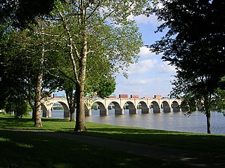
Riverfront Park Samuel Sonne / CC BY-SA 2.5

Riverfront Park is a public park in Harrisburg, Pennsylvania that spans beside the Susquehanna River.

Wikipedia: Riverfront Park (Harrisburg) (EN)

364 meters / 4 minutes

Sight 6: Susquehanna Art Museum

Show sight on map

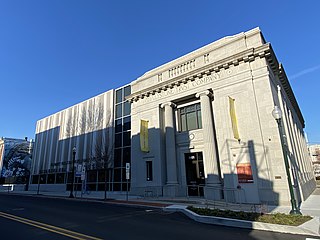
The Susquehanna Art Museum is a non-profit art museum in the United States, located in Midtown Harrisburg, Pennsylvania, the state's capital.

Wikipedia: Susquehanna Art Museum (EN)

513 meters / 6 minutes

Sight 7: Holocaust Memorial for the Commonwealth of Pennsylvania

Show sight on map

The Holocaust Memorial for the Commonwealth of Pennsylvania is a Holocaust memorial at Front and Sayford Streets along Riverfront Park, in Harrisburg, Pennsylvania. It was conceived by a committee of Holocaust survivors in 1992 representing the Jewish Community Center of Harrisburg. In light of publicity given to the U.S. Holocaust Museum, a group of survivors that had lived in the Harrisburg area pressed for a local memorial. It was designed by David Ascalon for $200,000 on a site designated by the City of Harrisburg along the public park land adjacent to the Susquehanna River. The Memorial was dedicated in 1994. An annual Yom Hashoah observance is held at the site.

Wikipedia: Holocaust Memorial for the Commonwealth of Pennsylvania (EN)

906 meters / 11 minutes

Sight 8: Cathedral Parish of Saint Patrick

Show sight on map

The Cathedral of Saint Patrick is a cathedral of the Catholic Church in downtown Harrisburg, Pennsylvania, United States. It is the mother church of the Diocese of Harrisburg and is the seat of its bishop. It is a contributing property in the Harrisburg Historic District on the National Register of Historic Places.

Wikipedia: Cathedral of Saint Patrick (Harrisburg, Pennsylvania) (EN)

624 meters / 7 minutes

Sight 9: A Gathering at the Crossroads

Show sight on map
A Gathering at the Crossroads Governor Tom Wolf / CC BY 2.0

A Gathering at the Crossroads is an African American monument on the southern end of the Pennsylvania State Capitol Complex in Harrisburg, Pennsylvania. Officially dedicated in 2020 to commemorate the 100 and 150-year anniversaries of the passing of the Fifteenth Amendment and Nineteenth Amendment, the monument celebrates the power of the vote and commemorates the historic African American community in Harrisburg and the wider Commonwealth of Pennsylvania between 1850 and 1920.

Wikipedia: A Gathering at the Crossroads (EN)

311 meters / 4 minutes

Sight 10: William Seel Building

Show sight on map
William Seel Building

The William Seel Building is an historic, American commercial building that is located in Harrisburg, Dauphin County, Pennsylvania.

Wikipedia: William Seel Building (EN)

148 meters / 2 minutes

Sight 11: Keystone Building

Show sight on map
Keystone Building

The Keystone Building is a historic, American commercial building that is located in Harrisburg, Dauphin County, Pennsylvania.

Wikipedia: Keystone Building (Harrisburg, Pennsylvania) (EN)

53 meters / 1 minutes

Sight 12: Colonial Theatre

Show sight on map
Colonial Theatre

Colonial Theatre, also known as the Lochiel Hotel, is a historic theater and commercial building located at Harrisburg, Dauphin County, Pennsylvania. The building consists of a five-story, brick and frame front section and a rear brick and frame auditorium. The original Colonial Theatre was built about 1836, as a hotel in the Greek Revival style and featured a four columned portico on the Market Street entrance. It was subsequently modified in form and use a number of times. In the 1870s, a mansard roof was added. The rear auditorium was added in 1912, when the building was converted from a hotel to hotel and movie / vaudeville theater. The lobby was remodeled in the 1930s / 1940s in an Art Deco style; the auditorium has Italian Renaissance style detailing. The theater and hotel closed in 1976, and the building used for offices and shops.

Wikipedia: Colonial Theatre (Harrisburg, Pennsylvania) (EN)

97 meters / 1 minutes

Sight 13: Whitaker Center for Science and the Arts

Show sight on map

The Whitaker Center for Science and the Arts is located in Harrisburg, Pennsylvania. It present exhibits related to science and the performing arts, and also offers a digital cinema.

Wikipedia: Whitaker Center for Science and the Arts (EN), Website

765 meters / 9 minutes

Sight 14: Market Street Bridge

Show sight on map
Market Street Bridge

The Market Street Bridge is a stone arch bridge that spans the Susquehanna River between Harrisburg, Pennsylvania, and Wormleysburg, Pennsylvania. The current structure is the third bridge built at its current location and is the second oldest remaining bridge in Harrisburg. The bridge carries BicyclePA Route J across the river.

Wikipedia: Market Street Bridge (Susquehanna River) (EN)

409 meters / 5 minutes

Sight 15: City Island

Show sight on map

City Island is a mile-long island in the Susquehanna River between Harrisburg and Wormleysburg, Pennsylvania in the United States. It is used mainly for leisure and sports activities. Its previous names have included Turkey Island, Maclay's Island, Forster's Island and Hargast Island. The island can be reached from either side of the Susquehanna River by Market Street Bridge or, from the Harrisburg side and by pedestrians and cyclists only, by Walnut Street Bridge.

Wikipedia: City Island (Pennsylvania) (EN)

Share

Spread the word! Share this page with your friends and family.

Disclaimer Please be aware of your surroundings and do not enter private property. We are not liable for any damages that occur during the tours.

GPX-Download For navigation apps and GPS devices you can download the tour as a GPX file.