Self-guided Sightseeing Tour #1 in Leicester, United Kingdom
Legend
Tour Facts
2.8 km
33 m
Experience Leicester in United Kingdom in a whole new way with our free self-guided sightseeing tour. This site not only offers you practical information and insider tips, but also a rich variety of activities and sights you shouldn't miss. Whether you love art and culture, want to explore historical sites or simply want to experience the vibrant atmosphere of a lively city - you'll find everything you need for your personal adventure here.
Activities in LeicesterIndividual Sights in LeicesterSight 1: Curve

Curve Theatre is a theatre in Leicester, England, based in the cultural quarter in Leicester City Centre. Before being named Curve, it was referred to as Leicester Performing Arts Centre. It is adjacent to the Leicester Athena conference and banqueting centre.
Sight 2: Leicester Secular Society
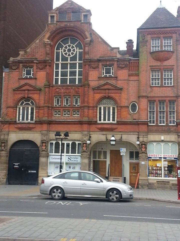
Leicester Secular Hall is a Grade II listed building in Leicester, England. It was built in 1881 for the city's Secular Society.
Sight 3: Clock Tower

The Haymarket Memorial Clock Tower is a major landmark and popular meeting point in Leicester, England. It is located roughly in the middle of the area inside the ring-road, and is at the point where five major streets meet; Gallowtree Gate, Humberstone Gate (A47), Haymarket (A607), Church Gate (A6) and Eastgates (A47).
Sight 4: Silver Arcade

Silver Arcade is a Grade II listed building in the centre of Leicester, England. A former shopping arcade, Silver Arcade was built by Amos Hall in 1889. The top floor was closed off in 2000, leaving the units on the ground floor occupied by a number of independent retailers. In 2008, the centre was the focus of a campaign by the Leicester Civic Society to reopen it.
Sight 5: Cathedral Church of St Martin

The Cathedral Church of Saint Martin, Leicester, commonly known as Leicester Cathedral, is a Church of England cathedral in Leicester, England and the seat of the Bishop of Leicester. The church was elevated to a collegiate church in 1922 and made a cathedral in 1927 following the establishment of a new Diocese of Leicester in 1926.
Wikipedia: Leicester Cathedral (EN), Website, Heritage Website
Sight 6: Greyfriars Church

Greyfriars, Leicester, was a friary of the Order of Friars Minor, commonly known as the Franciscans, established on the west side of Leicester by 1250, and dissolved in 1535. Following dissolution the friary was demolished and the site levelled, subdivided, and developed over the following centuries. The locality has retained the name Greyfriars particularly in the streets named "Grey Friars", and the older "Friar Lane".
Sight 7: Jewry Wall
Get Ticket*
The Jewry Wall is a substantial ruined wall of 2nd-century Roman masonry, with two large archways, in Leicester, England. It stands alongside St Nicholas' Circle and St Nicholas' Church. It formed the west wall of a public building in Ratae Corieltauvorum, alongside public baths, the foundations of which were excavated in the 1930s and are also open to view. The wall gives its name to the adjacent Jewry Wall Museum.
Sight 8: St Nicholas

St Nicholas Church is a Church of England parish church, and the oldest place of worship in Leicester, England.
Sight 9: Jewry Wall Museum

The Jewry Wall Museum is a museum in Leicester in the East Midlands of England. It was built in the 1960s, facing the Jewry Wall ruins in a building shared with Vaughan College. It housed artefacts from Iron Age, Roman, and medieval Leicester. With the ending of Vaughan College's use of the building in 2013, the whole site was acquired by the city council, and expansion and improvement plans were put in place.
Sight 10: St Mary de Castro

St Mary de Castro is an ancient, Grade I listed church in Leicester, England, located within the bailey of Leicester Castle. Today it acts as a Church of England parish church in the Diocese of Leicester. "St Mary de Castro" is Latin for "St Mary of the Castle"; a name chosen to differentiate from nearby "St Mary de Pratis": "St. Mary of the Meadows".
Wikipedia: Church of St Mary de Castro, Leicester (EN), Website, Heritage Website
Sight 11: ISKCON

ISKCON Leicester is a Hare Krishna temple located in central Leicester, in the East Midlands region of England. The temple is one of sixteen religious and cultural centers run by the International Society for Krishna Consciousness (ISKCON) in the United Kingdom. The temple follows the Krishnaism or Krishna-centric traditions of the Gaudiya Vaishnava denomination within Hinduism. Their philosophy is based on Sanskrit texts known as the Bhagavad Gita and the Bhagavat Purana. Unlike some forms of Hinduism, the Gaudiya Vaishnava tradition is monotheistic and worship Krishna as the highest form of God and the source of all the avatars of God.
Share
How likely are you to recommend us?
Disclaimer Please be aware of your surroundings and do not enter private property. We are not liable for any damages that occur during the tours.
GPX-Download For navigation apps and GPS devices you can download the tour as a GPX file.