Self-guided Sightseeing Tour #19 in Krakow, Poland

Legend

Churches & Art
Nature
Water & Wind
Historical
Heritage & Space
Tourism
Paid Tours & Activities

Tour Facts

Number of sights 22 sights
Distance 10.8 km
Ascend 180 m
Descend 175 m

Experience Krakow in Poland in a whole new way with our self-guided sightseeing tour. This site not only offers you practical information and insider tips, but also a rich variety of activities and sights you shouldn't miss. Whether you love art and culture, want to explore historical sites or simply want to experience the vibrant atmosphere of a lively city - you'll find everything you need for your personal adventure here.

Activities in KrakowIndividual Sights in Krakow

Sight 1: Museum of Contemporary Art in Krakow

Show sight on map
Museum of Contemporary Art in Krakow

The Museum of Contemporary Art in Kraków (MOCAK),, is a contemporary art gallery in Kraków, Poland that opened on 19 May 2011. Situated 3 kilometres from the centre of the city, on a demolished part of the factory of Oskar Schindler, the aim of the gallery is to present and support contemporary art and artists, in particular art from the last two decades.

Wikipedia: Museum of Contemporary Art in Kraków (EN)

596 meters / 7 minutes

Sight 2: Skład Solny

Show sight on map

Salt Warehouse – an eighteenth-century salt warehouse located in Kraków next to the former Salt Port at 8 Na Zzjazd Street, in Podgórze in Zabłocie.

Wikipedia: Dawny Skład Solny w Krakowie (PL)

298 meters / 4 minutes

Sight 3: Eagle Pharmacy

Show sight on map
Eagle Pharmacy Zygmunt Put Zetpe0202 / CC BY-SA 4.0

The Eagle Pharmacy Museum is located on the southwest edge of the Bohaterów Getta Square, under number 18 in Kraków, Poland.

Wikipedia: Eagle Pharmacy (EN), Website

449 meters / 5 minutes

Sight 4: Cricoteka

Show sight on mapGet Ticket*

The Centre for the Documentation of the Art of Tadeusz Kantor CRICOTEKA – a cultural institution of the local government of the Lesser Poland Voivodeship, founded in 1980, operating at 2/4 Nadwiślańska Street, in the building of the former Podgórze power plant.

Wikipedia: Ośrodek Dokumentacji Sztuki Tadeusza Kantora Cricoteka (PL), Website

369 meters / 4 minutes

Sight 5: Kładka Ojca Bernatka

Show sight on map
Kładka Ojca Bernatka Zygmunt Put Zetpe0202 / CC BY-SA 4.0

Father Bernatek's Footbridge – a pedestrian and bicycle bridge on the Vistula River in Kraków, connecting Kazimierz with Podgórze, built in the place of the former Podgórski Bridge. By the decision of the Krakow City Council, it was named after Father Laetus Bernatek, a monk who at the turn of the 19th and 20th centuries led to the construction of the buildings of the Hospitallers in Krakow.

Wikipedia: Kładka Ojca Bernatka (PL), Website

380 meters / 5 minutes

Sight 6: Muzeum Etnograficzne (Dom Esterki)

Show sight on map

Esterka's House is a tenement house in Krakow's Kazimierz district, at 46 Krakowska Street, at the corner with Trynitarska Street.

Wikipedia: Dom Esterki w Krakowie (PL)

145 meters / 2 minutes

Sight 7: Piotr Skrzynecki

Show sight on map
Piotr Skrzynecki Zygmunt Put Zetpe0202 / CC BY-SA 4.0

The Monument of Piotr Skrzynecki is a monument located in Krakow's Kazimierz district, at 8 Skawińska Street.

Wikipedia: Pomnik Piotra Skrzyneckiego w Krakowie (ul. Skawińska) (PL)

228 meters / 3 minutes

Sight 8: Kościół pw. Świętej Trójcy

Show sight on map

The Church of the Holy Trinity is a Roman Catholic conventual church of the Brothers Hospitallers located in Kraków, in District I at 48 Krakowska Street, in Kazimierz.

Wikipedia: Kościół Świętej Trójcy w Krakowie (ul. Krakowska) (PL)

594 meters / 7 minutes

Sight 9: Planty Floriana Nowackiego

Show sight on map
Planty Floriana Nowackiego Zygmunt Put Zetpe0202 / CC BY-SA 4.0

Florian Nowacki Planty Park – the oldest park in Podgórze located near the mouth of the Wilga River into the Vistula, between the following streets: Władysława Warneńczyka, Sokolska, Karol Rollego, Jana Długosza on Emil Serkowski Square.

Wikipedia: Planty im. Floriana Nowackiego w Krakowie (PL)

832 meters / 10 minutes

Sight 10: Kościół pw. Świętego Bartłomieja

Show sight on map

St. Bartholomew's Church – a historic Roman Catholic church in the Podwawelskie Housing Estate, at 25 Komandosów Street in District VIII Dębniki in Krakow.

Wikipedia: Kościół św. Bartłomieja w Krakowie (os. Podwawelskie) (PL)

556 meters / 7 minutes

Sight 11: Kościół pw. Matki Boskiej Fatimskiej

Show sight on map
Kościół pw. Matki Boskiej Fatimskiej Zygmunt Put Zetpe0202 / CC BY-SA 4.0

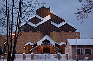
The Church of Our Lady of Fatima – a Roman Catholic parish church located in the Podwawelskie Housing Estate, at 18 Komandosów Street, in the administrative district VIII in Krakow. Since 2020, the parish priest is Fr. Jarosław Nowak.

Wikipedia: Kościół Matki Boskiej Fatimskiej w Krakowie (ul. Komandosów) (PL), Website

1212 meters / 15 minutes

Sight 12: Kościół pw. Boskiego Zbawiciela

Show sight on map

The Church of the Divine Savior is a Roman Catholic church of the Salvatorians designed in the postmodern style. It is located in Krakow's Zakrzówek at 16 St. Jacka Street.

Wikipedia: Kościół Boskiego Zbawiciela w Krakowie (PL)

673 meters / 8 minutes

Sight 13: Kawerna Magazyn

Show sight on map
Kawerna Magazyn A. Górny, M. Szelerewicz / CC BY 3.0

The Warehouse Cavern is a cavern in the Skałki Twardowskiego wilderness in District VIII of Dębniki, Kraków. It is located in the rock wall of the closed Kapelanka quarry, more precisely at the base of the north-eastern section of the wall of this wall called Rusty Jam.

Wikipedia: Kawerna Magazyn (PL), Website

1146 meters / 14 minutes

Sight 14: Grota Twardowskiego

Show sight on map

Twardowski Cave – a large karst cave in District VIII Dębniki in Kraków. It is located on the south-western edge of the Krzemionki Zakrzowskie hill, a short distance from the concrete fence of the Military Unit. A path runs between this fence and the cave opening. The cave is visible from it.

Wikipedia: Jaskinia Twardowskiego (PL)

30 meters / 0 minutes

Sight 15: Jaskinia Niska

Show sight on map

Niska Cave is a cave in District VIII Dębniki in Kraków. It is located on the south-western edge of the Krzemionki Zakrzowskie hill, a short distance from the concrete fence of the military unit. A path runs between this fence and the cave opening. The cave is located about 150 m from the gate of the vessel.

Wikipedia: Jaskinia Niska (Zakrzówek) (PL)

18 meters / 0 minutes

Sight 16: Jaskinia pod Nyżą

Show sight on map
Jaskinia pod Nyżą A. Górny / CC BY-SA 2.5

The Cave under Nyża is a cave in District VIII of Dębniki in Kraków. It is located on the south-western edge of the Krzemionki Zakrzowskie hill.

Wikipedia: Jaskinia pod Nyżą (PL)

52 meters / 1 minutes

Sight 17: Jaskinia z Kulkami

Show sight on map
Jaskinia z Kulkami B. Słobodzian / CC BY-SA 2.5

The Cave with Balls is a cave in District VIII of Dębniki in Kraków. It is located on the south-western edge of the Krzemionki Zakrzowskie hill.

Wikipedia: Jaskinia z Kulkami (PL)

561 meters / 7 minutes

Sight 18: Jaskinia Pychowicka

Show sight on map
Jaskinia Pychowicka P. Kulbicki / CC BY-SA 2.5

Pychowicka Cave, Shelter in the quarry next to Twardowski II Cave, Vistula Cave – karst cave in District VIII Dębniki in Krakow. It is located in the eastern wall of the Berger's Łom quarry on Góra Księża in Pychowice at Norymberska Street.

Wikipedia: Jaskinia Pychowicka (PL)

621 meters / 7 minutes

Sight 19: Jaskinia Jasna

Show sight on map
Jaskinia Jasna Mariusz Szelerewicz / CC BY-SA 2.5

Jasna Cave – a karst cave, located in Kraków, in the north-western part of the log hill of Krzemionki Zakrzowskie, in the part called Twardowski's Rocks, near the Vistula River.

Wikipedia: Jaskinia Jasna (Zakrzówek) (PL)

181 meters / 2 minutes

Sight 20: Jaskinia Wywiew

Show sight on map
Jaskinia Wywiew Andrzej Górny / CC BY-SA 2.5

Wywiew is a cave in District VIII of Dębniki in Kraków. It is located on the south-western edge of the Krzemionki Zakrzowskie hill.

Wikipedia: Jaskinia Wywiew (PL)

495 meters / 6 minutes

Sight 21: Skałki Twardowskiego

Show sight on map

Uroczysko Skałki Twardowskiego – a city park in Kraków, which is a fragment of the Municipal Forests of Kraków, located on the logging hill of Krzemionki Zakrzowskie, in the right-bank part of Kraków, in district VIII, in Dębniki.

Wikipedia: Skałki Twardowskiego (PL)

1405 meters / 17 minutes

Sight 22: Kościół pw. Emaus

Show sight on map

The Church of Emmaus is a Roman Catholic seminary church located in Kraków at 1 Pawlickiego Street, in district VIII.

Wikipedia: Kościół Emaus w Krakowie (PL)

Share

Spread the word! Share this page with your friends and family.

Disclaimer Please be aware of your surroundings and do not enter private property. We are not liable for any damages that occur during the tours.

GPX-Download For navigation apps and GPS devices you can download the tour as a GPX file.