100 Sights in Krakow, Poland (with Map and Images)
Legend
Premium Sights
Book tickets, guided tours and activities in Krakow.
Guided Free Walking Tours
Book free guided walking tours in Krakow.
Welcome to your journey through the most beautiful sights in Krakow, Poland! Whether you want to discover the city's historical treasures or experience its modern highlights, you'll find everything your heart desires here. Be inspired by our selection and plan your unforgettable adventure in Krakow. Dive into the diversity of this fascinating city and discover everything it has to offer.
Sightseeing Tours in KrakowActivities in Krakow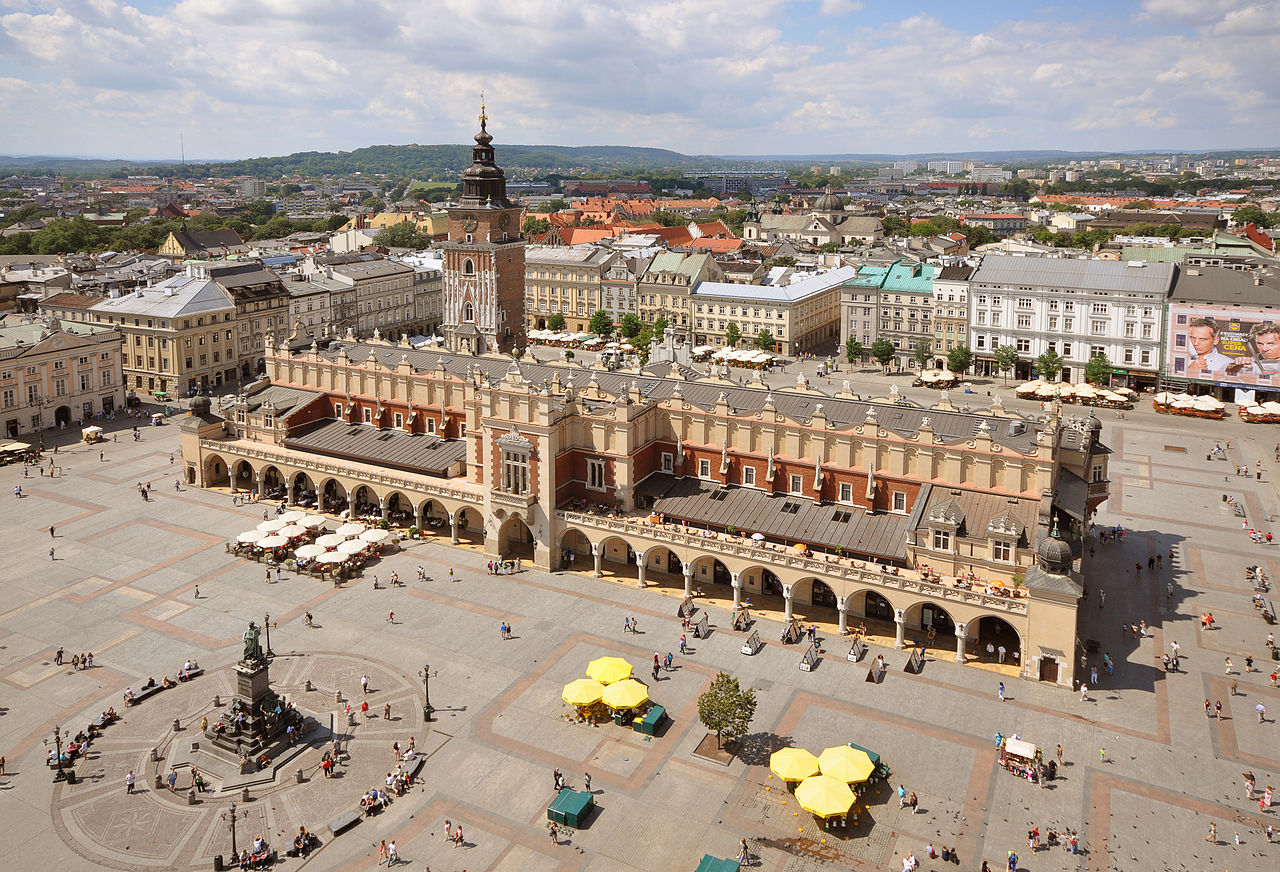
The Main Square of the Old Town of Kraków, Lesser Poland, is the principal urban space located at the center of the city. It dates back to the 13th century, and at 3.79 ha is sometimes called the largest medieval town square in Europe, but Charles Square in Prague is two times larger. The Project for Public Spaces (PPS) lists the square as the best public space in Europe due to its lively street life, and it was a major factor in the inclusion of Kraków as one of the top off-the-beaten-path destinations in the world in 2016.

The Kraków Cloth Hall, in Lesser Poland, dates to the Renaissance and is one of the city's most recognizable monuments. It is the central feature of the main market square in the Kraków Old Town, which since 1978 has been listed as a UNESCO World Heritage Site.

The Galicia Jewish Museum is located in the historic Jewish district of Kazimierz in Kraków, Poland. It is a photo exhibition documenting the remnants of Jewish culture and life in Polish Galicia, which used to be very vibrant in this area.
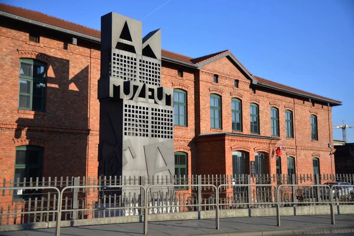
The Home Army Museum was created in Kraków, Poland in 2000, to commemorate the struggle for independence by the underground Polish Secret State and its military arm, the Hope Army, the largest resistance movement in occupied Europe during World War II. The museum is named after general Emil August Fieldorf "Nil". It is the only such institution in Poland promoting knowledge about the Polish Underground State and its armed forces during World War II. The idea behind the Home Army Museum is to provide a holistic picture of the Polish underground, its spiritual origins and the shape of patriotic heritage to the present day.

Wawel Dragon Statue is a monument at the foot of the Wawel Hill in Kraków, Poland, in front of the Wawel Dragon's den, dedicated to the mythical Wawel Dragon. Installed in 1972, the statue is capable of letting out fire from its mouth on demand.

The Centre for the Documentation of the Art of Tadeusz Kantor CRICOTEKA – a cultural institution of the local government of the Lesser Poland Voivodeship, founded in 1980, operating at 2-4 Nadwiślańska Street, in the building of the former Podgórze power plant.
Wikipedia: Ośrodek Dokumentacji Sztuki Tadeusza Kantora Cricoteka (PL), Website

Saint Mary's Basilica is a Brick Gothic church adjacent to the Main Market Square in Kraków, Poland. Built in the 14th century, its foundations date back to the early 13th century and serve as one of the best examples of Polish Gothic architecture. Standing 80 m (262 ft) tall, it is particularly famous for its wooden altarpiece carved by Veit Stoss (Wit Stwosz). Some of its monumental polychrome murals were designed by Poland's leading history painter, Jan Matejko (1838–1893). In 1978 it became a UNESCO World Heritage Site alongside the Historic Centre of Kraków.
8. Zamek Wawel

The Wawel Royal Castle and the Wawel Hill on which it sits constitute the most historically and culturally significant site in Poland. A fortified residency on the Vistula River in Kraków, it was established on the orders of King Casimir III the Great and enlarged over the centuries into a number of structures around an Italian-styled courtyard. It represents nearly all European architectural styles of the Medieval, Renaissance and Baroque periods.
9. Płaszów Niemiecki nazistowski obóz koncentracyjny

Płaszów or Kraków-Płaszów was a Nazi concentration camp operated by the SS in Płaszów, a southern suburb of Kraków, in the General Governorate of German-occupied Poland. Most of the prisoners were Polish Jews who were targeted for destruction by Nazi Germany during the Holocaust. Many prisoners died because of executions, forced labor, and the poor conditions in the camp. The camp was evacuated in January 1945, before the Red Army's liberation of the area on 20 January.
10. Royal Archcathedral Basilica of Saints Stanislaus and Wenceslaus

The Wawel Cathedral, formally titled the Archcathedral Basilica of Saint Stanislaus and Saint Wenceslaus, is a Catholic cathedral situated on Wawel Hill in Kraków, Poland. Nearly 1000 years old, it is part of the Wawel Castle Complex and is a national sanctuary which served as the coronation site of Polish monarchs.
11. Muzeum Książąt Czartoryskich w Krakowie

The Princes Czartoryski Museum – often abbreviated to Czartoryski Museum – is a historic museum in Kraków, Poland, and one of the country's oldest museums. The initial collection was formed in 1796 in Puławy by Princess Izabela Czartoryska. The Museum officially opened in 1878. It is now a division of the National Museum in Kraków.
12. Hugo Kołłątaj

Hugo Stumberg Kołłątaj, also spelled Kołłątay, was a prominent Polish constitutional reformer and educationalist, and one of the most prominent figures of the Polish Enlightenment. He served as Deputy Chancellor of the Crown between 1791–92. He was a Catholic priest, social and political activist, political thinker, historian, philosopher, and polymath.
13. Kościół pw. Świętej Katarzyny Aleksandryjskiej

The Church of St. Catherine of Alexandria and St. Margaret – a historic Roman Catholic church with the Augustinian Hermit monastery located in Krakow, in the First Old Town district at 7–9 Augustiańska Street, in Kazimierz. The Augustinian convent and the church are located between Skałeczna, Augustiańska, Paulińska and Skałka streets.
Wikipedia: Kościół św. Katarzyny Aleksandryjskiej i św. Małgorzaty w Krakowie (PL), Website
14. Benedictine Abbey in Tyniec

The Benedictine Abbey in Tyniec together with the Church of St. Peter and St. Paul is a Benedictine abbey in Tyniec in the south-western part of Krakow. The abbey in Tyniec is the oldest existing monasteries in Poland.
15. National Museum in Kraków
The National Museum in Kraków, popularly abbreviated as MNK, is the largest museum in Poland, and the main branch of Poland's National Museum, which has several independent branches with permanent collections around the country. Established in 1879, the museum consists of 21 departments which are divided by art period: 11 galleries, 2 libraries, and 12 conservation workshops. It holds some 780,000 art objects, spanning from classical archeology to modern art, with special focus on Polish painting. In 2023, the museum was visited by over 1.65 million people, making it the third most-visited art museum in Poland and the 37th most-visited art museum in the world.
16. Pies Dżok

Dżok ("Jock") was a black mongrel dog who was seen waiting in vain for the entire year (1990–1991) at the Rondo Grunwaldzkie roundabout in Kraków, Poland, to be fetched back by his master, who had died there. A monument to Dżok is located on the Czerwieński Boulevard on the Vistula River in Kraków, near the Wawel Castle and the Grunwald Bridge.
17. Saint Florian's Gate

St. Florian's Gate or Florian Gate in Kraków, Poland, is one of the best-known Polish Gothic towers, and a focal point of Kraków's Old Town. It was built about the 14th century as a rectangular Gothic tower of "wild stone", part of the city fortifications against Tatar attack.
18. Skałki Twardowskiego

Uroczysko Skałki Twardowskiego – a city park in Kraków, which is a fragment of the Municipal Forests of Kraków, located on the logging hill of Krzemionki Zakrzowskie, in the right-bank part of Kraków, in district VIII, in Dębniki.
19. Ołtarz Wita Stwosza

The Altarpiece by Veit Stoss, also St. Mary's Altar, is a large Gothic altarpiece and a national treasure of Poland. It is located behind the high altar of St. Mary's Basilica in the city of Kraków. The altarpiece was carved between 1477 and 1489 by the German-born sculptor Veit Stoss who lived and worked in the city for over 20 years.
20. Kościół pw. Świętego Krzyża

The Church of the Holy Cross is a historic Roman Catholic parish church located in Kraków, in the First District of the Old Town at 2 Holy Spirit Square, next to the Juliusz Słowacki Theatre, in the Old Town.
21. Oskar Schindler's Enamel Factory

Oskar Schindler's Enamel Factory is a former metal item factory in Kraków. It now hosts two museums: the Museum of Contemporary Art in Kraków, on the former workshops, and a branch of the Historical Museum of the City of Kraków, situated at ul. Lipowa 4 in the district of Zabłocie, in the administrative building of the former enamel factory known as Oskar Schindler's Deutsche Emailwarenfabrik (DEF), as seen in the film Schindler's List. Operating here before DEF was the first Malopolska factory of enamelware and metal products limited liability company, instituted in March 1937.
22. Kościół pw. Świętego Michała Archanioła i Świętego Stanisława Biskupa
Saint Michael the Archangel and Saint Stanislaus the Bishop and Martyr Basilica, also known as Skałka, which means "a small rock" in Polish, is a small outcrop in Kraków atop of which a Pauline monastery is located.
23. Kościół pw. Świętego Augustyna i Świętego Jana Chrzciciela w Krakowie

Church of St. Augustine and St. John the Baptist – a historic Roman Catholic parish church and monastery of the Norbertine nuns located in Kraków, in district VII Zwierzyniec at 88 Tadeusza Kościuszki Street, in Zwierzyniec. Together with the adjacent Norbertine monastery, it forms the largest historic complex of the city after Wawel.
Wikipedia: Kościół św. Augustyna i św. Jana Chrzciciela w Krakowie (PL)
24. Synagoga Remuh

The Remah Synagogue, formally known as the Isaak Jakubowicz Synagogue, is an Orthodox Jewish congregation and synagogue, located at 40 Szeroka Street, in the historic Kazimierz district of Kraków, in the Lesser Poland Voivodeship of Poland.
25. Pomorska Street

The Historical Museum of the City of Kraków in Kraków, Lesser Poland, was granted the status of an independent institution in 1945. Originally, it was a branch of the Old Records Office of Kraków, in operation from 1899.
26. Kładka Ojca Bernatka

Father Bernatek's Footbridge – a pedestrian and bicycle bridge on the Vistula River in Kraków, connecting Kazimierz with Podgórze, built in the place of the former Podgórski Bridge. By the decision of the Krakow City Council, it was named after Father Laetus Bernatek, a monk who at the turn of the 19th and 20th centuries led to the construction of the buildings of the Hospitallers in Krakow.
27. Kościół pw. Najświętszego Salwatora

The Church of the Most Holy Salvatore – a historic Roman Catholic church located in Kraków, in district VII Zwierzyniec at St. Bronisława Street, on a small hill constituting the eastern end of the massif of St. Bronisława Mountain, in Zwierzyniec.
Wikipedia: Kościół Najświętszego Salwatora w Krakowie (PL), Website
28. National Museum The Nineteenth Century Polish Art Gallery at the Sukiennice
The Gallery of 19th-Century Polish Art at Sukiennice, is a division of the National Museum, Kraków, Poland. The gallery is housed on the upper floor of the Renaissance Sukiennice Cloth Hall in the center of the Main Market Square in Old Town Kraków.
29. Synagoga Tempel w Krakowie

The Tempel Synagogue is a Reform Jewish congregation and synagogue, located at 24 Miodowa Street, in the historic Kazimierz district of Kraków, in the Lesser Poland Voivodeship of Poland. Designed by Ignacy Hercok in the Moorish Revival and Rundbogenstil styles and completed in 1862, the synagogue is a major place of worship, and also a booming center of Jewish culture, which hosts numerous concerts and meetings, especially during the Kraków Jewish Culture Festival.
30. Fort główny artyleryjski 49 Krzesławice

Main artillery fort 49 "Krzesławice" – a typical single-rampart artillery fort constituting an important element of the north-eastern section, the so-called Third ring of Austrian fortifications of the Kraków Fortress. Located in the current area of the Nowa Huta housing estate Na Stoku at Architektów Street in District XVII Wzgórza Krzesławickie in Krakow. The fort houses the Fort 49 "Krzesławice" Youth Cultural Centre, and the fort's surroundings are a recreational park with alleys and benches.
31. Kościół pw. Matki Boskiej Częstochowskiej

The Church of Our Lady of Czestochowa and Blessed Wincenty Kadłubek is a Roman Catholic parish church and conventual church of the Cistercians located in Kraków, in the XVIII district of Nowa Huta in the Szklane Domy 7 estate in Nowa Huta.
Wikipedia: Kościół Matki Boskiej Częstochowskiej w Krakowie (os. Szklane Domy) (PL), Website
32. Kościół Zwiastowania Najświętszej Maryi Panny

The Church of the Annunciation of the Blessed Virgin Mary – a historic Roman Catholic conventual church of the Capuchins located in Krakow, in the Old Town district I at 11 Loretańska Street, on the Sand Island.
Wikipedia: Kościół Zwiastowania Najświętszej Maryi Panny w Krakowie (PL)
33. Kościół pw. Świętego Tomasza Apostoła

Church of St. Thomas the Apostle – a historic Roman Catholic conventual church of the Holy Spirit, located in Krakow, in the Old Town district I at 14 Szpitalna Street, at the corner with 23 St. Thomas Street, in the Old Town.
34. Kraków Philharmonic

The Kraków Philharmonic is the primary concert hall in Kraków, Poland. It is one of the largest auditoriums in the city. It consists of the main hall for orchestral performances with 693 seats, and two smaller venues, the Golden Hall and the Blue Hall, for chamber music concerts.
35. Teatr Groteska

The "Groteska" Theatre is a theatre in Kraków, at 2 Skarbowa Street, especially known for puppet performances and performances in the theatre of form and dance theatre. It was created as a children's theatre, and currently it also operates as a stage for mature audiences. In addition to its repertoire activities, the Theatre is the initiator of the m.in Great Dragon Parade, the Materia Prima International Festival of Theatre of Form and the Masters' Code – a series of meetings with authorities of social and artistic life. In addition, the Theatre organises workshops for children and teachers and joins social and artistic projects.
36. Kościół pw. Świętego Jana Chrzciciela i Świętego Jana Ewangelisty

Church of St. John the Baptist and St. John the Evangelist – a historic, Roman Catholic church of the Sisters of the Presentation Sisters located in Krakow, in the Old Town district I at 7a St. John Street, in the Old Town. The church is a sanctuary of: Our Lady of the Redemption of Slaves, Our Lady of Freedom, Our Lady of St. John's Day, Blessed Sophia of Bohemia.
Wikipedia: Kościół św. Jana Chrzciciela i św. Jana Ewangelisty w Krakowie (PL)
37. Kościół pw. Przemienienia Pańskiego

The Church of the Transfiguration is a historic sacral complex, a Roman Catholic Piarist conventual church and an adjacent monastery, located in Kraków, in the First District of the Old Town at 4 Pijarska Street, in the Old Town.
Wikipedia: Kościół Przemienienia Pańskiego w Krakowie (ul. Pijarska) (PL)
38. Church of Saint Andrew

The Church of St. Andrew in the Old Town district of Kraków, Poland located at Grodzka Street, is a historical Romanesque church built between 1079 and 1098 by a medieval Polish statesman Palatine Sieciech. It is a rare surviving example of the European fortress church used for defensive purposes.
39. Kościół pw. Świętej Anny

The Church of St. Anne is a Roman Catholic church located at 13 św. Anny Street in the UNESCO-protected historic centre of Kraków, Poland. It is one of the leading examples of Polish Baroque architecture designed by Tylman van Gameren, but the church's history dates back to 14th century.
40. St. Adalbert's church

The Church of St. Adalbert or the Church of St. Wojciech, located on the intersection of the Main Market Square and Grodzka Street in Old Town, Kraków, is one of the oldest stone churches in Poland. Its almost 1000-year-old history goes back to the beginning of the Polish Romanesque architecture of the early Middle Ages. Throughout the early history of Kraków the Church of St. Wojciech was a place of worship first visited by merchants travelling from across Europe. It was a place where citizens and nobility would meet.
41. Kościół pw. Świętego Franciszka Salezego

Church of St. Francis de Sales – a historic Roman Catholic church and Visitation Convent located in Kraków, in the Old Town district I at 16 Krowoderska Street, at the corner with Biskupia Street, on the Sand Island.
42. Synagoga Kupa

The Kupa Synagogue, also known as the Synagogue of the Poor, is a former Jewish congregation and synagogue, that is located at 8 Warszauera Street, in the historic Kazimierz district of Kraków, in the Lesser Poland Voivodeship of Poland. The 17th-century former synagogue is located in a neighborhood earmarked in 1495 by King John I Albert for the Jewish community, that was transferred from the budding Old Town.
43. Kościół pw. Niepokalanego Poczęcia Najświętszej Maryi Panny

The Church of the Immaculate Conception of the Blessed Virgin Mary is a historic Roman Catholic conventual church of the Discalced Carmelites located in Kraków, in the II Grzegórzki district at 18 Rakowicka Street, in the Warsaw district.
Wikipedia: Kościół Niepokalanego Poczęcia Najświętszej Maryi Panny w Krakowie (ul. Rakowicka) (PL)
44. Kościół pw. Świętego Floriana

The Collegiate Church of St. Florian is a historic church in Kraków, Poland. It stands at the northern end of Matejko Square and the former centre of the mediaeval city of Kleparz, now a district of Kraków. The edifice marks the beginning of the Royal Road.
45. Kościół pw. Świętego Józefa Oblubieńca Najświętszej Maryi Panny

Church of St. Joseph the Spouse of the Blessed Virgin Mary – built in the postmodern style, in the years 1993-2002, a Roman Catholic parish church. It is located in Krakow at the Kalinowy 5 estate in Bieńczyce.
Wikipedia: Kościół św. Józefa Oblubieńca Najświętszej Maryi Panny w Krakowie (PL)
46. Jordan Park

Jordan Park was established in 1889 as the first public playground in Kraków, Poland, and the first of its kind in Europe. It was equipped with exercise fixtures modeled after those of similar playgrounds in the United States. The park is located in Kraków’s Błonia.
47. Synagoga Izaaka Jakubowicza

The Izaak Synagogue, formally known as the Isaak Jakubowicz Synagogue, is an Orthodox Jewish congregation and synagogue, located at 18 Kupa Street, in the historic Kazimierz district of Kraków, in the Lesser Poland Voivodeship of Poland. Designed by Francesco Olivierri in the Baroque style and completed in 1644, the synagogue is named for its donor, Izaak Jakubowicz, also called Isaac the Rich, a banker to King Ladislaus IV of Poland.
48. Sowiniec
Sowiniec – the highest hill of the Sowiniec Range in Krakow. Together with the Piłsudski Mound located on its top, it reaches a height of 383.6 m above sea level. Geographically, it is located within the Kraków Bridge, which is included in the macroregion of the Kraków Gate.
49. Church of Saints Peter and Paul

The Church of Saints Peter and Paul is a Roman Catholic Polish Baroque church located at 54 Grodzka Street in the Old Town district of Kraków, Poland. It was built between 1597–1619 by Giovanni Maria Bernardoni who perfected the original design of Józef Britius. It is the biggest of the historic Churches of Kraków in terms of seating capacity. Since 1842 it serves the Catholic All Saints parish.
50. Kościół pw. Świętego Wincentego à Paulo

Church of St. Vincent de Paul – a historic, neo-Gothic, conventual Roman Catholic church of the Missionaries of Vincent de Paul, located in Krakow, in the First District of the Old Town at 17–19 St. Philip Street, in the Kleparz district.
51. Piłsudski's Mound

Piłsudski's Mound is located in Kraków, Poland, and was established by the Polish nation in honor of Józef Piłsudski. An artificial mound, it was constructed between the years 1934 and 1937. It is located in the western part of Kraków, on the Sowiniec Heights, Kraków's VII District "Zwierzyniec". It is the newest and largest of Kraków's four mounds.[a]
52. Kościół pw. Niepokalanego Poczęcia Najświętszej Maryi Panny

The Church of the Immaculate Conception of the Blessed Virgin Mary – a historic Roman Catholic hospital church located in Kraków, in the II Grzegórzki district at 19 Mikołaja Kopernika Street, in Wesoła Street.
Wikipedia: Kościół Niepokalanego Poczęcia Najświętszej Maryi Panny w Krakowie (ul. Kopernika) (PL)
53. Kościół pw. Matki Boskiej Fatimskiej

The Church of Our Lady of Fatima – a Roman Catholic parish church located in the Podwawelskie Housing Estate, at 18 Komandosów Street, in the administrative district VIII of Dębniki in Krakow. Since 2020, the parish priest is Fr. Jarosław Nowak.
Wikipedia: Kościół Matki Boskiej Fatimskiej w Krakowie (ul. Komandosów) (PL), Website
54. Park imienia Wojciecha Bednarskiego

Park Wojciech Bednarski - a historic city park in Krakow, located in District XIII Podgórze. It is located on the southern side of the center of Podgórze in the cavity of the area resulting from limestone operation between the streets: Krzemionki in the west, park in the east and Zamoyski in the north. It covers an area of 8.46 ha. The entrances to the park are located at ul. Parkowa and Zamoyski.
55. Synagoga Wysoka

The High Synagogue was a former Orthodox Jewish congregation and synagogue, also known as the Tall Synagogue, located at Jozefa 38 Street, in the Kazimierz district of Kraków, in the Małopolskie Voivodeship of Poland.
56. Lokomotywa AGH Ty2-559

AGH UST locomotive – Ty2-559 series Ty2 freight steam locomotive, placed as a monument-technical monument in front of the building of the Faculty of Metals Engineering and Industrial Computer Science of the AGH University of Science and Technology in Kraków. It weighs 115 tons and is 23 meters long.
57. Opera Krakowska

The Opera Krakowska is an opera house located in Kraków, Poland. It was founded in 1954 in postwar Kraków, although the tradition of opera in the city dates back to 1628 when the first ever full libretto in Polish was released by the local publishing house, followed by the first fully-fledged opera performance in the city in March 1782. The Kraków Opera company stages 200 performances each year, including ballet, operettas and musicals for the young, with an audience occupancy rate of 98%. The Kraków Opera's main repertoire includes both international and Polish operatic classics, reaffirming its status as one of the country's leading opera companies.
58. Kościół pw. Świętego Kazimierza Królewicza

The Church of St. Casimir the Prince in Kraków, Poland – with the adjacent Franciscan monastery and the catacombs – is located at ul. Reformacka 4 street in the Old Town district. Members of the Catholic Order of Franciscans known as "Little Brothers" arrived in Kraków in 1622 and settled at the outskirts of the town in Garbary (1625).
59. Dom Pod Krzyżem

The House under the Cross is a building at 21 Szpitalna Street in Kraków. Originally the seat of St. Roch's Hospital and the chapel of the same name, it now houses the Centre for the Interpretation of the Intangible Heritage of Krakow of the Historical Museum of the City of Krakow.
60. Hujowa Górka

Hujowa Górka is a place near the site of Kraków-Płaszów concentration camp, where in April 1944 the Nazis exhumed and incinerated the bodies of around ten thousand previously killed Jews, to hide the evidence of the crime before retreating from the area. The place took its name from the surname of Unterscharführer Albert Hujar who committed and directed the executions. It is also a mockery of Hujar's surname, which is pronounced similarly to a vulgar Polish language expression for "penis", hence the name is Polish for "Prick Hill", because it could be seen from almost any part of the camp. Before World War II, an old Austrian fortification of the 19th century, dismantled in the 1930s, had been located on a hill. After destroying the fort, a large hexagonal pit remained here, with a circumference of up to 50 meters and a depth of up to 5 meters.
61. Bastion IVa Luneta Warszawska

Fort 12 (IVa) "Luneta Warszawska" – a historic redoubt fort built in the years 1850–1856, part of the fortification system of the Kraków Fortress, located at the intersection of Kamienna Street and 29 Listopada Avenue in Kraków, entered into the register of immovable monuments of the Lesser Poland Voivodeship.
62. Teatr Łaźnia Nowa

Łaźnia Nowa Theatre is the newest dramatic theatre in Kraków, Poland, founded in 2005. It is located in the district of Nowa Huta which was built from the ground up during the 1950s' Communist policy of Socialist realism. Appropriately, the theatre is residing in the post-industrial halls of a former technical school.
63. Kaplica Świętej Małgorzaty i Świętej Judyty

The Chapel of St. Margaret and St. Judith – a historic Baroque, wooden chapel located in Krakow, in district VII Zwierzyniec at 8 St. Bronisława Street, in Salwator. It is located on the route of the Małopolska Wooden Architecture Route.
64. Kaplica Czartoryskich

The Chapel of the Passion of Christ, called the Czartoryski Chapel, originally a chapter house – a Roman Catholic temple of historic character, belonging to the archcathedral parish of St. Stanislaus BM and St. Wenceslaus in Krakow. It is one of the public chapels of the Cathedral Basilica of St. Stanislaus and St. Wenceslaus in Krakow at Wawel. It is located in the ground floor of the Clock Tower, at the northern aisle of the cathedral, west of the vestibule leading to the chapter house.
65. Kościół pw. Matki Bożej Nieustającej Pomocy

The Church of Our Lady of Perpetual Help is a historic Roman Catholic parish and conventual church of the Redemptorists located in Kraków, in district XIII Podgórze at 56 J. Zamoyskiego Street, in Podgórze.
Wikipedia: Kościół Matki Boskiej Nieustającej Pomocy w Krakowie (ul. Zamoyskiego) (PL), Website, Facebook
66. Camaldolese Hermit Monastery

Camaldolese Hermit Monastery in Kraków is a Camaldolese priory in Bielany in Kraków, Poland. The monastery is located on the 326-metre (1,070 ft) Silver Mount. It consists of hermitages and the Assumption of Mary Church.
67. Bazylika Wniebowzięcia Najświętszej Maryi Panny i Świętego Wacława

Mogiła Abbey is a Cistercian monastery in the Nowa Huta District of Kraków, Poland. The abbey was founded in 1222 by the Bishop of Kraków, Iwo Odrowąż. The religious complex was built for religious reasons as well as for prestige. It was the largest and most impressive church in medieval Poland after Wawel Cathedral, and served as the Odrowąż family's burial place until the 16th century.
68. Piwnica Pod Baranami

The Piwnica pod Baranami is a Polish literary cabaret located in Kraków, Poland. For over thirty years, in the People's Republic of Poland, Piwnica pod Baranami served as the most renowned political cabaret in the country, until the end of the communist era. Created by Piotr Skrzynecki in 1956, the cabaret continues its activities, contrary to rumours that it has been closed after the death of its founder in 1997. It resides at its original location in the medieval Old Town district, at the Main Market Square.
69. Kościół pw. Bożego Miłosierdzia

The Church of Divine Mercy – a historic, Roman Catholic filial church of the Wawel Cathedral Chapter. It is located in Krakow, in the Old Town district I at 1 Boże Miłosierdzia Street, at the corner with 2 Felicjanek Street and Smoleńsk Street, on Nowy Świat Street.
Wikipedia: Kościół Bożego Miłosierdzia w Krakowie (Nowy Świat) (PL)
70. Kościół pw. Matki Boskiej Śnieżnej

Church of Our Lady of the Snows – a historic Roman Catholic parish church and conventual church of the Dominican nuns, located in Krakow, in the Old Town district I at 21 Mikołajska Street, in the Old Town. It is also called in Gródek.
71. Kościół pw. Świętego Wincentego i Narodzenia Najświętszej Maryi Panny

The Church of St. Vincent and the Nativity of the Blessed Virgin Mary is a historic classicist Roman Catholic church located in Kraków, in the XVIII district of Nowa Huta at 14 Nadbrzezie Street, in Pleszów.
Wikipedia: Kościół św. Wincentego i Narodzenia Najświętszej Maryi Panny w Krakowie (PL), Heritage Website
72. Kościół pw. Świętej Teresy od Jezusa i Świętego Jana od Krzyża

The Church of St. Theresa of Jesus and St. John of the Cross is a historic Roman Catholic parish church and conventual church of the Discalced Carmelites located in Kraków, in the II Grzegórzki district at 44 Mikołaja Kopernika Street, in Wesoła Street.
Wikipedia: Kościół św. Teresy od Jezusa i św. Jana od Krzyża w Krakowie (PL)
73. Krakus Mound

Krakus Mound or Kopiec Krakusa in Polish, also called the Krak Mound, is a tumulus located in the Podgórze district of Kraków, Poland; thought to be the resting place of Kraków's mythical founder, the legendary King Krakus. It is located on Lasota Hill, approximately 3 kilometres (2 mi) south of Kraków's city centre, at an altitude of 271 metres (889 ft), with a base diameter of 60 metres (197 ft) and a height of 16 metres (52 ft). Together with nearby Wanda Mound, it is one of Kraków's two prehistoric mounds as well as the oldest man-made structure in Kraków. Nearby are also two other non-prehistoric, man-made mounds, Kościuszko Mound, constructed in 1823, and Piłsudski's Mound, completed in 1937. These four make up Kraków's four memorial mounds.
74. Jan Matejko

The Jan Matejko Monument is a monument in Kraków in the Planty Park at Basztowa Street, on the west side of the Barbican, opposite the Academy of Fine Arts, in the area where the monument to the soldiers of the Soviet Army was located until 1997.
75. Planty Park in Krakow

Planty is one of the largest city parks in Kraków, Poland. It encircles the Stare Miasto , where the Medieval city walls used to stand until the early 19th century. The historic Old Town is not to be confused with the Administrative District No. 1 Stare Miasto extending further east.
76. Celestat

Celestat – a place of training for members of the Krakow Fowler Brotherhood. Originally, Celestat was located near the Mikołajska Gate, later at the palace in Łobzów. The activity of the Fowler Brotherhood was suspended from 1794 to the 30s of the nineteenth century, when a manor house with a garden, today's Strzelecki Park, was purchased at Lubicz Street. A palace was erected in this area, which today is called Celestat. It is a branch of the Historical Museum of the City of Krakow and houses the permanent exhibition From the history of the Krakow Fowler Brotherhood.
77. Tadeusz Kościuszko Monument

Tadeusz Kościuszko Monument in Kraków, is one of the best known bronze monuments in Poland. It is the work of artists: Leonard Marconi, professor of Lviv University born in Warsaw, and his son in law, sculptor Antoni Popiel. The equestrian bronze statue of Kościuszko—Polish and American hero of independence—is located along the west side entrance to the Wawel Castle in the Old Town.
78. Grób Nieznanego Żołnierza

The Tomb of the Unknown Soldier – a cenotaph commemorating unknown Polish soldiers killed on the battlefields, located in Krakow on Matejko Square in front of the Grunwald Monument. On the marble pedestal there is a bronze candle, lit during the ceremony.
79. Ludowy Theatre

The Ludowy Theatre in Kraków, located at Osiedle Teatralne housing development in district Nowa Huta, opened on 3 December 1955. At that time in the Polish People's Republic, the official policy of socialist realism in art and social life came to an end and de-Stalinization was taking place, heading for its culmination in the events of Polish October. The Ludowy quickly became known as the city's prime avant-garde stage thanks to collaboration of eminent artists, including the theatre theoretician and painter Józef Szajna, Tadeusz Kantor, Lidia Zamkow, Krystyna Zachwatowicz, and others.
80. Kaplica pw. Świętego Józefa

St. Joseph's Chapel – part of the church and monastery complex called Józefów, erected in the years 1889–1893 according to the designs of Karol Zaremba from the foundation of Aleksander Lubomirski. Sanctuary of St. Faustina Kowalska. Currently, it is part of the Łagiewniki sanctuary complex.
Wikipedia: Kaplica św. Józefa w Krakowie (ul. Siostry Faustyny) (PL), Heritage Website
81. Kościół pw. Świętego Antoniego Padewskiego

The Church of St. Anthony of Padua and Our Lady of the Rosary is a Roman Catholic parish church located in Kraków, in Bronowice District VI at 18 Pod Strzechą Street, in Bronowice Małe. The designer of the church is the architect Antoni Mazur.
Wikipedia: Kościół św. Antoniego Padewskiego w Krakowie (PL), Website
82. Kościół pw. Najświętszego Serca Pana Jezusa

The Church of the Sacred Heart of Jesus is a historic Roman Catholic parish church and conventual church of the Sacred Heart of Jesus located in Kraków, in the Old Town district I at 24 Garncarska Street, in Nowy Świat.
Wikipedia: Kościół Najświętszego Serca Pana Jezusa w Krakowie (ul. Garncarska) (PL)
83. Kościół pw. Zmartwychwstania Pańskiego

The Church of the Resurrection of the Lord – a historic Roman Catholic church located in Kraków, in the First District of the Old Town at 10 Łobzowska Street, on the Sand River, near the place where the previously demolished church of St. Peter the Little existed.
Wikipedia: Kościół Zmartwychwstania Pańskiego w Krakowie (ul. Łobzowska) (PL)
84. Kościół Świętego Jana Chrzciciela i Matki Bożej Szkaplerznej

The Church of St. John the Baptist and Our Lady of the Scapular is a historic Roman Catholic church located in Kraków, in the XVII district of Wzgórza Krzesławickie at 19 Melchiora Wańkowicza Street, in Krzesławice. It is a filial church of the parish of St. Vincent in Krakow-Pleszów.
Wikipedia: Kościół św. Jana Chrzciciela w Krakowie (ul. Wańkowicza) (PL)
85. Kościół pw. Opieki Świętego Józefa

The Church of the Protection of St. Joseph – a historic Roman Catholic parish church and conventual church of the Discalced Carmelites located in Krakow in the First District of the Old Town at 40 Łobzowska Street, on the Sand Island.
Wikipedia: Kościół Opieki św. Józefa w Krakowie (PL), Website
86. Museum of Contemporary Art in Krakow
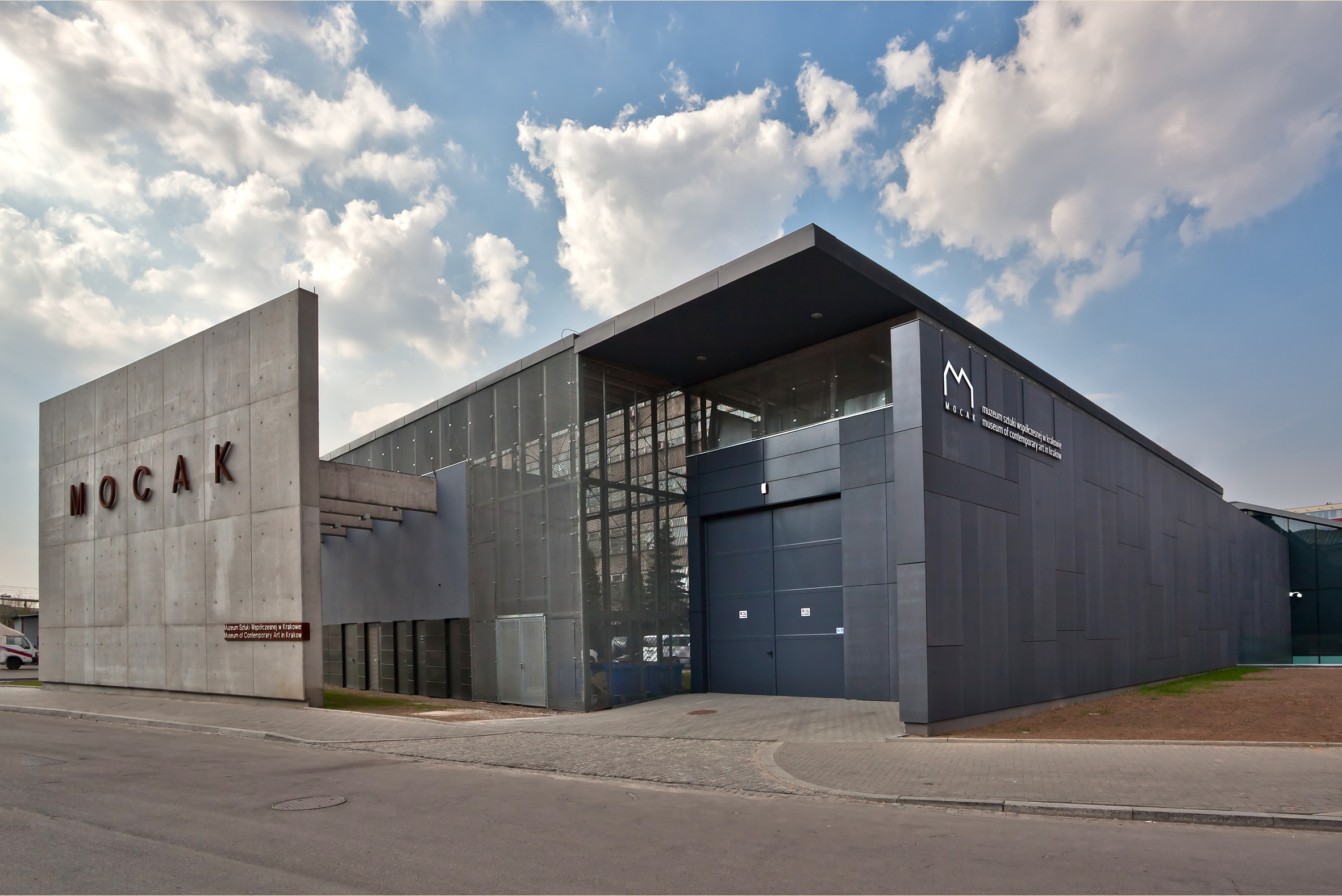
The Museum of Contemporary Art in Kraków (MOCAK),, is a contemporary art gallery in Kraków, Poland that opened on 19 May 2011. Situated 3 kilometres from the centre of the city, on a demolished part of the factory of Oskar Schindler, the aim of the gallery is to present and support contemporary art and artists, in particular art from the last two decades.
87. Piotr Skarga

The Monument of Piotr Skarga in Kraków is a monument to the Jesuit theologian and preacher Piotr Skarga, located on Maria Magdalena Square in Kraków, opposite the Church of St. Peter and Paul, where Skarga is buried. Its author is Czesław Dźwigaj, and the founder is the Archconfraternity of Mercy.
88. Skurwysyn
Skurwysyn – a rock on the Winnica hill in Tyniec. Administratively, it belongs to District VIII Dębniki in Krakow. Geographically, it belongs to the Tyniec Hills on the Kraków Bridge within the macroregion of the Kraków Gate. These hills were included in the area of the Bielańsko-Tyniecki Landscape Park.
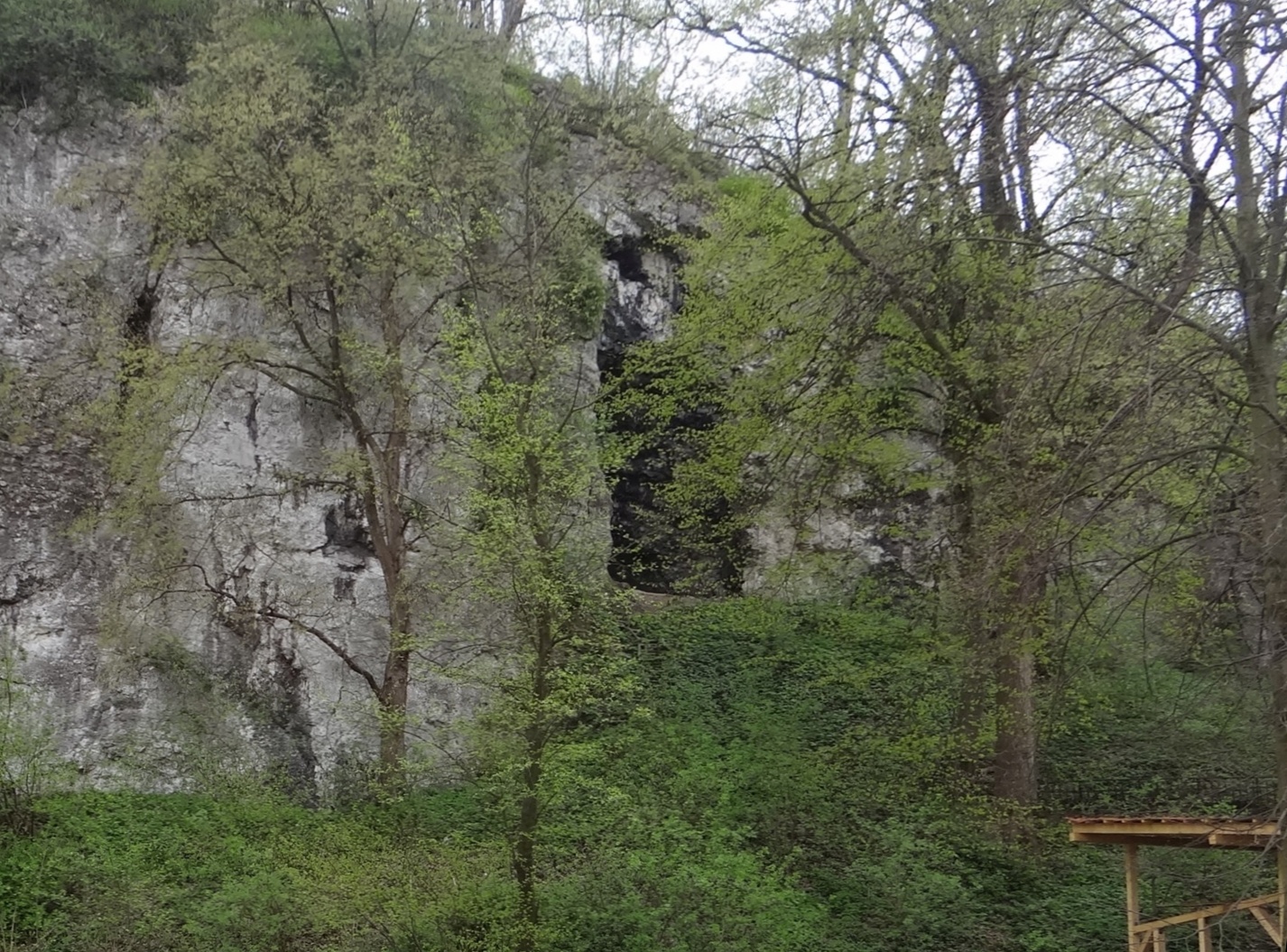
89. Grota Twardowskiego

Twardowski Cave – a large karst cave in District VIII Dębniki in Kraków. It is located on the south-western edge of the Krzemionki Zakrzowskie hill, a short distance from the concrete fence of the Military Unit. A path runs between this fence and the cave opening. The cave is visible from it.
90. Kościół pw. Niepokalanego Serca Najświętszej Marii Panny

The Church of the Immaculate Heart of the Blessed Virgin Mary is a historic Roman Catholic parish church and conventual church of the Felician Sisters located in Krakow, in the Old Town district I at 6 Smoleńsk Street, in Nowy Świat.
Wikipedia: Kościół Niepokalanego Serca Najświętszej Maryi Panny w Krakowie (ul. Smoleńsk) (PL)
91. Muzeum Przyrodnicze PAN

The Museum of Natural History in Krakow is a museum located in Krakow at 9 St. Sebastian Street. There is a prepared, perfectly preserved, prehistoric woolly rhinoceros, the only completely preserved specimen of this animal in the world, extinct over 12 thousand years ago. Since October 2012, it has resumed its activity.
Wikipedia: Muzeum Przyrodnicze Instytutu Systematyki i Ewolucji Zwierząt PAN (PL), Website
92. University Museum

The Jagiellonian University Museum is a museum located in the Collegium Maius building of the Jagiellonian University, at the corner of St. Anne and Jagiellońska Streets in Krakow. It originates from the Archaeological Cabinet of the University, founded in 1867 by Professor Józef Łepkowski, and owes its current shape primarily to Karol Estreicher.
Wikipedia: Muzeum Uniwersytetu Jagiellońskiego (PL), Website
93. Park Ratuszowy

The Town Hall Park is a city park in Kraków, in the XVIII district of Nowa Huta, in the Szklane Domy housing estate, in Nowa Huta. It is bounded from the west by Róż Avenue, from the south by Przyjaźni Avenue, from the east by Edwarda Gardy-Godlewskiego Street, and from the north by Edwarda Rydza-Śmigłego Street, and has an area of 2.2 ha. The park was officially named in 2003, but it existed in this place much earlier – the resolution of the Krakow City Council of 2 July 2003 only legally sanctioned the name commonly used by local residents. The author of the park's design is Bronisław Szulewski.
94. Centrum Kultury Podgórza - Fort Borek

Fort 52 "Borek" – one of the forts of the Kraków Fortress. It was built in the years 1885–1886, it was most likely designed by Daniel Salis-Soglio, and three forts in the Przemyśl Fortress were built on its model. Fort 52 "Borek" belonged to the VIII defensive sector of the Kraków Fortress, covering the areas between the valleys of the Wilga and the upper Vistula. It is a two-rampart artillery fort. The higher rampart was intended for artillery, and the lower one - for infantry and light guns. Caponiers were armed with mithraliezes, and then with machine guns. The fort is the first three-level underground intersection in Krakow for the movement of soldiers and the transport of armaments.
Wikipedia: Fort główny artyleryjski 52 „Borek” (PL), Website
95. Botanical Garden

The Botanic Garden of the Jagiellonian University is a botanical garden, founded in 1783 in Kraków. It is located east of the Old Town and occupies 9.6 hectares. It belongs to the Jagiellonian University and is classified as a historical location.
Wikipedia: Botanic Garden of the Jagiellonian University (EN)
96. Ogród Zoologiczny w Krakowie

The Kraków Zoo is located in Kraków, Poland and was established in 1929. It is home to over 1500 animals and about 260 species. The zoo is a member of the European Association of Zoos and Aquaria and the World Association of Zoos and Aquariums.
97. Kościół pw. Najświętszej Maryi Panny z Lourdes

The Church of the Holy Virgin Mary of Lourdes is a Roman Catholic church in Kraków, Poland, dedicated to Our Lady of Lourdes. It was founded by the Lazarists, and built in 1892–1894 at ul. Misjonarska 37 street in the district of Krowodrza. It has been a parish church since 1923. In interwar Poland, a polyphonic choir was established by the congregation in 1932. The Mariański Choir has attracted international acclaim for a number of years.
Wikipedia: Church of the Holy Virgin Mary of Lourdes (EN), Website
98. Pomnik na Wzgórzu Kaim

The Monument on the Kaim Hill is a historic monument located in Kraków, in the district XII of Bieżanów-Prokocim in the southern part of the former village of Bieżanów, on the western slope of the Kaim Hill, on the border of Kraków and Wieliczka. It commemorates the repulsion of the assault of Russian troops by the Austro-Hungarian army, which took place on December 6, 1914 during the "Second Battle of Krakow" - an important episode of World War I.
99. Grunwald Monument

The Grunwald Monument is an equestrian statue of King of Poland Władysław II Jagiełło (1352–1434) located at Matejko Square in Kraków's Old Town and constructed in 1910 to commemorate the 500th anniversary of the Battle of Grunwald.
100. Kościół Chrześcijan Baptystów w Krakowie

And the church of the Baptist Christian Church in Krakow - belongs to one of the oldest baptist communities in Lesser Poland. His history dates back to 1932 and is associated with the history of congregations in Krynica-Zdrój and Tarnów. In 1932, the first baptism in the Vistula of people belonging to the community was formed at the time, and then a formal constitution of the congregation took place. In the years 1936–1966 the services of Krakow Baptists were held at 10 Dajwór Street, then the community could participate in services in the building at Stanisława Wyspiański Street in the Łobzów district. In 1999 Zbigniew Sobczak became the pastor of the congregation. In 2009, there were 87 baptized members in the congregation. At the end of 2010, one of the institutions and the congregation moved from Nowa Huta to Wieliczka. In the first decade of the 21st century, the congregation also ran its own newspaper entitled "Road". In 1990, the congregation developed social activity, establishing a "smile" children's club, and an evangelistic artistic activity is also conducted. And the Baptist church in Krakow also cooperates with other baptist congregations in Poland and abroad.
Wikipedia: I Zbór Kościoła Chrześcijan Baptystów w Krakowie (PL), Website
Share
How likely are you to recommend us?
Disclaimer Please be aware of your surroundings and do not enter private property. We are not liable for any damages that occur during the tours.