Self-guided Sightseeing Tour #1 in Amsterdam, Netherlands
Legend
Guided Free Walking Tours
Book free guided walking tours in Amsterdam.
Guided Sightseeing Tours
Book guided sightseeing tours and activities in Amsterdam.
Tour Facts
6.4 km
69 m
Experience Amsterdam in Netherlands in a whole new way with our free self-guided sightseeing tour. This site not only offers you practical information and insider tips, but also a rich variety of activities and sights you shouldn't miss. Whether you love art and culture, want to explore historical sites or simply want to experience the vibrant atmosphere of a lively city - you'll find everything you need for your personal adventure here.
Activities in AmsterdamIndividual Sights in AmsterdamSight 1: Nieuwe-Wercksbrug

The Nieuwe-Wercksbrug is a fixed bridge in Amsterdam-Centrum. The bridge connects the Westermarkt with the Rozengracht. It spans the Prinsengracht at the level of the Oude Wester.
Sight 2: Anne Frank
Get Ticket*
The statue of Anne Frank on the Westermarkt in Amsterdam is a statue of the German-Jewish girl Anne Frank who died during the Holocaust at the age of fifteen. Through her diary, Anne Frank has become the symbol of the victims of the Holocaust worldwide.
Sight 3: Homomonument

The Homomonument is a memorial in the centre of Amsterdam, the capital of the Netherlands. It commemorates all gay men and lesbians who have been persecuted because of their sexual orientation. Opened on 5 September 1987, it was the first monument in the world to commemorate gays and lesbians who were killed by the German Nazi regime.
Sight 4: Huis Bartolotti

The Bartolotti House is a canal house at Herengracht 170-172 in Amsterdam. It was built around 1617 for Willem van den Heuvel tot Beichlingen, one of the richest Amsterdammers at the time, who had inherited a lot of money from a childless uncle by marriage, Giovanni Battista Bartolotti, a merchant from Bologna. In this uncle's will, it was stipulated that he had to call himself "Bartolotti". The name is sometimes also "From the Hill to Beichlingen Said Bartolotti". His mother Maria Pels (?-1592) married Willem Bartolotti in Stade in 1589. Her son Jan Baptist Bartolotti van den Heuvel (1590-1624) married Leonora Hellemans Arnoudsdochter (1594-1661) in 1612. In 1639, Jacoba Victoria, daughter of Guillelmo (1602-1658), was born in the house.
Sight 5: Brug 6

Bridge 6 is a fixed bridge in the centre of Amsterdam. The road bridge connects the Paleisstraat with the Gasthuismolensteeg. In doing so, it spans the Singel. To the southeast of the bridge is the Bungehuis.
Sight 6: Huiszittenbrug

Bridge 8 is the official designation of a bridge in the centre of Amsterdam. Until 5 July 2016, the bridge had the unofficial name Huiszitbrug, which referred to the Huiszitpakhuis. However, this name has been dropped.
Sight 7: New Church

The Nieuwe Kerk is a 15th-century church in Amsterdam located on Dam Square, next to the Royal Palace. Formerly a Dutch Reformed Church parish, it now belongs to the Protestant Church in the Netherlands.
Sight 8: Dam Square Victims 7 mei 1945

A plaque and thirty-two paving stones on the Dam in Amsterdam-Centrum commemorate the victims of the Shooting on the Dam on May 7, 1945.
Wikipedia: Monument voor Damslachtoffers 7 mei 1945 (NL), Website
Sight 9: Dam Square
Get Ticket*
Dam Square or the Dam is a town square in Amsterdam, the capital and most populated city of the Netherlands. Its notable buildings and frequent events make it one of the best-known and most important locations in the city and the country.
Sight 10: Normaal Amsterdams Peil

Amsterdam Ordnance Datum or Normaal Amsterdams Peil (NAP) is a vertical datum in use in large parts of Western Europe. Originally created for use in the Netherlands, its height was used by Prussia in 1879 for defining Normalnull, and in 1955 by other European countries. In the 1990s, it was used as the reference level for the United European leveling Network (UELN) which in turn led to the European Vertical Reference System (EVRS).
Sight 11: De Papegaai

De Papegaai is the lesser of the two parochial churches in the St Nicholas Roman Catholic parish in Amsterdam. The church is dedicated to Saints Peter and Paul. It is nicknamed "De Papegaai" because it was originally hidden in a garden behind a regular housefront that belonged to a bird-trader in the days when Catholicism could not be practised publicly. Today there is a narrow, Neo-Gothic facade flanked by statues of St Joseph and a perched parrot. The church is on the busy Kalverstraat just south of Dam Square, and invites people in for quiet, as well as celebrating Sunday Mass in Latin with Gregorian chant.
Wikipedia: Church of St. Peter and St. Paul, Amsterdam (EN), Website
Sight 12: Madame Tussauds Amsterdam
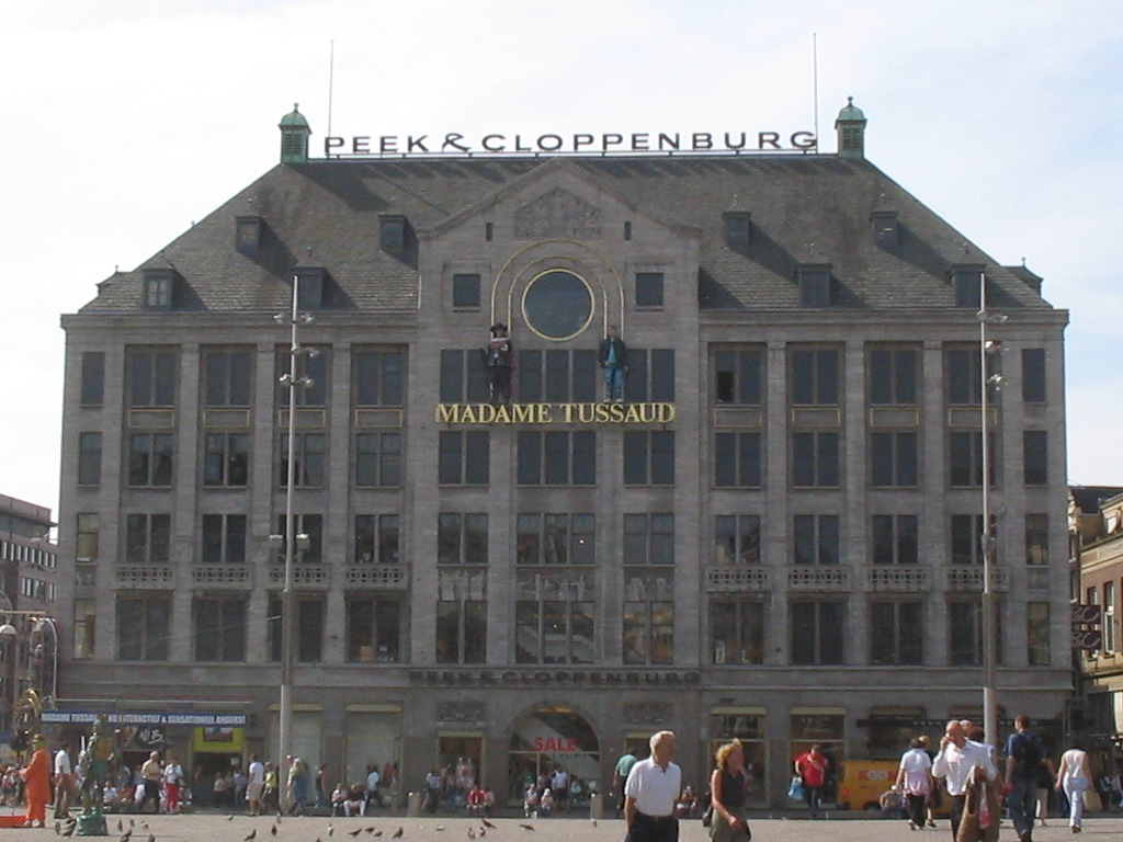
Madame Tussauds Amsterdam is a wax museum situated in Amsterdam, the capital city of the Netherlands. It is located in the centre of the city on Dam Square, near the Royal Palace of Amsterdam. Founded in 1970, it was the first Madame Tussauds that was opened in mainland Europe as well as being the first foreign branch of the British institution. The collection of Madame Tussauds Amsterdam consists of a collection of wax figures of famous celebrities in different categories such as the Golden Age of Dutch history, music, sport and film.
Sight 13: Rokinfontein

The Rokin Fountain is a work of art in the shape of a fountain in the center of Amsterdam. The work is part of the major redevelopment of the city center under the name The Red Carpet.
Sight 14: National Monument
Get Ticket*
The National Monument on Dam Square is a 1956 cenotaph in Amsterdam, Netherlands. A national Remembrance of the Dead ceremony is held at the monument every year on 4 May to commemorate the casualties of World War II and subsequent armed conflicts.
Sight 15: Canal Ring Area of Amsterdam

The Grachtengordel, known in English as the Canal District, is a neighborhood in Amsterdam, Netherlands located in the Centrum district. The seventeenth-century canals of Amsterdam, located in the center of Amsterdam, were added to the UNESCO World Heritage List in August 2010. The Amsterdam Canal District consists of the area around the city's four main canals: the Singel, the Herengracht, the Keizersgracht, and the Prinsengracht. From the Brouwersgracht, the canals are generally parallel with one another, leading gradually southeast into the Amstel river.
Sight 16: Hash Marihuana & Hemp Museum

The Hash, Marihuana & Hemp Museum is a museum located in De Wallen, Amsterdam, Netherlands. According to the museum, more than two million visitors have visited the exhibition since it opened in 1985. Dedicated to cannabis and its many uses, the museum offers visitors information about the historical and modern uses of cannabis for medicinal, spiritual and cultural purposes. The museum also focuses on how hemp can be used for agricultural and industrial purposes, even including clothing accessories and cosmetic products made from hemp fiber. In 2012 the museum opened a second location in Barcelona, the Hash Marihuana Cáñamo & Hemp Museum.
Sight 17: Cannabis College

The Cannabis College is a non-profit information centre located in the centre of Amsterdam's historic Red Light District in The Netherlands. Opened in 1998, the info centre features displays of the many and varied uses for Cannabis sativa and industrial hemp, as well as the history of human interaction with the plant. Everything from hemp building materials and plastics to medical Cannabis and worldwide legislation is covered.
Sight 18: Walloon Church

The Walloon Church is a Protestant church building in Amsterdam, along the southern stretch of the Oudezijds Achterburgwal canal. The building dates to the late 15th century and has been in use as a Walloon church since 1586. The church was also known as the Franse Kerk, Walenkerk, Oude Walenkerk, or Oude Waalse Kerk.
Sight 19: Trippenhuis

The Trippenhuis is a neoclassical canal mansion in the centre of Amsterdam. It was built in 1660–1662 for the wealthy Amsterdam weapons traders Louis and Hendrick Trip. Many references to weaponry can be seen on its facade. Since 1887 it has been the seat of the Royal Netherlands Academy of Arts and Sciences (KNAW).
Sight 20: Waag
Get Ticket*
The Waag is a 15th-century building on Nieuwmarkt square in Amsterdam. It was originally a city gate and part of the walls of Amsterdam. Later it served as a guildhall, museum, fire station and anatomical theatre, among other things.
Sight 21: Bredero

The Bredero monument is a work of art in the centre of Amsterdam.
Sight 22: Chinatown
Get Ticket*
Chinatown is the Chinese neighborhood of Amsterdam. The neighborhood is located around the Geldersekade and Zeedijk in the old city center (Amsterdam-Centrum).
Sight 23: Montelbaanstoren
Get Ticket*The Montelbaanstoren is a tower on bank of the Oudeschans – a canal in Amsterdam. The original tower was built in 1516 as part of the Walls of Amsterdam for the purpose of defending the city and the harbour. The top half, designed by Hendrick de Keyser, was extended to its current, decorative form in 1606. Since then the tower has been 48m tall.
Sight 24: Scheepvaarthuis

The Shipping House is a building on the western tip of the Waalseiland near Amsterdam harbour that is one of the top 100 Dutch heritage sites and generally regarded as the first true example of the Amsterdam School, a style characterised by "expressive dynamism, lavish ornamentation and colourful embellishments". It is situated on the Prins Hendrikkade and was erected on the spot where Cornelis Houtman's first trip to the East Indies had begun in 1595. The first part was built 1913 - 1916 ; the second part was built 1926 -1928. Originally, it was the headquarters of six leading Amsterdam shipping companies: the Netherlands Steamship Company (SMN), the Royal Packet Navigation Company (KPM), the Java-China-Japan Line (JCJL) and the Royal Dutch Steamboat Company (KNSM) with subsidiary New Rhine Navigation Company (NRM) and acquired in 1912 Royal West India Mail Service (KWIM).
Sight 25: Weepers' Tower

The Schreierstoren, originally part of the medieval city wall of Amsterdam, the Netherlands, was built in the 15th century. It is located at the Prins Hendrikkade 94 in the city center of Amsterdam. It was the location from which Henry Hudson set sail on his journey to Northern America. This expedition would lead to the discovery of the modern New York metropolitan area, which laid the foundation for Dutch colonization of the region. It was built as a defense tower in 1487. It is currently a café and nautical bookstore.
Sight 26: Sint Nicolaaskerk

The Basilica of Saint Nicholas is located in the Old Centre district of Amsterdam, Netherlands, very close to Amsterdam's main railway station. St, Nicholas is the patron saint of both the church and the city of Amsterdam. The basilica is the city's primary Roman Catholic church.
Wikipedia: Basilica of Saint Nicholas, Amsterdam (EN), Website
Sight 27: Sint Olofskapel

St. Olof's Chapel, or Oudezijds Chapel, is a building in the Dutch city of Amsterdam. The former church building is located in the city center of Amsterdam, between the Zeedijk and the Nieuwebrugsteeg, near the Damrak. The first St. Olof's Chapel was built between 1440 and 1450 against a large city gate, the St. Olof's Gate. In 1618 the gatehouse was demolished, but the former passage is still called "Sint Olofspoort". Patron saint was "Saint Olof".
Sight 28: Fo Guang Sha He Hua Temple

Fo Guang Shan He Hua Temple (Chinese: 佛光山荷華寺; pinyin: Fó Guāng Shān Hé Huá Sì; lit. 'Buddha's Light Mountain Lotus Flower Temple', or simply He Hua Temple, is a Buddhist temple located at Zeedijk 106–118, Chinatown in Amsterdam. It is the largest Buddhist temple built in the traditional Chinese palace style in Europe. The temple is part of the Fo Guang Shan, and the BLIA. It is also the first Chinese Buddhist temple building in Europe.
Sight 29: Red Light District
Get Ticket*
De Wallen is the largest and best known red-light district in Amsterdam. It consists of a network of alleys containing approximately 300 one-room cabins rented by prostitutes who offer their sexual services from behind a window or glass door, typically illuminated with red lights and blacklight. Window prostitution is the most visible and typical kind of red-light district sex work in Amsterdam.
Sight 30: Borstplaat

Breastplate and The caressed breast are fictitious names of a relief in the centre of Amsterdam.
Sight 31: Ons' Lieve Heer op Solder

Ons' Lieve Heer op Solder is a 17th-century canal house, house church, and museum in the city center of Amsterdam, The Netherlands. The Catholic Church was built on the top three floors of the canal house during the 1660s. It is an important example of a "schuilkerk", or "clandestine church" in which Catholics and other religious dissenters from the seventeenth century Dutch Reformed Church, unable to worship in public, held services. The church has been open as a museum since 28 April 1888, and has 85,000 visitors annually.
Sight 32: Warmoesstraat

Warmoesstraat is one of the oldest streets in Amsterdam, running parallel to Damrak from Nieuwebrugsteeg to Dam Square. Its origins are in the 13th century. In the 16th and 17th century it was the shopping street. During the Dutch Golden Age, the father of legendary poet and playwright Joost van den Vondel ran a business as a silk merchant there.
Sight 33: Prostitution Information Centre

The Prostitution Information Centre is located in the heart of Amsterdam in the red light district, near Amsterdam's Old Church. The PIC serves as an educational centre and resource for providing Amsterdam's visitors with information and advice about prostitution.
Sight 34: Old Church
Get Ticket*
The Oude Kerk is Amsterdam's oldest building and newest art institute. The building was founded about 1213 and consecrated in 1306 by the bishop of Utrecht with Saint Nicolas as its patron saint. After the Reformation in 1578, it became a Calvinist church, which it remains today. It stands in De Wallen, now Amsterdam's main red-light district. The square surrounding the church is the Oudekerksplein.
Sight 35: Beurs van Berlage
Get Ticket*
The Beurs van Berlage is a building on the Damrak, in the centre of Amsterdam. It was designed as a commodity exchange by architect Hendrik Petrus Berlage and constructed between 1896 and 1903. It influenced many modernist architects, in particular functionalists and the Amsterdam School. It is now used as a venue for concerts, exhibitions and conferences.
Sight 36: Sexmuseum
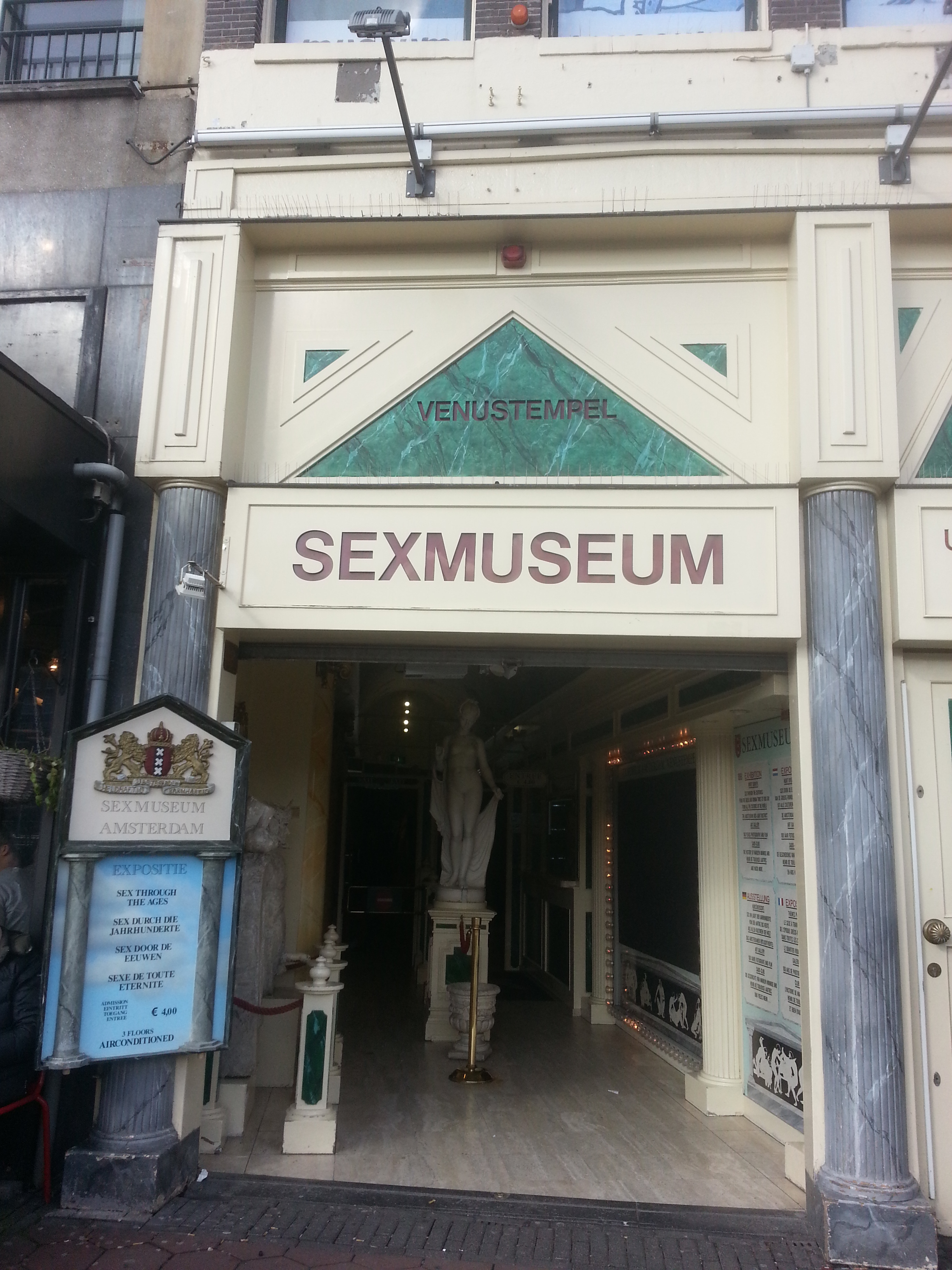
The Sexmuseum or the Temple of Venus is a sex museum located in Amsterdam, Netherlands. The museum was opened in 1985. It had 675,000 visitors in 2015, making it one of the most visited museums in the Netherlands.
Sight 37: Annick van Hardeveld

The Monument to Annick van Hardeveld is a war memorial in the centre of Amsterdam. The monument in the form of a bluestone pedestal with a plaque has been placed on the Hekelveld, in front of the building that bears house number 25. It was designed by the artist Hans Bayens.
Share
How likely are you to recommend us?
Disclaimer Please be aware of your surroundings and do not enter private property. We are not liable for any damages that occur during the tours.
GPX-Download For navigation apps and GPS devices you can download the tour as a GPX file.