Self-guided Sightseeing Tour #6 in Jerusalem, Israel
Legend
Guided Free Walking Tours
Book free guided walking tours in Jerusalem.
Guided Sightseeing Tours
Book guided sightseeing tours and activities in Jerusalem.
Tour Facts
5.9 km
273 m
Experience Jerusalem in Israel in a whole new way with our free self-guided sightseeing tour. This site not only offers you practical information and insider tips, but also a rich variety of activities and sights you shouldn't miss. Whether you love art and culture, want to explore historical sites or simply want to experience the vibrant atmosphere of a lively city - you'll find everything you need for your personal adventure here.
Activities in JerusalemIndividual Sights in JerusalemSight 1: קבר אחים חללי הרובע היהודי

The Mass Grave for the Fallen of the Jewish Quarter is a mass grave on the Mount of Olives, near the Tombs of the Prophets, in Jerusalem, where 48 of the fallen soldiers of the Jewish Quarter who were killed in the War of Independence are buried.
Sight 2: Tomb of Zacharias

The Tomb of Zechariah is an ancient stone monument in Jerusalem that is considered in Jewish tradition to be the tomb of Zechariah ben Jehoiada. It is a few meters from the Tomb of Absalom and adjacent to the Tomb of Benei Hezir.
Sight 3: Monolith of Silwan

The Monolith of Silwan, also known as the Tomb of Pharaoh's Daughter, is a cuboid rock-cut tomb located in the Kidron Valley, in Silwan, Jerusalem dating from the period of the Kingdom of Judah. The Tomb of Pharaoh's Daughter refers to a 19th-century hypothesis that the tomb was built by Solomon for his wife, the Pharaoh's daughter. The structure, a typical Israelite rock-cut tomb, was previously capped by a pyramid structure like the Tomb of Zechariah. The upper edges of the monolith are fashioned in the shape of an Egyptian cornice. The pyramidal rock cap was cut into pieces and removed for quarry during the Roman era, leaving a flat roof. The tomb contains a single stone bench, indicating that it was designed for only one burial. Recent research indicates that the bench was the base of a sarcophagus hewn into the original building.
Sight 4: Tomb of the Sons of Hezir

The Tomb of Benei Hezir, previously known as the Tomb of Saint James, is the oldest of four monumental rock-cut tombs that stand in the Kidron Valley, adjacent to the Tomb of Zechariah and a few meters from the Tomb of Absalom. It dates to the period of the Second Temple. It is a complex of burial caves. The tomb was originally accessed from a single rock-cut stairwell which descends to the tomb from the north. At a later period an additional entrance was created by quarrying a tunnel from the courtyard of the monument known as "the Tomb of Zechariah". This is also the contemporary entrance to the burial complex.
Sight 5: Hulda Tripple Gate

The Huldah Gates were one of the Gates of the Old City of Jerusalem leading into the Jerusalem Temple compound in the Hasmonean period and were named as such in the Mishnah. The term is currently being used for the remains of two later sets of gates, the Triple Gate and the Double Gate, known together as the Huldah Gates, built as part of the much extended Herodian Temple Mount, situated in Jerusalem's Old City. Both sets of gates were set into the Southern Wall of the Temple compound and gave access to the Temple Mount esplanade by means of underground vaulted ramps. Both were walled up in the Middle Ages.
Sight 6: Al-Aqsa Mosque
Get Ticket*
Al-Aqsa or al-Masjid al-Aqṣā is the compound of Islamic religious buildings that sit atop the Temple Mount, also known as the Haram al-Sharif, in the Old City of Jerusalem, including the Dome of the Rock, many mosques and prayer halls, madrasas, zawiyas, khalwas and other domes and religious structures, as well as the four encircling minarets. It is considered the third holiest site in Islam. The compound's main congregational mosque or prayer hall is variously known as Al-Aqsa Mosque, Qibli Mosque or al-Jāmiʿ al-Aqṣā, while in some sources it is also known as al-Masjid al-Aqṣā; the wider compound is sometimes known as Al-Aqsa Mosque compound in order to avoid confusion.
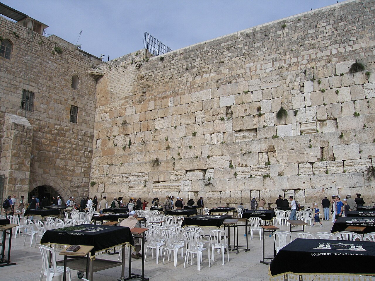
Sight 7: Western Wall
Get Ticket*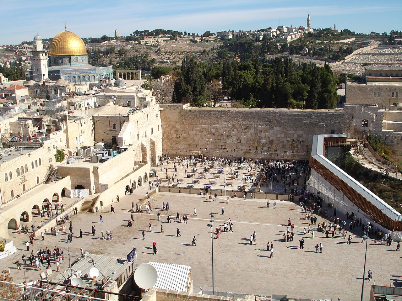
The Western Wall (Hebrew: הַכּוֹתֶל הַמַּעֲרָבִי, romanized: HaKotel HaMa'aravi, lit. 'the western wall', is an ancient retaining wall of the built-up hill known to Jews and Christians as the Temple Mount of Jerusalem. Its most famous section, known by the same name, often shortened by Jews to the Kotel or Kosel, is known in the West as the Wailing Wall, and in Islam as the Buraq Wall. In a Jewish religious context, the term Western Wall and its variations is used in the narrow sense, for the section used for Jewish prayer; in its broader sense it refers to the entire 488-metre-long retaining wall on the western side of the Temple Mount.
Sight 8: Solomon's Stables

Solomon's Stables, or Al-Marwani Mosque, is an underground vaulted prayer hall in the Al-Aqsa mosque compound in Jerusalem. It is 600 square yards in area, and is located under the southeastern corner of the compound, 12.5 m (41 ft) below the courtyard, and features twelve rows of pillars and arches. In December 1996 the Jerusalem Waqf renovated the area. The area was known to the Crusaders as Solomon's Stables, and to earlier Muslims as the Old Mosque.
Sight 9: Ohel Yitzchak Synagogue

The Ohel Yitzchak Synagogue, also known as the Shomrei ha-Chomos Synagogue and the Ungarin Shul, is an Orthodox Jewish congregation and synagogue, located in the Muslim Quarter of the Old City of Jerusalem, Israel. It was built as a yeshiva in the 1870s by Kolel Shomrei HaChomos, an organization of Hungarian Jews, but was abandoned after the riots of 1938. Although the building was destroyed after 1948, it was reopened in October 2008 after acquisition by a Religious Zionist group and subsequent refurbishment.
Sight 10: Wilson's Arch prayer hall
Wilson's Arch is the modern name for an ancient stone arch in Jerusalem, the first in a row of arches that supported a large bridge connecting the Herodian Temple Mount with the Upper City on the opposite Western Hill. The Arch springs from the Western Wall and is still visible underneath later buildings set against the Wall. The name Wilson's Arch is also used to denote the hall that it partially covers, which is currently used as a synagogue. This hall opens towards the Western Wall Plaza at the Plaza's northeast corner, so that it appears on the left of the prayer section of the Western Wall to visitors facing the Wall.
Sight 11: Yeshivat HaKotel

Porat Yosef Yeshiva is a Sephardic yeshiva in Jerusalem, with locations in both the Old City and the Geula neighborhood. The name Porat Yosef means "Joseph is a fruitful tree" after the biblical verse Genesis 49:22.
Sight 12: Dung Gate
Get Ticket*
The Dung Gate, also known in Arabic as the Silwan Gate and Mughrabi Gate, is one of the Gates of the Old City of Jerusalem. It was built as a small postern gate in the 16th century by the Ottomans, first widened for vehicular traffic in 1952 by the Jordanians, and again in 1985 by the Israeli authorities. The Dung Gate is a main passage for vehicles coming out of the Old City and for buses headed to the Western Wall.
Sight 13: St. Peter of Gallicantu

Church of Saint Peter in Gallicantu is a Roman Catholic church located on the eastern slope of Mount Zion, just outside the walled Old City of Jerusalem. It is dedicated to the episode from the New Testament known as the Denial of Peter.
Sight 14: Mount Zion
Get Ticket*
Mount Zion is a hill in Jerusalem, located just outside the walls of the Old City to the south. The term Mount Zion has been used in the Hebrew Bible first for the City of David and later for the Temple Mount, but its meaning has shifted and it is now used as the name of ancient Jerusalem's Western Hill. In a wider sense, the term Zion is also used for the entire Land of Israel.
Sight 15: David's Tomb
Get Ticket*
David's Tomb is a site that, according to a Medieval tradition, is associated with the burial of the biblical King David. Historians, archaeologists and Jewish religious authorities do not consider the site to be the actual resting place of King David. It occupies the ground floor of a former church, whose upper floor holds the Cenacle or "Upper Room" traditionally identified as the place of Jesus' Last Supper and the original meeting place of the early Christian community of Jerusalem.
Sight 16: Cenacle
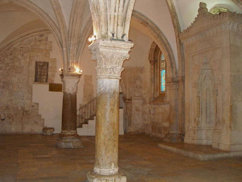
The Cenacle, also known as the Upper Room, is a room in Mount Zion in Jerusalem, just outside the Old City walls, traditionally held to be the site of the Last Supper, the final meal that, in the Gospel accounts, Jesus held with the apostles.
Share
How likely are you to recommend us?
Disclaimer Please be aware of your surroundings and do not enter private property. We are not liable for any damages that occur during the tours.
GPX-Download For navigation apps and GPS devices you can download the tour as a GPX file.