76 Sights in Jerusalem, Israel (with Map and Images)
Legend
Premium Sights
Book tickets, guided tours and activities in Jerusalem.
Guided Free Walking Tours
Book free guided walking tours in Jerusalem.
Welcome to your journey through the most beautiful sights in Jerusalem, Israel! Whether you want to discover the city's historical treasures or experience its modern highlights, you'll find everything your heart desires here. Be inspired by our selection and plan your unforgettable adventure in Jerusalem. Dive into the diversity of this fascinating city and discover everything it has to offer.
Sightseeing Tours in JerusalemActivities in Jerusalem
Gethsemane is a garden at the foot of the Mount of Olives in East Jerusalem, where, according to the four Gospels of the New Testament, Jesus Christ underwent the Agony in the Garden and was arrested before his crucifixion. It is a place of great resonance in Christianity. There are several small olive groves in church property, all adjacent to each other and identified with biblical Gethsemane.

The Church of All Nations, also known as the Church of Gethsemane or the Basilica of the Agony, is a Catholic church located on the Mount of Olives in East Jerusalem, next to the Garden of Gethsemane. It enshrines a section of bedrock where Jesus is said to have prayed before his arrest.

The Dung Gate, also known in Arabic as the Silwan Gate and Mughrabi Gate, is one of the Gates of the Old City of Jerusalem. It was built as a small postern gate in the 16th century by the Ottomans, first widened for vehicular traffic in 1952 by the Jordanians, and again in 1985 by the Israeli authorities. The Dung Gate is a main passage for vehicles coming out of the Old City and for buses headed to the Western Wall.

The Pool of Bethesda is referred to in John's Gospel in the Christian New Testament, in an account of Jesus healing a paralyzed man at a pool of water in Jerusalem, described as being near the Sheep Gate and surrounded by five covered colonnades or porticoes. It is also referred to as Bethzatha. It is now associated with the site of a pool in the current Muslim Quarter of the city, near the gate now called the Lions' Gate or St. Stephen's Gate and the Church of St. Anne, which was excavated in the late 19th century.

Dominus Flevit is a Roman Catholic church on the Mount of Olives, opposite the walls of the Old City of Jerusalem in Israel. During construction of the sanctuary, archaeologists uncovered artifacts dating back to the Canaanite period, as well as tombs from the Second Temple and Byzantine eras.

David's Tomb is a site that, according to a Medieval tradition, is associated with the burial of the biblical King David. Historians, archaeologists and Jewish religious authorities do not consider the site to be the actual resting place of King David. It occupies the ground floor of a former church, whose upper floor holds the Cenacle or "Upper Room" traditionally identified as the place of Jesus' Last Supper and the original meeting place of the early Christian community of Jerusalem.
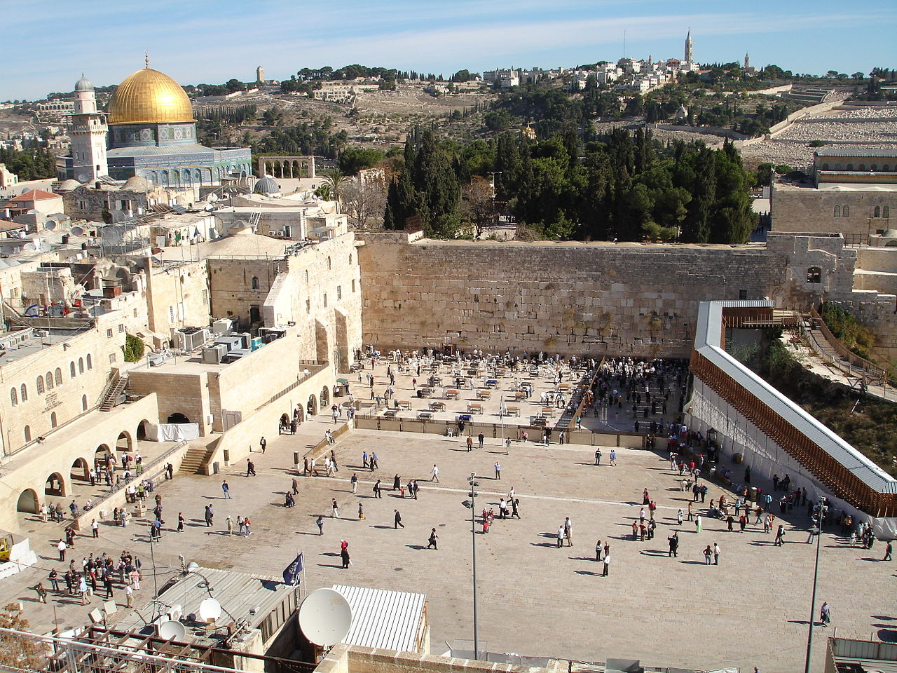
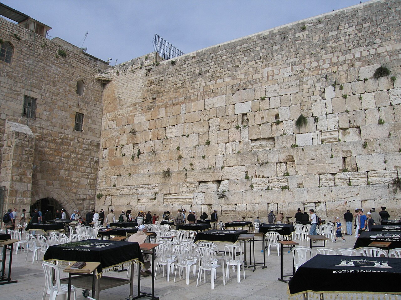
The Western Wall (Hebrew: הַכּוֹתֶל הַמַּעֲרָבִי, romanized: HaKotel HaMa'aravi, lit. 'the western wall', is an ancient retaining wall of the built-up hill known to Jews and Christians as the Temple Mount of Jerusalem. Its most famous section, known by the same name, often shortened by Jews to the Kotel or Kosel, is known in the West as the Wailing Wall, and in Islam as the Buraq Wall. In a Jewish religious context, the term Western Wall and its variations is used in the narrow sense, for the section used for Jewish prayer; in its broader sense it refers to the entire 488-metre-long retaining wall on the western side of the Temple Mount.
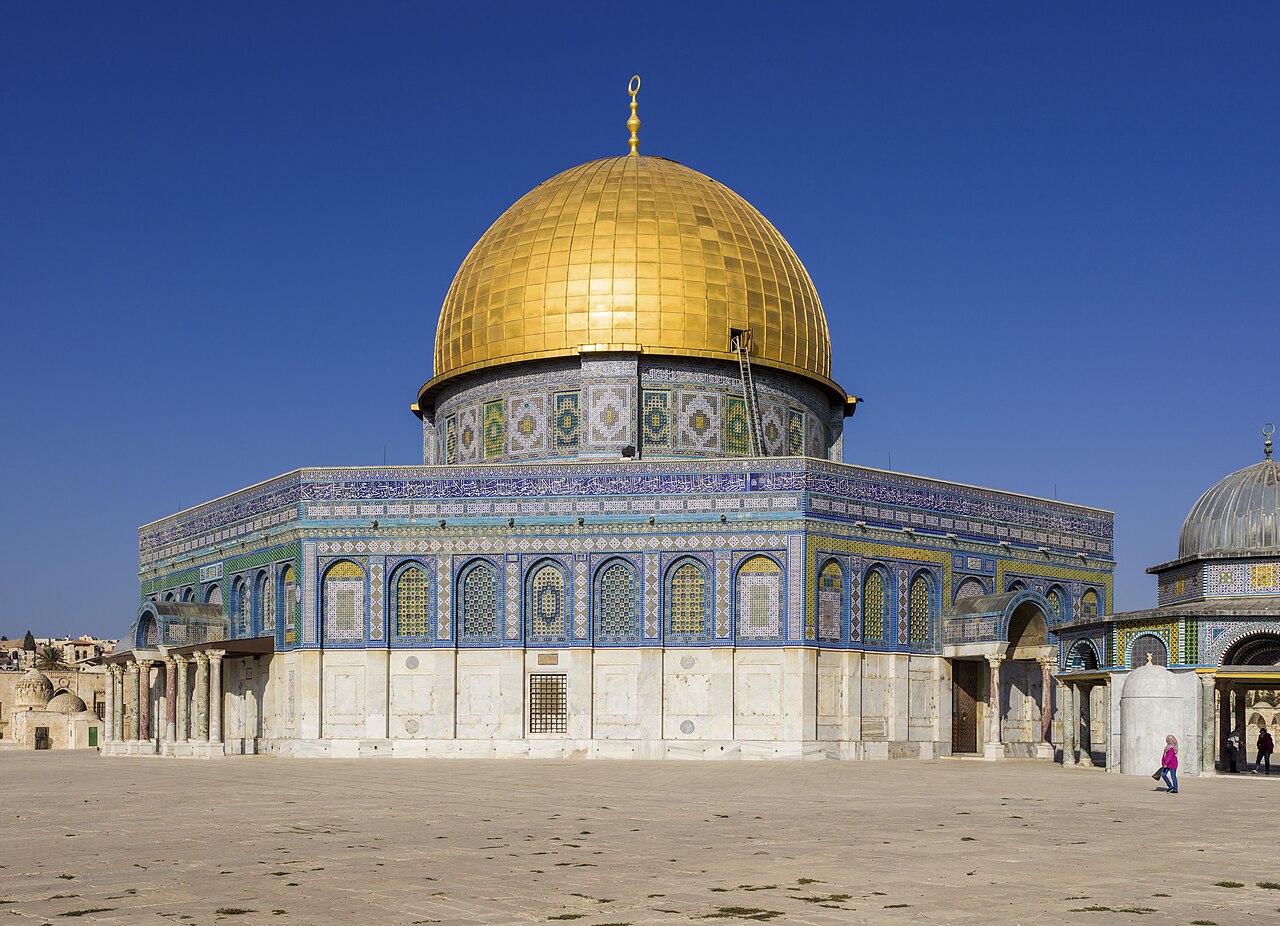
The Dome of the Rock is an Islamic shrine at the center of the Al-Aqsa mosque compound on the Temple Mount in the Old City of Jerusalem. It is the world's oldest surviving work of Islamic architecture, the earliest archaeologically attested religious structure to be built by a Muslim ruler and its inscriptions contain the earliest epigraphic proclamations of Islam and of the Islamic prophet Muhammad.

The Church of the Holy Sepulchre, also known as the Church of the Resurrection, is a fourth-century church in the Christian Quarter of the Old City of Jerusalem. The church is also the seat of the Greek Orthodox Patriarchate of Jerusalem. Some consider it the holiest site in Christianity and it has been an important pilgrimage site for Christians since the fourth century.

Al-Aqsa or al-Masjid al-Aqṣā is the compound of Islamic religious buildings that sit atop the Temple Mount, also known as the Haram al-Sharif, in the Old City of Jerusalem, including the Dome of the Rock, many mosques and prayer halls, madrasas, zawiyas, khalwas and other domes and religious structures, as well as the four encircling minarets. It is considered the third holiest site in Islam. The compound's main congregational mosque or prayer hall is variously known as Al-Aqsa Mosque, Qibli Mosque or al-Jāmiʿ al-Aqṣā, while in some sources it is also known as al-Masjid al-Aqṣā; the wider compound is sometimes known as Al-Aqsa Mosque compound in order to avoid confusion.

Mount Zion is a hill in Jerusalem, located just outside the walls of the Old City to the south. The term Mount Zion has been used in the Hebrew Bible first for the City of David and later for the Temple Mount, but its meaning has shifted and it is now used as the name of ancient Jerusalem's Western Hill. In a wider sense, the term Zion is also used for the entire Land of Israel.

The Cardo was a central north-south oriented thoroughfare in Jerusalem during the Late Roman and Byzantine periods. Together with the east-west oriented Decumanus, it reflects typical Roman city planning. The term "Cardo" derives from the Latin word for "hinge," referring to role as the main north–south axis in Roman cities.
13. Mount of Olives Information Center

The Mount of Olives or Mount Olivet is a mountain ridge in East Jerusalem, east of and adjacent to Jerusalem's Old City. It is named for the olive groves that once covered its slopes. The southern part of the mount was the Silwan necropolis, attributed to the elite of the ancient Kingdom of Judah. The western slopes of the mount, those facing Jerusalem, have been used as a Jewish cemetery for over 3,000 years and holds approximately 150,000 graves, making it central in the tradition of Jewish cemeteries. Atop the hill lies the Palestinian neighbourhood of At-Tur, a former village that is now part of East Jerusalem.
14. ישיבת מיר

The Mir Yeshiva, known also as The Mir, is an Orthodox Jewish yeshiva in Beit Yisrael, Jerusalem. With over 9,000 single and married students, it is the largest yeshiva in the world. Most students are from Israel and the United States, with many from other parts of the world such as Belgium, France, the United Kingdom, Mexico, Switzerland, Argentina, Australia, Russia, Canada and Panama.
15. Tomb of the Virgin Mary

Church of the Sepulchre of Saint Mary, also Tomb of the Virgin Mary (Hebrew: קבר מרים; or the Church of the Assumption, is a Christian church built around an ancient Judean rock-cut tomb in the Kidron Valley – at the foot of Mount of Olives, in East Jerusalem – believed by Eastern Christians to be the burial place of Mary, the mother of Jesus. The Status Quo, a 250-year old understanding between religious communities, applies to the site.
16. Cenacle
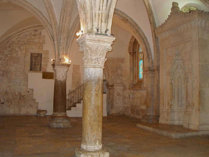
The Cenacle, also known as the Upper Room, is a room in Mount Zion in Jerusalem, just outside the Old City walls, traditionally held to be the site of the Last Supper, the final meal that, in the Gospel accounts, Jesus held with the apostles.
17. HaShiliach Pool

The term Pool of Siloam refers to a number of rock-cut pools, located outside the walls of the Old City of Jerusalem to the southeast. The pools were fed by the waters of the Gihon Spring, carried there by the Siloam Tunnel.
18. Damascus Gate
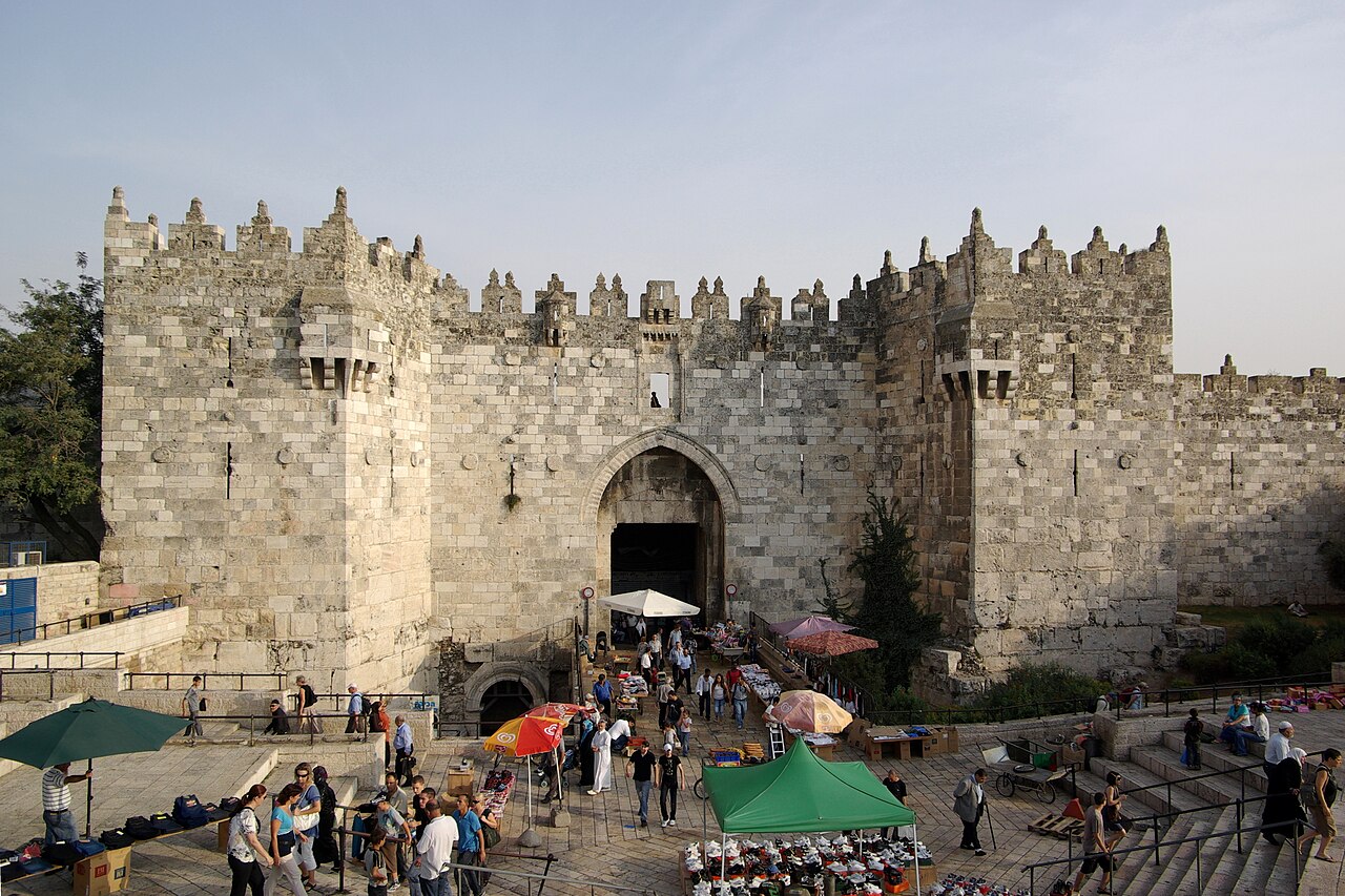
The Damascus Gate is one of the main Gates of the Old City of Jerusalem. It is located in the wall on the city's northwest side and connects to a highway leading out to Nablus, which in the Hebrew Bible was called Shechem or Sichem, and from there, in times past, to the capital of Syria, Damascus; as such, its modern English name is the Damascus Gate, and its modern Hebrew name is Sha'ar Shkhem, meaning Shechem Gate, or in modern terms Nablus Gate. Of its historic Arabic names, Bāb al-Naṣr means "gate of victory", and the current one, Bāb al-ʿĀmūd, means "gate of the column". The latter, in use continuously since at least as early as the 10th century, preserves the memory of a Roman column towering over the square behind the gate and dating to the 2nd century AD.
19. Yeshivat Mercaz HaRav

Mercaz HaRav is a national-religious yeshiva in Jerusalem, founded in 1924 by Ashkenazi Chief Rabbi Abraham Isaac Kook. Located in the city's Kiryat Moshe neighborhood, it has become the most prominent religious-Zionist yeshiva in the world and synonymous with Rabbi Kook's teachings. Many Religious Zionist educators and leaders have studied at Mercaz HaRav.
20. Jerusalem Biblical Zoo

The Tisch Family Biblical Zoo in Jerusalem, popularly known as the Jerusalem Biblical Zoo, is a zoo located in the Malha neighborhood of Jerusalem. It is famous for its Afro-Asiatic collection of wildlife, many of which are described in the Hebrew Bible, as well as for its success in breeding endangered species. According to Dun and Bradstreet, the Biblical Zoo was the most popular tourist attraction in Israel from 2005 to 2007, and logged a record 738,000 visitors in 2009. The zoo had about 55,000 members in 2009.
21. Solomon's Stables

Solomon's Stables, or Al-Marwani Mosque, is an underground vaulted prayer hall in the Al-Aqsa mosque compound in Jerusalem. It is 600 square yards in area, and is located under the southeastern corner of the compound, 12.5 m (41 ft) below the courtyard, and features twelve rows of pillars and arches. In December 1996 the Jerusalem Waqf renovated the area. The area was known to the Crusaders as Solomon's Stables, and to earlier Muslims as the Old Mosque.
22. Ateret Cohanim Yeshiva

Ateret Cohanim, also Ateret Yerushalayim, is an Israeli Jewish organization with a yeshiva located in the Muslim Quarter of the Old City of Jerusalem. It supports the creation of a Jewish majority in the Old City and in Arab neighborhoods in East Jerusalem. Notable alumni of the yeshiva include Rabbi Nissan Ben-Avraham and Rabbi Eyal Karim.
23. Wilson's Arch prayer hall
Wilson's Arch is the modern name for an ancient stone arch in Jerusalem, the first in a row of arches that supported a large bridge connecting the Herodian Temple Mount with the Upper City on the opposite Western Hill. The Arch springs from the Western Wall and is still visible underneath later buildings set against the Wall. The name Wilson's Arch is also used to denote the hall that it partially covers, which is currently used as a synagogue. This hall opens towards the Western Wall Plaza at the Plaza's northeast corner, so that it appears on the left of the prayer section of the Western Wall to visitors facing the Wall.
24. Knesset Menorah

The Knesset Menorah is a bronze menorah that is 4.30 meters high and 3.5 meters wide and weighs 4 tons. It is located at the edge of Wohl Rose Park opposite the Knesset in Jerusalem. It was designed by Benno Elkan (1877–1960), a Jewish sculptor who escaped from his native Germany to the United Kingdom. It was presented to the Knesset as a gift from the British Parliament on April 15, 1956, in honour of the eighth anniversary of Israeli independence.
25. Dome of the Chain

Dome of the Chain is an Islamic free-standing domed building located adjacently east of the Dome of the Rock in the al-Aqsa Mosque compound in the Old City of Jerusalem. It is one of many small buildings that can be found scattered around the Al Aqsa Mosque. Its exact historical use and significance are under scholarly debate. Erected in 691–92 CE, the Dome of the Chain is one of the oldest surviving structures at the al-Aqsa Mosque compound.
26. Robinson's Arch

Robinson's Arch was a monumental staircase carried by an unusually wide stone arch, which once stood at the southwestern corner of the Temple Mount. It was built as part of the expansion of the Second Temple initiated by Herod the Great at the end of the 1st century BCE. Recent findings suggest that it may not have been completed until at least 20 years after his death. The massive stone span was constructed along with the retaining walls of the Temple Mount. It carried traffic up from ancient Jerusalem's Lower Market area and over the Tyropoeon street to the Royal Stoa complex on the esplanade of the Mount. The overpass was destroyed during the First Jewish–Roman War, only a few decades after its completion.
27. Syriac Church of St. Mark

The Monastery of Saint Mark the Evangelist and the Virgin Mary is a Syriac Orthodox monastery in the Armenian Quarter of the Old City of Jerusalem and residence of the Syriac Orthodox Archbishop of Jerusalem. It is believed to be located on the site of house of Mary, mother of Mark the Evangelist; Syriac Christians believe that it was the place where the Last Supper was shared by Jesus and the Twelve Apostles, where the Apostles hid after the Passion and Crucifixion of Jesus, and where Jesus appeared to the Apostles after the Resurrection. The place claims to be the first church in Christianity. The monastery consists of the main church of Saint Mark and an adjacent chapel of Saint Behnam.
28. Ammunition Hill Memorial
Ammunition Hill was a fortified Jordanian military post in the northern part of Jordanian-ruled East Jerusalem and the western slope of Mount Scopus. It was the site of one of the fiercest battles of the Six-Day War. Ammunition Hill is now a national memorial site.
29. אבן גבול

A boundary marker, border marker, boundary stone, or border stone is a robust physical marker that identifies the start of a land boundary or the change in a boundary, especially a change in direction of a boundary. There are several other types of named border markers, known as boundary trees, pillars, monuments, obelisks, and corners. Border markers can also be markers through which a border line runs in a straight line to determine that border. They can also be the markers from which a border marker has been fixed.
30. Tiferet Yisrael Synagogue

The Tiferet Yisrael Synagogue, most often spelled Tiferet Israel, also known as the Nisan Bak Shul, after its co-founder, Nisan Bak is a former prominent Hasidic Jewish congregation and synagogue, located in the Jewish Quarter of the Old City of Jerusalem, Israel. Designed by Nisan Bak, the former synagogue was completed in 1872 and partially destroyed in 1948.
31. Zedekiah's cave

Zedekiah's Cave, also known as Solomon's Quarries, is a 5-acre (20,000 m2) underground meleke limestone quarry under the Muslim Quarter of the Old City of Jerusalem that runs the length of five city blocks. It was carved over a period of several thousand years and is a remnant of the largest quarry in Jerusalem.
32. New Gate

The New Gate is the newest of the gates of the Old City of Jerusalem. It was built in 1889 by the Ottomans under the directorship of the French consul and Franciscan brotherhood monkship order to provide direct access between the Christian Quarter and the new neighborhoods then going up outside the walls. The arched gate is decorated with crenelated stonework. The New Gate was built at the highest point of the present wall, at 790 metres (2,590 ft) above sea level.
33. Saint Anne Church

The Church of Saint Anne is a French Roman Catholic church and part of the French national domain in the Holy Land located in the Muslim Quarter of the Old City of Jerusalem, near the start of the Via Dolorosa, next to the Lions' Gate. The site is also known as al-Madrasa as-Salahiyya.
34. Mosque of Omar

The Ayyubid Mosque of Omar is an Islamic place of worship inside the Old City of Jerusalem. It is located opposite the southern courtyard of the Church of the Holy Sepulchre, in the Muristan area of the Christian Quarter. The mosque is not open to tourists, and can be accessed only for praying.
35. Holyland Model of Jerusalem

The Holyland Model of Jerusalem, also known as Model of Jerusalem at the end of the Second Temple period is a 1:50 scale model of the city of Jerusalem in the late Second Temple period. The model, designed by Michael Avi-Yonah, was moved from its original location at the Holyland Hotel in Bayit VeGan, Jerusalem, to a new site at the Israel Museum in June 2006.
36. Small Kotel

The Little Western Wall, also known as HaKotel HaKatan or just Kotel Katan, Kleiner Koisel, the Small, or Little Kotel, is a Jewish religious site located in the Muslim Quarter of the Old City of Jerusalem near the Iron Gate to the Temple Mount. The wall itself dates from the Second Temple period. It is part of the Western Wall, a retaining wall of the Herodian Temple compound which also contains the by far more famous and larger section known in the West as the Wailing Wall, and almost exactly faces the Holy of Holies. HaKotel HaKatan and its famous counterpart are the only sections of the almost 500 m long Western Wall not covered by houses, but the smaller free-standing section is not as crowded as the larger one. This section of the wall is of deep spiritual significance because of its close proximity to the Holy of Holies. However, it is not the closest location to the Holy of Holies, as there is a location in the Western Wall Tunnel which directly faces the Holy of Holies.
37. Yeshivat HaKotel

Porat Yosef Yeshiva is a Sephardic yeshiva in Jerusalem, with locations in both the Old City and the Geula neighborhood. The name Porat Yosef means "Joseph is a fruitful tree" after the biblical verse Genesis 49:22.
38. Tomb of Simeon the Just

The Tomb of Simeon the Just or Simeon the Righteous is an ancient tomb in Jerusalem. According to scholarly consensus, based on an in situ inscription, it is the 2nd-century CE burial site of a Roman matron named Julia Sabina. However, according to a medieval Jewish tradition, is believed to be the burial place of Simeon the Just and his students. It is located adjacent to the Cave of the Minor Sanhedrin in the Shimon HaTzadik settlement within the Sheikh Jarrah neighborhood.
39. Warren's Shaft

Warren's Shaft is a vertical shaft next to the Gihon Spring, the main source of water of Bronze and Iron Age Jerusalem, discovered in 1867 by British engineer, archaeologist and military officer Charles Warren. The term is currently used in either a narrower or a wider sense:In the narrower, initial sense, Warren's Shaft is the almost vertical natural shaft leading down to a pool fed by the Gihon Spring. In the wider sense, as the Warren's Shaft system, it is the Bronze Age water system allowing protected access from the city to the Gihon Spring.
40. Hulda Tripple Gate

The Huldah Gates were one of the Gates of the Old City of Jerusalem leading into the Jerusalem Temple compound in the Hasmonean period and were named as such in the Mishnah. The term is currently being used for the remains of two later sets of gates, the Triple Gate and the Double Gate, known together as the Huldah Gates, built as part of the much extended Herodian Temple Mount, situated in Jerusalem's Old City. Both sets of gates were set into the Southern Wall of the Temple compound and gave access to the Temple Mount esplanade by means of underground vaulted ramps. Both were walled up in the Middle Ages.
41. Mamilla Pool

Mamilla Pool is one of several ancient reservoirs that supplied water to the inhabitants of Jerusalem. It is located outside the walls of the Old City about 650 metres (710 yd) northwest of Jaffa Gate in the centre of the Mamilla Cemetery. With a capacity of 30,000 cubic metres, it is connected by an underground channel to Hezekiah's Pool in the Christian Quarter of the Old City. It was thought as possible that it has received water via the so-called Upper or High-Level Aqueduct from Solomon's Pools, but 2010 excavations have discovered the aqueduct's final segment at a much lower elevation near the Jaffa Gate, making it impossible to function as a feeding source for the Mamilla Pool.
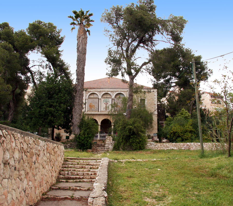
42. Ticho House

Ticho House is a historical home in Jerusalem, now a memorial house administered as part of the Israel Museum and also hosting temporary exhibitions, which also houses an Italian café. It was one of the first homes built outside the Old City walls in the 19th century.
43. Nature Museum
The Natural History Museum is a museum located in an ancient stone house near the German Colony in Jerusalem, and includes displays from the fields of natural sciences, the environment and the human body. The largest display is of stuffed birds, mammals and reptiles in the Land of Israel, past and present. One room is dedicated to the world of dinosaurs, and one section deals with the human body and its systems. The museum also hosts temporary exhibitions and activities for children.
44. Herod's Gate

Herod's Gate is one of the seven open Gates of the Old City of Jerusalem. It connects the Muslim Quarter inside of the old city to the eponymic Palestinian neighbourhood of Bab az-Zahra, situated just outside. It is a short distance to the east of the Damascus Gate. Its elevation is 755 meters above sea level.
45. Tomb of Zacharias

The Tomb of Zechariah is an ancient stone monument in Jerusalem that is considered in Jewish tradition to be the tomb of Zechariah ben Jehoiada. It is a few meters from the Tomb of Absalom and adjacent to the Tomb of Benei Hezir.
46. September 11 Monument

The 9/11 Living Memorial Plaza consists of an Israeli cenotaph surrounded by a larger complex near Ramot, Jerusalem. It was built on 5 acres (2.0 ha) of land, having been completed in 2009, and had been designed by Israeli artist Eliezer Weishoff to honour the victims of the September 11 attacks, which were carried out by al-Qaeda against the United States in 2001.
47. The Abba Cave

The Cave of Abba Hacohen is a burial cave discovered in 1970 in Jerusalem. The identity of the deceased is not known with certainty. Some scholars speculate that the deceased was Matityahu Antigonus II, the last Hasmonean king who was assassinated by the Romans in 37 years BCE. A colorful but also well-hidden inscription was discovered in the cave, carved in the rock in ancient Hebrew script identified from that period.
48. Burnt House

The Burnt House Museum is a museum presenting an excavated house from the Second Temple period. It is situated 6 m (20 ft) below current street level in the Jewish Quarter of the Old City of Jerusalem.
49. Dome of the Prophet

The Dome of the Prophet, also known as the Dome of the Messenger and the Dome of Muhammed is a free-standing dome located on the al-Masjid al-Aqsa enclave, in Quds. It is located on the northwest part of the terrace where the Dome of the Rock stands and it is near the Dome of the Ascension.
50. Tomb of the Sons of Hezir

The Tomb of Benei Hezir, previously known as the Tomb of Saint James, is the oldest of four monumental rock-cut tombs that stand in the Kidron Valley, adjacent to the Tomb of Zechariah and a few meters from the Tomb of Absalom. It dates to the period of the Second Temple. It is a complex of burial caves. The tomb was originally accessed from a single rock-cut stairwell which descends to the tomb from the north. At a later period an additional entrance was created by quarrying a tunnel from the courtyard of the monument known as "the Tomb of Zechariah". This is also the contemporary entrance to the burial complex.
51. Agnon House

The Agnon House is the house where the writer S.Y. Agnon lived, in the Talpiot neighborhood of Jerusalem, at 16 Klausner Street. The house was designed by the architect who lives in the neighborhood, Fritz Kornberg, and was built in 1931.
52. Kathisma

The Church of the Seat of Mary, Church of the Kathisma or Old Kathisma being the name mostly used in literature, was a 5th-century Byzantine church in the Holy Land, located between Jerusalem and Bethlehem, on what is today known as Hebron Road. It was built on the alleged resting place of Mary on the road to Bethlehem mentioned in the apocryphal Proto-Gospel of James. The church was built when Marian devotion first rose to great importance, following the First Council of Ephesus of 431. It is one of the earliest churches known to have been dedicated to the Theotokos in the entire Byzantine Empire.
53. גשר הרכבת

The Railway Bridge over the Cedars Valley is a bridge on the railway track of the high-speed railway line to Jerusalem. It is also known as Bridge 10 because it is the tenth and last bridge in the number of bridges in the section of the railway between Kfar Daniel and Jerusalem. The use of the bridge began in September 2018 with the inauguration of the railway line.
54. Givati Parking Lot dig

The Givati Parking Lot dig is an archaeological excavation located in Silwan in advance of building project commissioned by the El'ad Association. It is adjacent to the City of David archaeological site. The dig was conducted by Doron Ben-Ami and Yana Tchekhanovets of the Israel Antiquities Authority and underwritten by the City of David Foundation. While the IAA conducts the excavations, the project and site is managed by El'ad.
55. Ades Synagogue

The Ades Synagogue, also known as the Great Synagogue Ades of the Glorious Aleppo Community, is an Orthodox Jewish congregation and synagogue, located at 1 Beer Sheba Street, in the Nachlaot neighborhood of Jerusalem, Israel. Established in 1901 by Syrian immigrants, the synagogue is considered to be the center of Syrian Hazzanut in Israel.
56. Stepped Stone Structure

The Stepped Stone Structure is the name given to the remains at a particular archaeological site on the eastern side of the City of David, the oldest part of Jerusalem. The curved, 60-foot-high (18 m), narrow stone structure is built over a series of terraces. A casemate wall adjoins the structure from a northerly direction at the upper levels, and may have been the original city wall.
57. Ohel Yitzchak Synagogue

The Ohel Yitzchak Synagogue, also known as the Shomrei ha-Chomos Synagogue and the Ungarin Shul, is an Orthodox Jewish congregation and synagogue, located in the Muslim Quarter of the Old City of Jerusalem, Israel. It was built as a yeshiva in the 1870s by Kolel Shomrei HaChomos, an organization of Hungarian Jews, but was abandoned after the riots of 1938. Although the building was destroyed after 1948, it was reopened in October 2008 after acquisition by a Religious Zionist group and subsequent refurbishment.
58. Moscovia Monastery Lookout

The Gorny Monastery is located in Ein Kerem, where Russian Orthodox (Pervoslav) nuns live. Like many other compounds belonging to the Russian Orthodox Church in the Land of Israel, it is also known by its name from the period of Turkish rule: "Muscovy".
59. קבר אחים חללי הרובע היהודי

The Mass Grave for the Fallen of the Jewish Quarter is a mass grave on the Mount of Olives, near the Tombs of the Prophets, in Jerusalem, where 48 of the fallen soldiers of the Jewish Quarter who were killed in the War of Independence are buried.
60. חוט של חסד

Chot Shel Chesed Institutions is an organization that manages a number of Breslovian yeshivot for repentant Jews in Jerusalem, as well as projects for the dissemination of the teachings of Rabbi Nachman of Breslov, and the organization of trips to the graves of righteous people in Israel and Eastern Europe.
61. Har Hamor Yeshiva

Yeshivat Har Hamor ; is a Religious Zionist yeshiva in Har Homa, Jerusalem, founded in 1997 as an offshoot of Yeshivat Mercaz HaRav. The president of the yeshiva is Rabbi Zvi Thau, and the Rosh yeshiva - head of the yeshiva - is Rabbi Amiel Sternberg. There are around 850 students. Many of the students are married ("avrechim"), and the average student age is higher than at most Religious Zionist yeshivas.
62. Saint Saviours Church

The Monastery of Saint Saviour is a Catholic Franciscan monastery located on 1 Saint Francis Street, east of the New Gate in the Old City of Jerusalem. The site was purchased from the Georgian Orthodox Church in 1560 with permission of Sultan Suleiman the Magnificent of the Ottoman Empire, and the monastery was constructed in stages. The church building was erected in 1885, with renovation in 1985. The site includes a printing press, an organ workshop, a library and a Catholic school.
63. Ratisbonne Monastery

Ratisbonne Monastery is a monastery in the Rehavia neighborhood of Jerusalem, Israel, established by Marie-Alphonse Ratisbonne, a French convert from Judaism. Work on the building, designed by the French architect M. Daumat, began in 1874 on a barren hill, now in the center of West Jerusalem.
64. Monolith of Silwan

The Monolith of Silwan, also known as the Tomb of Pharaoh's Daughter, is a cuboid rock-cut tomb located in the Kidron Valley, in Silwan, Jerusalem dating from the period of the Kingdom of Judah. The Tomb of Pharaoh's Daughter refers to a 19th-century hypothesis that the tomb was built by Solomon for his wife, the Pharaoh's daughter. The structure, a typical Israelite rock-cut tomb, was previously capped by a pyramid structure like the Tomb of Zechariah. The upper edges of the monolith are fashioned in the shape of an Egyptian cornice. The pyramidal rock cap was cut into pieces and removed for quarry during the Roman era, leaving a flat roof. The tomb contains a single stone bench, indicating that it was designed for only one burial. Recent research indicates that the bench was the base of a sarcophagus hewn into the original building.
65. Lithostrotos
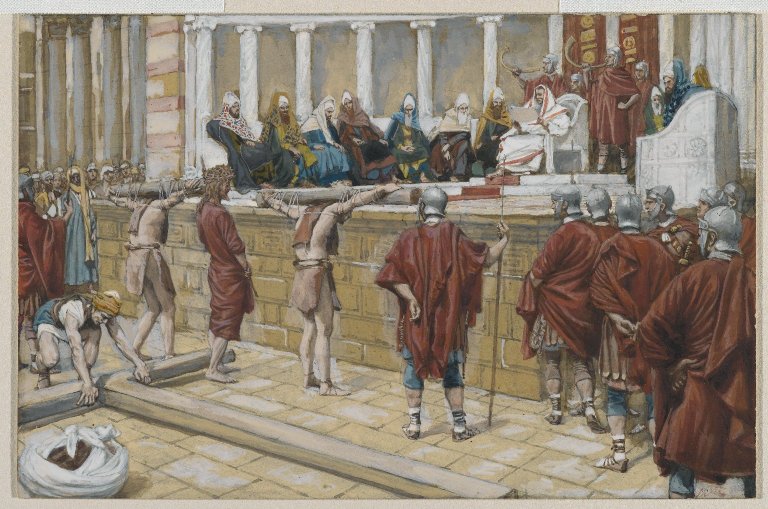
Gabbatha is the name of a place in Jerusalem that is also referred to by the Greek name of Lithostrōtos. It is recorded in the gospels to be the place of the trial of Jesus before his crucifixion c. 30/33 AD. The site of the Church of Ecce Homo is traditionally thought to be its location, but archaeological investigation has proven this unlikely. Herod's Palace is a more likely location.
66. תולדות אברהם יצחק

Toldos Avrohom Yitzchok is a Hasidic group located in Jerusalem's Mea Shearim neighborhood. It is an offshoot of the Hasidic group Toldos Aharon, which is in turn an offshoot of Shomer Emunim. It is led by its Rebbe, Rabbi Shmuel Yaakov Kohn.
67. Dome of al-Khalili

The Dome of al-Khalili or the Hebronite is a small domed-building located in the central platform of the Temple Mount, north of the Dome of the Rock in the Old City of Jerusalem. The building is made of bricks which are currently tarnished. The Dome of al-Khalili was built in the early 18th century during Ottoman rule of Palestine in dedication to Shaykh Muhammad al-Khalili, a scholar of fiqh who died in 1734.
68. Garden of the Righteous Among the Nations

The Garden of the Righteous Among the Nations is part of the much larger Yad Vashem complex located on the Mount of Remembrance in Jerusalem. Along with some two dozen different structures within the Yad Vashem memorial – which is the second most-visited destination in the country after the Western Wall – the Garden of the Righteous is meant to honor those non-Jews who during the Holocaust risked their lives to save Jews from extermination by the Nazis.
69. Jason's Tomb

Jason's Tomb is a Jewish rock-cut tomb dating to the first century BCE in the Hasmonean period, discovered in the Rehavia neighborhood in Jerusalem, Israel. It has been identified as the burial site of a certain Jason, possibly a naval commander, based on the charcoal drawing of two warships discovered in the cave.
70. Viri Galilaei Church

The Viri Galilaei Church is a Greek Orthodox church located at the northern peak of the Mount of Olives in East Jerusalem. It is part of the Monastery of Little Galilee on the Mount of Olives, which belongs to the Greek Orthodox Patriarchate of Jerusalem, and serves as the private residence of the Patriarch.
71. Chapelle Saint Vincent de Paul

The St. Vincent de Paul Chapel is a Catholic chapel that serves the Hospice of St. Vincent de Paul in Jerusalem. It is dedicated to the founder of the Daughters of Charity who also run a hospital and an adjoining nursery. This is one of the largest Catholic churches in the city. The sisters are present in the Holy Land since 1884.
72. Chapel of the Ascension

The Chapel of the Ascension is a chapel and shrine located on the Mount of Olives, in the At-Tur district of Jerusalem. Part of a larger complex, historically it started as part of a Christian church and monastery, which later became an Islamic mosque, Zawiyat al-Adawiya, and is located on a site traditionally believed to be the earthly spot where Jesus ascended into Heaven after his Resurrection. It houses a slab of stone believed to contain one of his footprints. This article deals with two sites; the Christian site of the Ascension, and the adjacent but separate mosque built over an ancient grave.
73. Ecce Homo Basilica

The Convent of the Sisters of Zion is a Roman Catholic convent of the Congregation of Notre-Dame de Sion, located near the eastern end of the Via Dolorosa in the Old City of Jerusalem. The convent was built in 1857 by Marie-Alphonse Ratisbonne. The site includes the Church of Ecce Homo, also known as the Basilica of Ecce Homo, named for Pontius Pilate's Ecce homo speech which is traditionally thought to have taken place on the pavement below the church.
74. Great Synagogue

The Jerusalem Great Synagogue is an Orthodox Jewish congregation and synagogue, located at 56 King George Street, Jerusalem, Israel. Different parts of the congregation worship in the Ashkenazi and Sephardic rites.
75. St. Peter of Gallicantu

Church of Saint Peter in Gallicantu is a Roman Catholic church located on the eastern slope of Mount Zion, just outside the walled Old City of Jerusalem. It is dedicated to the episode from the New Testament known as the Denial of Peter.
76. Magharat Umm el 'Amid

um el-Amad Cave or Cave of the Courses is a Jewish burial cave from the Second Temple period. The cave is located in the Nahal Tzofim Park in Jerusalem, which extends under the neighborhoods of Ramot Eshkol and Givat Hamivtar.
Share
How likely are you to recommend us?
Disclaimer Please be aware of your surroundings and do not enter private property. We are not liable for any damages that occur during the tours.