Self-guided Sightseeing Tour #1 in Jerusalem, Israel
Legend
Guided Free Walking Tours
Book free guided walking tours in Jerusalem.
Guided Sightseeing Tours
Book guided sightseeing tours and activities in Jerusalem.
Tour Facts
1.7 km
68 m
Experience Jerusalem in Israel in a whole new way with our free self-guided sightseeing tour. This site not only offers you practical information and insider tips, but also a rich variety of activities and sights you shouldn't miss. Whether you love art and culture, want to explore historical sites or simply want to experience the vibrant atmosphere of a lively city - you'll find everything you need for your personal adventure here.
Activities in JerusalemIndividual Sights in JerusalemSight 1: Golden Gate

The Golden Gate or Gate of Mercy is the only eastern gate of the Temple Mount, and one of only two Gates of the Old City of Jerusalem that used to offer access into the city from the East side.
Sight 2: Saint Anne Church

The Church of Saint Anne is a French Roman Catholic church and part of the French national domain in the Holy Land located in the Muslim Quarter of the Old City of Jerusalem, near the start of the Via Dolorosa, next to the Lions' Gate. The site is also known as al-Madrasa as-Salahiyya.
Sight 3: Pool of Bethesda
Get Ticket*
The Pool of Bethesda is referred to in John's Gospel in the Christian New Testament, in an account of Jesus healing a paralyzed man at a pool of water in Jerusalem, described as being near the Sheep Gate and surrounded by five covered colonnades or porticoes. It is also referred to as Bethzatha. It is now associated with the site of a pool in the current Muslim Quarter of the city, near the gate now called the Lions' Gate or St. Stephen's Gate and the Church of St. Anne, which was excavated in the late 19th century.
Sight 4: Lions' Gate
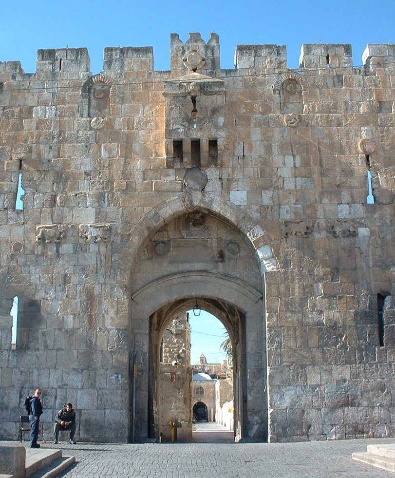
Lions' Gate, also St Stephen's Gate, is one of the seven open Gates of the Old City of Jerusalem. It leads into the Muslim Quarter of the Old City.
Sight 5: Throne of Solomon

The Throne of Solomon is the throne of King Solomon in the Hebrew Bible, and is a motif in Judaism, Christianity and Islam.
Sight 6: Tomb of the Virgin Mary

Church of the Sepulchre of Saint Mary, also Tomb of the Virgin Mary (Hebrew: קבר מרים; or the Church of the Assumption, is a Christian church built around an ancient Judean rock-cut tomb in the Kidron Valley – at the foot of Mount of Olives, in East Jerusalem – believed by Eastern Christians to be the burial place of Mary, the mother of Jesus. The Status Quo, a 250-year old understanding between religious communities, applies to the site.
Sight 7: Church of All Nations
Get Ticket*
The Church of All Nations, also known as the Church of Gethsemane or the Basilica of the Agony, is a Catholic church located on the Mount of Olives in East Jerusalem, next to the Garden of Gethsemane. It enshrines a section of bedrock where Jesus is said to have prayed before his arrest.
Sight 8: Garden of Gethsemane
Get Ticket*
Gethsemane is a garden at the foot of the Mount of Olives in East Jerusalem, where, according to the four Gospels of the New Testament, Jesus Christ underwent the Agony in the Garden and was arrested before his crucifixion. It is a place of great resonance in Christianity. There are several small olive groves in church property, all adjacent to each other and identified with biblical Gethsemane.
Sight 9: Church of Mary Magdalene

The Church of Mary Magdalene is an Eastern Orthodox Christian church located on the Mount of Olives, directly across the Kidron Valley and near the Garden of Gethsemane in Jerusalem.
Share
How likely are you to recommend us?
Disclaimer Please be aware of your surroundings and do not enter private property. We are not liable for any damages that occur during the tours.
GPX-Download For navigation apps and GPS devices you can download the tour as a GPX file.