Self-guided Sightseeing Tour #4 in Nuremberg, Germany
Legend
Guided Free Walking Tours
Book free guided walking tours in Nuremberg.
Guided Sightseeing Tours
Book guided sightseeing tours and activities in Nuremberg.
Tour Facts
3.5 km
48 m
Experience Nuremberg in Germany in a whole new way with our free self-guided sightseeing tour. This site not only offers you practical information and insider tips, but also a rich variety of activities and sights you shouldn't miss. Whether you love art and culture, want to explore historical sites or simply want to experience the vibrant atmosphere of a lively city - you'll find everything you need for your personal adventure here.
Activities in NurembergIndividual Sights in NurembergSight 1: Cramer-Klett-Park

Cramer-Klett-Park is a small park in Nuremberg, Germany.
Sight 2: Erfahrungsfeld zur Entfaltung der Sinne

The Erfahrungsfeld zur Entfaltung der Sinne is an interactive exhibition that stimulates all the senses, designed by Hugo Kükelhaus. The different exhibits are intended to inspire the visitor to experiment with them, to explore them, like in a park of the senses or a science center. Kükelhaus constructed 32 pieces of playground equipment for schools in the city of Dortmund and demonstrated some of these equipment at the Expo 67 world exhibition in Montreal. His holistic concept for a large open-air exhibition was shown in the exhibition Phenomena, shown in Rotterdam, South Africa, and Bietigheim, among others.
Wikipedia: Erfahrungsfeld zur Entfaltung der Sinne (EN), Website
Sight 3: Kunstvilla

The Kunstvilla Nürnberg is a municipal museum in Nuremberg that deals with the presentation, mediation and research of regional art. It is located in a listed neo-baroque merchant's villa in Marienvorstadt and is part of the KunstKulturQuartier.
Sight 4: Kunsthalle Nürnberg
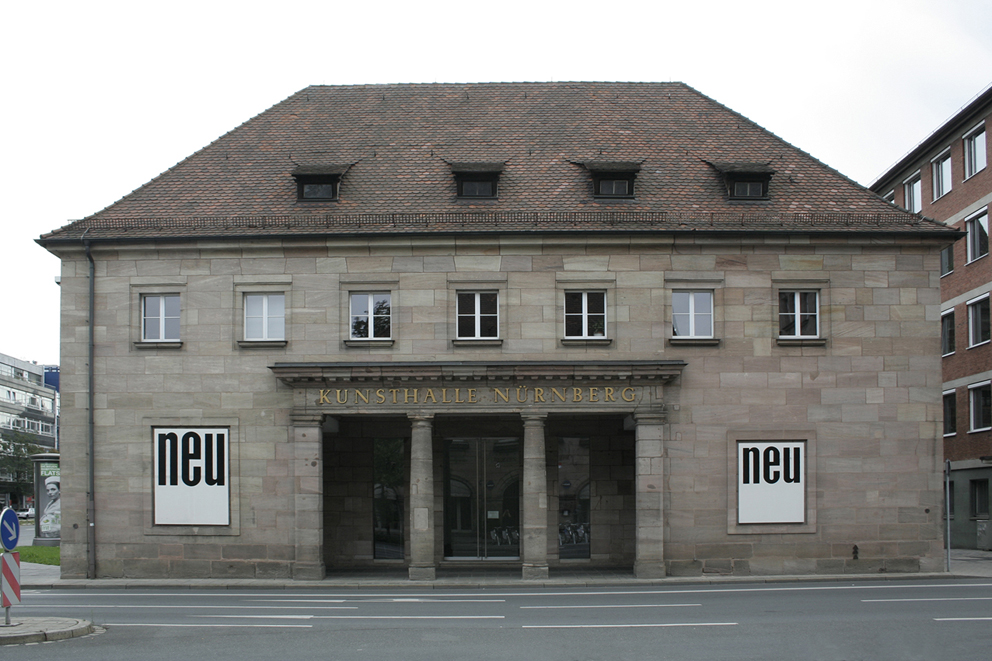
The Kunsthalle Nürnberg is an art centre founded in 1967, near the city centre. It organizes exhibitions by contemporary international artists in its galleries in Nuremberg. The Kunsthalle commissions new work by a majority of the artists it works with.
Sight 5: Frauentorturm

The Frauentor was the main gate in the southeast of the Nuremberg city wall.
Sight 6: Craftmen's Courtyard

The Handwerkerhof Nürnberg was created in 1971 as a tourist attraction in the so-called "Waffenhof" of the Frauentor, the last Nuremberg city fortification. It is located at the entrance to the old town "Königstor" and thus on the footpath from Nuremberg Central Station to Nuremberg's traditional tourist destinations.
Sight 7: Neues Museum

Neues Museum Nürnberg (NMN) is a museum for modern and contemporary art and design in Nuremberg.
Sight 8: St. Martha

St. Martha is a medieval church in the old town of Nuremberg in southern Germany. It is dedicated to Saint Martha. Since 1800 it is a Reformed church, the community of which forms part of the Evangelical Reformed Church.
Sight 9: St. Klara

St. Klara is a Roman Catholic church in the old town of Nuremberg, Germany. The building is located in the Altstadt, St. Lorenz district on Königstraße between Lorenzkirche and Frauentor. The construction, which began in 1270, is one of the oldest surviving sacred buildings in the city and initially served as a place of worship for the Poor Clares monastery. In the course of the Reformation, the monastery was dissolved and the church was used as a Protestant preaching church from 1574. After Nuremberg fell to Bavaria in 1806, the building was profaned. Since 1854 it has been a Catholic church again. During the Second World War, the church was severely damaged in a bombing raid, and in the post-war period it was rebuilt in its previous form. In 1979, the church rectorate was transferred to the Jesuits. Since 1996, St. Klara has been an open church with a wide range of spiritual and cultural offerings.
Sight 10: Heunensäule

The Heunen columns, also known as the Heune columns, are round columns made of sandstone, which were originally intended for the reconstruction of the Willigis Cathedral in Mainz, which burned down in 1009. They were probably completed in the 11th century out of anticipatory business acumen in a quarry in the Bullau Mountains near Miltenberg even before the order was placed. However, the client probably opted for other supports, so that the round columns were never needed. There are said to have been 42 of the columns at one time, in the 18th century there were still 14, around 1960 only eight are known.
Sight 11: Way of Human Rights

The Way of Human Rights is a monumental outdoor sculpture in Nuremberg, Germany. It was opened on 24 October 1993. It is sited on the street between the new and old buildings of the Germanisches Nationalmuseum, connecting Kornmarkt street and the medieval city wall.
Sight 12: Former Customs House

The Mauthalle is a medieval imperial city building in Nuremberg, Germany. It is one of the most important architectural monuments in Nuremberg's old town and is a stop on the Nuremberg Historic Mile.
Sight 13: St. Lawrence Church
Get Ticket*
St. Lorenz is a medieval church of the former free imperial city of Nuremberg in southern Germany. It is dedicated to Saint Lawrence by the Roman Catholic Church. The church was badly damaged during the Second World War and later restored. It is one of the most prominent churches of the Evangelical Lutheran Church in Bavaria.
Share
How likely are you to recommend us?
Disclaimer Please be aware of your surroundings and do not enter private property. We are not liable for any damages that occur during the tours.
GPX-Download For navigation apps and GPS devices you can download the tour as a GPX file.