Self-guided Sightseeing Tour #2 in Nuremberg, Germany
Legend
Guided Free Walking Tours
Book free guided walking tours in Nuremberg.
Guided Sightseeing Tours
Book guided sightseeing tours and activities in Nuremberg.
Tour Facts
10.1 km
157 m
Experience Nuremberg in Germany in a whole new way with our free self-guided sightseeing tour. This site not only offers you practical information and insider tips, but also a rich variety of activities and sights you shouldn't miss. Whether you love art and culture, want to explore historical sites or simply want to experience the vibrant atmosphere of a lively city - you'll find everything you need for your personal adventure here.
Activities in NurembergIndividual Sights in NurembergSight 1: Peter-Henlein-Brunnen

Der Peter-Henlein-Brunnen am Hefnersplatz in Nürnberg wurde zu Ehren des mutmaßlichen Erfinders der Taschenuhr Peter Henlein errichtet. Der von der Stadt Nürnberg und dem Uhrmacherbund gestiftete Brunnen wurde zur Eröffnung einer Uhrenausstellung 1905 enthüllt. Das Bronze-Standbild wurde nach einem Modell des Berliner Bildhauers Max Meißner durch die Nürnberger Kunstgießerei Ernst Lenz ausgeführt.
Sight 2: Ehekarussell
Get Ticket*
The marriage carousel, actually Hans Sachs Fountain, is a large-scale architectural fountain in Nuremberg. It is located directly in front of the White Tower in the pedestrian zone in Nuremberg's city center.
Sight 3: Weißer Turm

The White Tower is a gate tower of the penultimate city fortifications of Nuremberg.
Sight 4: St. Jakob

St. Jakob is a medieval church of the former free imperial city of Nuremberg in southern Germany. It is dedicated to Saint James the Greater. The church was badly damaged during the Second World War and later restored.
Sight 5: Feuerwehrmuseum

The Nuremberg Fire Brigade Museum shows the history of German fire extinguishing in Nuremberg.
Sight 6: St. Elisabeth
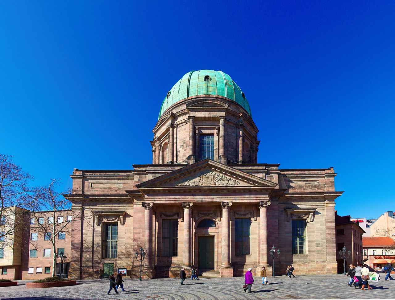
St. Elizabeth's is a Roman Catholic church in Nuremberg in southern Germany. It is dedicated to Elizabeth of Hungary.
Sight 7: Rosenau

The Rosenaupark or the Rosenau is a park of about 3 hectares in Nuremberg. It lies in the Kleinweidenmühle district west of the Fürth Gate in front of the walls of the old town in a depression that geologically appears as a dry oxbow of the nearby Pegnitz.
Sight 8: St. Rochusfriedhof

St. Rochus Cemetery (Rochusfriedhof) is a cemetery in Nuremberg, Germany. It is located in the Gostenhof quarter.
Sight 9: Nicolaus-Copernicus-Planetarium Nürnberg

The Nicolaus Copernicus Planetarium in Nuremberg at the inner-city transport hub Plärrer is the only large planetarium in Bavaria. Together with the Nuremberg Education Centre (adult education centre) and the Nuremberg City Library, it forms the Nuremberg Education Campus. In 2017, 78,000 visitors were recorded.
Sight 10: Transit
Get Ticket*
The Forced Laborer Memorial "Transit" is a Nuremberg monument. It is located at the Plärrer, a main traffic junction of the Nuremberg city centre, just outside the city wall. The aim is to keep the memory of the fate of the Nuremberg forced laborers during the Nazi era alive.
Sight 11: Spittlertorturm

The Spittlertor is an old gate in the southwest of the Nuremberg city wall. The name refers to the nearby St. Elisabeth Hospital of the Teutonic Order.
Sight 12: Salz+Pfeffer

The Salz+Pfeffer Theatre is a private theatre in Nuremberg, Germany. It was opened in 1997 and is run by Paul Schmidt and Wally Schmidt as a partnership under civil law.
Sight 13: DB Museum
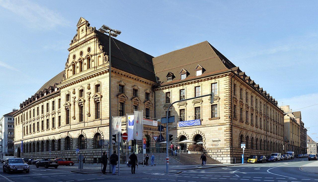
The Nuremberg Transport Museum in Nuremberg, Germany, consists of Deutsche Bahn's DB Museum and the Museum of Communications. It also has two satellite museums at Koblenz-Lützel and Halle. The Nuremberg Transport Museum is one of the oldest technical history museums in Europe and is a milestone on the European Route of Industrial Heritage (ERIH).
Sight 14: Gedenkstätte für die Opfer des nationalsozialistischen Untergrunds

The NSU murder series refers to nine racially motivated murders of entrepreneurs with a migrant background, eight of them of Turkish origin and one Greek, which were committed by the right-wing extremist terrorist group National Socialist Underground (NSU) in major German cities between 2000 and 2006. The official investigations focused on the victims themselves and their relatives, which led to their victimization and stigmatization, while hardly any investigations were conducted in the direction of a right-wing extremist motivation. In the leading media, the acts were misleadingly called kebab murders or – after the title of the homicide squad involved – the Bosporus series of murders, which was criticized from 2011 onwards as trivializing, clichéd and racist. The eponymous murder weapon, a Česká CZ 83 pistol, caliber 7.65 mm Browning, was seized in November 2011 in the rubble of the last NSU apartment in Zwickau.
Sight 15: 18. Artikel der Menschenrechte

The Way of Human Rights is a monumental outdoor sculpture in Nuremberg, Germany. It was opened on 24 October 1993. It is sited on the street between the new and old buildings of the Germanisches Nationalmuseum, connecting Kornmarkt street and the medieval city wall.
Sight 16: Heunensäule

The Heunen columns, also known as the Heune columns, are round columns made of sandstone, which were originally intended for the reconstruction of the Willigis Cathedral in Mainz, which burned down in 1009. They were probably completed in the 11th century out of anticipatory business acumen in a quarry in the Bullau Mountains near Miltenberg even before the order was placed. However, the client probably opted for other supports, so that the round columns were never needed. There are said to have been 42 of the columns at one time, in the 18th century there were still 14, around 1960 only eight are known.
Sight 17: Neues Museum

Neues Museum Nürnberg (NMN) is a museum for modern and contemporary art and design in Nuremberg.
Sight 18: Craftmen's Courtyard

The Handwerkerhof Nürnberg was created in 1971 as a tourist attraction in the so-called "Waffenhof" of the Frauentor, the last Nuremberg city fortification. It is located at the entrance to the old town "Königstor" and thus on the footpath from Nuremberg Central Station to Nuremberg's traditional tourist destinations.
Sight 19: Frauentorturm

The Frauentor was the main gate in the southeast of the Nuremberg city wall.
Sight 20: St. Martha

St. Martha is a medieval church in the old town of Nuremberg in southern Germany. It is dedicated to Saint Martha. Since 1800 it is a Reformed church, the community of which forms part of the Evangelical Reformed Church.
Sight 21: St. Klara

St. Klara is a Roman Catholic church in the old town of Nuremberg, Germany. The building is located in the Altstadt, St. Lorenz district on Königstraße between Lorenzkirche and Frauentor. The construction, which began in 1270, is one of the oldest surviving sacred buildings in the city and initially served as a place of worship for the Poor Clares monastery. In the course of the Reformation, the monastery was dissolved and the church was used as a Protestant preaching church from 1574. After Nuremberg fell to Bavaria in 1806, the building was profaned. Since 1854 it has been a Catholic church again. During the Second World War, the church was severely damaged in a bombing raid, and in the post-war period it was rebuilt in its previous form. In 1979, the church rectorate was transferred to the Jesuits. Since 1996, St. Klara has been an open church with a wide range of spiritual and cultural offerings.
Sight 22: Former Customs House

The Mauthalle is a medieval imperial city building in Nuremberg, Germany. It is one of the most important architectural monuments in Nuremberg's old town and is a stop on the Nuremberg Historic Mile.
Sight 23: Nassauer Haus

The Nassauer Haus or Schlüsselfeldersche Stiftungshaus in Nuremberg is a medieval residential tower made of so-called red castle sandstone. Although originally built in Romanesque style, the house is still characterized by Gothic style elements after some renovations. It is the last surviving residential tower in Nuremberg.
Sight 24: St. Lawrence Church
Get Ticket*
St. Lorenz is a medieval church of the former free imperial city of Nuremberg in southern Germany. It is dedicated to Saint Lawrence by the Roman Catholic Church. The church was badly damaged during the Second World War and later restored. It is one of the most prominent churches of the Evangelical Lutheran Church in Bavaria.
Sight 25: Fleischbrücke
Get Ticket*
The Fleisch Bridge or Pegnitz Bridge (Pegnitzbrücke) is a late Renaissance bridge in Nuremberg, Germany. The bridge crosses the river Pegnitz in the center of the old town, linking the districts St. Sebald and St. Lorenz along the axis of the main market. The single-arch bridge was built between 1596 and 1598 and replaced an earlier mixed construction of stone and wood which had been repeatedly destroyed by flood.
Sight 26: Beautiful Fountain
Get Ticket*
Schöner Brunnen is a 14th-century fountain located on Nuremberg's main market next to the town hall and is considered one of the main attractions of the city's Historical Mile. The fountain is approximately 19 metres high and has the shape of a Gothic spire.
Sight 27: Frauenkirche
Get Ticket*
The Frauenkirche is a church in Nuremberg, Germany. It stands on the eastern side of the main market. An example of brick Gothic architecture, it was built on the initiative of Charles IV, Holy Roman Emperor between 1352 and 1362. The church contains many sculptures, some of them heavily restored. Numerous works of art from the Middle Ages are kept in the church, such as the so-called Tucher Altar, and two monuments by Adam Kraft. It has been a parish church of the Catholic Church since 1810.
Sight 28: Ship of fools

The Ship of Fools Fountain is a dry-placed fountain sculpture in Nuremberg. It is the work of the sculptor Jürgen Weber, who died in 2007.
Sight 29: Museumsbrücke

The Museum Bridge is a sandstone arch bridge that spans the Pegnitz River in Nuremberg. The road bridge is located at the beginning of Königstraße and connects the Nuremberg districts of St. Sebald and St. Lorenz. It is located between the main market square and Lorenzer Platz.
Sight 30: Synagogendenkmal

The synagogue monument in Nuremberg commemorates the main synagogue on Hans-Sachs-Platz, which was demolished on August 10, 1938, i.e. before the November pogroms, at the behest of Julius Streicher. The monument on the Spital Bridge at the junction of Leo-Katzenberger-Weg consists mainly of a relief of the no longer existing synagogue by Reinhard Heiber (1988) and a memorial stele by August Hofmann (1970) erected in front of it.
Sight 31: Heilig-Geist-Spital

The Heilig-Geist-Spital in Nuremberg was the largest hospital in the former Free Imperial City of Nuremberg. It was used as a hospital and nursing home.
Sight 32: St. Katharina
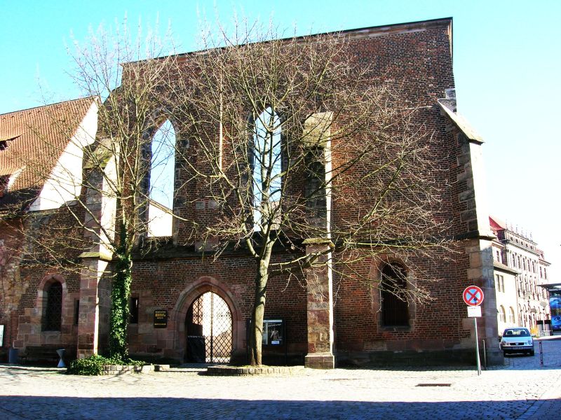
St. Katharina in Nuremberg, Bavaria, was an important medieval church, destroyed during the Second World War and preserved as a ruin.
Sight 33: Uhrenmuseum

The Karl Gebhardt Clock Collection in Nuremberg is a collection of mechanical clocks.
Sight 34: Grande Disco

Grande Disco is a bronze sculpture by Arnaldo Pomodoro from 1972 that is located in Milan.
Sight 35: Stadtarchiv Nürnberg

The Nuremberg City Archive is the central archive for the interests of Nuremberg's city history. As a municipal authority, it is a service provider for the public, research and the city administration. Since 2000, the city archive has been located in the Norishalle at Marientorgraben 8. The holdings of the city archive date back to the 11th century and comprise almost 20 kilometres of shelves.
Sight 36: Naturhistorisches Museum

The Natural History Society of Nuremberg (NHG), founded in 1801, is currently one of the largest voluntary scientific associations in Germany with about 1500 members.
Sight 37: Kunsthalle Nürnberg
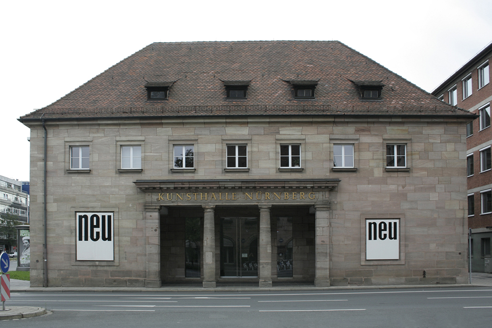
The Kunsthalle Nürnberg is an art centre founded in 1967, near the city centre. It organizes exhibitions by contemporary international artists in its galleries in Nuremberg. The Kunsthalle commissions new work by a majority of the artists it works with.
Sight 38: Kunstvilla

The Kunstvilla Nürnberg is a municipal museum in Nuremberg that deals with the presentation, mediation and research of regional art. It is located in a listed neo-baroque merchant's villa in Marienvorstadt and is part of the KunstKulturQuartier.
Sight 39: Erfahrungsfeld zur Entfaltung der Sinne

The Erfahrungsfeld zur Entfaltung der Sinne is an interactive exhibition that stimulates all the senses, designed by Hugo Kükelhaus. The different exhibits are intended to inspire the visitor to experiment with them, to explore them, like in a park of the senses or a science center. Kükelhaus constructed 32 pieces of playground equipment for schools in the city of Dortmund and demonstrated some of these equipment at the Expo 67 world exhibition in Montreal. His holistic concept for a large open-air exhibition was shown in the exhibition Phenomena, shown in Rotterdam, South Africa, and Bietigheim, among others.
Wikipedia: Erfahrungsfeld zur Entfaltung der Sinne (EN), Website
Sight 40: Cramer-Klett-Park

Cramer-Klett-Park is a small park in Nuremberg, Germany.
Sight 41: Der blaue Reiter

The cultural and art-historical significance of Nuremberg was rediscovered by Ludwig Tieck and Wilhelm Heinrich Wackenroder at the end of the 18th century. The old town, which was largely destroyed in the Second World War, was partially restored to its historical form in the decades after 1945. The list of monuments in Nuremberg lists all monuments in the city individually.
Share
How likely are you to recommend us?
Disclaimer Please be aware of your surroundings and do not enter private property. We are not liable for any damages that occur during the tours.
GPX-Download For navigation apps and GPS devices you can download the tour as a GPX file.