Free Walking Sightseeing Tour #13 in Hamburg, Germany

Legend

Churches & Art
Nature
Water & Wind
Historical
Heritage & Space
Tourism
Paid Tours & Activities

Tour Facts

Number of sights 18 sights
Distance 10.2 km
Ascend 105 m
Descend 125 m

Explore Hamburg in Germany with this free self-guided walking tour. The map shows the route of the tour. Below is a list of attractions, including their details.

Activities in HamburgIndividual Sights in Hamburg

Sight 1: Altonaer Bahnwasserturm

Show sight on map

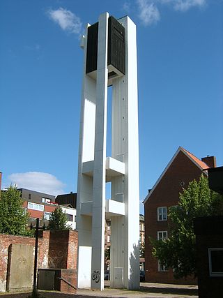
The water tower of the former Hamburg-Altona depot is located at the junction of the connecting line to the Hamburg-Altona terminus. It was built in 1954/55 and is one of the youngest water towers in Hamburg.

Wikipedia: Wasserturm (Bahnbetriebswerk Hamburg-Altona) (DE)

1491 meters / 18 minutes

Sight 2: Wohlers Park

Show sight on map

The cemetery Norderreihe or Wohlers Park because of its location on Wohlers Allee, is a former cemetery in Altona-Altstadt. It was inaugurated in 1831 and the last funeral took place in 1945. It has been a listed building since 1979 and has also been designated as a public park of about 4.6 hectares.

Wikipedia: Friedhof Norderreihe (DE)

190 meters / 2 minutes

Sight 3: Sankt Johannis Altona

Show sight on map

The Evangelical Lutheran Church of St. Johannis in Hamburg-Altona is a neo-Gothic church building from 1873. It belongs to the parish of Altona-Ost in the church district of Hamburg-West/Südholstein of the Evangelical Lutheran Church in Northern Germany. Since 1998, it has also been home to the Kulturkirche Altona, a non-profit cultural organiser and landlord of the church space on behalf of the Altona-Ost parish.

Wikipedia: St. Johannis (Altona) (DE)

95 meters / 1 minutes

Sight 4: Gefallenendenkmal des Infanterie-Regiments 31

Show sight on map

902 meters / 11 minutes

Sight 5: DELPHI Showpalast

Show sight on map

The Delphi Showpalast is a show and gastronomy theatre in the Eimsbüttel district of Hamburg.

Wikipedia: Delphi Showpalast (DE), Website, Url

961 meters / 12 minutes

Sight 6: Mövenpick

Show sight on map

The Sternschanzenpark, usually called Schanzenpark, is an approximately twelve-hectare, semi-public park with the 60-metre-high Schanzenturm, formerly the largest water tower in Europe, in which a hotel has been located since 2007, on a 28-metre-high hill in the district of Hamburg-Altona.

Wikipedia: Sternschanzenpark (DE), Website

891 meters / 11 minutes

Sight 7: Gedenk- und Bildungsstätte Israelitische Töchterschule

Show sight on map

The Israelite Girls' School was a school in Hamburg's Karolinenviertel that existed from 1884 to 1942.

Wikipedia: Israelitische Töchterschule (DE)

348 meters / 4 minutes

Sight 8: Heinrich-Hertz-Turm

Show sight on map
Heinrich-Hertz-Turm Credit: Detail of photo taken by Kristof Hamann on 2004-06-21. / CC BY-SA 3.0

The Heinrich Hertz Tower is a landmark radio telecommunication tower in the city of Hamburg, Germany.

Wikipedia: Heinrich Hertz Tower (EN)

1179 meters / 14 minutes

Sight 9: Synagogenmonument

Show sight on map
Synagogenmonument

The synagogue on Bornplatz in Hamburg's Grindel district was inaugurated in 1906 and was one of the largest synagogues in Germany. It served as the main synagogue of the German Israelite Community (DIG). In the immediate vicinity, the building of the Talmud Torah School was erected in 1911.

Wikipedia: Bornplatzsynagoge (DE)

279 meters / 3 minutes

Sight 10: [Weiße Rose Hamburg]

Show sight on map

White Rose Hamburg was a resistance group working against National Socialism in Hamburg. Those involved did not call themselves that, and for the most part did not see themselves as resistance fighters. The term, used by researchers after 1945, encompasses several circles of friends and family, some of whom had been in opposition to National Socialism since 1936 and who, following the actions of the White Rose in Munich and their continuation, acted against the Nazi regime and the Second World War from 1942. Although many members belonged to an older generation, the group is classified as a youth and student opposition. There were isolated personal contacts with other resistance groups in Hamburg, but cooperation did not materialize.

Wikipedia: White Rose Hamburg (EN)

457 meters / 5 minutes

Sight 11: Curio-Haus

Show sight on map

The Curiohaus is an office and event building in Hamburg, Germany, in the district of Eimsbüttel, in the Rotherbaum district. It was built between 1908 and 1911 according to a design by the architects Johann Emil Schaudt and Walther Puritz at Rothenbaumchaussee 11–17 for the Society of Friends of the Patriotic School and Education System and named after the founder of this society, Johann Carl Daniel Curio. Since 1948, it has been the property and headquarters of the Hamburg branch of the Education and Science Union (GEW). In October 1997, the building as a whole and with its permanent furnishings, the front garden pedestals, the lamps and the oval of the courtyard garden was placed under monument protection.

Wikipedia: Curiohaus (DE), Website

484 meters / 6 minutes

Sight 12: Moorweide

Show sight on map

The moor pasture is a public green area in the Rotherbaum district of Hamburg, north of the Dammtor station. It was originally limited by Edmund-Siemers-Allee, Moorweidenstraße, the Mittelweg, the Neue Rabenstraße and Alsterglacis. The part west of the Rothenbaumchaussee has been built on with the main building of the university since 1919 and is no longer officially counted on moor willow in the narrower sense. The remaining main part between Rothenbaumchaussee and Mittelweg is also known as a large moor pasture, the strip between Mittelweg and Neuer Rabenstraße as a small moor pasture. Overall, today's park is approximately 4.3 hectares and entered the Hamburg list of monuments as a "important garden monument".

Wikipedia: Moorweide (DE)

577 meters / 7 minutes

Sight 13: Fontenay-Denkmal

Show sight on map

The Fontenay Monument is a monument in Hamburg-Rotherbaum, Germany. It commemorates John Fontenay, a merchant, shipowner and shipbroker who lived and worked in Hamburg between 1801 and 1835. The building has been a listed building since October 1962.

Wikipedia: Fontenay-Denkmal (DE)

45 meters / 1 minutes

Sight 14: Regiments-Kriegerdenkmal 1870/71 des Infanterie-Regiments

Show sight on map

The War Memorial 1870/71 is a monument in Hamburg-Rotherbaum, Germany.

Wikipedia: Kriegerdenkmal 1870/71 (Hamburg-Rotherbaum) (DE)

663 meters / 8 minutes

Sight 15: Villa Laeisz

Show sight on map

The Harvestehuder Weg is a road in the Hamburg district of Eimsbüttel, which runs along the foreland of the Outer Alster from the Alte Rabenstraße to the Klosterstern for a length of two kilometers through the districts of Rotherbaum and Harvestehude. With numerous detached villas from the late 19th and early 20th centuries, in the midst of large, partly park-like gardens, it is considered a boulevard of the Hanseatic city and, along with the Elbchaussee, a testimony to the wealth of Hamburg's merchants and entrepreneurs during the Wilhelminian period.

Wikipedia: Harvestehuder Weg (DE)

320 meters / 4 minutes

Sight 16: Budge-Palais

Show sight on map

The Budge Palace is a classicist villa building by the architect Martin Haller am Harvestehuder Weg 12, corner of Milky Way, in the Hamburg district of Rotherbaum in the Eimsbüttel district. It was built as a residential building in 1884 and later converted several times. From 1903 it lived in Henry (1840–1928) and Emma Budge (1852–1937). After a dubious purchase by the city of Hamburg, it was the seat of the Reichsstobsthalteri under the Gauleiter Karl Kaufmann from 1938 to 1945. The building has been used by the Hamburg University of Music and Theater (HfMT) since 1959 and has been expanded with growing modern architecture. In April 2011, an agreement with the budget heirs was reached after a restitution request, the palace remains owned by the city.

Wikipedia: Budge-Palais (DE)

467 meters / 6 minutes

Sight 17: St. Johannis Harvestehude

Show sight on map

St. Johannis-Harvestehude is an Evangelical Lutheran church in Hamburg, Germany. It was built between 1880 and 1882 by Wilhelm Hauers in the neo-Gothic style. It has been largely preserved and restored in its original architecture and artistic furnishings. Due to today's district boundaries, the church is located in the district of Rotherbaum, not Harvestehude.

Wikipedia: St. Johannis (Harvestehude) (DE), Website

859 meters / 10 minutes

Sight 18: Alstervorland

Show sight on map

The Alsterpark runs along the banks of the Alster around the Outer Alster and includes the areas of Schwanenwik, the Eduard-Rhein-Ufer and the Alster foreland. Starting in the south, the park leads east through the Hamburg districts of St. Georg, Hohenfelde, Uhlenhorst and Winterhude, from the Krugkoppelbrücke west through the Alster foreland in Harvestehude and Rotherbaum to the Kennedy Bridge at the junction with the Inner Alster.

Wikipedia: Alsterpark (DE)

Share

Spread the word! Share this page with your friends and family.

Disclaimer Please be aware of your surroundings and do not enter private property. We are not liable for any damages that occur during the tours.

GPX-Download For navigation apps and GPS devices you can download the tour as a GPX file.