Self-guided Sightseeing Tour #1 in Erfurt, Germany
Legend
Tour Facts
8.1 km
119 m
Experience Erfurt in Germany in a whole new way with our free self-guided sightseeing tour. This site not only offers you practical information and insider tips, but also a rich variety of activities and sights you shouldn't miss. Whether you love art and culture, want to explore historical sites or simply want to experience the vibrant atmosphere of a lively city - you'll find everything you need for your personal adventure here.
Individual Sights in ErfurtSight 1: Sibyllentürmchen

The Sibyllentürmchen is a devotional column on Gothaer Platz below the Cyriaksburg in the west of Erfurt (Brühlervorstadt). It was built between 1370 and 1380 in the Gothic style.
Sight 2: Christuskirche (SELK)

The Evangelical Lutheran Church of Christ is a church in the Brühlervorstadt district of Erfurt. It serves as a place of worship for the Erfurt congregation of the Independent Evangelical Lutheran Church (SELK) and belongs to the church district of Saxony-Thuringia.
Sight 3: Sankt Martini

St Martin's Church in the west of the historical centre of the city of Erfurt in Thuringia, Germany, is a Roman Catholic church building. Today, it is a subsidiary church of the Catholic parish of St Lawrence's.
Sight 4: Theater Erfurt

The Theater Erfurt is a German municipal theatre located in Erfurt, the capital of Thuringia. The main stage is in a building in the Brühlervorstadt, completed in 2003. The theatre offers musical theatre and concerts, played by the Philharmonisches Orchester Erfurt. Ballet and plays are offered by guest performances. The company organizes the annual open air festival DomStufen. The theatre's current Generalintendant, Guy Montavon, has held the post since 2002.
Sight 5: Brühler Garten

The Brühler Garten is a small park in the old town of Erfurt. It is located in Brühl in the southwestern city center.
Sight 6: Roßbrücke

The Roßbrücke is a road bridge in the city centre of Erfurt, the capital of Thuringia, and is one of the oldest preserved natural stone bridges in the city. It is located on Herrmannsplatz, spans the Walkstrom, a tributary of the Gera, and serves the development traffic of the western city centre.
Sight 7: Brunnenkirche

The Roman Catholic fountain church is located in the old town of the Thuringian state capital Erfurt. It is used by the Erfurt Augustinian Convent and belongs to the Erfurt Deanery of the Diocese of Erfurt.
Sight 8: Sankt Crucis

The Neuwerkskirche at the edge of the historical part of the city of Erfurt in Thuringia, Germany, is a Roman Catholic church building dating from the 15th century. Today, it is a branch church of the Catholic parish of St Lawrence's Church.
Sight 9: Hirschgarten

The Hirschgarten is a partly park-like green space in the old town of Erfurt. It was the first public green space in the city. Today it consists of the historic Hirschgarten from the 18th century and an adjoining part to the west, which was redesigned on a demolition site in the years 2007 to 2009.
Sight 10: Westliches Wachhaus

The Electoral Mainz Lieutenancy is a baroque, three-storey four-winged complex around an inner courtyard from the 16th to 18th centuries. It is located on the corner of Regierungsstrasse and Meister-Eckehart-Strasse in the centre of Erfurt.
Sight 11: Haus Vaterland

Haus Vaterland in Erfurt, the state capital of Thuringia, is located at Regierungsstraße 72. Haus Vaterland, the former Weimar escort house in Erfurt, houses the European Information Centre and offices of the Thuringian State Chancellery. The building is a protected architectural monument.
Sight 12: Sankt Wigbert

St Wigbert's Church in the city of Erfurt in Thuringia, Germany, is a Roman Catholic church building dating from the 15th century. Today, it is a subsidiary church of the Catholic parish of St Lawrence's Church.
Sight 13: DenkNadel
A memorial pin is used in Erfurt to commemorate Jews from Erfurt who were deported and murdered during the Nazi era, similar to Gunter Demnig's stumbling stones. The Denknadel project was developed by the Erfurt Commemoration 1933–1945 working group and, after a competition in 2007, decided in favour of Sophie Hollmann's design. Since then, nine Denknadel have been installed in the Erfurt city area.
Sight 14: Bartholomäusturm

St Bartholomew's Church in the historical city centre of Erfurt in Thuringia, Germany, was a Gothic church building at the western Anger square. Today, only its tower, the Bartholomäusturm, remains; since 1979, it has been housing a carillon.
Sight 15: Sankt Lorenz

St Lawrence's Church in the city of Erfurt in Thuringia, Germany, is a Roman Catholic parish church dating from around 1300. The Gothic hall church is located on the northern edge of Anger square and at the beginning of the Schlösserstraße in the centre of the historical part of Erfurt.
Sight 16: Angermuseum Erfurt

The Angermuseum is an art museum in Erfurt opened on 27 June 1886.
Sight 17: Lutherdenkmal

The Luther Monument is a monument in honour of the reformer Martin Luther in front of the Kaufmannskirche St. Gregor on the Anger in the centre of the city of Erfurt in Thuringia.
Sight 18: Klosterkirche

The Ursuline monastery is the second surviving monastery in Erfurt after the Augustinian monastery. It is located directly on the green in the center of the old town.
Sight 19: Anger 1
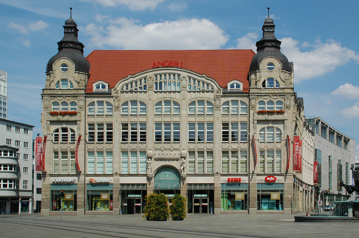
The Anger 1 shopping gallery is a shopping centre at the north-eastern end of the Anger in the centre of Erfurt and consists of an old Art Nouveau building and a modern new building with a multi-storey car park.
Sight 20: Kaufmannskirche - Sankt Gregorii

The Kaufmannskirche is a church building in the historical centre of the city of Erfurt in Thuringia, Germany. It is located at the north end of Erfurt's Anger square and has been Lutheran since 1521.
Sight 21: Stadtmuseum

The Haus zum Stockfisch is an important Renaissance town house at Johannesstraße 169 in the old town of Erfurt. It was acquired by the city at the beginning of the 20th century and has been used as a museum ever since, and since 1974 it has been the seat of the city museum.
Sight 22: Kaisersaal

The Kaisersaal is a traditional cultural and congress centre in the old town of Erfurt. The Erfurt Princes' Congress of Emperors Napoleon I and Tsar Alexander I took place here in 1808 and the Erfurt party congress of the SPD in 1891. On April 12, 1946, Communists and Social Democrats passed the "Resolution on the Unification of the KPD and SPD to form the Socialist Unity Party of Germany SED" at a joint meeting at the local level in the Kaisersaal. The Kaisersaal is located in a listed ensemble at Futterstraße 15/16.
Sight 23: Ägidienkirche

St Giles' Church in the historical centre of the city of Erfurt in Thuringia, Germany, forms the eastern entrance from Wenigemarkt to the Krämerbrücke with its archway. The single-nave Gothic church building is one of the former two bridgehead churches. At the western end stood the Benediktikirche since the 11th century, which was demolished in 1890 and is now only remembered by the name of Benediktsplatz.
Sight 24: Krämerbrücke

The Krämerbrücke is a medieval arch bridge in the city of Erfurt, in Thuringia, central Germany, which is lined with half-timbered shops and houses on both sides of a cobblestone street. It is one of the few remaining bridges in the world that have inhabited buildings. It has been continuously inhabited for over 500 years, longer than any other bridge in Europe. The stone, pedestrian bridge, which dates from 1325, is one of the oldest secular structures in Erfurt. It spans the Breitstrom, a branch of Gera River, and connects two town squares – Benediktsplatz and Wenigemarkt.
Sight 25: Mikwe

The Erfurt Mikveh is a Jewish ritual bath of medieval origin in the old town of Erfurt an der Gera in the area of the Krämerbrücke. It belongs to the Erfurt Network for Jewish Life.
Sight 26: Kleine Synagoge

The Small Synagogue is a former synagogue in Erfurt, Thuringia, Germany. It is located in the old town directly on the Gera behind the town hall and has been used as a cultural centre since 1993.
Sight 27: Rathaus Erfurt

The Erfurt town hall is located at the fish market in Erfurt. The main building was built in the 1870s in a neo-Gothic style.
Sight 28: Alte Synagoge Erfurt

The Old Synagogue is a former Jewish congregation and synagogue, located in Erfurt, Thuringia, Germany.
Wikipedia: Old Synagogue (Erfurt) (EN), Website, Heritage Website
Sight 29: Färberwaid

Isatis tinctoria, also called woad, dyer's-weed, or glastum, is a flowering plant in the family Brassicaceae with a documented history of use as a blue dye and medicinal plant.
Sight 30: Michaeliskirche

St Michael's Church in the historical centre of the city of Erfurt in Thuringia, Germany, is a Gothic church building. It belongs to the Evangelische Stadtmission Erfurt and is the university church of the University of Erfurt.
Sight 31: Allerheiligenkirche

All Saints' Church in the city of Erfurt in Thuringia, Germany, is a small Roman Catholic church building dating from the 12th to 14th century. The Gothic hall church is located at the fork of Allerheiligenstraße and Marktstraße in the historical centre of Erfurt. It has an irregular floor plan and, at 53 metres, the highest church tower in the old part of the city. Since 2007, it has been the first Roman Catholic church in central Germany to house a columbarium.
Sight 32: Theater Waidspeicher
The Waidspeicher Theatre is a professional puppet theatre in Erfurt.
Wikipedia: Theater Waidspeicher (Puppentheater) (DE), Website
Sight 33: Kabarett Die Arche
The Thuringian satirical theatre and cabaret Die Arche e.V. was founded in Erfurt in 1979. The venue is the Erfurt Theater Waidspeicher, a former warehouse for dyer's woad.
Sight 34: Maria-Magdalenen-Kapelle
The Magdalenen Chapel is a small profaned church building in Erfurt's old town. It belongs to the cathedral community and was originally a cemetery chapel. Today it is used as a columbarium.
Sight 35: Kunsthalle Erfurt
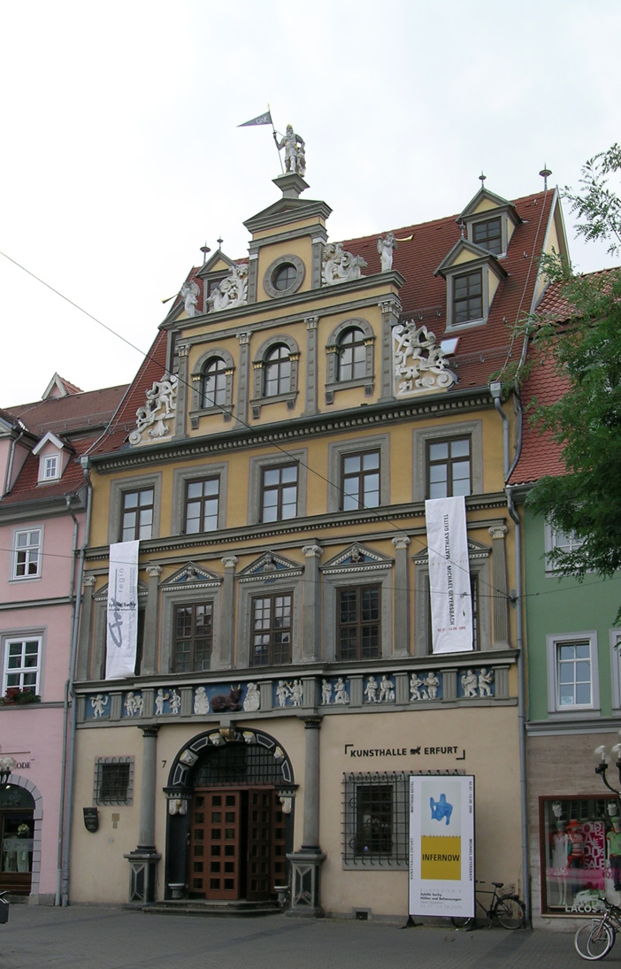
The Kunsthalle Erfurt is located in Erfurt's old town, at the fish market in the Haus zum Roten Ochsen. This is also the headquarters of the Erfurter Kunstverein.
Sight 36: Römer
The Roman is a statue in the form of a Roman warrior on the fish market in Erfurt, directly opposite the Erfurt town hall. The statue is of a Roman warrior armed from head to toe with the insignia of the Roman Republic, holding the city flag of Erfurt in his right hand.
Sight 37: Neue Mühle

The Neue Mühle is a technical museum on the Schlösserbrücke in Erfurt, Thuringia. It is located on a tributary of the small river Gera, which operates the mill's hydroelectric power plant. It contains a grain mill with an undershot Zuppinger water wheel and is the last functioning mill of 60 in the city. It has borne its name as the "New Mill" since its reconstruction after the fire of 1735. Particularly interesting is the preserved material flow over all floors by means of a belt bucket elevator. In addition to a milling process, historic roller mills, several plansifters and a mill brake elevator can be seen.
Sight 38: Barfüßerkirche

The Barfüßerkirche in the historical city centre of Erfurt in Thuringia, Germany, belonged to the most important church buildings of the city and was one of the most elaborate mendicant churches in Germany until its extensive destruction by bombing in 1944. It was mainly built in the 14th century as a monastery church of the Franciscans, who were also called Barfüßer. The choir was restored in the 1950s; beside the nave's ruin, it is situated west of the Schlösserbrücke bridge on the right bank of the Breitstrom, a branch of the Gera river.
Sight 39: Predigerkirche

The Predigerkirche is a Lutheran church in Erfurt, central Germany. It is a monastic church to the Dominican friary, Predigerkloster, adjacent to the church. The name of the Preachers' Church derives from the designation of the Dominicans as "Preacher Brothers". The Predigerkirche was originally built by the Dominican Order in the 13th century, when the mystic Meister Eckhart was prior here. The original building was modified in 1340–50, and the bell tower was built between 1447 and 1488. The church became Protestant after the Reformation. Around 1806, the Predigerkirche was used as a prisoner-of-war camp, which led to damage to the interior and the equipment. Repairs were made around 1826.
Sight 40: Erthal-Obelisk

The Erthal Obelisk is an 18-metre-high obelisk on the cathedral square in Erfurt. It was erected around 1777 on the occasion of the first visit of the Archbishop of Mainz and Erfurt city lord Friedrich Karl Joseph von Erthal, making it one of the oldest monuments in Erfurt. The construction costs were 1120 thalers, of which the citizens raised 858 in a collection. The work of a master builder who has not survived is made of Wandersleben sandstone and has a square base made of granite with a laurel-wreathed effigy, name, coat of arms and initials, orders and decorations. In earlier times, a dedication in the stone explained that the "loyal subjects of the local city to the best father of the country" had built this monument "in eternal memory".
Sight 41: Minerva

The Minerva Fountain is a fountain on the cathedral square in Erfurt, Germany.
Sight 42: Bonifatiuskapelle

St Severus' Church in the city of Erfurt in Thuringia, Germany, is a Roman Catholic church building. It stands on the Domberg directly next to St Mary's Cathedral. As a unique architectural ensemble, both churches together form the city's landmark. Due to its unusual form, which seems to anticipate the late Gothic hall church, St Severus' Church is one of the most important Gothic buildings in Germany. The bones of the church patron Severus of Ravenna rest in an artistically very significant sarcophagus.
Sight 43: Zitadelle Petersberg

Petersberg Citadel in Erfurt, central Germany, is one of the largest and best-preserved town fortresses in Europe. The citadel was built on Petersberg hill, in the north-western part of the old town centre from 1665, when Erfurt was governed by the Electorate of Mainz. It is surrounded by over two kilometres of stone walls and is 36 hectares in size.
Share
How likely are you to recommend us?
Disclaimer Please be aware of your surroundings and do not enter private property. We are not liable for any damages that occur during the tours.
GPX-Download For navigation apps and GPS devices you can download the tour as a GPX file.