Self-guided Sightseeing Tour #5 in Aachen, Germany
Legend
Guided Free Walking Tours
Book free guided walking tours in Aachen.
Guided Sightseeing Tours
Book guided sightseeing tours and activities in Aachen.
Tour Facts
4.3 km
57 m
Experience Aachen in Germany in a whole new way with our free self-guided sightseeing tour. This site not only offers you practical information and insider tips, but also a rich variety of activities and sights you shouldn't miss. Whether you love art and culture, want to explore historical sites or simply want to experience the vibrant atmosphere of a lively city - you'll find everything you need for your personal adventure here.
Individual Sights in AachenSight 1: ASEAG Kunden-Center
The Aachener Straßenbahn und Energieversorgungs-AG (ASEAG) operates local public transport in the Aachen City Region. Despite its name, it is now a pure bus company. In 2023, it transported approximately 64.209 million passengers on 118 lines in an area of 770 km². This makes it the largest German transport company that relies solely on buses. The length of the line network is 1981.6 km. The ASEAG network is integrated into the Aachener Verkehrsverbund (AVV).
Wikipedia: Aachener Straßenbahn und Energieversorgungs-AG (DE), Website
Sight 2: Altes Kurhaus

The Old Kurhaus of Aachen was built between 1782 and 1786 according to designs by Jakob Couven at Komphausbadstraße 19 as a Neue Redoute and an extension to the neighboring Alte Redoute Aachen at number 11. In contrast to the Old Kurhaus, the Kurhaus at Monheimsallee 44, which was inaugurated in 1916, is referred to as the Neues Kurhaus Aachen, which also housed the Aachen Casino until 11 June 2015.
Sight 3: Röhrenbrunnen

The Röhrenbrunnen is a fountain in Aachen, Germany. It is located on a triangular square between Komphausbadstraße and Kurhausstraße north of the Old Kurhaus. The fountain was created in 1971 by the sculptor Heinz Tobolla.
Sight 4: Londoner Hof

The former London Court was a representative three-winged city villa from the 18th century built by Laurenz Mefferdatis at Kleinkölnstraße 18 in Aachen's city centre, whose actual origins lie in the 15th century. Of the current commercial building standing there, only the ground floor original from the time of Mefferdatis and the approx. 1700 m² floor plan have been preserved, whereupon the building was placed under monument protection in 1977.
Sight 5: St. Nikolaus
The church of St. Nikolaus in Aachen is a former monastery church of the Franciscan order. It stands at the intersection of Großkölnstraße - Minoritenstraße in the immediate vicinity of the Barbarosamauer, the inner city wall of Aachen. A first church there is mentioned in 1005; It was an early church in which Nicholas of Myra was worshiped. Today's church was built in the first half of the 14th century. The building is under monument protection.
Sight 6: Karlshofbrunnen

The Karlshof Fountain is located in Aachen, North Rhine-Westphalia in the courtyard of the Karlshof in the immediate vicinity of Aachen's market square.
Sight 7: Karlsbrunnen

The statue of Charlemagne is a prominent public sculpture representing Charlemagne in Aachen. It was first erected in 1620 on the Marktplatz in front of Aachen Town Hall, as part of the monumental Karlsbrunnen fountain. The statue now standing on the Karlsbrunnen is a 1969 copy, and the original has been kept since 2014 at the nearby Centre Charlemagne museum. It has become the most popular image of Charlemagne in the monarch's chosen capital of Aachen.
Sight 8: Haus Löwenstein

The building known as Haus Löwenstein at Markt No. 41, on the corner of Pontstraße in Aachen, was built parallel to Aachen's town hall and completed around 1344. Along with the cathedral and town hall, it is one of the few Gothic buildings that survived the great city fire of 1656.
Sight 9: International Newspaper Museum

The International Newspaper Museum in Aachen presents the history of newspapers and the topic of press history.
Sight 10: Großes Haus von Aachen

The Great House of Aachen is one of the oldest surviving residential buildings in the city of Aachen. Its significance as an architectural monument lies in the fact that it survived the Aachen city fire of 1656 largely undamaged. The building now houses the International Newspaper Museum.
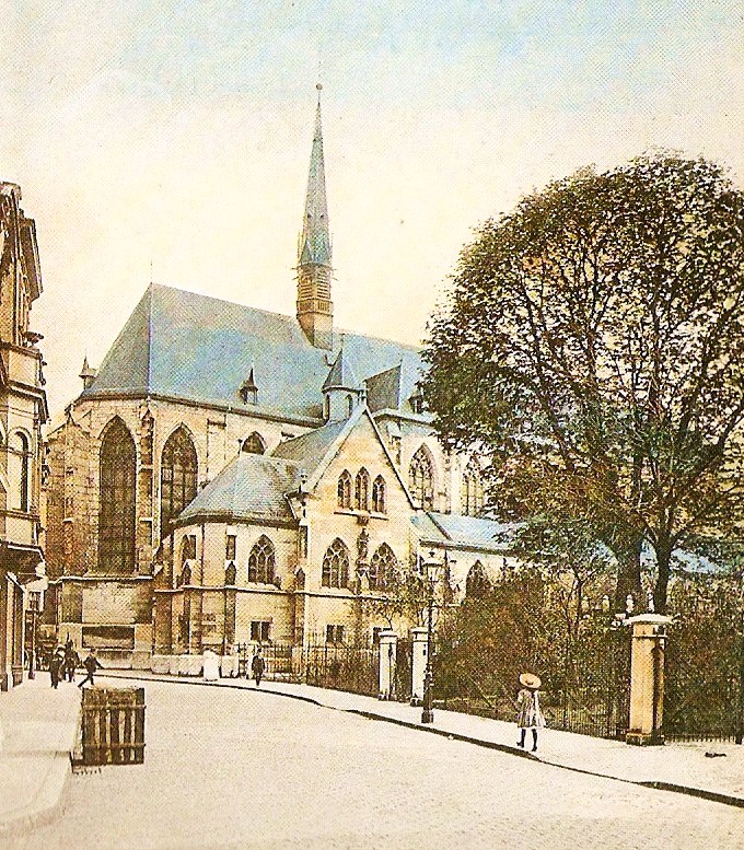
Sight 11: Theresienkirche

The Theresienkirche is a Catholic city church in Aachen, Germany. It is located in the northeastern area of the city center and borders on the building areas of the RWTH Aachen University. It is owned by the state of North Rhine-Westphalia as a special property.
Sight 12: Aula Carolina

The Aula Carolina is a listed building that is available for both school gatherings and public cultural events. It is located at the southern end of Pontstraße in the center of Aachen. The auditorium belonging to the eponymous Kaiser-Karls-Gymnasium is the former church of St. Katharina of the former monastery of the Augustinian hermits.
Sight 13: Torbogen des Klosterather Hofs

The Klosterrather Hof, also known as the Klosterrather Refugium or Kirchrather Hof, was a former monastery courtyard and later a residential and manufacturing complex in the Eilfschornsteinstraße in Aachen.
Sight 14: Reiff-Museum

The Reiff Museum was a museum in Aachen, Germany. The museum was founded by Franz Reiff (1835–1902); because from the founding of RWTH Aachen University in 1870 as the "Royal Rhine-Westphalian Polytechnic School of Aachen", there was also a painting professorship, which was located in the Department of Architecture; the positions were held (successively): Franz Reiff, Alexander Frenz, August von Brandis, Hermann Haas. The collection of works of art served to train architects and art historians at the Polytechnic Technical University. Today, only part of the existing building has been preserved. The building refers to its original use via a cartouche with the inscription Reiff Museum. The original collection rooms on the 2nd floor have had a different use since the 1950s. The building houses the Faculty of Architecture at RWTH Aachen University. The collection has been stored in a basement depot since 2012 and cannot be visited.
Sight 15: Lochner-Tor

Emil Lochner was an Aachen cloth manufacturer and made a significant contribution to the cityscape of Aachen. Lochnerstraße in Aachen is named after his father.
Sight 16: Pfaffenturm

The Pfaffenturm was a defensive tower of the outer city wall of the city of Aachen, which was built around 1300 to 1350. It is one of the few surviving towers of the former city fortifications.
Sight 17: Westpark

The Westpark is a park in the west of Aachen, which is bounded by Gartenstraße, Welkenrather Straße and Vaalser Straße.
Share
How likely are you to recommend us?
Disclaimer Please be aware of your surroundings and do not enter private property. We are not liable for any damages that occur during the tours.
GPX-Download For navigation apps and GPS devices you can download the tour as a GPX file.