Self-guided Sightseeing Tour #7 in Toronto, Canada
Legend
Guided Free Walking Tours
Book free guided walking tours in Toronto.
Guided Sightseeing Tours
Book guided sightseeing tours and activities in Toronto.
Tour Facts
9.3 km
187 m
Experience Toronto in Canada in a whole new way with our free self-guided sightseeing tour. This site not only offers you practical information and insider tips, but also a rich variety of activities and sights you shouldn't miss. Whether you love art and culture, want to explore historical sites or simply want to experience the vibrant atmosphere of a lively city - you'll find everything you need for your personal adventure here.
Activities in TorontoIndividual Sights in TorontoSight 1: Oakham House

Oakham House is a historic building in Toronto, Ontario, Canada. The house is located at the southwest corner of Gould and Church streets. It was designed by architect William Thomas as his own residence and office, and completed in 1848. Today, it is owned by Toronto Metropolitan University. The upper level consists of a cafe used by students and faculty, while the lower level is home to a student pub. The building is also used by the university to hold events and receptions.
Sight 2: Mackenzie House
Get Ticket*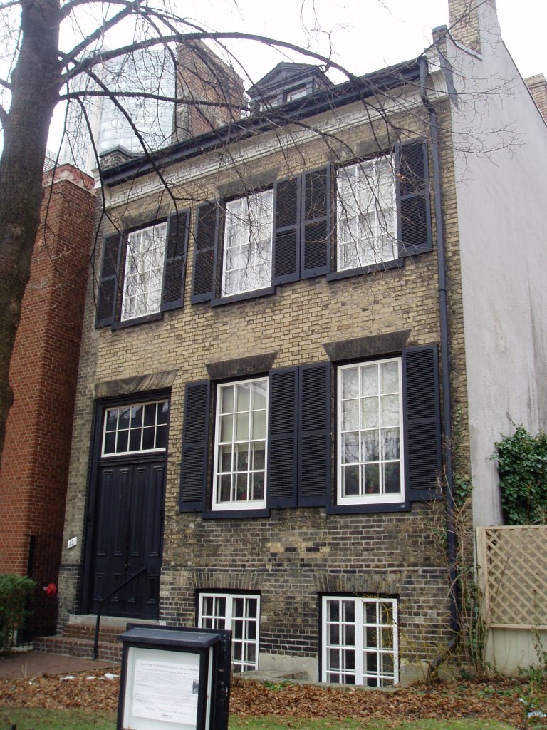
Mackenzie House is a historic building and museum in Toronto, Ontario, Canada that was the last home of William Lyon Mackenzie, the city's first mayor. It is now a museum operated by the City of Toronto's Museum and Heritage Services.
Sight 3: Saint Michael's Cathedral Basilica

St. Michael's Cathedral Basilica is the cathedral church of the Roman Catholic Archdiocese of Toronto, Canada, and one of the oldest churches in Toronto. It is located at 65 Bond Street in Toronto's Garden District. St. Michael's was designed by William Thomas, designer of eight other churches in the city, and was primarily financed by Irish immigrants who resided in the area. The cathedral has a capacity of 1600. John Cochrane and Brothers undertook the work on the stone and stucco ornamentation of the interior.
Sight 4: Metropolitan United Church

Metropolitan United Church is a historic Neo-Gothic style church in downtown Toronto, Ontario, Canada. It is one of the largest and most prominent churches of the United Church of Canada. It is located at 56 Queen Street East, between Bond and Church streets, in Toronto's Garden District.
Sight 5: Massey Hall

Massey Hall is a performing arts theatre in Toronto, Ontario, Canada. Opened in 1894, it is known for its outstanding acoustics and was the long-time hall of the Toronto Symphony Orchestra. An intimate theatre, it was originally designed to seat 3,500 patrons, but after extensive renovations in the 1940s, it now seats only up to 2,765. It has an extensive history of concerts by artists of many musical genres which continues today.
Sight 6: Ed Mirvish Theatre

The Ed Mirvish Theatre is a historic performing arts theatre in Toronto, Ontario, located near Yonge–Dundas Square. Owned and operated by Mirvish Productions, the theatre has approximately 2,300 seats across two levels. There are two entrances to the theatre, located at 263 Yonge Street and 244 Victoria Street.
Sight 7: Yonge-Dundas Square
Get Ticket*
Yonge–Dundas Square, or Dundas Square is a public square at the southeast corner of the intersection of Yonge Street and Dundas Street East in Downtown Toronto, Ontario, Canada. Designed by Brown and Storey Architects, the square was conceived in 1997 as part of revitalizing the intersection. Since its completion in 2002, the square has hosted many public events, performances and art displays, establishing itself as a prominent landmark in Toronto and one of the city's prime tourist attractions. Central to the Downtown Yonge entertainment and shopping district, the square is owned by the city and is the first public square in Canada to be maintained through a public–private partnership. The intersection is one of the busiest in Canada, with over 100,000 people crossing the city's first pedestrian scramble daily.
Sight 8: Trinity Square

Trinity Square is a public square in downtown Toronto, Ontario, Canada. It is bounded on the east by the Toronto Eaton Centre, on the south and west by the Bell Trinity Square office complex, and on the north by the Marriott Downtown Eaton Centre hotel.
Sight 9: Church of the Holy Trinity
Get Ticket*
The Church of the Holy Trinity is an Anglican church located at Trinity Square in Toronto, Ontario, Canada.
Wikipedia: Church of the Holy Trinity (Toronto) (EN), Website
Sight 10: Elgin & Winter Garden Theatres

The Elgin & Winter Garden Theatres are a pair of stacked theatres in Toronto, Ontario, Canada. The Winter Garden Theatre is seven storeys above the Elgin Theatre. They are the last surviving Edwardian stacked theatres in the world.
Sight 11: Old City Hall Cenotaph

The Old City Hall Cenotaph is a cenotaph located at the front steps of Old City Hall in Toronto, Ontario, Canada.
Sight 12: TORONTO

The Toronto Sign is an illuminated three-dimensional sign in Nathan Phillips Square in Toronto, Ontario, Canada, that spells the city's name. It is 3 metres (9.8 ft) tall and 22 metres (72 ft) long, lit by LED lights that can create an estimated 228 million colour combinations.
Sight 13: Nathan Phillips Square
Get Ticket*
Nathan Phillips Square is an urban plaza in Toronto, Ontario, Canada. It forms the forecourt to Toronto City Hall, or New City Hall, at the intersection of Queen Street West and Bay Street, and is named after Nathan Phillips, mayor of Toronto from 1955 to 1962. The square was designed by the City Hall's architect Viljo Revell and landscape architect Richard Strong. It opened in 1965. The square is the site of concerts, art displays, a weekly farmers' market, the winter festival of lights, and other public events, including demonstrations. During the winter months, the reflecting pool is converted into an ice rink for ice skating. The square attracts an estimated 1.5 million visitors yearly. With an area of 4.85 hectares, it is Canada's largest city square.
Sight 14: Four Seasons Centre for the Performing Arts

The Four Seasons Centre for the Performing Arts is a 2,071-seat theatre in Toronto, Ontario, Canada, located at the southeast corner of University Avenue and Queen Street West, across from Osgoode Hall. The land on which it is located was a gift from the Government of Ontario. It is the home of the Canadian Opera Company (COC) and the National Ballet of Canada. The building's modernist design by was created by Canadian firm Diamond Schmitt Architects, headed by Jack Diamond. It was completed in 2006, and the interior design includes an unusual glass staircase.
Sight 15: Campbell House

Campbell House is an 1822 heritage house and museum in downtown Toronto, Ontario, Canada. It was built for Upper Canada Chief Justice Sir William Campbell and his wife Hannah. The home was designed for entertaining and comfort, and constructed at a time when the Campbells were socially and economically established and their children had grown to adulthood. The house is one of the few remaining examples of Georgian architecture left in Toronto and is constructed in a style in vogue during the late Georgian era known as Palladian architecture.
Sight 16: Textile Museum Of Canada

The Textile Museum of Canada, located in Toronto, Ontario, Canada, is a museum dedicated to the collection, exhibition, and documentation of textiles.
Sight 17: St. Patrick's Catholic Church

St. Patrick's Roman Catholic Church on McCaul Street in Toronto, Ontario, Canada, is the church for the city's fifth oldest Roman Catholic parish. St. Patrick subway station nearby and the adjacent St. Patrick Street were named after the church. St. Patrick's is the home of the Canadian National Shrine of Our Mother of Perpetual Help. The German-speaking Catholic community in Toronto holds services in the church as well.
Sight 18: Couch Monster: Sadzěʔ yaaghęhch’ill
Sight 19: Art Gallery of Ontario
Get Ticket*The Art Gallery of Ontario is an art museum in Toronto, Ontario, Canada, located in the Grange Park neighbourhood of downtown Toronto, on Dundas Street West. The building complex takes up 45,000 square metres (480,000 sq ft) of physical space, making it one of the largest art museums in North America and the second-largest art museum in Toronto, after the Royal Ontario Museum. In addition to exhibition spaces, the museum also houses an artist-in-residence office and studio, dining facilities, event spaces, gift shop, library and archives, theatre and lecture hall, research centre, and a workshop.
Sight 20: Grange Park

Grange Park is a prominent and well-used public park in downtown Toronto, Ontario in Canada. It is located south of the Art Gallery of Ontario, next to the Ontario College of Art and Design University (OCADU) and north of University Settlement House, at the north end of John Street. The Park lends its name to the Grange Park neighbourhood in the vicinity of the park. Historically, the park was the backyard of The Grange, a manor that was later expanded and became the Art Gallery of Ontario.
Sight 21: Toronto Chinese Baptist Church

The Toronto Chinese Baptist Church is a Baptist church serving the Chinese-Canadian community of Toronto, Ontario, Canada. It is affiliated with Canadian Baptists of Ontario and Quebec.
Sight 22: George Brown House

George Brown House is a historic building in the Grange Park neighbourhood of Toronto, Ontario, Canada. It was home to Father of Confederation, Reform Party politician and publisher George Brown. Its current address is 186 Beverley Street.
Sight 23: Anshei Minsk Synagogue

Anshei Minsk is a synagogue in the Kensington Market neighbourhood of Toronto, Ontario, Canada. It was founded in 1912 by poor Jewish immigrants from what is now Belarus, which at the time was part of the Russian Empire. The current Byzantine Revival building was completed in 1930.
Sight 24: Alexandra Park

Alexandra Park is a neighbourhood located in downtown Toronto, Ontario, Canada. Alexandra Park is bounded by Dundas Street West on the north, Spadina Avenue on the east, Queen Street West on the south, and Bathurst Street on the west. Alexandra Park consists of private and public housing, with at grade retail along Queen Street West and Spadina Avenue, some institutional, and several commercial buildings scattered through the neighborhood. The neighborhood takes its name from Alexandra Park, a municipal park at the south-east corner of Dundas Street West and Bathurst Street. The park is named for Queen Alexandra, whose husband, King Edward VII, was the first future monarch to visit Toronto.
Sight 25: Theatre Passe Muraille
Sight 26: Factory Theatre

Factory Theatre is a theatre in Toronto, Ontario, Canada. It was founded as Factory Theatre Lab in 1970 by Ken Gass and Frank Trotz, and it was run for almost 20 years by Dian English.
Sight 27: St. Andrew's Playground
St. Andrew's Playground is a small park in downtown Toronto. It is located at the 450 Adelaide Street West, at the northwest corner of Brant St and Adelaide. It has a playground for children and an off-leash area for dogs that is surrounded by a short fence, with an accessible water fountain for pets, children, and adults. A Heritage Toronto plaque in the northwest corner describing the history and significance of the park was installed in 2007.
Sight 28: Clarence Square

Clarence Square is a small park in downtown Toronto, Ontario, Canada, where Wellington Street West meets Spadina Avenue. It is a relatively quiet and shady park, with many large trees and a spacious grassy terrain. There are several benches and picnic tables scattered throughout and a drinking fountain in the centre.
Sight 29: Royal Alexandra Theatre

The Royal Alexandra Theatre, commonly known as the Royal Alex, is an historic performing arts theatre in Toronto, Ontario. The theatre is located at 260 King Street West, in the downtown Toronto Entertainment District. Owned and operated by Mirvish Productions, the theatre has approximately 1,244 seats across three levels. Built in 1907, the Royal Alexandra Theatre is the oldest continuously operating legitimate theatre in North America.
Share
How likely are you to recommend us?
Disclaimer Please be aware of your surroundings and do not enter private property. We are not liable for any damages that occur during the tours.
GPX-Download For navigation apps and GPS devices you can download the tour as a GPX file.