100 Sights in Toronto, Canada (with Map and Images)
Legend
Premium Sights
Book tickets, guided tours and activities in Toronto.
Guided Free Walking Tours
Book free guided walking tours in Toronto.
Welcome to your journey through the most beautiful sights in Toronto, Canada! Whether you want to discover the city's historical treasures or experience its modern highlights, you'll find everything your heart desires here. Be inspired by our selection and plan your unforgettable adventure in Toronto. Dive into the diversity of this fascinating city and discover everything it has to offer.
Sightseeing Tours in TorontoActivities in TorontoThe Hockey Hall of Fame is a museum and hall of fame located in Toronto, Ontario, Canada. Dedicated to the history of ice hockey, it holds exhibits about players, teams, National Hockey League (NHL) records, memorabilia and NHL trophies, including the Stanley Cup. Founded in Kingston, Ontario, the Hockey Hall of Fame was established in 1943 under the leadership of James T. Sutherland. The first class of honoured members was inducted in 1945, before the Hall of Fame had a permanent location. It moved to Toronto in 1958 after the NHL withdrew its support for the International Hockey Hall of Fame in Kingston, Ontario, due to funding issues. Its first permanent building opened at Exhibition Place in 1961. The hall was relocated in 1993, and is now in Downtown Toronto, inside Brookfield Place, and a historic Bank of Montreal building. The Hockey Hall of Fame has hosted International Ice Hockey Federation (IIHF) exhibits and the IIHF Hall of Fame since 1998.

Nathan Phillips Square is an urban plaza in Toronto, Ontario, Canada. It forms the forecourt to Toronto City Hall, or New City Hall, at the intersection of Queen Street West and Bay Street, and is named after Nathan Phillips, mayor of Toronto from 1955 to 1962. The square was designed by the City Hall's architect Viljo Revell and landscape architect Richard Strong. It opened in 1965. The square is the site of concerts, art displays, a weekly farmers' market, the winter festival of lights, and other public events, including demonstrations. During the winter months, the reflecting pool is converted into an ice rink for ice skating. The square attracts an estimated 1.5 million visitors yearly. With an area of 4.85 hectares, it is Canada's largest city square.
The Art Gallery of Ontario is an art museum in Toronto, Ontario, Canada, located in the Grange Park neighbourhood of downtown Toronto, on Dundas Street West. The building complex takes up 45,000 square metres (480,000 sq ft) of physical space, making it one of the largest art museums in North America and the second-largest art museum in Toronto, after the Royal Ontario Museum. In addition to exhibition spaces, the museum also houses an artist-in-residence office and studio, dining facilities, event spaces, gift shop, library and archives, theatre and lecture hall, research centre, and a workshop.

Berczy Park is a small park in downtown Toronto, Ontario, Canada. The park is triangular in shape, bounded by Scott Street, Front Street and Wellington Street. The park is bordered at its eastern tip, where Wellington and Front join, by the Gooderham Building, a heritage building that is an example of a "flatiron building". A widely admired mural graces the western facade of the building.

The CN Tower is a 553.3 m-high (1,815.3 ft) concrete communications and observation tower in Toronto, Ontario, Canada. Completed in 1976, it is located in downtown Toronto, built on the former Railway Lands. Its name "CN" referred to Canadian National, the railway company that built the tower. Following the railway's decision to divest non-core freight railway assets prior to the company's privatization in 1995, it transferred the tower to the Canada Lands Company, a federal Crown corporation responsible for the government's real estate portfolio.
Mackenzie House is a historic building and museum in Toronto, Ontario, Canada that was the last home of William Lyon Mackenzie, the city's first mayor. It is now a museum operated by the City of Toronto's Museum and Heritage Services.
The Royal Ontario Museum (ROM) is a museum of art, world culture and natural history in Toronto, Ontario, Canada. It is one of the largest museums in North America and the largest in Canada. It attracts more than one million visitors every year, making it the most-visited museum in Canada. It is north of Queen's Park, in the University of Toronto district, with its main entrance on Bloor Street West. Museum subway station is named after it and, since a 2008 renovation, is decorated to resemble the ROM's collection at the platform level; Museum station's northwestern entrance directly serves the museum.

Yonge–Dundas Square, or Dundas Square is a public square at the southeast corner of the intersection of Yonge Street and Dundas Street East in Downtown Toronto, Ontario, Canada. Designed by Brown and Storey Architects, the square was conceived in 1997 as part of revitalizing the intersection. Since its completion in 2002, the square has hosted many public events, performances and art displays, establishing itself as a prominent landmark in Toronto and one of the city's prime tourist attractions. Central to the Downtown Yonge entertainment and shopping district, the square is owned by the city and is the first public square in Canada to be maintained through a public–private partnership. The intersection is one of the busiest in Canada, with over 100,000 people crossing the city's first pedestrian scramble daily.

The Bata Shoe Museum (BSM) is a museum of footwear and calceology in Toronto, Ontario, Canada. The museum's building is situated near the northwest of the University of Toronto's St. George campus, in downtown Toronto. The 3,665-square-metre (39,450 sq ft) museum building was designed by Moriyama & Teshima Architects, with Raymond Moriyama as the lead architect.
10. Distillery District

The Distillery District is a commercial and residential district in Toronto, Ontario, Canada, east of downtown, which contains numerous cafés, restaurants, and shops housed within heritage buildings of the former Gooderham and Worts Distillery. The 13 acres (5.3 ha) district comprises more than forty heritage buildings and ten streets, and is the largest collection of Victorian-era industrial architecture in North America.
11. TORONTO

The Toronto Sign is an illuminated three-dimensional sign in Nathan Phillips Square in Toronto, Ontario, Canada, that spells the city's name. It is 3 metres (9.8 ft) tall and 22 metres (72 ft) long, lit by LED lights that can create an estimated 228 million colour combinations.
12. Monument to Multiculturalism
Multiculturalism is the coexistence of multiple cultures. The word is used in sociology, in political philosophy, and colloquially. In sociology and everyday usage, it is usually a synonym for ethnic or cultural pluralism in which various ethnic and cultural groups exist in a single society. It can describe a mixed ethnic community area where multiple cultural traditions exist or a single country. Groups associated with an indigenous, aboriginal or autochthonous ethnic group and settler-descended ethnic groups are often the focus.
13. Frederick Banting
Sir Frederick Grant Banting was a Canadian pharmacologist, orthopedist, and field surgeon. For his co-discovery of insulin and its therapeutic potential, Banting was awarded the Nobel Prize in Physiology or Medicine with John Macleod.
14. Toronto Zoo

The Toronto Zoo is a zoo located in Toronto, Ontario, Canada. Encompassing 287 hectares, the Toronto Zoo is the largest zoo in Canada averaging around 1.2 million visitors a year. The zoo is divided into seven zoogeographic regions: Indo-Malaya, Africa, Americas, Tundra Trek, Australasia, Eurasia, and the Canadian Domain. Some animals are displayed indoors in pavilions and outdoors in what would be their naturalistic environments, with viewing at many levels. The zoo also has areas such as the Kids Zoo, Waterside Theatre, and Splash Island. The zoo has one of the most taxonomically diverse collection of animals on display of any zoo worldwide and is currently home to over 3,000 animals representing over 300 species. The zoo is open to the public every day of the year.
15. Casa Loma

Casa Loma is a Gothic Revival castle-style mansion and garden in midtown Toronto, Ontario, Canada, that is now a historic house museum and landmark. It was constructed from 1911 to 1914 as a residence for financier Sir Henry Pellatt. The architect was E. J. Lennox, who designed several other city landmarks. Casa Loma sits at an elevation of 140 metres (460 ft) above sea level, 66 metres (217 ft) above Lake Ontario.
16. High Park

High Park is a municipal park in Toronto, Ontario, Canada. High Park is a mixed recreational and natural park, with sporting facilities, cultural facilities, educational facilities, gardens, playgrounds and a zoo. One-third of the park remains in a natural state, with a rare oak savannah ecology. High Park was opened to the public in 1876 and is based on a bequest of land from John George Howard to the City of Toronto. It spans 161 hectares and is one of the largest parks in Toronto.
17. Massey Hall

Massey Hall is a performing arts theatre in Toronto, Ontario, Canada. Opened in 1894, it is known for its outstanding acoustics and was the long-time hall of the Toronto Symphony Orchestra. An intimate theatre, it was originally designed to seat 3,500 patrons, but after extensive renovations in the 1940s, it now seats only up to 2,765. It has an extensive history of concerts by artists of many musical genres which continues today.
18. Cathedral Church of St. James

The Cathedral Church of St. James is an Anglican cathedral in Downtown Toronto, Ontario, Canada. It is the location of the oldest congregation in the city, with the parish being established in 1797. The church, the fourth on the site, began construction in 1850 and opened for services on June 19, 1853. It was one of the largest buildings in the city at that time. It was designed by Frederick William Cumberland and is an example of Gothic Revival architecture.
19. Toronto Magnetic and Meteorological Observatory

The Toronto Magnetic and Meteorological Observatory is a historical observatory located on the grounds of the University of Toronto, in Toronto, Ontario, Canada. The original building was constructed in 1840 as part of a worldwide research project run by Edward Sabine to determine the cause of fluctuations in magnetic declination. Measurements from the Toronto site demonstrated that sunspots were responsible for this effect on Earth's magnetic field. When this project concluded in 1853, the observatory was greatly expanded by the Canadian government and served as the country's primary meteorological station and official timekeeper for over fifty years. The observatory is considered the birthplace of Canadian astronomy.
Wikipedia: Toronto Magnetic and Meteorological Observatory (EN)
20. University College
University College, popularly referred to as UC, is a constituent college of the University of Toronto, created in 1853 specifically as an institution of higher learning free of religious affiliation. It was the founding member of the university's modern collegiate system, and its non-denominationalism contrasted with contemporary colleges at the time, such as Trinity College and St. Michael's College, both of which later became part of the University of Toronto.
21. Downsview Park
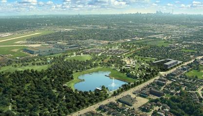
Downsview Park (French: Parc Downsview) is a large urban park located in the Downsview neighbourhood of Toronto, Ontario, Canada. The park's name is officially bilingual due to it being federally owned and managed, and was first home to de Havilland Canada, an aircraft manufacturer, and later was a Canadian Forces base. The park still contains Downsview Airport. In 1999, the Government of Canada declared it as "Canada's first urban national park". However, unlike the Rouge National Urban Park in eastern Toronto, Downsview Park is managed by the federal Crown corporation Canada Lands Company rather than Parks Canada.
22. Ed Mirvish Theatre

The Ed Mirvish Theatre is a historic performing arts theatre in Toronto, Ontario, located near Yonge–Dundas Square. Owned and operated by Mirvish Productions, the theatre has approximately 2,300 seats across two levels. There are two entrances to the theatre, located at 263 Yonge Street and 244 Victoria Street.
23. Centreville
The Centreville Amusement Park is a children's amusement park located on Middle Island, part of the Toronto Islands, offshore of Toronto, Ontario, Canada. The park has been operated by the Beasley family since 1967, currently through Etobicoke-based William Beasley Enterprises Limited, on land leased from the City of Toronto government and is open daily during the summer. Beasley also operates the "Far Enough Farm" adjacent to the park.
24. Saint Thomas's Anglican Church

St. Thomas's Church, Huron Street is a parish of the Anglican Church of Canada in Toronto, Ontario. One of the earliest Anglo-Catholic congregations in Canada, it was established in 1874, moving twice before settling into its present building, adjacent to the Annex on the western edge of the University of Toronto's downtown campus.
Wikipedia: St. Thomas's Anglican Church (Toronto) (EN), Website
25. Aga Khan Museum

The Aga Khan Museum is a museum of Islamic art located at 77 Wynford Drive in the North York district of Toronto, Ontario, Canada. The museum is dedicated to Islamic art and objects, and it houses approximately 1,200 rare objects assembled by Shah Karim al-Husayni and Prince Sadruddin Aga Khan. As an initiative of the Aga Khan Trust for Culture, an agency of the Aga Khan Development Network, the museum is dedicated to sparking wonder, curiosity, and understanding of Muslim cultures and their connection with other cultures through the arts. In addition to the Permanent Collection, the Aga Khan Museum features several temporary exhibitions each year that respond to current scholarship, emerging themes, and new artistic developments. The Museum Collection and exhibitions are complemented by educational programs and performing arts events.
26. Four Seasons Centre for the Performing Arts

The Four Seasons Centre for the Performing Arts is a 2,071-seat theatre in Toronto, Ontario, Canada, located at the southeast corner of University Avenue and Queen Street West, across from Osgoode Hall. The land on which it is located was a gift from the Government of Ontario. It is the home of the Canadian Opera Company (COC) and the National Ballet of Canada. The building's modernist design by was created by Canadian firm Diamond Schmitt Architects, headed by Jack Diamond. It was completed in 2006, and the interior design includes an unusual glass staircase.
27. Gooderham Building

The Gooderham Building, also known as the Flatiron Building, is an historic office building at 49 Wellington Street East in Toronto, Ontario, Canada. It is located on the eastern edge of the city's Financial District in the St. Lawrence neighbourhood, wedged between Front Street and Wellington Street in Downtown Toronto, where they join up to form a triangular intersection. Completed in 1892, the red-brick edifice was an early example of a prominent flatiron building.
28. Ripley's Aquarium of Canada

Ripley's Aquarium of Canada is a public aquarium in Toronto, Ontario, Canada. The aquarium is one of three aquariums owned-and-operated by Ripley Entertainment. It is located in downtown Toronto, just southeast of the CN Tower. The aquarium has 5.7 million litres of marine and freshwater habitats from across the world. The exhibits hold more than 20,000 exotic sea and freshwater specimens from more than 450 species.
29. Gibraltar Point Lighthouse

The Gibraltar Point Lighthouse is a lighthouse located on Hanlan's Point, the most westerly of the Toronto Islands in Toronto, Ontario, Canada. Begun in 1808, it is the oldest existing lighthouse on the Great Lakes, and one of Toronto's oldest buildings. The lighthouse is perhaps best known for the demise of its first keeper, German-born John Paul Radelmüller, whose 1815 murder forms the basis of Toronto's most enduring ghost story. Recent research has verified many aspects of the traditional tale of his death and identified the soldiers charged with but ultimately acquitted of the crime.
30. Spadina Museum

Spadina Museum, also known as Spadina House, is a historic mansion at 285 Spadina Road in Toronto, Ontario, which is now a historic house museum operated by the City of Toronto's Economic Development & Culture division. The museum preserves the house much as it existed and developed historically. The art, decor and architecture of the house used to reflect the contemporary styles of the 1860s through the 1930s, including Victorian, Edwardian, Arts and Crafts, Art Nouveau, Art Deco and Colonial Revival styles. The museum closed for a year for extensive interior and exterior renovations. When it re-opened to the public on October 24, 2010, it was decorated in the style of the inter-war era of the 1920s and 1930s. The estate's gardens reflect the landscape during the Austin family's occupation of the house.
31. Royal Alexandra Theatre

The Royal Alexandra Theatre, commonly known as the Royal Alex, is an historic performing arts theatre in Toronto, Ontario. The theatre is located at 260 King Street West, in the downtown Toronto Entertainment District. Owned and operated by Mirvish Productions, the theatre has approximately 1,244 seats across three levels. Built in 1907, the Royal Alexandra Theatre is the oldest continuously operating legitimate theatre in North America.
32. BAPS Shri Swaminarayan

BAPS Shri Swaminarayan Mandir is a Hindu temple in Toronto, Ontario, that was built by the BAPS Swaminarayan Sanstha. The BAPS Swaminarayan Sanstha, which is headed by Mahant Swami Maharaj, is a global spiritual organization within the Swaminarayan branch of Hinduism. The mandir was built in 18 months and consists of 24,000 pieces of hand-carved Italian carrara marble, Turkish limestone and Indian pink stone. The mandir is the largest of its kind in Canada and was constructed according to guidelines outlined in ancient Hindu scriptures. The grounds spread over 7.3 hectares and in addition to the mandir, include a haveli and the Heritage Museum. The mandir is open daily to visitors and for worship. On June 26, 2023, the temple celebrated its 16-year anniversary.
33. Allan Gardens

Allan Gardens is a conservatory and urban park located in the Garden District of Toronto, Ontario, Canada. The property includes a playground, off-leash dog park, and a 1,500 square metres (16,000 sq ft) conservatory with six green houses.
34. Elgin & Winter Garden Theatres

The Elgin & Winter Garden Theatres are a pair of stacked theatres in Toronto, Ontario, Canada. The Winter Garden Theatre is seven storeys above the Elgin Theatre. They are the last surviving Edwardian stacked theatres in the world.
35. Christie Pits Park

Christie Pits is a public recreational area in Toronto, Ontario, Canada. It is located at 750 Bloor Street West at Christie Street, just west of the Toronto Transit Commission's Christie subway station.
36. Scarborough Bluffs

The Scarborough Bluffs, also known as The Bluffs, is an escarpment in the Scarborough district of Toronto, Ontario, Canada. There are nine parks along the bluffs, with Bluffers Park being the only one with a beach. Forming much of the eastern portion of Toronto's waterfront, the Scarborough Bluffs stands above the shoreline of Lake Ontario. At its highest point, the escarpment rises 90 metres (300 ft) above the coastline and spans a length of 15 kilometres (9.3 mi).
37. Roundhouse Park

Roundhouse Park is a 17-acre (6.9 ha) park in the downtown core of Toronto, Ontario, Canada. It is in the former Railway Lands. It features the John Street Roundhouse, a preserved locomotive roundhouse that houses the Toronto Railway Museum, Steam Whistle Brewing, and the Rec Room restaurant and entertainment complex. The park is also home to a collection of trains, the former Canadian Pacific Railway Don Station, and the Roundhouse Park Miniature Railway. The park is bounded by Bremner Boulevard, Lower Simcoe Street, Lake Shore Boulevard West/Gardiner Expressway, and Rees Street.
38. Roy Thomson Hall

Roy Thomson Hall is a concert hall in Toronto, Ontario, Canada. Located downtown in the city's entertainment district, it is home to the Toronto Symphony Orchestra, the Toronto Mendelssohn Choir, and the esports team Toronto Defiant. Opened in 1982, its circular architectural design exhibits a sloping and curvilinear glass exterior. It was designed by Canadian architects Arthur Erickson and Mathers and Haldenby. Itzhak Perlman acted as a special advisor to the architects on accessibility needs for disabled performers and guests.
39. Gardiner Museum
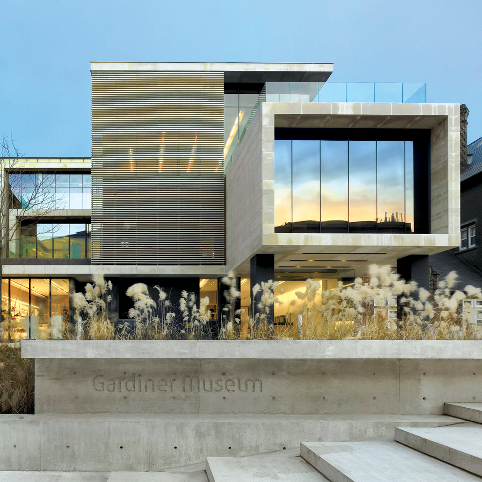
The George R. Gardiner Museum of Ceramic Art is a ceramics museum in Toronto, Ontario, Canada. The museum is situated within University of Toronto's St. George campus, in downtown Toronto. The 4,299.2-square-metre (46,276 sq ft) museum building was designed by Keith Wagland, with further expansions and renovations done by KPMB Architects.
40. Princess of Wales Theatre

The Princess of Wales Theatre is a 2,000-seat live theatre in Toronto, Ontario, Canada. It is located on King Street West, in Toronto's downtown Entertainment District. The theatre's name has a triple meaning: it honours Diana, Princess of Wales, with whose consent the theatre was named; it links the building to its sister theatre, the Royal Alexandra, one block to the east, also named – with Royal assent – for a former Princess of Wales; and it recalls the Princess Theatre, Toronto's first "first-class legitimate" playhouse, that stood three blocks to the east until 1931.
41. Design Exchange

The Design Exchange (DX) is a Canadian event venue. It is located in Toronto's financial district in the historical Toronto Stock Exchange building, that was incorporated into a skyscraper in 1991, the Toronto-Dominion Centre. The organization operated a design museum, but this museum was closed in 2019. Since 2017, it hosts a biennial design festival, the Expo for Design, Innovation, & Technology (EDIT).
42. The Market Gallery

The St. Lawrence Market South building is a major public market building in Toronto, Ontario, Canada. It is located on the southwest corner of Front and Lower Jarvis Streets. Along with the St. Lawrence Market North and St. Lawrence Hall, it comprises the St. Lawrence Market complex. The current building was opened in 1902, incorporating the 1845 Toronto City Hall building into the structure. The building was restored during the 1970s.
43. Guild Park and Gardens

Guild Park and Gardens is a public park in the Scarborough district of Toronto, Ontario, Canada. The park was formerly the site of an artist colony and is notable for its collection of relics saved from the demolition of buildings primarily in downtown Toronto arranged akin to ancient ruins. Located on the Scarborough Bluffs, Guild Park and Gardens has an outdoor Greek stage and a 19th-century log cabin among the oldest in Toronto. The principal building in the park is the Guild Inn, a former inn and estate mansion.
44. St. Lawrence Market South

St. Lawrence Market is a major public market in Toronto, Ontario, Canada. It is located along Front Street East and Jarvis Street in the St. Lawrence neighbourhood of downtown Toronto. The public market is made up of two sites adjacent to one another west of Jarvis Street, St. Lawrence Market North, and St. Lawrence Market South. St. Lawrence Market South is situated south of Front Street East, and is bounded by The Esplanade to the south. St. Lawrence Market North is situated north of Front Street East, and is bounded by St. Lawrence Hall to the north.
45. Jarvis Street Baptist Church

The Jarvis Street Baptist Church is a Baptist church located at the intersection of Gerrard Street and Jarvis Street in downtown Toronto. One of the oldest churches in the city, its congregation was founded in 1818, and the present church constructed in 1875. It is a member of the Sovereign Grace Fellowship of Canada.
46. Holy Blossom Temple

The Holy Blossom Temple is a Reform synagogue located at 1950 Bathurst Street in Toronto, Ontario, Canada. It is the oldest Jewish congregation in Toronto. Founded in 1856, it has more than 7,000 members. W. Gunther Plaut, who died on 8 February 2012 at the age of 99, was a long time Senior Rabbi for this synagogue. Notable members and supporters include Heather Reisman and Gerald Schwartz who made donations to create the Gerald Schwartz/Heather Reisman Centre for Jewish Learning at Holy Blossom Temple.
47. Metropolitan United Church

Metropolitan United Church is a historic Neo-Gothic style church in downtown Toronto, Ontario, Canada. It is one of the largest and most prominent churches of the United Church of Canada. It is located at 56 Queen Street East, between Bond and Church streets, in Toronto's Garden District.
48. The Danforth Music Hall

The Danforth Music Hall is a music venue and event theatre on Danforth Avenue in the neighbourhood of Riverdale in Toronto, Ontario, Canada. It is served by Broadview station on the TTC's Bloor–Danforth line. The building was designated as a property of historic interest under the Ontario Heritage Act in 1985.
49. Alexandra Park

Alexandra Park is a neighbourhood located in downtown Toronto, Ontario, Canada. Alexandra Park is bounded by Dundas Street West on the north, Spadina Avenue on the east, Queen Street West on the south, and Bathurst Street on the west. Alexandra Park consists of private and public housing, with at grade retail along Queen Street West and Spadina Avenue, some institutional, and several commercial buildings scattered through the neighborhood. The neighborhood takes its name from Alexandra Park, a municipal park at the south-east corner of Dundas Street West and Bathurst Street. The park is named for Queen Alexandra, whose husband, King Edward VII, was the first future monarch to visit Toronto.
50. St. Andrew's Church

St. Andrew's Church is a historic Presbyterian church located at the corner of King Street West and Simcoe Street in the city's downtown core of Toronto, Ontario, Canada. It was designed by William George Storm in the Romanesque Revival style and completed in 1876.
51. white elephant
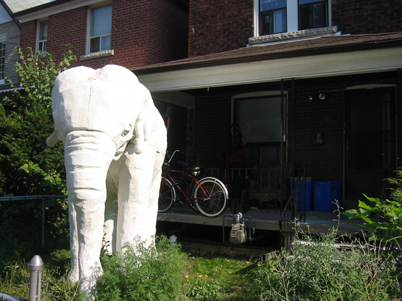
The Elephant House is a house at 77 Yarmouth Road in the Christie Pits neighbourhood of Toronto, Ontario, Canada that has a life-size plaster mammoth sculpture in the front yard. Placed there since 2003, the sculpture is titled An Elephant in the Room and was made as a student project.
52. First Russian Congregation - The Kiever Shul

The First Russian Congregation of Rodfei Sholem Anshei Kiev, known as the Kiever Synagogue or Kiever Shul, is a Modern Orthodox Jewish synagogue in Toronto, Ontario, Canada. It was founded by Jewish immigrants from Ukraine in 1912, and formally incorporated in 1914. The congregants were poor working-class people, and services were led by members and held in their homes. Two houses were eventually purchased in the Kensington Market area, and in their place construction was completed on the current twin-domed Byzantine Revival building in 1927. The building was once the site of George Taylor Denison's home Bellevue.
53. Queen's Wharf Lighthouse

The Queen's Wharf Lighthouse is a lighthouse in Toronto, Ontario, Canada, situated at Fleet Street just east of the Princes' Gates at Exhibition Place. The octagonal building was originally one of a pair of lighthouses built in 1861 at Queen's Wharf, replacing an earlier 16-foot lighthouse built in 1838. The 11-metre (36-foot) three-storey wood structure is one of two surviving 19th-century lighthouses in Toronto.
54. Ismaili Centre Toronto

The Ismaili Centre, Toronto is a congregation place and community centre in Toronto, Ontario, Canada, the sixth Ismaili Centre in the world. Situated in a park that it shares with the Aga Khan Museum adjacent to the Don Valley Parkway in North York, Toronto, Ontario, Canada, the Centre represents the permanent presence of the Ismaili Muslim community in Toronto, Ontario and Canada.
55. CARLU

The Carlu is an historic event space in Toronto, Ontario, Canada. Opened in 1930 and known as the eponymous "Eaton's Seventh Floor", the venue was restored and reopened in 2003, renamed for its original architect. The Carlu is one of Toronto's best examples of Art Moderne architecture. The venue is owned by restaurant firm Oliver & Bonacini.
56. Marie Curtis Park

Marie Curtis Park is a public park in Toronto, Ontario, Canada. It is located at the mouth of the Etobicoke Creek on Lake Ontario in the Long Branch neighbourhood. Marie Curtis Park was built after the devastating floods of Hurricane Hazel in 1954 destroyed 56 homes and cottages on the site, leaving 1,868 persons homeless and 81 dead. It is named after Marie Curtis, the reeve of Long Branch at the time of its construction. Long Branch at the time was a separate village; it's now amalgamated into the City of Toronto government.
57. LKTY Theatre for Young People

Young People's Theatre (YPT) is a professional theatre for youth located in Toronto, Ontario. The company produces and presents a full season of theatre and arts education programming, performing to approximately 150,000 patrons annually. Founded in 1966 by Susan Douglas Rubeš, YPT originally operated out of the now-demolished Colonnade Theatre on Bloor Street. Since its 1977–78 season, the company has resided in a renovated heritage building in downtown Toronto.
58. St. Vincent de Paul Catholic Church

St Vincent de Paul is a parish of the Roman Catholic Church in Toronto, Ontario, Canada, in the Archdiocese of Toronto. It has been served since 1995 by clergy of the Oratory of St. Philip Neri and St. Philip's Seminary who reside at their primary parish of Holy Family Roman Catholic Church, Parkdale. The parish church is located on Roncesvalles Avenue west of downtown Toronto, and also serves the Catholic Parish of St Thomas More, a congregation in the Personal Ordinariate of the Chair of Saint Peter.
Wikipedia: St. Vincent de Paul Roman Catholic Church (Toronto) (EN)
59. Campbell House

Campbell House is an 1822 heritage house and museum in downtown Toronto, Ontario, Canada. It was built for Upper Canada Chief Justice Sir William Campbell and his wife Hannah. The home was designed for entertaining and comfort, and constructed at a time when the Campbells were socially and economically established and their children had grown to adulthood. The house is one of the few remaining examples of Georgian architecture left in Toronto and is constructed in a style in vogue during the late Georgian era known as Palladian architecture.
60. Shaarei Shomayim Congregation

Shaarei Shomayim Congregation, located in North York, Toronto, Ontario, Canada, is a Modern Orthodox synagogue, located within the community eruv. The synagogue membership is approximately 700 family members. The current Senior Rabbi is Sam Taylor. The Rabbi is Elliot Diamond.
61. Tarragon Theatre

The Tarragon Theatre is a theatre in Toronto, Ontario, Canada, and one of the main centers for contemporary playwriting in the country. Located near Casa Loma, the theatre was founded by Bill and Jane Glassco in 1970. Bill Glassco was the artistic director from 1971 to 1982. In 1982, Urjo Kareda took over as artistic director and remained in that role until his death in December 2001. Richard Rose was appointed artistic director in July 2002. Mike Payette assumed the role of artistic director in September 2021 upon Rose's retirement, with Lisa Li joining as Executive Director in June 2024.
62. Church of the Redeemer

The Church of the Redeemer is an Anglican church in Toronto, Ontario, Canada. The small church is prominently located at the intersection of Bloor Street and Avenue Road, near the Royal Ontario Museum. The Gothic Revival style building opened on June 15, 1879.
63. The Keg

The Keg Mansion is a former residential building that is presently used as a location for a The Keg restaurant, in Toronto, Ontario, Canada. The building was initially known as Euclid Hall, a prominent downtown heritage building located at 515 Jarvis Street.
Wikipedia: Keg Mansion (EN), Website, Website En, Website Fr
64. Ontario Heritage Centre

The Ontario Heritage Trust is a non-profit agency of the Ontario Ministry of Tourism and Culture. It is responsible for protecting, preserving and promoting the built, natural and cultural heritage of Canada's most populous province, Ontario.
65. Edwards Gardens

Edwards Gardens is a botanical garden located on the southwest corner of Leslie Street and Lawrence Avenue East in Toronto, Ontario, Canada. It is also the site of the Toronto Botanical Garden, a private not-for profit organization previously called the Civic Garden Centre.
66. St. Patrick's Catholic Church

St. Patrick's Roman Catholic Church on McCaul Street in Toronto, Ontario, Canada, is the church for the city's fifth oldest Roman Catholic parish. St. Patrick subway station nearby and the adjacent St. Patrick Street were named after the church. St. Patrick's is the home of the Canadian National Shrine of Our Mother of Perpetual Help. The German-speaking Catholic community in Toronto holds services in the church as well.
67. Anshei Minsk Synagogue

Anshei Minsk is a synagogue in the Kensington Market neighbourhood of Toronto, Ontario, Canada. It was founded in 1912 by poor Jewish immigrants from what is now Belarus, which at the time was part of the Russian Empire. The current Byzantine Revival building was completed in 1930.
68. The Power Plant Contemporary Art Gallery

The Power Plant Contemporary Art Gallery is a Canadian public art gallery located at Harbourfront Centre in the heart of Toronto, Ontario, Canada. The Gallery is a registered Canadian charitable organization.
69. Grange Park

Grange Park is a prominent and well-used public park in downtown Toronto, Ontario in Canada. It is located south of the Art Gallery of Ontario, next to the Ontario College of Art and Design University (OCADU) and north of University Settlement House, at the north end of John Street. The Park lends its name to the Grange Park neighbourhood in the vicinity of the park. Historically, the park was the backyard of The Grange, a manor that was later expanded and became the Art Gallery of Ontario.
70. Cedarvale Park

Cedarvale Park is a park located in Toronto, Ontario, Canada. It is bordered by very steep hills, and is located in the Cedarvale neighbourhood of Toronto. The Line 1 Yonge–University subway tunnels underneath it, between St. Clair West and Eglinton West stations; near the Markdale TTC Emergency Exit. The north end of the park contains the Phil White (Cedarvale) Arena and The Leo Baeck Day School, formerly Arlington Middle School. It is commonly used by dog walkers and students returning from the nearby school. The park contains a cricket pitch and soccer goals as permanent fixtures. In the winter, the larger hills within the park are used for tobogganing.
71. Knox United Church

The Knox United Church, began as Knox Presbyterian Church in Scarborough, Toronto, Ontario, Canada, in a wood-frame church built in 1848, the result of the Church of Scotland disruption, that led to the formation of the Presbyterian Church of Canada in Connection with the Free Church of Scotland.
72. Little Trinity Anglican Church

Little Trinity Anglican Church is a parish church of the Anglican Church of Canada. It is located at 425 King Street East in the Corktown neighbourhood, just east of downtown Toronto, Ontario, Canada. An Ontario Heritage Trust plaque at the site notes that the 1844 church is the oldest surviving church in the city.
73. St. Lawrence Hall

St. Lawrence Hall is a meeting hall in Toronto, Ontario, Canada, located at the corner of King Street East and Jarvis Street. It was created to be Toronto's public meeting hall home to public gatherings, concerts, and exhibitions. Its main feature was a thousand-seat amphitheatre. For decades the hall was the centre of Toronto's social life before larger venues took over much of this business. Today the hall continues as a venue for events including weddings, conferences, and art shows.
74. George Brown House

George Brown House is a historic building in the Grange Park neighbourhood of Toronto, Ontario, Canada. It was home to Father of Confederation, Reform Party politician and publisher George Brown. Its current address is 186 Beverley Street.
75. Sunnyside Park

Sunnyside Amusement Park was a popular amusement park in Toronto, Ontario, Canada that ran from 1922 to 1955, demolished in 1955 to facilitate the building of the Metro Toronto Gardiner Expressway project. It was located on the Lake Ontario waterfront at the foot of Roncesvalles Avenue, west of downtown Toronto.
76. Universal Man

Universal Man is a sculpture by Gerald Gladstone located outside the Yorkdale Shopping Centre in North York, Toronto, Ontario, Canada, since 1994. The 6.5-metre (21 ft) bronze figure was originally located in a prominent location at the foot of the CN Tower, there located to "emphasize the human aspects of the project". It was commissioned by CN Rail in 1972 at a cost of approximately $100,000 and the statue was unveiled in 1976. At the time of unveiling, it was the largest statue cast by the Morris Singer foundry.
77. Todmorden Mills

Todmorden Mills was a small settlement located in the Don River valley in Toronto, Ontario. It started out as a lumber mill in the 1790s. Originally known as "Don Mills", it grew into a small industrial complex and village before becoming part of East York in the 20th century. Currently the valley site is occupied by the Todmorden Mills Heritage Museum and Arts Centre, which includes the museum, art gallery, a theatre and a forest preserve.
78. Ned Hanlan ship

Ned Hanlan is a steam-powered tugboat that operated in Toronto Harbour in Toronto, Ontario, Canada. The tugboat entered service in 1932 and was retired in 1967. She was then put on display at Exhibition Place. She was moved in 2012 to Hanlan's Point on the Toronto Islands; she is named after champion rower Ned Hanlan.
79. Congregation Knesseth Israel

Congregation Knesseth Israel, also known as the Junction Shul, is an Orthodox Jewish congregation in Toronto, Ontario, Canada. Its synagogue building is the oldest surviving in Toronto that is still in use, and was designated an Ontario Heritage site in 1984 under the Ontario Heritage Act.
80. Trinity-St. Paul's United Church

Trinity-St. Paul's United Church and Centre for Faith, Justice and the Arts is a church belonging to the United Church of Canada in Toronto, Ontario, Canada. It is located at 427 Bloor Street West, just west of Spadina Avenue in the city's downtown core. The church is formed of a mix of three different former congregations and houses a fourth independent congregation within its building.
81. James Gardens

James Gardens is a public botanical garden in the Etobicoke district of Toronto, Ontario, Canada along the Humber River. It was a former private estate sold to the City of Toronto and now managed by the Toronto Parks Department.
82. Sunnybrook Park

Sunnybrook Park is a large public park in Toronto, Ontario, Canada. It is located north of Leaside and south of the Bridle Path areas of the city. The park is home to many bike trails, dog parks, and Sunnybrook Stables.
83. Timothy Eaton Memorial Church

Timothy Eaton Memorial Church is a church located at 230 St. Clair Avenue West in Forest Hill, Toronto, Ontario. Originally Methodist, since 1925, it has belonged to the United Church of Canada. The church is named in memory of Timothy Eaton, founder of the Eaton's department store chain, whose family donated the land the church sits on. It was completed in 1915 in the Gothic Revival style by Wickson & Gregg.
84. Canoe Landing Park

Canoe Landing Park is an 8 acres (3.2 ha) privately funded urban park in downtown Toronto, Ontario, Canada, adjacent to the Gardiner Expressway in the CityPlace neighbourhood. The name was chosen as part of a city-run contest and the final name was announced on the t.o.night free evening commuter paper. Formerly, it was tentatively known as CityPlace Park.
85. Former Cherry Street Hotel

The Cherry Street Hotel is an 1859 heritage building in Toronto, Ontario, Canada. It is located on the southeast corner of Front Street and Cherry Street, in the West Don Lands neighbourhood. The structure was originally the Palace Street School, which closed in 1887. The building was converted into a hotel, and later became an industrial building housing small industry. In the 1960s, the Canary Restaurant opened. The building became a type of incubator, renting small spaces for artists and small businesses. The restaurant closed after the area around the building was demolished for the new West Don Lands community. The building has been integrated into the new community and its facade retained and restored. Its next use has not been announced.
86. QEW Monument

The Queen Elizabeth Way Monument, also known as the Lion Monument and as the Loring Lion, is an Art Deco monument located in Toronto, Ontario, Canada. The 1939–1940 monument honouring Queen Elizabeth was built as a decorative marker monument for the Toronto entrance to the Queen Elizabeth Way (QEW) highway.
87. Colborne Lodge

Colborne Lodge is an historic house museum located in an 1836 home in Toronto's High Park. John George Howard, an architect, engineer and prominent Toronto citizen, built this house, which became the property of the city following his death in 1890.
88. Toronto Botanical Garden

The Toronto Botanical Garden (TBG) is located at 777 Lawrence Avenue East at Leslie Street, in Toronto, Ontario, Canada. Termed "The little garden with big ideas", the TBG is nearly four acres and features 17 themed "city-sized gardens". Located in the north-east corner of Edwards Gardens, the TBG is a non-profit horticultural and educational organization with a mission to connect people, plants and the natural world through education, inspiration and leadership.
89. Enoch Turner Schoolhouse Museum

Enoch Turner Schoolhouse is a historic site and museum in Toronto, Ontario, Canada. It is a former school owned by the Ontario Heritage Trust. The school was built in 1848 when it was known as the Ward School. The building is located at 106 Trinity Street between King Street East and Eastern Avenue. It is the oldest school standing in the city.
90. Victoria Hospital for Sick Children

Victoria Hospital for Sick Children is a building in Toronto, Ontario, Canada. The building served as a hospital until 1951 and currently serves as the Toronto regional headquarters of Canadian Blood Services. The building has received a Commendation of Adaptive Re-use from the Toronto Historical Board.
91. McLaughlin Car Showroom

The McLaughlin Motor Car Showroom was built in 1925 and operated continuously as a car dealership until March 2007 when it was last occupied by Addison on Bay dealership (Cadillac) at 832 Bay Street, Toronto, Ontario.
92. St. Luke's United Church

Saint Luke's United Church is located at 353 Sherbourne Street in Toronto, Ontario, Canada. Originally built across the street from the old site of Toronto General Hospital, it is now across from Allan Gardens. The building was originally home to Sherbourne Street Methodist Church, later Sherbourne United. It merged with Carlton Street United in 1959 to create St. Luke's. Sherbourne was founded in 1872, while Carlton originated in 1832.
93. St. Lawrence Centre for the Arts

The St. Lawrence Centre for the Arts is a performing arts theatre complex located in downtown Toronto, Ontario, Canada. Situated on Front Street one block east of Yonge Street, it was the City of Toronto's official centennial project, commemorating the 1967 Canadian Centennial. It houses two auditoriums, the 868-seat Bluma Appel Theatre and the 499-seat Jane Mallett Theatre.
94. Calvin Presbyterian Church

Calvin Presbyterian Church is a Presbyterian Church in Canada congregation in the Deer Park area of Toronto, Ontario, Canada. The church building is located at 26 Delisle Avenue, close to Yonge Street and St. Clair Avenue.
95. Beth Tzedec Synagogue

Beth Tzedec Congregation is a Conservative synagogue on Bathurst Street in Toronto, Ontario, Canada. It was founded in 1955 with the amalgamation of the Goel Tzedec and Beth Hamidrash Hagadol Chevra Tehillim congregations, established respectively in 1883 and 1887. The synagogue has some 2,600 member units, representing over 4,400 members.
96. Young Centre for the Performing Arts

The Young Centre for the Performing Arts is a theatre in the Distillery District in downtown Toronto, Canada. It is a brand-new theatre built into 19th-century-era Victorian industrial buildings. It is home to the Soulpepper Theatre Company and the theatre school at George Brown College.
97. Earl Bales Park

Earl Bales Park is a large park in Toronto, Ontario, Canada. The West Don River runs through it. It was named after Robert Earl Bales, a former reeve of the North York township. The park contains a ski centre, community centre, dog park, amphitheatre and holocaust memorial. There are many forested trails going through the park, as well as a 3.2 hectares stormwater management pond.
98. SS Howard L. Shaw

Howard L. Shaw was a 451-foot (137 m) long propeller driven freighter that operated on the Great Lakes of North America from her launching in 1900 to her retirement 1969. She is currently serving as a breakwater in Ontario Place on Lake Ontario.
99. Clarence Square

Clarence Square is a small park in downtown Toronto, Ontario, Canada, where Wellington Street West meets Spadina Avenue. It is a relatively quiet and shady park, with many large trees and a spacious grassy terrain. There are several benches and picnic tables scattered throughout and a drinking fountain in the centre.
100. Colonel Samuel Smith Park

Colonel Samuel Smith Park is an urban park in the Etobicoke district of Toronto, Ontario, Canada and a former weekend get-away destination for Victorian Torontonians. The park has a variety of attractions, including a children's playground located only steps from Lake Ontario. The park is named for Lieutenant Colonel Samuel Smith and lands were part of his property in the 1800s. The park was developed from the 1970s onwards and opened in 1996.
Share
How likely are you to recommend us?
Disclaimer Please be aware of your surroundings and do not enter private property. We are not liable for any damages that occur during the tours.