Self-guided Sightseeing Tour #1 in Toronto, Canada

Legend

Churches & Art
Nature
Water & Wind
Historical
Heritage & Space
Tourism
Paid Tours & Activities

Tour Facts

Number of sights 30 sights
Distance 9.5 km
Ascend 306 m
Descend 306 m

Experience Toronto in Canada in a whole new way with our self-guided sightseeing tour. This site not only offers you practical information and insider tips, but also a rich variety of activities and sights you shouldn't miss. Whether you love art and culture, want to explore historical sites or simply want to experience the vibrant atmosphere of a lively city - you'll find everything you need for your personal adventure here.

Activities in TorontoIndividual Sights in Toronto

Sight 1: Distillery District

Show sight on map
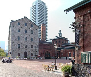
Distillery District This image was created with Hugin. / CC BY-SA 3.0

The Distillery District is a commercial and residential district in Toronto, Ontario, Canada, east of downtown, which contains numerous cafés, restaurants, and shops housed within heritage buildings of the former Gooderham and Worts Distillery. The 13 acres (5.3 ha) district comprises more than forty heritage buildings and ten streets, and is the largest collection of Victorian-era industrial architecture in North America.

Wikipedia: Distillery District (EN)

384 meters / 5 minutes

Sight 2: Enoch Turner Schoolhouse Museum

Show sight on map

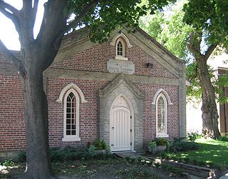
Enoch Turner Schoolhouse is a historic site and museum in Toronto, Ontario, Canada. It is a former school owned by the Ontario Heritage Trust. The school was built in 1848 when it was known as the Ward School. The building is located at 106 Trinity Street between King Street East and Eastern Avenue. It is the oldest school standing in the city.

Wikipedia: Enoch Turner School (EN), Website

52 meters / 1 minutes

Sight 3: Little Trinity Anglican Church

Show sight on map

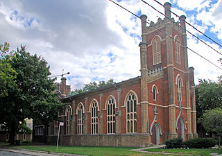
Little Trinity Anglican Church is a parish church of the Anglican Church of Canada. It is located at 425 King Street East in the Corktown neighbourhood, just east of downtown Toronto, Ontario, Canada. An Ontario Heritage Trust plaque at the site notes that the 1844 church is the oldest surviving church in the city.

Wikipedia: Little Trinity Anglican Church (EN)

409 meters / 5 minutes

Sight 4: Former Cherry Street Hotel

Show sight on map
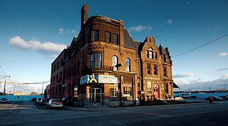
Former Cherry Street HotelRick Harris from Whiby, Ontario, Canada / CC BY-SA 2.0

The Cherry Street Hotel is an 1859 heritage building in Toronto, Ontario, Canada. It is located on the southeast corner of Front Street and Cherry Street, in the West Don Lands neighbourhood. The structure was originally the Palace Street School, which closed in 1887. The building was converted into a hotel, and later became an industrial building housing small industry. In the 1960s, the Canary Restaurant opened. The building became a type of incubator, renting small spaces for artists and small businesses. The restaurant closed after the area around the building was demolished for the new West Don Lands community. The building has been integrated into the new community and its facade retained and restored. Its next use has not been announced.

Wikipedia: Cherry Street Hotel (EN)

461 meters / 6 minutes

Sight 5: Corktown Common

Show sight on map

Corktown Common is a park in the south eastern portion of the West Don Lands neighbourhood in Toronto, Ontario, Canada which opened in 2013. It borders the Don River to the east. It was built on remediated industrial lands to be the centrepiece of a new emerging neighbourhood in downtown Toronto. It also provides a barrier to flooding from the Don River.

Wikipedia: Corktown Common (EN), Website

771 meters / 9 minutes

Sight 6: Dominion Hotel

Show sight on map
Dominion Hotel

The Dominion Hotel is a restaurant and former hotel in Toronto, Ontario, Canada. Constructed in the late nineteenth century in the Corktown neighbourhood, it is a heritage hotel structure that has not been torn down and replaced with a modern structure. The structure is a designated heritage property.

Wikipedia: Dominion Hotel, Toronto (EN)

473 meters / 6 minutes

Sight 7: St. Paul's Basilica

Show sight on map

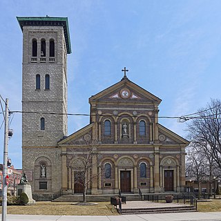
St. Paul's Basilica is the oldest Roman Catholic congregation in Toronto, Ontario, Canada. It is located at 83 Power Street in the Corktown neighbourhood, just east of downtown, near the intersection of Queen and Parliament streets.

Wikipedia: St. Paul's Basilica (Toronto) (EN)

1298 meters / 16 minutes

Sight 8: Metropolitan United Church

Show sight on map

Metropolitan United Church is a historic Neo-Gothic style church in downtown Toronto, Ontario, Canada. It is one of the largest and most prominent churches of the United Church of Canada. It is located at 56 Queen Street East, between Bond and Church streets, in Toronto's Garden District.

Wikipedia: Metropolitan United Church (EN), Website

517 meters / 6 minutes

Sight 9: Ontario Heritage Centre

Show sight on map

The Ontario Heritage Trust is a non-profit agency of the Ontario Ministry of Tourism and Culture. It is responsible for protecting, preserving and promoting the built, natural and cultural heritage of Canada's most populous province, Ontario.

Wikipedia: Ontario Heritage Trust (EN)

238 meters / 3 minutes

Sight 10: Morgan Meighen & Associates

Show sight on map

The Toronto Street Post Office, also known as Toronto's Seventh Post Office, is a heritage building in Toronto, Ontario, Canada. It was completed in 1853 and is located at 10 Toronto Street in downtown Toronto. The building was designed by Frederick William Cumberland and Thomas Ridout in the Greek Revival style.

Wikipedia: Toronto Street Post Office (EN)

147 meters / 2 minutes

Sight 11: The Omni King Edward Hotel

Show sight on map

The Omni King Edward Hotel, also known as the "King Eddy", is a historic luxury hotel in Downtown Toronto, Ontario, Canada. The hotel is located at 37 King Street East, and it occupies the entire block bounded by King Street on the north, Victoria Street on the east, Colborne Street on the south and Leader Lane on the west.

Wikipedia: King Edward Hotel (Toronto) (EN), Website

245 meters / 3 minutes

Sight 12: Cathedral Church of St. James

Show sight on map

The Cathedral Church of St. James is an Anglican cathedral in Downtown Toronto, Ontario, Canada. It is the location of the oldest congregation in the city, with the parish being established in 1797. The church, with construction beginning in 1850 and opening for services on June 19, 1853, was one of the largest buildings in the city at that time. It was designed by Frederick William Cumberland and is a prime example of Gothic Revival architecture.

Wikipedia: Cathedral Church of St. James (Toronto) (EN)

265 meters / 3 minutes

Sight 13: Daniel Brooke Building

Show sight on map

Daniel Brooke Building is a 19th-century Georgian building in Toronto, Ontario, Canada located on the northeast corner of Jarvis Street and King Street. The building is one of the last remaining buildings of the old Town of York. Built in 1833 for owners Daniel Brooke and John Murchison, it was rebuilt before 1849 and damaged by the Toronto Fire of 1849.

Wikipedia: Daniel Brooke Building (EN)

80 meters / 1 minutes

Sight 14: St. Lawrence Hall

Show sight on map

St. Lawrence Hall is a meeting hall in Toronto, Ontario, Canada, located at the corner of King Street East and Jarvis Street. It was created to be Toronto's public meeting hall home to public gatherings, concerts, and exhibitions. Its main feature was a thousand-seat amphitheatre. For decades the hall was the centre of Toronto's social life before larger venues took over much of this business. Today the hall continues as a venue for events including weddings, conferences, and art shows.

Wikipedia: St. Lawrence Hall (EN)

197 meters / 2 minutes

Sight 15: The Market Gallery

Show sight on map

The St. Lawrence Market South building is a major public market building in Toronto, Ontario, Canada. It is located on the southwest corner of Front and Lower Jarvis Streets. Along with the St. Lawrence Market North and St. Lawrence Hall, it comprises the St. Lawrence Market complex. The current building was opened in 1902, incorporating the 1845 Toronto City Hall building into the structure. The building was restored during the 1970s.

Wikipedia: St. Lawrence Market South (EN), Website

55 meters / 1 minutes

Sight 16: St. Lawrence Market South

Show sight on map

St. Lawrence Market is a major public market in Toronto, Ontario, Canada. It is located along Front Street East and Jarvis Street in the St. Lawrence neighbourhood of downtown Toronto. The public market is made up of two sites adjacent to one another west of Jarvis Street, St. Lawrence Market North, and St. Lawrence Market South. St. Lawrence Market South is situated south of Front Street East, and is bounded by The Esplanade to the south. St. Lawrence Market North is situated north of Front Street East, and is bounded by St. Lawrence Hall to the north.

Wikipedia: St. Lawrence Market (EN), Url

305 meters / 4 minutes

Sight 17: Gooderham Building

Show sight on mapJoin Free Tour*

The Gooderham Building, also known as the Flatiron Building, is an historic office building at 49 Wellington Street East in Toronto, Ontario, Canada. It is located on the eastern edge of the city's Financial District in the St. Lawrence neighbourhood, wedged between Front Street and Wellington Street in Downtown Toronto, where they join up to form a triangular intersection. Completed in 1892, the red-brick edifice was an early example of a prominent flatiron building.

Wikipedia: Gooderham Building (EN)

21 meters / 0 minutes

Sight 18: The Flatiron Mural

Show sight on map

Derek Michael Besant is a Canadian artist living in Calgary, Alberta who, since the 1980s, has created prints, watercolours and large-scale art, shown in exhibitions and as public art projects in Canada and abroad. Since the mid-1990s, he has developed working with the new technology available in photographic imaging to create experimental prints and print installations.

Wikipedia: Derek Michael Besant (EN)

198 meters / 2 minutes

Sight 19: St. Lawrence Centre for the Arts

Show sight on map

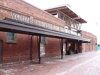
The St. Lawrence Centre for the Arts is a performing arts theatre complex located in downtown Toronto, Ontario, Canada. Situated on Front Street one block east of Yonge Street, it was the City of Toronto's official centennial project, commemorating the 1967 Canadian Centennial. It houses two auditoriums, the 868-seat Bluma Appel Theatre and the 499-seat Jane Mallett Theatre.

Wikipedia: St. Lawrence Centre for the Arts (EN)

117 meters / 1 minutes

Sight 20: Meridian Hall

Show sight on map

Meridian Hall is a performing arts venue in Toronto, Ontario, and it is the country's largest soft-seat theatre. The facility was constructed for the City of Toronto municipal government and is currently managed by TO Live, an arms-length agency and registered charity created by the city. Located at 1 Front Street East, the venue opened as the O'Keefe Centre on October 1, 1960. From 1996 to 2007, the building was known as the Hummingbird Centre for the Performing Arts. From 2007 to 2019, it was known as the Sony Centre for the Performing Arts. On September 15, 2019, it was re-branded as Meridian Hall.

Wikipedia: Meridian Hall (Toronto, Ontario) (EN), Website

295 meters / 4 minutes

Sight 21: Hockey Hall of Fame

Show sight on mapGet Ticket*

The Hockey Hall of Fame is a museum and hall of fame located in Toronto, Ontario, Canada. Dedicated to the history of ice hockey, it holds exhibits about players, teams, National Hockey League (NHL) records, memorabilia and NHL trophies, including the Stanley Cup. Founded in Kingston, Ontario, the Hockey Hall of Fame was established in 1943 under the leadership of James T. Sutherland. The first class of honoured members was inducted in 1945, before the Hall of Fame had a permanent location. It moved to Toronto in 1958 after the NHL withdrew its support for the International Hockey Hall of Fame in Kingston, Ontario, due to funding issues. Its first permanent building opened at Exhibition Place in 1961. The hall was relocated in 1993, and is now in Downtown Toronto, inside Brookfield Place, and a historic Bank of Montreal building. The Hockey Hall of Fame has hosted International Ice Hockey Federation (IIHF) exhibits and the IIHF Hall of Fame since 1998.

Wikipedia: Hockey Hall of Fame (EN), Website

326 meters / 4 minutes

Sight 22: Design Exchange

Show sight on map

The Design Exchange (DX) is a Canadian event venue. It is located in Toronto's financial district in the historical Toronto Stock Exchange building, that was incorporated into a skyscraper in 1991, the Toronto-Dominion Centre. The organization operated a design museum, but this museum was closed in 2019. Since 2017, it hosts a biennial design festival, the Expo for Design, Innovation, & Technology (EDIT).

Wikipedia: Design Exchange (EN)

428 meters / 5 minutes

Sight 23: Monument to Multiculturalism

Show sight on map
Monument to Multiculturalismpaul (dex) from Toronto / CC BY 2.0

The term multiculturalism has a range of meanings within the contexts of sociology, political philosophy, and colloquial use. In sociology and in everyday usage, it is a synonym for ethnic pluralism, with the two terms often used interchangeably, and for cultural pluralism in which various ethnic and cultural groups exist in a single society. It can describe a mixed ethnic community area where multiple cultural traditions exist or a single country within which they do. Groups associated with an indigenous, aboriginal or autochthonous ethnic group and settler-descended ethnic groups are often the focus.

Wikipedia: Multiculturalism (EN)

542 meters / 7 minutes

Sight 24: St. Andrew's Church

Show sight on map

St. Andrew's Church is a historic Presbyterian church located at the corner of King Street West and Simcoe Street in the city's downtown core of Toronto, Ontario, Canada. It was designed by William George Storm in the Romanesque Revival style and completed in 1876.

Wikipedia: St. Andrew's Church (Toronto) (EN)

173 meters / 2 minutes

Sight 25: Roy Thomson Hall

Show sight on map

Roy Thomson Hall is a concert hall in Toronto, Ontario, Canada. Located downtown in the city's entertainment district, it is home to the Toronto Symphony Orchestra, the Toronto Mendelssohn Choir, and the Toronto Defiant. Opened in 1982, its circular architectural design exhibits a sloping and curvilinear glass exterior. It was designed by Canadian architects Arthur Erickson and Mathers and Haldenby. Itzhak Perlman acted as a special advisor to the architects on accessibility needs for disabled performers and guests.

Wikipedia: Roy Thomson Hall (EN), Website

211 meters / 3 minutes

Sight 26: Royal Alexandra Theatre

Show sight on map

The Royal Alexandra Theatre, commonly known as the Royal Alex, is an historic performing arts theatre in Toronto, Ontario. The theatre is located at 260 King Street West, in the downtown Toronto Entertainment District. Owned and operated by Mirvish Productions, the theatre has approximately 1,244 seats across three levels. Built in 1907, the Royal Alexandra Theatre is the oldest continuously operating legitimate theatre in North America.

Wikipedia: Royal Alexandra Theatre (EN), Website

231 meters / 3 minutes

Sight 27: Princess of Wales Theatre

Show sight on map

The Princess of Wales Theatre is a 2,000-seat live theatre in Toronto, Ontario, Canada. It is located on King Street West, in Toronto's downtown Entertainment District. The theatre's name has a triple meaning: it honours Diana, Princess of Wales, with whose consent the theatre was named; it links the building to its sister theatre, the Royal Alexandra, one block to the east, also named – with Royal assent – for a former Princess of Wales; and it recalls the Princess Theatre, Toronto's first "first-class legitimate" playhouse, that stood three blocks to the east until 1931.

Wikipedia: Princess of Wales Theatre (EN), Website

681 meters / 8 minutes

Sight 28: CN Tower

Show sight on map

The CN Tower is a 553.3 m-high (1,815.3 ft) concrete communications and observation tower in Toronto, Ontario, Canada. Completed in 1976, it is located in downtown Toronto, built on the former Railway Lands. Its name "CN" referred to Canadian National, the railway company that built the tower. Following the railway's decision to divest non-core freight railway assets prior to the company's privatization in 1995, it transferred the tower to the Canada Lands Company, a federal Crown corporation responsible for the government's real estate portfolio.

Wikipedia: CN Tower (EN), Website

115 meters / 1 minutes

Sight 29: Ripley's Aquarium of Canada

Show sight on map

Ripley's Aquarium of Canada is a public aquarium in Toronto, Ontario, Canada. The aquarium is one of three aquariums owned-and-operated by Ripley Entertainment. It is located in downtown Toronto, just southeast of the CN Tower. The aquarium has 5.7 million litres of marine and freshwater habitats from across the world. The exhibits hold more than 20,000 exotic sea and freshwater specimens from more than 450 species.

Wikipedia: Ripley's Aquarium of Canada (EN), Website

295 meters / 4 minutes

Sight 30: Roundhouse Park

Show sight on map

Roundhouse Park is a 17 acre park in the downtown core of Toronto, Ontario, Canada. It is in the former Railway Lands. It features the John Street Roundhouse, a preserved locomotive roundhouse which is home to the Toronto Railway Museum, Steam Whistle Brewing, and the restaurant and entertainment complex The Rec Room. The park is also home to a collection of trains, the former Canadian Pacific Railway Don Station, and the Roundhouse Park Miniature Railway. The park is bounded by Bremner Boulevard, Lower Simcoe Street, Lake Shore Boulevard West/Gardiner Expressway and Rees Street.

Wikipedia: Roundhouse Park (EN)

Share

Spread the word! Share this page with your friends and family.

Disclaimer Please be aware of your surroundings and do not enter private property. We are not liable for any damages that occur during the tours.

GPX-Download For navigation apps and GPS devices you can download the tour as a GPX file.