Self-guided Sightseeing Tour #1 in Salvador, Brazil
Legend
Guided Free Walking Tours
Book free guided walking tours in Salvador.
Guided Sightseeing Tours
Book guided sightseeing tours and activities in Salvador.
Tour Facts
3.4 km
124 m
Experience Salvador in Brazil in a whole new way with our free self-guided sightseeing tour. This site not only offers you practical information and insider tips, but also a rich variety of activities and sights you shouldn't miss. Whether you love art and culture, want to explore historical sites or simply want to experience the vibrant atmosphere of a lively city - you'll find everything you need for your personal adventure here.
Individual Sights in SalvadorSight 1: Monumento Cruz do Pascoal

The Cruz do Pascoal, or Public Oratory of the Cruz do Pascoal, is a public monument in Salvador, capital of the Brazilian state of Bahia. It was listed by the National Historical and Artistic Heritage Institute (IPHAN) in 1938, through process No. 122.
Sight 2: Church of the Third Order of Mount Carmel

The Church of the Third Order of Mount Carmel is an 18th-century Roman Catholic church in Salvador, Bahia, Brazil. It is located adjacent to the Church and Convent of Our Lady of Mount Carmel. Work on the church began in 1644. It was destroyed by fire in 1788 and subsequently rebuilt. The church is a large complex consisting of a nave, chancel, choir, corridors, tribunes, meeting rooms, and a sacristy. The interior was richly decorated in the 18th century; the painting of the ceiling of the nave is the first major work by José Teófilo de Jesus. The Church of the Third Order of Mount Carmel was listed as a historic structure by National Institute of Historic and Artistic Heritage (IPHAN) in 1938 and is part of the Historic Center of Salvador UNESCO World Heritage Site.
Sight 3: Igreja do Santíssimo Sacramento do Passo

The Church of the Blessed Sacrament at Rua do Passo is an 18th-century Roman Catholic church in Salvador, Bahia, Brazil. It is dedicated to the Blessed Sacrament. The Church of the Blessed Sacrament at Rua do Passo was listed as a historic structure by National Institute of Historic and Artistic Heritage (IPHAN) in 1938 and is part of the Historic Center of Salvador UNESCO World Heritage Site.
Wikipedia: Church of the Blessed Sacrament at Rua do Passo (EN)
Sight 4: Igreja do Rosário dos Pretos

The Church of the Third Order of Our Lady of the Rosary of the Black People is an 18th-century Roman Catholic church in Salvador, Bahia, Brazil. The construction of the church took almost 100 years. It is dedicated to Our Lady of the Rosary and belongs to the Archdiocese of São Salvador da Bahia. The church was listed as a historic structure by National Institute of Historic and Artistic Heritage (IPHAN) in 1938 and is part of the Historic Center of Salvador UNESCO World Heritage Site.
Wikipedia: Church of Nossa Senhora do Rosário dos Pretos, Salvador (EN)
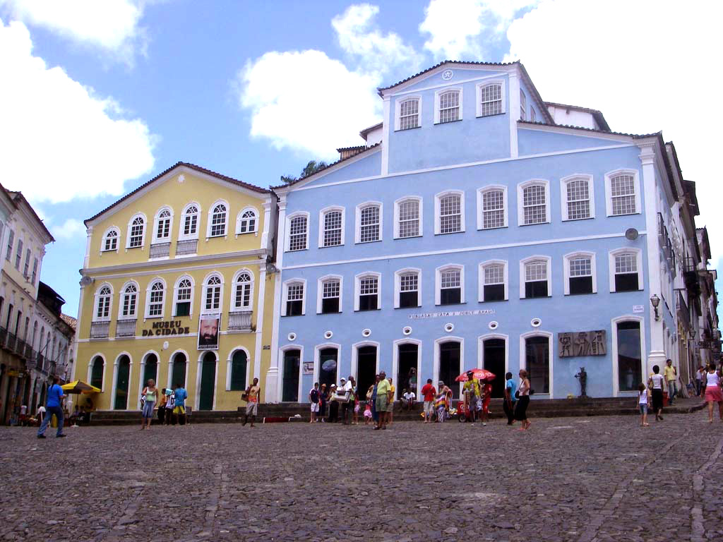
Sight 5: Museu da Cidade

The City Museum is a museum located in the Largo do Pelourinho region of Salvador, Bahia state. The Museum was inaugurated on July 5, 1973 and tells the history of the city. The museum's enormous variety of pieces ranges from ancient to modern, from sacred to profane and is responsible for demonstrating elements responsible for the artistic, religious and cultural diversity of Salvador.
Sight 6: Museu Abelardo Rodrigues

The Abelardo Rodrigues Museum is a Brazilian museum that occupies the Solar Ferrão, in Pelourinho, Salvador. The body is linked to the Institute of Artistic and Cultural Heritage of Bahia (IPAC) and its collection is focused on sacred art produced in Brazil.
Sight 7: Solar Ferrão

Solar Ferrão is a building located in Pelourinho, Historic Center of Salvador, capital of the Brazilian State of Bahia, and which is part of the national heritage listed by IPHAN. The building houses the Abelardo Rodrigues Museum of sacred art.
Sight 8: Fundação Casa de Jorge Amado
The Casa de Jorge Amado Foundation is a Brazilian non-governmental and non-profit organization headquartered in the mansion that faces Largo do Pelourinho, in Salvador, Bahia. It is a cultural institution with various activities and a research center, with documentation about Jorge Amado himself, Zélia Gattai and Bahian literature, open to visitation and highlighting courses, seminars, workshops, conference cycles, lectures, book and record launches, exhibitions, focusing on literary, artistic and human sciences themes.
Sight 9: Largo do Pelourinho

Largo do Pelourinho, officially Praça José de Alencar, is a street located in the neighborhood of Pelourinho, in the heart of the oldest part of the city of Salvador, Bahia, Brazil. Right next to the old Portas do Carmo, near the Terreiro de Jesus and one of the most famous sets of baroque churches in the Americas, formed by the churches of the Third Order of Saint Francis, all in gilded carving; of San Francisco; the Rosary of the Blacks; do Passo and the imposing Cathedral-basilica, formerly the Church of the College of Priests, where the poet Gregório de Matos studied and where Father Antônio Vieira preached.
Sight 10: Igreja São Pedro dos Clérigos

The Church of Saint Peter of the Clergymen is an 18th-century Roman Catholic church in Salvador, Bahia, Brazil. It was constructed by the Brotherhood of Saint Peter in approximately 1709 and was renovated in the 18th and 19th centuries. The church was listed as a historic structure by National Institute of Historic and Artistic Heritage (IPHAN) in 1938 and is part of the Historic Center of Salvador UNESCO World Heritage Site.
Sight 11: Museu Afro-Brasileiro

The Afro-Brazilian Museum in Salvador, Bahia, Brazil, was inaugurated on 7 January 1982 by the then Director of the Center for Afro-Oriental Studies (CEAO), Dr. Yeda Pessoa de Castro, through an agreement between the Ministries of Foreign Affairs and Education and Culture of Brazil, the government of Bahia, the city of Salvador and the Federal University of Bahia.
Sight 12: Escola Olodum
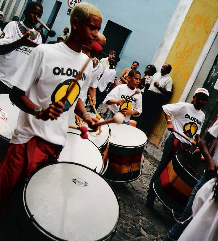
Olodum is a bloco-afro from Salvador's carnival, in Bahia, Brazil. It was founded by the percussionist Neguinho do Samba.
Sight 13: Terreiro de Jesus

The Terreiro de Jesus is a plaza located in the Historic Center of Salvador de Bahia in Brazil. The square is located in the oldest part of the city and abuts the Praça da Sé. The Cathedral Basilica of Salvador, formerly the school and church of the Jesuits, is the most prominent structure in the Terreiro de Jesus, and occupies the west of the square. The plaza takes its names from the society. It was renovated in the mid-20th century by the landscape architect Roberto Burle Marx. It is officially known as the Praça 15 de Novembro, and forms a central cultural and historical center of the city.
Sight 14: Praça da Sé

Praça da Sé is a public place in the Historic Center of Salvador, capital of the Brazilian state of Bahia. It emerged in the 1930s due to the demolition of the old Cathedral of Bahia, which gave rise to the name of the square, and some other colonial buildings. In the 1950s, it functioned as a bus terminal until the Lapa Terminal was built.
Sight 15: Praça Cairu

Maria Felipa Square, formerly known as Visconde de Cairu Square or Cairu Square, is a square located in Comércio, in the Lower City of Salvador, in the state of Bahia. It is home to the Mercado Modelo, the Monument to the City of Salvador and the lower station of the Lacerda Elevator, as well as the Bahia Nautical Terminal, bordering the Bay of All Saints and the Fort of São Marcelo in the background.
Sight 16: Casarão dos Azulejos Azuis

The Sobrado Azulejado, also known as the Sobrado de Azulejos, is a late 19th-century commercial building in Salvador, Bahia, Brazil. It is located in the Comércio district on Praça Cayru, a public square, and close to the Mercado Modelo public market. The house is entirely glazed in azulejo, a tin-glazed ceramic tile; all of the tiles of the sobrado were manufactured in Portugal. The structure was listed as a national heritage site by the National Institute of Historic and Artistic Heritage (IPHAN) in 1969. Udo Knoff, a ceramics researcher, called the building "the most azulejo-tiled building" in Bahia.
Sight 17: Elevador Lacerda

The Lacerda Elevator (Elevador Lacerda) is a public urban elevator located in Salvador, Brazil, connecting the lower city (Cidade Baixa) to the upper city (Cidade Alta). The 72 metres (236 ft) elevator was built between 1869 and 1873; it was named after Antônio de Lacerda, director of the Commercial Association of Bahia. It was a hydraulic elevator at first; later operating by electricity since 1906. The elevator towers were renovated in 1930, in an Art Deco styling. The Lacerda Elevator has two towers, one that pierces the stone slope of the Ladeira da Montanha, and the other, more visible, goes to the Cidade Baixa level. The elevator has four lifts, carrying 27 passengers each on a 30-second ride costing 0.15 reais. In 2019 it transported more than 33,000 passengers per day.
Sight 18: Mario Cravo

The Monument to the City of Salvador, also known as Fonte da Rampa do Mercado, is a sculpture by Bahian artist Mário Cravo, installed in the Comércio neighborhood, in Salvador, on January 13, 1970. It is a listed monument, at the state level. It is located in Praça Visconde de Cairu, close to other iconic structures of the city, also listed, such as the Lacerda Elevator and the Mercado Modelo. It is also close to the headquarters of the 2nd Naval District and the Nautical Tourist Terminal of Bahia.
Sight 19: Historic Centre of Salvador de Bahia

The Historic Center (US) or Centre (UK) of Salvador de Bahia in Brazil, also known as the Pelourinho or Pelo, is a historic neighborhood in western Salvador, Bahia. It was the city's center during the Portuguese colonial period and was named for the whipping post in its central plaza where enslaved people from Africa were publicly beaten as punishment for alleged infractions. The Historic Center is extremely rich in historical monuments dating from the 17th through the 19th centuries.
Sight 20: Praça Castro Alves

Castro Alves Square is a street located in the city of Salvador, capital of the Brazilian state of Bahia, located in the central part of the old urban center, in Cidade Alta.
Share
How likely are you to recommend us?
Disclaimer Please be aware of your surroundings and do not enter private property. We are not liable for any damages that occur during the tours.
GPX-Download For navigation apps and GPS devices you can download the tour as a GPX file.