46 Sights in Salvador, Brazil (with Map and Images)
Legend
Premium Sights
Book tickets, guided tours and activities in Salvador.
Guided Free Walking Tours
Book free guided walking tours in Salvador.
Welcome to your journey through the most beautiful sights in Salvador, Brazil! Whether you want to discover the city's historical treasures or experience its modern highlights, you'll find everything your heart desires here. Be inspired by our selection and plan your unforgettable adventure in Salvador. Dive into the diversity of this fascinating city and discover everything it has to offer.
Sightseeing Tours in Salvador1. Historic Centre of Salvador de Bahia

The Historic Center (US) or Centre (UK) of Salvador de Bahia in Brazil, also known as the Pelourinho or Pelo, is a historic neighborhood in western Salvador, Bahia. It was the city's center during the Portuguese colonial period and was named for the whipping post in its central plaza where enslaved people from Africa were publicly beaten as punishment for alleged infractions. The Historic Center is extremely rich in historical monuments dating from the 17th through the 19th centuries.
2. Igreja Senhor do Bonfim

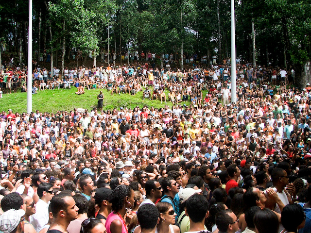
The Church of Our Lord of Bonfim is the most famous of the Catholic churches of Salvador, in the State of Bahia, Brazil. It was built in the 18th century on the only line of hills in the Itapagipe Peninsula, in the lower town of Salvador. The church is the subject of intense religious devotion by the people of Salvador and is the site of a famous celebration held every year in January, the Festa do Senhor do Bonfim. The church is the cathedral of the Roman Catholic Diocese of Bonfim. The church is noted for the Festa do Bonfim, held annually the second Thursday after Three Kings Day. The festival combines elements of both Catholicism and Candomblé. It was listed as a historic structure by the National Historic and Artistic Heritage Institute in 1938.
Wikipedia: Church of Nosso Senhor do Bonfim, Salvador (EN), Website
3. Teatro Castro Alves

The Castro Alves Theater (TCA) is a Brazilian theater. It is the largest and most important artistic center in Salvador, capital of the state of Bahia, and is located in Largo do Campo Grande. In 2013, it was listed by the National Institute of Historical and Artistic Heritage (IPHAN).
4. Lagoa do Abaeté

The Abaeté Lagoon is a lagoon located in the Parque Metropolitano Lagoas e Dunas do Abaeté environmental protection area, in the Itapuã neighborhood of Salvador, Bahia, Brazil. Located more than 10 kilometers from the center of the state capital, the main access road begins at the Ibiama slope, in Itapuã, and goes to the Mirante slope, which ends precisely at the Abaeté viewpoint, from where you can have a wide view of the park. It is ten kilometers north of Salvador and three kilometers south of Lauro de Freitas, at approximately 12° 59' S and 38° 30' W.
5. Parque da Cidade
The Joventino Silva City Park, popularly known as City Park, is a park in Salvador, Bahia. It is located in the Pituba neighborhood, close to the neighborhoods of Santa Cruz, Itaigara and Nordeste de Amaralina. It was created in 1973 and renovated in 2001 and again in 2014.
6. Fundação Casa de Jorge Amado
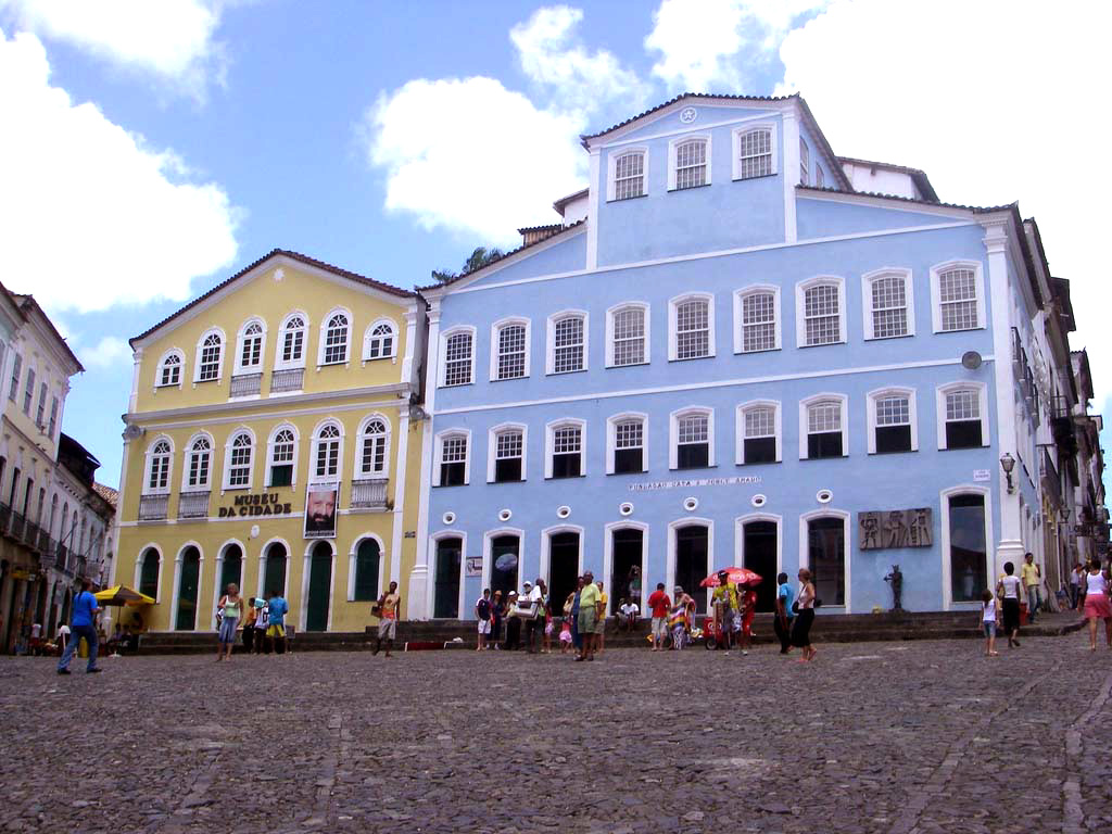
The Casa de Jorge Amado Foundation is a Brazilian non-governmental and non-profit organization headquartered in the mansion that faces Largo do Pelourinho, in Salvador, Bahia. It is a cultural institution with various activities and a research center, with documentation about Jorge Amado himself, Zélia Gattai and Bahian literature, open to visitation and highlighting courses, seminars, workshops, conference cycles, lectures, book and record launches, exhibitions, focusing on literary, artistic and human sciences themes.
7. Museu Abelardo Rodrigues

The Abelardo Rodrigues Museum is a Brazilian museum that occupies the Solar Ferrão, in Pelourinho, Salvador. The body is linked to the Institute of Artistic and Cultural Heritage of Bahia (IPAC) and its collection is focused on sacred art produced in Brazil.
8. Museu de Arte da Bahia

The Palácio da Vitória is a building located on Avenida Sete de Setembro, in the neighborhood of Vitória, in Salvador, capital municipality of the Brazilian state of Bahia. It has housed, since 1982, the Museum of Art of Bahia.
9. Museu Carlos Costa Pinto

The Carlos Costa Pinto Museum is located on Avenida Sete de Setembro, in Salvador, Bahia, Brazil. It is a foundation, a private cultural institution maintained through an agreement with the Government of the State of Bahia.
10. Largo do Pelourinho

Largo do Pelourinho, officially Praça José de Alencar, is a street located in the neighborhood of Pelourinho, in the heart of the oldest part of the city of Salvador, Bahia, Brazil. Right next to the old Portas do Carmo, near the Terreiro de Jesus and one of the most famous sets of baroque churches in the Americas, formed by the churches of the Third Order of Saint Francis, all in gilded carving; of San Francisco; the Rosary of the Blacks; do Passo and the imposing Cathedral-basilica, formerly the Church of the College of Priests, where the poet Gregório de Matos studied and where Father Antônio Vieira preached.
11. Lighthouse Itapuã

The Itapuã Lighthouse or Ponta de Itapuã Lighthouse is a lighthouse in Salvador, Bahia, Brazil. It is located on Itapuã beach, in the subdistrict of Itapuã, about 23 kilometers (14 mi) east-northeast of the Barra lighthouse.
12. Memorial Irmã Dulce

The Sister Dulce Memorial (MID) is a permanent exhibition on the life and work of the Bahian nun Sister Dulce, who has the function of keeping and disseminating her legacy. It was inaugurated in Salvador in 1993, a year after his death, and receives about twenty thousand visits annually. The memorial is located in a building attached to the Santo Antônio Convent, at the headquarters of the Sister Dulce Social Works (OSID), in the Roma neighborhood.
13. Church of the Third Order of Mount Carmel

The Church of the Third Order of Mount Carmel is an 18th-century Roman Catholic church in Salvador, Bahia, Brazil. It is located adjacent to the Church and Convent of Our Lady of Mount Carmel. Work on the church began in 1644. It was destroyed by fire in 1788 and subsequently rebuilt. The church is a large complex consisting of a nave, chancel, choir, corridors, tribunes, meeting rooms, and a sacristy. The interior was richly decorated in the 18th century; the painting of the ceiling of the nave is the first major work by José Teófilo de Jesus. The Church of the Third Order of Mount Carmel was listed as a historic structure by National Institute of Historic and Artistic Heritage (IPHAN) in 1938 and is part of the Historic Center of Salvador UNESCO World Heritage Site.
14. Solar Ferrão

Solar Ferrão is a building located in Pelourinho, Historic Center of Salvador, capital of the Brazilian State of Bahia, and which is part of the national heritage listed by IPHAN. The building houses the Abelardo Rodrigues Museum of sacred art.
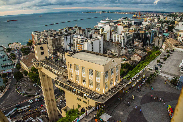
15. Elevador Lacerda

The Lacerda Elevator (Elevador Lacerda) is a public urban elevator located in Salvador, Brazil, connecting the lower city (Cidade Baixa) to the upper city (Cidade Alta). The 72 metres (236 ft) elevator was built between 1869 and 1873; it was named after Antônio de Lacerda, director of the Commercial Association of Bahia. It was a hydraulic elevator at first; later operating by electricity since 1906. The elevator towers were renovated in 1930, in an Art Deco styling. The Lacerda Elevator has two towers, one that pierces the stone slope of the Ladeira da Montanha, and the other, more visible, goes to the Cidade Baixa level. The elevator has four lifts, carrying 27 passengers each on a 30-second ride costing 0.15 reais. In 2019 it transported more than 33,000 passengers per day.
16. Terreiro de Jesus

The Terreiro de Jesus is a plaza located in the Historic Center of Salvador de Bahia in Brazil. The square is located in the oldest part of the city and abuts the Praça da Sé. The Cathedral Basilica of Salvador, formerly the school and church of the Jesuits, is the most prominent structure in the Terreiro de Jesus, and occupies the west of the square. The plaza takes its names from the society. It was renovated in the mid-20th century by the landscape architect Roberto Burle Marx. It is officially known as the Praça 15 de Novembro, and forms a central cultural and historical center of the city.
17. Igreja do Rosário dos Pretos

The Church of the Third Order of Our Lady of the Rosary of the Black People is an 18th-century Roman Catholic church in Salvador, Bahia, Brazil. The construction of the church took almost 100 years. It is dedicated to Our Lady of the Rosary and belongs to the Archdiocese of São Salvador da Bahia. The church was listed as a historic structure by National Institute of Historic and Artistic Heritage (IPHAN) in 1938 and is part of the Historic Center of Salvador UNESCO World Heritage Site.
Wikipedia: Church of Nossa Senhora do Rosário dos Pretos, Salvador (EN)
18. Igreja São Pedro dos Clérigos

The Church of Saint Peter of the Clergymen is an 18th-century Roman Catholic church in Salvador, Bahia, Brazil. It was constructed by the Brotherhood of Saint Peter in approximately 1709 and was renovated in the 18th and 19th centuries. The church was listed as a historic structure by National Institute of Historic and Artistic Heritage (IPHAN) in 1938 and is part of the Historic Center of Salvador UNESCO World Heritage Site.
19. Igreja do Santíssimo Sacramento do Passo

The Church of the Blessed Sacrament at Rua do Passo is an 18th-century Roman Catholic church in Salvador, Bahia, Brazil. It is dedicated to the Blessed Sacrament. The Church of the Blessed Sacrament at Rua do Passo was listed as a historic structure by National Institute of Historic and Artistic Heritage (IPHAN) in 1938 and is part of the Historic Center of Salvador UNESCO World Heritage Site.
Wikipedia: Church of the Blessed Sacrament at Rua do Passo (EN)
20. Praça da Sé

Praça da Sé is a public place in the Historic Center of Salvador, capital of the Brazilian state of Bahia. It emerged in the 1930s due to the demolition of the old Cathedral of Bahia, which gave rise to the name of the square, and some other colonial buildings. In the 1950s, it functioned as a bus terminal until the Lapa Terminal was built.
21. Jardim dos Namorados

Parque Jardim dos Namorados is one of the urban parks in the city of Salvador in Bahia, it was created in the late 1960s. At the end of the 1990s, the park was reopened and the new project includes an amphitheater, porticoes, murals and sculptures by Bahian artists, sports courts and gym equipment. Located in the Pituba neighborhood, close to Costa Azul Park, it was implemented in front of Jardim dos Namorados Beach. The park has 110,000 square meters with space for cultural events, children's recreation, contemplation and others. It has a boardwalk, bike path, jogging, skating and skateboarding tracks, coconut sales kiosks, parking and a station for renting bicycles from Bike Salvador. There are usually craft fairs on some weekends, especially in the summer.
22. Casarão dos Azulejos Azuis

The Sobrado Azulejado, also known as the Sobrado de Azulejos, is a late 19th-century commercial building in Salvador, Bahia, Brazil. It is located in the Comércio district on Praça Cayru, a public square, and close to the Mercado Modelo public market. The house is entirely glazed in azulejo, a tin-glazed ceramic tile; all of the tiles of the sobrado were manufactured in Portugal. The structure was listed as a national heritage site by the National Institute of Historic and Artistic Heritage (IPHAN) in 1969. Udo Knoff, a ceramics researcher, called the building "the most azulejo-tiled building" in Bahia.
23. Igreja do Boqueirão

The Church of the Third Order of the Blessed Virgin Mary of Our Lady of the Conception of the Mulatto Brothers is an 18th-century Roman Catholic church and former convent in Salvador, Bahia, Brazil. The church was constructed in a neighborhood formerly occupied by mixed-race and Afro-Brazilian artisans. The exterior of the church has an elaborate roccoco pediment and towers; the interior of the church has a Baroque-style ceiling painting in the nave and neoclassical side altars and chancel. The name of the church, boqueirão, refers to a large slope and trench constructed between the high city and low city of Salvador; it served as a defense of the city against foreign invasion. It was listed as a historic structure by the National Historic and Artistic Heritage Institute in 1951.
24. Ponta do Humaitá

Ponta de Humaitá is a Brazilian coastal landform located in the neighborhood of Monte Serrat, on the Itapagipe Peninsula, in Salvador, a municipality in the state of Bahia. Its name Humaitá comes from Tupi-Guarani and means "black stone".
25. Parque Costa Azul
Costa Azul Park was built in 1995 in the neighborhood of the same name in the city of Salvador. Located along the waterfront, on the banks of the Camarajipe River, the area that gave rise to the park was occupied by the ruins of the Costa Azul Club and was the target for approximately two decades of claims by the population for the revitalization of the place. Currently the park is an area focused on sports, leisure and culture.
26. Igreja de Nossa Senhora da Penha

The Church of Our Lady of Penha is an 18th-century Roman Catholic church in Salvador, Bahia, Brazil. The church is located in the Ribeira neighborhood and constructed in 1742 as an extension of the Summer Palace of the Archbishop of the Roman Catholic Archdiocese of São Salvador da Bahia. The church sits at the end of the Itapagipe Peninsula and faces the Bay of All Saints. The Church of Our Lady of Penha was listed as a historic structure by the National Historic and Artistic Heritage Institute in 1941.
27. Mercado do Rio Vermelho

The Rio Vermelho market, also known as Ceasinha do Rio Vermelho or simply Ceasinha, is located in the city of Salvador, State of Bahia, Brazil. Situated in the Rio Vermelho neighborhood, on the edge of Juracy Magalhães Avenue, is a purchasing center for Hortifruti products, fishmongers, butchers, florists, handicraft stores and food court.
28. A Casa do Rio Vermelho

Casa do Rio Vermelho or Casa de Jorge Amado is how the residence where the couple of writers Jorge Amado and Zélia Gattai lived, in the neighborhood of Rio Vermelho, Rua Alagoinhas, in Salvador, Bahia.
29. Museu da Cidade

The City Museum is a museum located in the Largo do Pelourinho region of Salvador, Bahia state. The Museum was inaugurated on July 5, 1973 and tells the history of the city. The museum's enormous variety of pieces ranges from ancient to modern, from sacred to profane and is responsible for demonstrating elements responsible for the artistic, religious and cultural diversity of Salvador.
30. Mario Cravo

The Monument to the City of Salvador, also known as Fonte da Rampa do Mercado, is a sculpture by Bahian artist Mário Cravo, installed in the Comércio neighborhood, in Salvador, on January 13, 1970. It is a listed monument, at the state level. It is located in Praça Visconde de Cairu, close to other iconic structures of the city, also listed, such as the Lacerda Elevator and the Mercado Modelo. It is also close to the headquarters of the 2nd Naval District and the Nautical Tourist Terminal of Bahia.
31. Monumento Cruz do Pascoal

The Cruz do Pascoal, or Public Oratory of the Cruz do Pascoal, is a public monument in Salvador, capital of the Brazilian state of Bahia. It was listed by the National Historical and Artistic Heritage Institute (IPHAN) in 1938, through process No. 122.
32. Igreja e Mosteiro de Nossa Senhora do Monte Serrat

The Church and Monastery of Our Lady of Monserrate is a 16th-century Roman Catholic church and monastery located in Salvador, Bahia, Brazil. The church and monastery are dedicated to Our Lady of Monserrate and belongs to the Roman Catholic Archdiocese of São Salvador da Bahia. It is located 200 metres (660 ft) from the Fort of Monserrate on a rock on the Itapagipe Peninsula. The date of construction of the structure is disputed; it dates to the 16th century, and has seen numerous alterations. The church was built either by the Spanish, or by the group that constructed the Garcia d'Ávila Tower House. Its design, along with that of numerous rural chapels of Bahia, is attributed to the Italian architect Baccio da Filicaia (1565-1628). The church interior was once lined entirely with 16th-century azulejos; now only a single strip of the tiles remain. The church was listed as a historic structure by the National Historic and Artistic Heritage Institute in 1958. It and the Chapel of Our Lady of the Ladder are the only remaining 16th-century chapels in Salvador.
Wikipedia: Church and Monastery of Our Lady of Monserrate (EN)
33. Museu Afro-Brasileiro

The Afro-Brazilian Museum in Salvador, Bahia, Brazil, was inaugurated on 7 January 1982 by the then Director of the Center for Afro-Oriental Studies (CEAO), Dr. Yeda Pessoa de Castro, through an agreement between the Ministries of Foreign Affairs and Education and Culture of Brazil, the government of Bahia, the city of Salvador and the Federal University of Bahia.
34. Igreja Nossa Senhora da Vitória

The Church of Our Lady of Victory is a 16th-century Roman Catholic church in Salvador, Bahia, Brazil. The church is dedicated to Our Lady of Victory and belongs to the Roman Catholic Archdiocese of São Salvador da Bahia. The church was built in approximately 1561 by the Portuguese, and is the second-oldest church in Brazil. The church was listed as a historic structure by the National Historic and Artistic Heritage Institute in 2005. It has a large collection of 18th-century Baroque images on the high altar. The façade of the church faced west to the Bay of All Saints until 1808. The church building was reoriented east in 1808, possibly in conjunction with the visit of John VI of Portugal to Bahia. The façade of the church was again greatly modified in 1910 to the present Neoclassical design; it is white with a Roman triangular pediment and elaborate decoration. A large-scale renovation of the church was carried out between 2014 and 2015. The work included improvements to the frescoes, secular paintings, the painting of the nave ceiling, the font, various sacred art objects, the high altar, and tombstones.
35. Praça Duque de Caxias
This is a list of squares in Salvador, the capital municipality of the Brazilian state of Bahia. In the past, notably until the installation of fountains for public water supply in the 1850s, Salvador's squares were spaces for Catholic religious festivities and processions, manifestations of local or imperial power such as punishments in the pillory, criminal executions on the gallows and proclamations of new laws, as well as the trade of food and services by the black population.
36. Teatro Vila velha

The Vila Velha Theater, also known simply as "Vila", is a performing arts center in Salvador, Bahia, Brazil. The theater was constructed in 1964 and is located on Avenida Sete, at the west of the 19th-century Neoclassical public area, the Passeio Público.
37. Igreja Nossa Senhora da Escada

The Chapel of Our Lady of the Ladder is a 16th-century Roman Catholic church located in Salvador, Bahia, Brazil. It was constructed as part of the Nossa Senhora de Escada sugar plantation by Lázaro Arévolo, likely in 1566; he donated the chapel to the Jesuits in the late 16th century. The chapel is part of the Roman Catholic Archdiocese of São Salvador da Bahia; it was listed as a historic structure by the National Institute of Historic and Artistic Heritage (IPHAN) in 1962. It and the Church and Monastery of Our Lady of Monserrate are the only remaining 16th-century chapels in Salvador.
38. Forte de Santa Maria

Forte de Santa Maria is a fort located in Salvador, Bahia in Brazil. It is also known as the Fortim de Santa Maria. It retains much of its original structure of the 17th century, including its broad, stone curtain walls. The fort is in the shape of a heptagon and is accessed via a narrow embankment. The fort was listed as a historic structure by the National Institute of Historic and Artistic Heritage (IPHAN) in 1938. It is closed to the public, is not maintained by federal or state institutions and is falling into a state of disrepair.
39. Igreja de São Lazaro

The Chapel of Saint Lazarus is an 18th-century Roman Catholic church located in Salvador, Bahia, Brazil. The chapel is dedicated to Saint Lazarus and Saint Roch. The chapel was established as a hermitage to treat people with leprosy; it was later used as a quarantine station for enslaved people arriving from Africa. Worship at the chapel is syncretic in character, with its two annual festivals combining Roman Catholic and Candomblé elements. The chapel is located on a hill high in the Federação neighborhood and consists of a single nave, altar, gallery, and sacristy. It is listed as a historic structure by the Instituto do Património Artístico e Cultural da Bahia.
40. Largo de Santana

Largo de Santana is a public place in the neighborhood of Rio Vermelho, located in the municipality of Salvador, capital of the state of Bahia. It is notorious for being one of the main bohemian regions of Salvador.
41. Monumento ao Cabloco

The Monument to the Two of July is a monument located in Largo do Campo Grande, in Salvador, capital municipality of the Brazilian state of Bahia. It represents and celebrates the participation of Brazilian natives in the Independence of Bahia. It is among the monuments of public interest in Salvador inventoried by the Gregório de Mattos Foundation (FGM), an organization of the City Hall of Salvador for cultural policy in the city.
42. Parque Zoobotânico Getúlio Vargas

The Getúlio Vargas Zoo and Botanical Park, or Salvador Zoo, is a zoo located in Salvador, the capital of the state of Bahia. Part of the total 700 thousand square meters of land is occupied by 250 thousand square meters of vegetation, the Mata do Zoo. The park is located in the Ondina neighborhood, more specifically, in Alto de Ondina, a hill that is also the address of the Ondina Palace, the official residence of the governors. It was created in 1958, according to state decree No. 17,481. There are 1500 existing animals belonging to 142 different species. The zoo is managed by the state government and is linked to the Department of the Environment of the State of Bahia (SEMA), as well as the Pituaçu Metropolitan Park and the Abaeté Metropolitan Park.
43. Museu de Arte Moderna da Bahia

The Museum of Modern Art of Bahia is a modern art museum located in Salvador, Bahia, Brazil. It is located within Solar do Unhão, a historical site dating to the 16th century, on the margin of the Bay of All Saints. The museum was founded in 1960 under the architect Lina Bo Bardi (1914-1992) and initially located in the foyer of the Castro Alves Theater; it moved to its present location in 1963. MAM-BA is one of twelve state museums linked to the Institute of Artistic and Cultural Heritage (IPAC), an authority of the Department of Culture of the State of Bahia.
44. Museu de Arte Contemporânea da Bahia
The Museum of Contemporary Art of Bahia is a public museum, managed by the Secretary of Culture of the State of Bahia and inaugurated on September 29, 2023. The museum is located on Rua da Graça in Salvador, in the Palacete do Comendador Bernardo Martins Catharino, where the Rodin Bahia Museum was once located.
Wikipedia: Museu de Arte Contemporânea da Bahia (PT), Instagram
45. Praça Cairu

Maria Felipa Square, formerly known as Visconde de Cairu Square or Cairu Square, is a square located in Comércio, in the Lower City of Salvador, in the state of Bahia. It is home to the Mercado Modelo, the Monument to the City of Salvador and the lower station of the Lacerda Elevator, as well as the Bahia Nautical Terminal, bordering the Bay of All Saints and the Fort of São Marcelo in the background.
46. Barra Lighthouse

The Barra Lighthouse, or Santo Antônio Lighthouse, is located at the former tip of the Padrão, currently Ponta de Santo Antônio, in Salvador, on the coast of the state of Bahia, Brazil. It was the first nautical signaling system to go into operation in the Americas. It was installed in the year 1698, initially in a quadrangular shape, with a bronze lantern glazed on top, fed by whale oil. It is the oldest lighthouse in the Americas still operating.
Share
How likely are you to recommend us?
Disclaimer Please be aware of your surroundings and do not enter private property. We are not liable for any damages that occur during the tours.