Self-guided Sightseeing Tour #6 in São Paulo, Brazil
Legend
Guided Free Walking Tours
Book free guided walking tours in São Paulo.
Guided Sightseeing Tours
Book guided sightseeing tours and activities in São Paulo.
Tour Facts
10.2 km
345 m
Experience São Paulo in Brazil in a whole new way with our free self-guided sightseeing tour. This site not only offers you practical information and insider tips, but also a rich variety of activities and sights you shouldn't miss. Whether you love art and culture, want to explore historical sites or simply want to experience the vibrant atmosphere of a lively city - you'll find everything you need for your personal adventure here.
Activities in São PauloIndividual Sights in São PauloSight 1: Paróquia Nossa Senhora da Consolação

Our Lady of Consolation Parish is a Roman Catholic church located in the Consolação neighborhood of São Paulo, Brazil. Its patron saint is Our Lady of Consolation and co-patron saint Saint John the Baptist.
Wikipedia: Paróquia Nossa Senhora da Consolação (São Paulo) (PT), Website
Sight 2: Edifício Itália

Edifício Itália is a 165 m (541 ft) tall 46-story skyscraper located in the República district, Central Zone of São Paulo, Brazil. Built from 1956 to 1965, it has a rooftop observation deck, open for tourists.
Sight 3: Secretaria da Educação do Estado de São Paulo
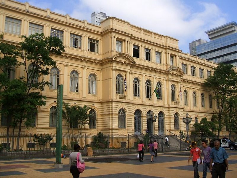
Casa Caetano de Campos, located in São Paulo, is considered one of the milestones in the process of renewing education in Brazil. Inaugurated on August 2, 1894 during a period of great investments in the education sector, the building was developed to host the First Normal School of the Capital, which became known as the Caetano de Campos Normal School in honor of the doctor and professor Antônio Caetano de Campos, director of the institution in the period in which the reform of São Paulo education took place. In addition, in 1934, it functioned as a support for the implementation of the University of São Paulo (USP) and housed for a time the Faculty of Philosophy, Sciences and Letters.
Sight 4: Praça da República

Praça da República is a park and public square in the República neighborhood of São Paulo, Brazil. The park covers several city blocks between Rua Pedro Américo, Rua Vinte e Quatro de Maio, Avenida Ipiranga, and Avenida São João in the historic center of the city. Praça da República had many names before 1889, including Largo dos Curros, Largo da Palha, Praça das Milícias, Largo Sete de Abril, and Praça 15 de Novembro.
Sight 5: Municipal Theatre of São Paulo

The Municipal Theater of São Paulo is a Brazilian theater located in the city of São Paulo, designed by architects Ramos de Azevedo, Claudio Rossi and Domiziano Rossi in the eclectic architectural style, inspired by the Paris Opera and inaugurated in 1911. It is one of the city's postcards, located in Praça Ramos de Azevedo, also considered one of the most important theaters in the country. Built to meet the desire of the São Paulo elite of the time, who wanted the city to be up to the great cultural centers.
Sight 6: Viaduto do Chá

Viaduto do Chá is a viaduct of São Paulo, Brazil. It was the first viaduct built in the city, and was instigated by Jules Martin, a French immigrant to the city. The 240-metre (790 ft) span crosses the Vale do Anhangabaú. Originally conceived in 1877, construction started in 1888 before being stopped one month later by a court case brought by local residents. Construction resumed in 1889, and the iron bridge was completed in 1892. The original viaduct was replaced in 1938 with a new concrete span. It often appears in TV interviews, as well as films and telenovelas set in São Paulo.
Sight 7: Igreja de Santo Antônio

The Santo Antônio Church is a Catholic temple located in the center of the city of São Paulo (Brazil), in Praça do Patriarca, near the Viaduto do Chá. The Church is a historical heritage of the state, in addition to also being considered the oldest remaining church in the city, founded in the last decades of the sixteenth century - as attested by the first documentary records of its existence, dated 1592. In the seventeenth century, it housed the Franciscan Order, and in the eighteenth century it was subordinated to the Brotherhood of Our Lady of the Rosary of the White Men. It has undergone several renovations and interventions over the last four centuries, especially in its façade, reopened in an eclectic style in 1919.
Sight 8: Edifício Sampaio Moreira

The Sampaio Moreira Building is located at 346, Líbero Badaró street, in the central region of São Paulo. With twelve floors and 50 metres (160 ft) high, the building was named Sampaio Moreira after its owner José de Sampaio Moreira (1866–1943), a merchant who the architect Christiano Stockler convinced in 1920 to make the building that would complete the Anhangabaú Park monument, which was finished four years later.
Sight 9: Edifício Martinelli
Get Ticket*
The Martinelli Building, with 28 floors, is the first skyscraper built in Brazil. Located in São Paulo, it is 105 meters tall.
Sight 10: Vale do Anhangabaú

Vale do Anhangabaú is a region in the city center of São Paulo, located between the viaducts do Chá and Santa Ifigênia. It is a public space commonly characterized as park, where events have traditionally been organized, such as public demonstrations, political rallies, presentations and popular shows. It is considered the point that separates the Old City Center from the New City Center.
Sight 11: Praça Ramos de Azevedo

The Ramos de Azevedo Square is located in the República district, in the center of the Brazilian city of São Paulo, and is famous for being home to the Municipal Theater. It was created in 1911, after the theater's inauguration, under the name Esplanada do Theatro. It was renamed in 1928, after the death of the architect Ramos de Azevedo.
Sight 12: Praça da Bandeira

Praça da Bandeira is a street located in the district of República, in the center of the municipality of São Paulo. It is an association between Largo da Bixiga and Largo do Piques. Until the 1960s, it was a public space with gardens. Today, almost the entire area is cut by avenues, viaducts and walkways, also having a municipal bus terminal that serves several regions of the city.
Sight 13: Convento São Francisco

The Church and Convent of Saint Francis was a religious institution installed in the town of São Paulo during colonial Brazil. In the 19th century, the convent was converted into a Law School. The Church of the Wounds of the Seraphic Father Saint Francis, built by the Secular Franciscan Order, is next to it.
Wikipedia: Church and Convent of Saint Francis (São Paulo) (EN)
Sight 14: Igreja São Francisco

The Church of St. Francis of Assisi is a temple of the Catholic Church located in Largo de São Francisco, in the historic center of São Paulo, Brazil.
Sight 15: Edifício Palacete Tereza Toledo Lara

The Tereza Toledo Lara Palace is a building listed by the historical heritage, located at 22 of Quintino Bocaiuva Street, with sides to the streets right and José Bonifácio in downtown São Paulo, Brazil. It was designed by Augusto Fried, German architect, who did several works in the city of São Paulo. The perimeter became known as "triangle", where the city begins. It is a common mistake to find references to heritage as a lara palace, another building located at 185 Álvares Penteado Street. The building has three floors: ground floor, two upper floors and the basement. Currently, on the ground floor we find several commercial establishments and on the upper floor a musical instrument store. The palace has an eclectic language, producing a composition of the meeting of Renaissance, Baroque, Mannerist and Neoclassical styles. Titled as "The Musical Corner of São Paulo", was once the matrix of Radio Record and home of numerous musical instrument stores, including Casa Bevilacqua and Editora Brothers Vitalle.
Sight 16: Edifício Triângulo

The Triangle Building is a commercial building located in the center of São Paulo, at Rua José Bonifácio, 24, at the intersection with Rua Quintino Bocaiúva, near Praça da Sé. Designed by Oscar Niemeyer and inaugurated in 1955, the building is one of the creations of the satellite office that the architect from Rio de Janeiro maintained in São Paulo in the 1950s, under the command of Carlos Lemos.
Sight 17: Sé Square
Praça da Sé is a public space in São Paulo, Brazil. Considered as the city's central point, it is the point from where the distance of all roads passing through São Paulo are counted. The square was the location of many historical events in São Paulo's history, most notably during the Diretas Já movement. The name originates from the episcopal see of the city, the São Paulo Cathedral.
Sight 18: Igreja Nossa Senhora da Boa Morte

The Church of Our Lady of the Good Death or Church of the Good Death of the Virgin Mary is a Roman Catholic temple located in the center of the city of São Paulo. It is located at Rua do Carmo, 202, in the vicinity of Praça da Sé. [1]
Wikipedia: Igreja Nossa Senhora da Boa Morte (São Paulo) (PT), Website
Sight 19: Capela do Menino Jesus e Santa Luzia

The Chapel of the Child Jesus and Saint Lucy is a Catholic religious temple located at Rua Tabatinguera, number 104, in the Sé neighborhood, in the center of the city of São Paulo, Brazil. In neo-Gothic style, typical of most buildings erected in Brazil at the beginning of the nineteenth century, the church inaugurated on December 13, 1901, the date of commemoration of the patron saint's feast, was built by the Italian architect Domenico Delpiano, one of the seven Salesian priests who arrived in Brazil in 1883, and has ornamental works by the Florentine painter Orestes Sercelli. considered a reference when it comes to artistic manifestations in churches.
Sight 20: Museu do Tribunal de Justiça SP

The Museum of the Court of Justice of São Paulo, inaugurated at the Palace of Justice on February 1, 1995, is a state institutional museum, linked to the Court of Justice of the State of São Paulo. In 2007 it began to be based in the Conde de Sarzedas Palace, established at the end of the nineteenth century, located at Rua Conde de Sarzedas, 100 in the city center, near the Sé subway. The museum holds temporary exhibitions and serves as a cultural space, in addition to preserving and transmitting material components related to the tradition and life of the São Paulo Judiciary, through its historical collection, so that new generations can have access to the history and objects related to the Judiciary.
Sight 21: Chapel of the Afflicted

The Chapel of Our Lady of the Afflicted, popularly known as Chapel of the Afflicted, is located on a small street in Liberdade, São Paulo between Galvão Bueno Street and Gloria, with access by Student Street and next to Liberdade Station, local Where one of the few alleys still existing in São Paulo, the alley of the afflicted. Inaugurated in 1775, when it was customary for burial to occur inside the churches, this open -air cemetery was reserved only for the burial of indigentes, slaves who did not belong to the Brotherhood of the Rosary and to those condemned to death in the force, known by supplicated.
Sight 22: Capela de Santa Cruz das Almas dos Enforcados

The Church of the Holy Cross of the Souls of the Hanged, or simply "Church of the Souls", is located in the neighborhood of Liberdade in the city of São Paulo, Brazil
Wikipedia: Igreja Santa Cruz das Almas dos Enforcados (PT), Website
Sight 23: Praça da Liberdade-Japão
Praça da Liberdade is a square in the city of São Paulo, located in the neighborhood of the same name.
Sight 24: Igreja São Gonçalo

The São Gonçalo Church is a Catholic temple located in Dr. João Mendes Square, in the center of the city of São Paulo, headquarters of the Parish of Our Lady of the Assumption and São Paulo and the Japanese-Brazilian Personal Parish São Gonçalo.
Sight 25: Praça Doutor João Mendes

Praça Doutor João Mendes, better known as Praça João Mendes, is a square located in the center of the municipality of São Paulo, whose name is a tribute to the jurist João Mendes de Almeida.
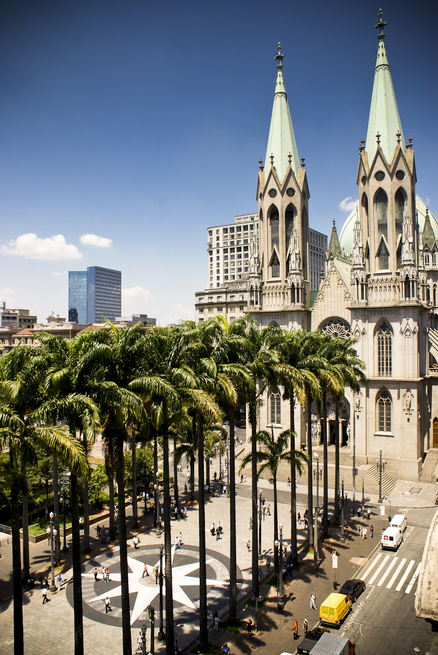
Sight 26: São Paulo Cathedral

The Metropolitan Cathedral of Our Lady Assumption and Saint Paul, also known as the See Cathedral, is the cathedral of the Roman Catholic Archdiocese of São Paulo, Brazil. Its current and seventh metropolitan archbishop is Dom Odilo Pedro Cardinal Scherer, appointed by Pope Benedict XVI on March 21, 2007, and installed on April 29 of the same year. The existing cathedral's construction, in a Gothic revival style, began in 1913 and ended four decades later. It was ready for its dedication on the 400th anniversary of the foundation of the then humble villa of São Paulo by Chief or Cacique Tibiriçá and the Jesuit priests Manuel da Nóbrega and José de Anchieta. Despite its Renaissance-style dome, the São Paulo Metropolitan Cathedral is considered by some to be the fourth largest neo-Gothic cathedral in the world.
Sight 27: Teatro Renault

Teatro Renault, also known as Teatro Paramount and Teatro Abril, is located on Brigadeiro Luís Antônio Avenue, in the Brazilian city of São Paulo. It opened in 1929, burned down in 1969 and reopened in 2001.
Sight 28: Teatro Oficina

Teat(r)o Oficina Uzyna Uzona or simply Teatro Oficina, is a theater company based in the neighborhood of Bixiga, in the Brazilian city of São Paulo. It was founded in 1958 at the Law School of the University of São Paulo by Amir Haddad, José Celso Martinez Correa, Carlos Queiroz Telles and Ron Daniels.
Sight 29: Casa de Dona Yayá

The Casa de Dona Yayá is a historic building in the Bixiga region, in the Bela Vista neighborhood, in São Paulo, and is currently managed by the Center for Cultural Preservation of the University of São Paulo. Built at the end of the nineteenth century, the house is a symbol of the eclectic architecture of the central region of São Paulo, with characteristics that symbolize different periods of the city's history in the last 100 years. Considered one of the last buildings in the farm belt that surrounded the city center in the twentieth century, the house today has characteristics attributed by four major renovations made by its five different owners over the years.
Sight 30: Centro de Preservação Cultural
The Center for Cultural Preservation (CPC) of the University of São Paulo is a center for the elaboration of reflections and actions related to the collection, conservation, research, experimentation and communication of testimonies of the cultural heritage of the Dean of Culture and University Extension of USP.
Wikipedia: Centro de Preservação Cultural da Universidade de São Paulo (PT), Facebook, Website
Sight 31: Teatro Brasileiro de Comédia

The Teatro Brasileiro de Comédia is located in the Bela Vista neighborhood, in the central zone of the Brazilian city of São Paulo. It was founded in 1948 by businessman Franco Zampari, with the financial support of part of São Paulo's elite.
Sight 32: Museu Judaico de São Paulo

The Jewish Museum of São Paulo is a Jewish museum in São Paulo, Brazil. It holds exhibits on Jewish life in Brazil and a collection of over 2,000 items brought over by immigrants to Brazil.
Sight 33: Teatro Cultura Artística

Since 1919, Sociedade de Cultura Artística nurtured the dream of having its own theatre in São Paulo, Brazil.
Sight 34: Praça Franklin Roosevelt

Praça Roosevelt is a public square in São Paulo, Brazil. Construction of the square began in 1968 and was completed in 1970. After decades of decline, the square was renovated in 2011–12. A second renovation to expand the skate park on Praça Roosevelt was completed in November 2014.
Share
How likely are you to recommend us?
Disclaimer Please be aware of your surroundings and do not enter private property. We are not liable for any damages that occur during the tours.
GPX-Download For navigation apps and GPS devices you can download the tour as a GPX file.