Self-guided Sightseeing Tour #5 in Bruges, Belgium
Legend
Guided Free Walking Tours
Book free guided walking tours in Bruges.
Guided Sightseeing Tours
Book guided sightseeing tours and activities in Bruges.
Tour Facts
7.3 km
88 m
Experience Bruges in Belgium in a whole new way with our free self-guided sightseeing tour. This site not only offers you practical information and insider tips, but also a rich variety of activities and sights you shouldn't miss. Whether you love art and culture, want to explore historical sites or simply want to experience the vibrant atmosphere of a lively city - you'll find everything you need for your personal adventure here.
Activities in BrugesIndividual Sights in BrugesSight 1: Sint-Baafskerk

St. Bavo's Church in the Belgian city of Bruges is located in the Sint-Baafs district in the borough of Sint-Andries. The church has been in use since 1934. This is almost twenty years after the establishment of the parish. On October 11, 1937, the solemn church consecration took place.
Sight 2: Boeverievest

The Buiten Boeverievest is a street in Bruges, Belgium, which is part of the second medieval moat.
Sight 3: Oud Waterhuis
The Waterhuis consists of two buildings, located opposite each other between the Boeveriepoort and the Smedenpoort on the fortifications of Bruges. The old water house is located along the Hendrik Consciencelaan, near the Fonteinstraat. The new water house is located along the Buiten Boeverievest, on the other bank of the inner moat.
Sight 4: Dienstencentrum Van Volden

Van Volden is a seventeenth-century foundation in Bruges.
Wikipedia: Godshuis Van Volden (NL), Website, Heritage Website
Sight 5: Godshuis De Moor

De Moor is a series of almshouses in the Boeveriestraat in Bruges.
Sight 6: Begijnvest

The Begijnenvest is a street in Bruges, which is part of the second medieval moat.
Sight 7: Koning Albert I-park

The King Albert Park is a city park in the Belgian city of Bruges. It is located south of the large square of 't Zand.
Sight 8: Concertgebouw
Get Ticket*
The Concertgebouw is a cultural centre in Bruges, Belgium. Located at 't Zand, it was completed in 2002 when Bruges was European Capital of Culture, designed by Paul Robbrecht and Hilde Daem.
Sight 9: Simon Stevinplein

Simon Stevinplein is a square in Bruges, situated between the Steenstraat and the Oude Burg. On the square is the statue of Bruges-born mathematician and physicist Simon Stevin. The oldest market square in Bruges was probably located here, before the Markt was built.
Sight 10: Gruuthusemuseum

The Gruuthusemuseum is a museum of applied arts in Bruges, Belgium, located in the medieval Gruuthuse, the house of Louis de Gruuthuse. The collection ranges from the 15th to the 19th century.
Sight 11: Frank Brangwyn-Arentshuis

The Arentshuis is a former museum in Bruges. Together with the Groeninge Museum, the Fine Arts from the 15th to the 21st century were housed here. The Arentshuis is located on the Dijver. It was part of Musea Brugge.
Sight 12: Groeningemuseum

The Groeningemuseum is a municipal museum in Bruges, Belgium, built on the site of the medieval Eekhout Abbey.
Sight 13: Hof Arents

The Arentshof in the Belgian city of Bruges is a garden, adjacent to the Arentshuis.
Sight 14: Madonna of Bruges
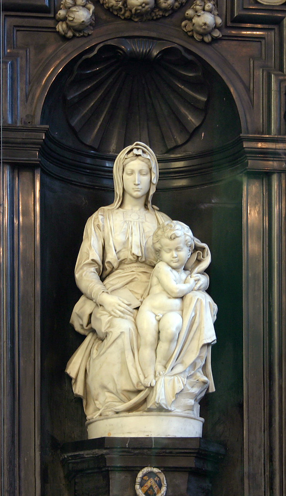
The Madonna of Bruges is a marble sculpture by Michelangelo of the Virgin and Child.
Sight 15: Church of Our Lady
Get Ticket*
The Church of Our Lady is a Roman Catholic church in Bruges, Belgium, dating mainly from the 13th, 14th and 15th centuries. Its 115.6-metre-high (379 ft) tower remains the tallest structure in the city and the third tallest brickwork tower in the world.
Wikipedia: Church of Our Lady, Bruges (EN), Heritage Website
Sight 16: PAX

The Pax is a work of art by the Belgian sculptor Octave Rotsaert.
Sight 17: Sint-Janshospitaal
Get Ticket*
The Hospital of St. John was a medieval hospital in Bruges. It was founded in the mid-12th century.
Sight 18: Begijnhof Ten Wijngaerde

The Princely Beguinage Ten Wijngaerde is the only preserved beguinage in Bruges, Belgium. There are no more beguines living there, but since 1927, it has functioned as a convent for Benedictines, founded by canon Hoornaert. In the same year, the houses at the west side were also reshaped and enlarged into the Monasterium De Wijngaard, a priory of Benedictine nuns.
Wikipedia: Ten Wijngaerde (Begijnhof Brugge) (EN), Heritage Website
Sight 19: Minnewaterpark

The Minnewaterpark is a city park in the south of the historic city centre of Bruges, adjacent to the historic water surface, called Minnewater.
Sight 20: Gentpoortvest

The Gentpoortvest is a street in Bruges.
Sight 21: Koningin Astridpark

The Koningin Astridpark is a park in the centre of Bruges.
Sight 22: Sint-Magdalena en Sint-Catharinakerk

The Church of Saint Magdalene is a nineteenth-century parish church in Bruges.
Wikipedia: Heilige Magdalenakerk (Brugge) (NL), Heritage Website
Sight 23: Marieke

Marieke is a 1988 statue in Bruges, Belgium, designed by Jef Claerhout. It is a homage to Jacques Brel's famous song Marieke.
Sight 24: Kazernevest

The Kazernevest is a promenade and a street in Bruges.
Sight 25: Heilige Familiekerk

The Holy Family Church is located in the Bilkske in the Langestraatkwartier, in the city center of Bruges.
Wikipedia: Heilige Familiekerk (Brugge) (NL), Heritage Website
Share
How likely are you to recommend us?
Disclaimer Please be aware of your surroundings and do not enter private property. We are not liable for any damages that occur during the tours.
GPX-Download For navigation apps and GPS devices you can download the tour as a GPX file.