Self-guided Sightseeing Tour #3 in Bruges, Belgium
Legend
Guided Free Walking Tours
Book free guided walking tours in Bruges.
Guided Sightseeing Tours
Book guided sightseeing tours and activities in Bruges.
Tour Facts
10.6 km
115 m
Experience Bruges in Belgium in a whole new way with our free self-guided sightseeing tour. This site not only offers you practical information and insider tips, but also a rich variety of activities and sights you shouldn't miss. Whether you love art and culture, want to explore historical sites or simply want to experience the vibrant atmosphere of a lively city - you'll find everything you need for your personal adventure here.
Activities in BrugesIndividual Sights in BrugesSight 1: Sint-Baafskerk

St. Bavo's Church in the Belgian city of Bruges is located in the Sint-Baafs district in the borough of Sint-Andries. The church has been in use since 1934. This is almost twenty years after the establishment of the parish. On October 11, 1937, the solemn church consecration took place.
Sight 2: Smedenpoort

The Smedenpoort is one of the four remaining city gates of Bruges. The first gate dates from 1297-1299, but was rebuilt in 1367-1368 by the master masons Jan Slabbaert and Mathias Saghen. Later, it was rebuilt a few times. Characteristic of this gate is that, just like the Donkey Gate, it is completely surrounded by water.
Sight 3: Godshuizen Van Der Meulen

Van der Meulen is the name of several almshouses in Bruges.
Sight 4: Onze-Lieve-Vrouw-van-Blindekenskapel

The Chapel of Our Lady of the Blind on the Kreupelenstraat in Bruges was erected, according to tradition, after a promise made in the aftermath of the Battle of Pevelenberg that a 36-pound candle would be brought to the Onze-Lieve-Vrouw ter Potterie every year. This promise was made by the husbands and mothers who stayed behind if their loved ones would return from the battle in one piece.
Sight 5: Boeverievest

The Buiten Boeverievest is a street in Bruges, Belgium, which is part of the second medieval moat.
Sight 6: Oud Waterhuis
The Waterhuis consists of two buildings, located opposite each other between the Boeveriepoort and the Smedenpoort on the fortifications of Bruges. The old water house is located along the Hendrik Consciencelaan, near the Fonteinstraat. The new water house is located along the Buiten Boeverievest, on the other bank of the inner moat.
Sight 7: Dienstencentrum Van Volden

Van Volden is a seventeenth-century foundation in Bruges.
Wikipedia: Godshuis Van Volden (NL), Website, Heritage Website
Sight 8: Godshuis De Moor

De Moor is a series of almshouses in the Boeveriestraat in Bruges.
Sight 9: Concertgebouw
Get Ticket*
The Concertgebouw is a cultural centre in Bruges, Belgium. Located at 't Zand, it was completed in 2002 when Bruges was European Capital of Culture, designed by Paul Robbrecht and Hilde Daem.
Sight 10: PAX

The Pax is a work of art by the Belgian sculptor Octave Rotsaert.
Sight 11: Sint-Janshospitaal
Get Ticket*
The Hospital of St. John was a medieval hospital in Bruges. It was founded in the mid-12th century.
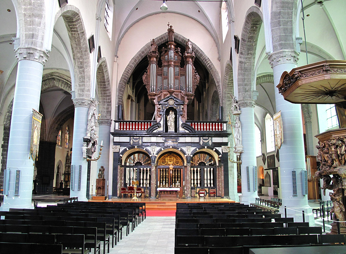
Sight 12: Church of Our Lady
Get Ticket*
The Church of Our Lady is a Roman Catholic church in Bruges, Belgium, dating mainly from the 13th, 14th and 15th centuries. Its 115.6-metre-high (379 ft) tower remains the tallest structure in the city and the third tallest brickwork tower in the world.
Wikipedia: Church of Our Lady, Bruges (EN), Heritage Website
Sight 13: Madonna of Bruges
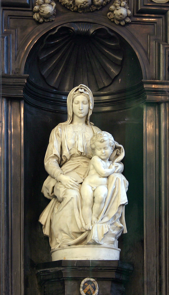
The Madonna of Bruges is a marble sculpture by Michelangelo of the Virgin and Child.
Sight 14: Hof Arents

The Arentshof in the Belgian city of Bruges is a garden, adjacent to the Arentshuis.
Sight 15: Groeningemuseum

The Groeningemuseum is a municipal museum in Bruges, Belgium, built on the site of the medieval Eekhout Abbey.
Sight 16: Frank Brangwyn-Arentshuis

The Arentshuis is a former museum in Bruges. Together with the Groeninge Museum, the Fine Arts from the 15th to the 21st century were housed here. The Arentshuis is located on the Dijver. It was part of Musea Brugge.
Sight 17: Gruuthusemuseum

The Gruuthusemuseum is a museum of applied arts in Bruges, Belgium, located in the medieval Gruuthuse, the house of Louis de Gruuthuse. The collection ranges from the 15th to the 19th century.
Sight 18: Simon Stevinplein

Simon Stevinplein is a square in Bruges, situated between the Steenstraat and the Oude Burg. On the square is the statue of Bruges-born mathematician and physicist Simon Stevin. The oldest market square in Bruges was probably located here, before the Markt was built.
Sight 19: Belfry
Get Ticket*
The Belfry of Bruges is a medieval bell tower in the centre of Bruges, Belgium. One of the city's most prominent symbols, the belfry formerly housed a treasury and the municipal archives and served as an observation post for spotting fires and other dangers.
Sight 20: Provinciaal Hof

The Provinciaal Hof is a neo-Gothic building on the Markt in Bruges, Belgium. It is the former meeting place for the Provincial Government of West Flanders.
Sight 21: Historium
Get Ticket*
The Historium is a cultural-historical attraction on the Grote Markt in Bruges. On the basis of various experiences, one can see how Bruges was vibrant during the Golden Age in the time of Jan Van Eyck. It also includes a Duvel café with free admission, a virtual reality experience, a terrace with panoramic views, a Gothic tower and a department of the municipal tourist office.
Sight 22: Eiermarkt
Get Ticket*
The Eiermarkt is a small square in Bruges.
Sight 23: Godshuizen De Vette Vischpoort

The Vette Vispoort is the name of a house of worship in Bruges.
Sight 24: St. James's Church
St. James's Church (Sint-Jakobskerk) is a Catholic church in Bruges, Belgium. Originally built around 1240, the church was considerably expanded in 1459 to match the rising affluence of Bruges, and was patronized by the Duke of Burgundy. In the late 17th and early 18th centuries the church's interior was remodeled in its present Baroque style.
Wikipedia: St. James's Church, Bruges (EN), Heritage Website
Sight 25: Stadsschouwburg
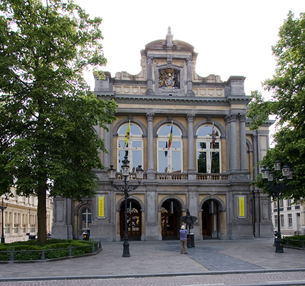
Built in 1869, the Royal City Theatre of Bruges is one of the most important theatre and concert halls in the West Flemish capital and is considered one of the best-preserved city theatres in Europe.
Sight 26: Poortersloge

The Poortersloge in the Belgian city of Bruges is located on the Jan van Eyckplein, diagonally opposite the Tolhuis. It is located in the part of Bruges that focused on international trade in the late Middle Ages.
Sight 27: Archeologische site van de Sint-Donaaskathedraal
St. Donatian's Cathedral was a Roman Catholic cathedral in Bruges, Belgium. Located on the Burg, one of the main squares in the city, it was the largest church in Bruges. The cathedral was destroyed in 1799 in the wake of the dissolution of the Diocese of Bruges during the aftermath of the French Revolution.
Sight 28: Basilica of the Holy Blood
Get Ticket*
The Basilica of the Holy Blood is a Roman Catholic basilica in Bruges, Belgium. The church houses a relic of the Holy Blood allegedly collected by Joseph of Arimathea and brought from the Holy Land by Thierry of Alsace, Count of Flanders. Built between 1134 and 1157 as the chapel of the Count of Flanders, it was promoted to a minor basilica in 1923.
Wikipedia: Basilica of the Holy Blood (EN), Website, Heritage Website
Sight 29: City Hall

The City Hall of Bruges, West Flanders, Belgium, is a landmark building and the seat of that city. Built in a late-Gothic monumental style between 1376 and 1421, it is one of the oldest city halls in the former Burgundian Netherlands. It is located on Burg Square, the area of the former fortified castle in the centre of Bruges.
Sight 30: Oude Civiele Griffie

The Old Civil Registry is one of the oldest Renaissance buildings in Flanders. It is located on Burg Square in Bruges, between the Manor of the Franc of Bruges and the City Hall.
Sight 31: Blinde-Ezelstraat

The Blinde-Ezelstraat is a street in the heart of the historic centre of Bruges.
Sight 32: Koningin Astridpark

The Koningin Astridpark is a park in the centre of Bruges.
Sight 33: Sint-Magdalena en Sint-Catharinakerk

The Church of Saint Magdalene is a nineteenth-century parish church in Bruges.
Wikipedia: Heilige Magdalenakerk (Brugge) (NL), Heritage Website
Sight 34: St. Walburga Church

The St. Walburga Church is a 17th-century Roman-Catholic church in Bruges built by the Jesuits in a Baroque style. It is now a parish church and contains many valuable art objects.
Wikipedia: St. Walburga Church (Bruges) (EN), Heritage Website
Sight 35: Minneboplein

The Minneboplein in Bruges was created after the demolition of a factory building in 1975 and makes the connection between the Sint-Annarei and the Molenmeers along the Leffingestraat.
Sight 36: Godshuizen Cobrysse

The Godshuis Cobrysse is a house of worship in Bruges, located in the Leffingestraat.
Sight 37: Jeruzalemkerk

The Jerusalem Church or Jerusalem Chapel in Bruges was built in the first half of the 15th century by descendants of Opicius Adornes, who came from Genoa and came to Flanders in the 13th century.
Sight 38: Guido Gezellewarande
The Guido Gezellewarande is a public park in the quarter of Bruges in the city of Bruges, named after the poet Guido Gezelle.
Sight 39: Kruisvest

The Kruisvest is a promenade and street in Bruges.
Sight 40: Bonne Chiere

The Bonne-Chière mill in the city of Bruges is located on the Kruisvest, on the edge of the city centre. The mill was built in 1844 and functions as a corn and oil mill.
Sight 41: Kruispoort
Get Ticket*
The Kruispoort in Bruges is one of the remaining city gates and is a witness to medieval military architecture.
Sight 42: Heilige Familiekerk

The Holy Family Church is located in the Bilkske in the Langestraatkwartier, in the city center of Bruges.
Wikipedia: Heilige Familiekerk (Brugge) (NL), Heritage Website
Sight 43: Kazernevest

The Kazernevest is a promenade and a street in Bruges.
Share
How likely are you to recommend us?
Disclaimer Please be aware of your surroundings and do not enter private property. We are not liable for any damages that occur during the tours.
GPX-Download For navigation apps and GPS devices you can download the tour as a GPX file.