15 Sights in Los Angeles County, United States (with Map and Images)
Legend
Premium Sights
Book tickets, guided tours and activities in Los Angeles County.
Guided Free Walking Tours
Book free guided walking tours in Los Angeles County.
Welcome to your journey through the most beautiful sights in Los Angeles County, United States! Whether you want to discover the city's historical treasures or experience its modern highlights, you'll find everything your heart desires here. Be inspired by our selection and plan your unforgettable adventure in Los Angeles County. Dive into the diversity of this fascinating city and discover everything it has to offer.
Sightseeing Tours in Los Angeles CountyActivities in Los Angeles County1. St. Francis Dam

The St. Francis Dam, or the San Francisquito Dam, was a concrete gravity dam located in San Francisquito Canyon in northern Los Angeles County, California, United States, that was built between 1924 and 1926. The dam failed catastrophically in 1928, killing at least 431 people in the subsequent flood, in what is considered to have been one of the worst American civil engineering disasters of the 20th century and the third-greatest loss of life in California history.
2. Vasquez Rocks
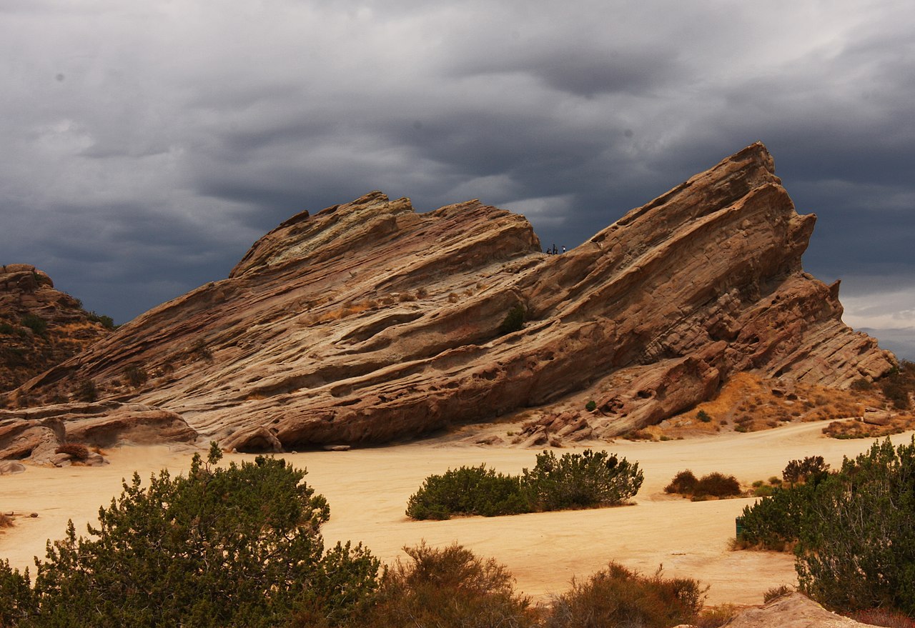
Vasquez Rocks Natural Area Park is a 932-acre (377-hectare) park located in the Sierra Pelona in northern Los Angeles County, California. It is known for its rock formations, the result of sedimentary layering and later seismic uplift. It is located near the town of Agua Dulce, between the cities of Santa Clarita and Palmdale. The area is visible from the Antelope Valley Freeway. Its location approximately 25 miles (40 km) from downtown Los Angeles places it within Hollywood's "studio zone" and makes it a popular filming location for films and television programs.
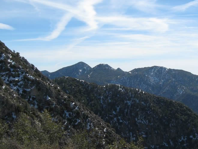
3. Mount San Antonio

Mount San Antonio, commonly referred to as Mount Baldy or Old Baldy, is a 10,064 ft (3,068 m) summit in the San Gabriel Mountains on the border of Los Angeles and San Bernardino counties of California. Lying within the San Gabriel Mountains National Monument and Angeles National Forest, it is the highest point within the mountain range, the County of Los Angeles, and the Los Angeles metropolitan area.
4. Mount Wilson Observatory

The Mount Wilson Observatory (MWO) is an astronomical observatory in Los Angeles County, California, United States. The MWO is located on Mount Wilson, a 5,710-foot (1,740-meter) peak in the San Gabriel Mountains near Pasadena, northeast of Los Angeles.
5. Llano del Rio

Llano del Rio was a commune located in what is now Llano, California, east of Palmdale in the Antelope Valley, Los Angeles County. The colony was devised by lawyer and socialist politician Job Harriman after he had failed his bid to become the mayor of Los Angeles in 1911. The colony's land was acquired in 1913 and it was formally launched on May 1, 1914.
6. Bridge to Nowhere

The Bridge to Nowhere is an arch bridge that was built in 1936 north of Azusa, California, United States in the San Gabriel Mountains. It spans the East Fork of the San Gabriel River and was meant to be part of a road connecting the San Gabriel Valley with Wrightwood, California.
7. Mount Baden-Powell

Mount Baden-Powell is a peak in the San Gabriel Mountains of California named for the founder of the World Scouting Movement, Robert Baden-Powell, 1st Baron Baden-Powell. It was officially recognized by the USGS at a dedication ceremony in 1931. It was originally known as East Twin or North Baldy.
8. Workman and Temple Family Homestead Museum

The Workman and Temple Family Homestead Museum is a historic house museum located at 15415 East Don Julian Road in City of Industry, California, that features the homes and private cemetery that belonged to the pioneer Workman-Temple family.
Wikipedia: Workman and Temple Family Homestead Museum (EN), Website
9. Mount Islip

Mount Islip is a 8,250-foot (2,515 m) peak in the Angeles National Forest in California, United States. On a clear day the sharp, high peak provides impressive views of the Mojave Desert, the Los Angeles Basin, Santa Catalina Island, and San Clemente Island.
10. Strawberry Peak

Strawberry Peak is a prominent peak in the San Gabriel Mountains of Los Angeles County, California. It is located about 10 miles (16 km) north of Pasadena, and 28 miles (45 km) from Los Angeles, along the Angeles Crest Highway. Strawberry Peak is the tallest of the front range peaks, being three feet higher than nearby San Gabriel Peak. Both can be widely seen from greater Los Angeles and the San Gabriel Valley, and are popular with hikers. Other prominent nearby peaks include Josephine Peak and Mount Wilson. Strawberry Peak was named by mountaineers over a century ago, who felt the peak resembled an enormous upside-down strawberry.
11. Mount Burnham

Mount Burnham is one of the highest peaks in the San Gabriel Mountains. It is in the Sheep Mountain Wilderness. It is named for Frederick Russell Burnham the famous American military scout who taught Scoutcraft to Robert Baden-Powell and became one of the inspirations for the founding of the Boy Scouts. Mount Burnham was officially recognized by the USGS at a dedication ceremony in 1951. It was original known as "North Baldy Mountain". The peak is within Los Angeles County, about 16 miles (26 km) north of Glendora, and 66 miles (106 km) from Los Angeles. In 1956, Mount Burnham was added to the list of Signature Summits by the Hundred Peaks Section of the Sierra Club.
12. SS Dominator
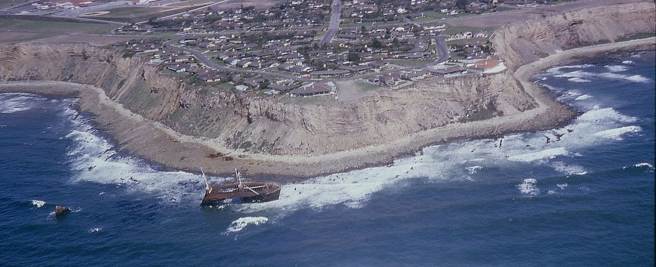
SS Dominator, a freighter, ran ashore on the Palos Verdes Peninsula in the South Bay area of California in 1961 due to a navigational error while lost in fog. Its remains can still be seen today and serves as a point of interest for hikers and kayakers.
13. Mount Orizaba

Mount Orizaba is the highest peak on Santa Catalina Island, California, United States. The summit is at 2,097 feet (639 m). On January 10, 1949, 8 inches (200 mm) of snow fell on the mountain. There is an FAA VORTAC installation at the summit. It is named after Pico de Orizaba, the tallest peak in Mexico.
14. San Gabriel Peak
San Gabriel Peak is a summit in the San Gabriel Mountains in the U.S. state of California. It was named by the United States Geological Survey in 1894 and is located in the Angeles National Forest. This peak was first named The Commodore for Commodore Perry Switzer.
15. Tuf Quarry Mill

Fairmont Butte is a butte of volcanic origins in the Antelope Valley just west of the City of Lancaster, California in Los Angeles County. Summit elevation is 3,130 feet above sea level. Parts of Fairmont Butte are situated within the boundaries of Antelope Valley California Poppy Reserve.
Share
How likely are you to recommend us?
Disclaimer Please be aware of your surroundings and do not enter private property. We are not liable for any damages that occur during the tours.