82 Sights in Hartford, United States (with Map and Images)
Legend
Welcome to your journey through the most beautiful sights in Hartford, United States! Whether you want to discover the city's historical treasures or experience its modern highlights, you'll find everything your heart desires here. Be inspired by our selection and plan your unforgettable adventure in Hartford. Dive into the diversity of this fascinating city and discover everything it has to offer.
Sightseeing Tours in HartfordActivities in Hartford1. Hartford Union Station

Hartford Union Station is a railroad station in Hartford, Connecticut, United States on the New Haven–Springfield Line. It is served by Amtrak Hartford Line, Northeast Regional, Valley Flyer, and Vermonter intercity rail service, plus CT Rail Hartford Line commuter rail service and CTfastrak bus rapid transit service.
2. Watkinson School

Watkinson School is a private co-educational independent day school in Hartford, Connecticut, United States. Watkinson is situated on Bloomfield Avenue adjacent to the University of Hartford. It serves students from 6th through 12th grade. Watkinson also offers a postgraduate option, called The Academy at Watkinson, which allows students who have just graduated from high school to spend an additional year taking courses at Watkinson as well as the University of Hartford. Watkinson is the oldest independent school located within the city limits of Hartford.
3. Cathedral of Saint Joseph

The Cathedral of St. Joseph in Hartford, Connecticut, United States, is the mother church and seat of the Archdiocese of Hartford. Dedicated on May 15, 1962, it stands on the site of the old cathedral which had been destroyed in a fire. It is located on Farmington Avenue just outside downtown Hartford.
Wikipedia: Cathedral of St. Joseph (Hartford, Connecticut) (EN), Website, Heritage Website
4. Morgan G. Bulkeley Bridge

The Bulkeley Bridge is the oldest of three highway bridges over the Connecticut River between Hartford, Connecticut and East Hartford, Connecticut. A stone arch bridge composed of nine spans, the bridge carries Interstate 84, U.S. Route 6, and U.S. Route 44 across the river. As of 2005, the bridge carried an average daily traffic of 142,500 cars. The arches are mounted on stone piers, and vary in length from 68 feet (21 m) to 119 feet (36 m); the total length of the bridge is 1,192 feet (363 m).
5. Town of Hartford Historic District

Wilder is an unincorporated village and census-designated place (CDP) within the town of Hartford in Windsor County, Vermont, United States. It is the location of the Wilder Dam on the Connecticut River. The population of the CDP was 1,690 at the 2010 census. The village center is an early example of a planned mill community, and was listed on the National Register of Historic Places as the Wilder Village Historic District in 1999.
6. Colt Armory

The Colt Armory is a historic factory complex for the manufacture of firearms, created by Samuel Colt. It is located in Hartford, Connecticut along the Connecticut River, and as of 2008 is part of the Coltsville Historic District, named a National Historic Landmark District. It is slated to become part of Coltsville National Historical Park, now undergoing planning by the National Park Service.
7. Old State House

The Old State House in Hartford, Connecticut is generally believed to have been designed by noted American architect Charles Bulfinch as his first public building. The State House is currently managed by the Office of Legislative Management of the Connecticut General Assembly.
Wikipedia: Old State House (Connecticut) (EN), Heritage Website
8. Bushnell Center for the Performing Arts

The Bushnell Center for the Performing Arts is a performing arts venue at 166 Capitol Street in Hartford, Connecticut. Managed by a non-profit organization, it is marketed as Connecticut's premier presenter of the performing arts.
Wikipedia: The Bushnell Center for the Performing Arts (EN), Website
9. Ancient Burying Ground

The First Church of Christ and the Ancient Burying Ground is a historic church and cemetery at 60 Gold Street in Hartford, Connecticut, United States. It is the oldest church congregation in Hartford, founded in 1636 by Thomas Hooker. The present building, the congregation's fourth, was built in 1807, and was listed on the National Register of Historic Places in 1972. The adjacent cemetery, formally set apart in 1640, was the city's sole cemetery until 1803.
Wikipedia: First Church of Christ and the Ancient Burying Ground (EN), Heritage Website
10. Connecticut Museum of Culture and History

The Connecticut Museum of Culture and History (CMCH), formerly the Connecticut Historical Society, is a private, non-profit organization that serves as the official state historical society of Connecticut. Established in Hartford in 1825, the CMCH is one of the oldest historical societies in the US.
Wikipedia: Connecticut Museum of Culture and History (EN), Website
11. Connecticut Science Center
The Connecticut Science Center is a nine-story museum located on the Connecticut River in Hartford, Connecticut designed by César Pelli & Associates, which opened on June 12, 2009. The building measures a total of 154,000 square feet (14,300 m2), including 40,000 square feet (3,700 m2) of interactive exhibits consisting of videos, audios, visuals, tactile components, programs, and live demonstrations.
12. Armsmear

Armsmear, also known as the Samuel Colt Home, is a historic house located at 80 Wethersfield Avenue in Hartford, Connecticut. It was the family home of firearm manufacturer Samuel Colt. Armsmear was listed as a National Historic Landmark in 1976; this designation was expanded in 2008 to form the Coltsville Historic District, a National Historic Landmark District.
13. Holy Trinity Roman Catholic Church

Holy Trinity Roman Catholic Church is a parish church in the Archdiocese of Hartford located in Hartford, Connecticut, United States. The parish was founded by Lithuanian immigrants within the 20th century. Construction of the church began in 1912.
Wikipedia: Holy Trinity Roman Catholic Church (Hartford, Connecticut) (EN), Website
14. Saint Cyril and Saint Methodius Church

SS. Cyril and Methodius Parish - one of the Polish-American Roman Catholic parishes in New England in the Archdiocese of Hartford. Founded on April 6, 1902, it is designated for Polish immigrants in Hartford, Connecticut, United States.
Wikipedia: SS. Cyril and Methodius Parish, Hartford (EN), Website
15. Saint Patrick-Saint Anthony Church

St. Patrick - St. Anthony Church is a Cathedral-style Church located at 265 Church Street, Hartford, CT. The church is part of the Roman Catholic Archdiocese of Hartford. It is the oldest Roman Catholic parish in the state of Connecticut.
Wikipedia: St. Patrick - St. Anthony Church (Hartford, Connecticut) (EN), Website, Heritage Website
16. Faith Congregational Church

Faith Congregational Church is a historic church at 2030 Main Street in Hartford, Connecticut. The brick Romanesque Revival-style church building, completed in 1872, now houses Faith Congregational Church, whose lineage includes the city's oldest African-American congregation, established in 1819. The church is a stop on the Connecticut Freedom Trail and was listed on the United States National Register of Historic Places in 1993.
Wikipedia: Windsor Avenue Congregational Church (EN), Website, Heritage Website
17. Christ Church Catherdral Churchyard

Christ Church Cathedral is a historic church at 955 Main Street in downtown Hartford, Connecticut. Built in the 1820s to a design by Ithiel Town, it is one of the earliest known examples of Gothic Revival architecture in the United States. It was listed on the National Register of Historic Places in 1983. It is the cathedral church of the Episcopal Diocese of Connecticut, whose offices are next door at 45 Church Street.
Wikipedia: Christ Church Cathedral (Hartford, Connecticut) (EN), Heritage Website
18. Soldiers and Sailors Memorial Arch

The Soldiers and Sailors Memorial Arch in Bushnell Park, Hartford, Connecticut, honors the 4,000 Hartford citizens who served in the American Civil War, including 400 who died for the Union cause. It is notable as the first permanent memorial arch to be built in America.
19. Engine Company 2 Fire Station

The Engine Company 2 Fire Station is a firehouse at the corner of Main and Belden streets in Hartford, Connecticut, United States. It is a brick structure built in the early 20th century, the second firehouse built for the company. Architect Russell Barker, who designed many public buildings in the city, used the Italian Renaissance Revival style, unusual for a firehouse. The front facade boasts intricate brickwork. It is one of two remaining firehouses in the city originally designed to accommodate both men and horses. In 1989, it was added to the National Register of Historic Places along with several other city firehouses. It continues to serve its original function, housing Engine Company 2 of the Hartford Fire Department.
Wikipedia: Engine Company 2 Fire Station (EN), Heritage Website
20. Good Shepherd Church

The Church of the Good Shepherd and Parish House is an Episcopal church at 155 Wyllys Street in Hartford, Connecticut. It was commissioned by Elizabeth Jarvis Colt, the widow of Samuel Colt, and completed in 1867. The church and its associated parish house were designed by Edward Tuckerman Potter, and serve as a memorial to Samuel Colt and members of his family. The church and parish house were added to the National Register of Historic Places in 1975, and became a contributing property to the Coltsville Historic District in 2008.
Wikipedia: Church of the Good Shepherd and Parish House (EN), Heritage Website
21. Coltsville Historic District
Coltsville Historic District is a National Historic Landmark District in Hartford, Connecticut. The district encompasses the factory, worker housing, and owner residences associated with Samuel Colt (1814-1862), one of the nation's early innovators in precision manufacturing and the production of firearms. It was the site of important contributions to manufacturing technology made by Colt and the industrial enterprise he created. Coltsville is a cohesive and readily identifiable 260-acre (110 ha) area, part of which was originally listed as the Colt Industrial District on the National Register of Historic Places in 1976. It was designated a National Historic Landmark in 2008.
Wikipedia: Coltsville Historic District (EN), Heritage Website
22. Phoenix Life Insurance Company Building

The Phoenix Mutual Life Insurance Building, locally called the "Boat Building", is a notable Modernist office building located on Constitution Plaza in Hartford, Connecticut. Designed by Max Abramovitz and completed in 1963, it is listed on the National Register of Historic Places and is the world's first two-sided building.
Wikipedia: Phoenix Life Insurance Company Building (EN), Heritage Website
23. Ann Street Historic District

The Ann Street Historic District is a historic district encompassing part of Downtown Hartford in Hartford, Connecticut. A commercial and light industrial area, the district includes properties along Ann Uccello Street from Chapel Street south to Hicks Street. It also includes properties east of Ann Street fronting Pearl Street and Hicks Street to roughly Haynes Street, as well as properties west of Ann Uccello Street fronting Allyn and Asylum Streets to roughly a third of the block. The district's architecture typifies the city's development between about 1880 and 1930; it was listed on the National Register of Historic Places in 1983.
Wikipedia: Ann Street Historic District (EN), Heritage Website
24. High Street Historic District

The High Street Historic District of Hartford, Connecticut is a 1.1-acre (0.45 ha) historic district that includes three buildings typifying the architectural styles of the late 19th and early 20th centuries in the city. It was listed on the National Register of Historic Places in 1998. The buildings are located at 402-418 Asylum Street, 28 High Street, and 175-189 Allyn Street, and includes the Batterson Block and Judd and Root Building, each individually listed for their architecture.
Wikipedia: High Street Historic District (Hartford, Connecticut) (EN), Heritage Website
25. Goodwin Hotel

The Goodwin Hotel, is a historic hotel and apartment building located in downtown Hartford, Connecticut. Known for its distinctive English Queen Anne terracotta facade, the building was originally developed as an apartment building by brothers James J. Goodwin and Rev. Francis Goodwin and opened in 1881. It was designed by Francis Kimball and was modeled on buildings Rev. Goodwin had seen being constructed at the time in England. Kimball, of the firm of Kimball & Wisedell, was the architect for the Day House in Hartford, which also has an English Queen Anne design. The Goodwin Building was expanded in 1891 to Ann Street and in 1900 to Pearl Street. It was a very prestigious address at the time, with even J.P. Morgan living there during his visits to the city of his birth.
26. Templo Sion Pentecostal

St. Paul's Methodist Episcopal Church, known more recently as the Templo Sion Pentecostal Church, is a historic church at 1886-1906 Park Street in Hartford, Connecticut, United States. Built in 1900, it is a good example of Romanesque Revival design. It was built for a working-class congregation to a design by the nationally known church architect George W. Kramer, proponent of the Akron plan of church interiors, which this one follows. The church was added to the National Register of Historic Places in 1984.
Wikipedia: St. Paul's Methodist Episcopal Church (Hartford, Connecticut) (EN), Website, Heritage Website
27. Frog Hollow Historic District

Frog Hollow is one of the neighborhoods of Hartford, Connecticut. It is a predominantly working-class residential area, bounded on the north by Capitol Avenue, the east by Lafayette Street, the south by Madison and Hamilton Streets, and on the west by Interstate 84. The neighborhood was developed between about 1850 and 1930, and still contains a remarkable concentration of residential housing from that period. The entire neighborhood, covering more than 150 acres (61 ha) and including more than 900 buildings, is listed on the National Register of Historic Places.
Wikipedia: Frog Hollow, Hartford, Connecticut (EN), Heritage Website
28. South Congregational Church

The Second Church of Christ, known more recently as the South Congregational Church, is a historic church in Hartford, Connecticut. Built in 1825–27, it is one of the oldest surviving public buildings in the city. It is the third home of its congregation, which was founded in 1670, and is one of the oldest purely Congregationalist groups in the nation. The building was listed on the National Register of Historic Places in 1978.
Wikipedia: Second Church of Christ (EN), Website, Heritage Website
29. Pratt Street Historic District

The Pratt Street Historic District of Hartford, Connecticut, encompasses all of Pratt Street, between Main and Trumbull Streets, in the city's downtown. This block, which includes 15 buildings, is the only place in the city where its typical early 20th-century streetscape is retained. All of the buildings in the district were built between 1830 and 1928, a significant number of them designed by major local architects. The district was listed on the National Register of Historic Places in 1983.
Wikipedia: Pratt Street Historic District (EN), Heritage Website
30. Charter Oak Cultural Center

Temple Beth Israel, sometimes called Charter Oak Temple, is an historic former Reform Jewish synagogue and later church building, now cultural center, located at 21 Charter Oak Avenue, in Hartford, Connecticut, in the United States.
Wikipedia: Temple Beth Israel (Hartford, Connecticut) (EN), Website, Heritage Website
31. Union Baptist Church

The Union Baptist Church is a historic church at 1913 and 1921 Main Street in Hartford, Connecticut. Originally built by an Episcopal congregation, it has for many years been home to an African-American Baptist congregation, which under the leadership of Rev. John C. Jackson (1866-1953), played a significant role in advancing the cause of civil rights in the state. The church, and its adjacent parsonage, were listed on the National Register of Historic Places in 1979.
Wikipedia: Union Baptist Church (Hartford, Connecticut) (EN), Website, Heritage Website
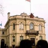
32. Hartford City Hall

The Hartford Municipal Building, also known as Hartford City Hall, is a historic Beaux-Arts structure located at 550 Main Street in Hartford, Connecticut. Completed in 1915, it is a prominent local example of Beaux-Arts architecture, and is the third building to serve as city hall. It was added to the National Register of Historic Places in 1981.
Wikipedia: Municipal Building (Hartford, Connecticut) (EN), Heritage Website
33. Engine Company 1 Fire Station

The South Green Fire Station, also known as the Engine Company 1 Fire Station, is at 197 Main St. in downtown Hartford, Connecticut. Built in 1927, it is an architecturally distinctive example of Classical and Collegiate Gothic Revival architecture, designed by a prominent local firm. The station, as well as the former fire equipment maintenance house behind it at 36 John Street, were listed on the National Register of Historic Places in 1989. The station presently houses Engine Company 1 and Ladder Company 6 of the Hartford Fire Department.
Wikipedia: Engine Company 1 Fire Station (EN), Heritage Website
34. House of God Church

Chevry Lomday Mishnayes Synagogue is a historic former synagogue building at 148-150 Bedford Street in Hartford, Connecticut, in the United States. Built in 1924, it is unusual for an ecclesiastical structure in that its design appears to be based on that of an apartment house. It housed an Orthodox Jewish congregation until 1963, and now houses the local House of God Church. It was listed on the National Register of Historic Places in 1995.
Wikipedia: Chevry Lomday Mishnayes Synagogue (EN), Heritage Website
35. Quechee State Park

The Quechee State Park is located on US Route 4 in Quechee, Vermont. The park land is owned by the US Army Corps of Engineers and leased from by the State of Vermont. The park contains the Quechee Gorge, a popular Vermont tourist stop. The land was originally the site of the Dewey wool mill which ceased operation in 1952 and relocated to Enfield, New Hampshire. Shortly after the closing of the Mill the US Army Corps of Engineers acquired the property as part of its regional flood control plan. A hydroelectric dam sits at the north end of the gorge.
36. Downtown North Historic District

The Downtown North Historic District is a 19-acre (7.7 ha) historic district in Hartford, Connecticut. It is a predominantly residential area located around Main Street and High Street north of I-84 and south of the Amtrak railroad tracks. Its apartment blocks, houses, schools and churches, built up mainly in the late 19th and early 20th centuries as part of an expansion of the city's urban core. It includes the 130-foot (40 m) Keney Tower. The area was listed on the National Register of Historic Places in 2004.
Wikipedia: Downtown North Historic District (Hartford, Connecticut) (EN), Heritage Website
37. Metropolitan African Methodist Episcopal Zion Church

The Metropolitan African Methodist Episcopal Zion Church is a historic Methodist Episcopal Church at 2051 Main Street in Hartford, Connecticut. This High Victorian Gothic structure was built in 1873-74 for an Episcopal congregation, and has since 1926 been the home to the city's oldest African-American congregation, which was established in 1833. The church was listed on the National Register of Historic Places in 1994.
Wikipedia: Metropolitan African Methodist Episcopal Zion Church (EN), Website, Heritage Website
38. Elks Lodge
The B.P.O. Elks Lodge is a historic fraternal lodge building at 34 Prospect Street in Hartford, Connecticut. It is a Classical Revival architecture building designed by John J. Dwyer, and built in 1903 for the local chapter of the Benevolent and Protective Order of Elks. The building was listed on the National Register of Historic Places in 1984 for its architecture.
Wikipedia: B.P.O. Elks Lodge (Hartford, Connecticut) (EN), Heritage Website
39. Engine Company 15 Fire Station

The Engine Company 15 Fire Station is located at 8 Fairfield Avenue in Hartford, Connecticut. It was built in 1909, and is one of two surviving firehouses in the city which was built to stable horses. It was listed on the National Register of Historic Places on March 2, 1989. It presently houses Engine Company 15 and Ladder Company 2 of the Hartford Fire Department.
Wikipedia: Engine Company 15 Fire Station (EN), Heritage Website
40. Clay Hill Historic District

The Clay Hill Historic District in Hartford, Connecticut is a 60-acre (24 ha) historic district that was listed on the National Register of Historic Places in 1983, and expanded in 1984. Northwest of Downtown Hartford, the district is roughly bounded by Main, Mather, Garden, and Walnut Streets. The district contains examples of Queen Anne, Italianiate and Neoclassical Revival architecture.
Wikipedia: Clay Hill Historic District (EN), Heritage Website
41. Elm Street Historic District

The Elm Street Historic District encompasses a collection of architecturally distinguished institutional and residential buildings near the Connecticut State Capitol in Hartford, Connecticut. Located on Capitol Avenue and Trinity and Elm Streets, it includes the city's best concentration of early 20th-century architecture, including Bushnell Memorial Hall and several state office buildings. It was listed on the National Register of Historic Places in 1984.
Wikipedia: Elm Street Historic District (Hartford, Connecticut) (EN), Heritage Website
42. Engine Company 16 Fire Station

The Engine Company 16 Fire Station, also known as the Blue Hills Fire Station, is located at 636 Blue Hills Avenue in Hartford, Connecticut. Built in 1928, it is one of the city's most architecturally distinctive fire stations, a Tudor Revival structure designed by the local firm of Ebbets & Frid. The building was listed on the National Register of Historic Places on March 2, 1989. It continues to serve its original function, housing Engine Company 16 of the Hartford Fire Department.
Wikipedia: Engine Company 16 Fire Station (EN), Website, Heritage Website
43. Main Street Historic District No. 2

The Main Street Historic District No. 2 is a historic district in Hartford, Connecticut. It encompasses a city block in the city's downtown noted for its concentration of insurance-related highrise commercial buildings constructed in the early decades of the 20th century. It is visually dominated by the Travelers Tower, completed in 1919 and for many years Hartford's tallest building. The district was listed on the National Register of Historic Places in 1984, at which time it included seven contributing buildings over a nine-acre area.
Wikipedia: Main Street Historic District No. 2 (EN), Heritage Website
44. Engine Company 9 Fire Station

The Engine Company 9 Fire Station is located at 655 New Britain Avenue in Hartford, Connecticut. Built in 1929, it is a distinctive application of the Tudor Revival to firehouse design, and it was one of the city's first "suburban" fire stations, set in an originally less-developed outlying area. The building was listed on the National Register of Historic Places on March 2, 1989. It continues to serve its original function, housing Engine Company 9 of the Hartford Fire Department.
Wikipedia: Engine Company 9 Fire Station (EN), Heritage Website
45. Parkville Historic District

Parkville is a neighborhood on the west side of Hartford, Connecticut. Centered on Park Street and stretching from the railroad overpass just west of Pope Park to the West Hartford town line, and Capitol Avenue to Interstate 84, Parkville is a densely developed, mixed-use neighborhood that is mainly working-class. Its name is derived from its placement at the junction of the North and South Branches of the now-subterranean Park River. Most of the eastern half of the neighborhood was listed as a historic district on the National Register of Historic Places in 2015.
Wikipedia: Parkville, Hartford, Connecticut (EN), Heritage Website
46. Trinity College Chapel

The Trinity College Chapel is a Collegiate Gothic structure built in 1933 on the campus of Trinity College in Hartford, Connecticut. It was designed by Philip H. Frohman of the firm Frohman, Robb and Little, who also designed the National Cathedral in Washington D.C.
47. Hartford Water Tower

The Monette Water Tower is a historic elevated steel water tower located in Hartford, Arkansas. It was built in 1936 by the Chicago Bridge & Iron Company in conjunction with the Public Works Administration as part of a project to improve the local water supply. The project was one of 124 similar projects in the state funded by the PWA. It was added to the National Register of Historic Places in 2008, as part of a multiple-property listing that included numerous other New Deal-era projects throughout Arkansas.
48. Capewell Horse Nail Company

The Capewell Horse Nail Company is a historic brick industrial complex located in the Hartford, Connecticut neighborhood of Sheldon/Charter Oak. It was built in 1903 by industrialist George Capewell at the corner of Charter Oak Avenue and Popieluszko Court after the previous headquarters burned down.
Wikipedia: Capewell Horse Nail Company (EN), Heritage Website
49. Governor William A. O'Neill State Armory

The State Arsenal and Armory, formally the Governor William A. O'Neill State Armory and informally the Connecticut State Armory, is a historic military facility at 360 Broad Street in Hartford, Connecticut. Built in 1906, it is a distinctive example of Classical Revival architecture, built using then-innovative construction techniques involving concrete and cast stone. It was listed on the National Register of Historic Places in 1996. It serves as the headquarters of the Connecticut State Militia.
50. General Israel Putnam

General Israel Putnam is a monumental statue in Hartford, Connecticut, United States. Located in the city's Bushnell Park, the statue was designed by sculptor John Quincy Adams Ward and honors Israel Putnam, a military officer in the Continental Army during the American Revolutionary War. The statue was largely paid for by a donation from judge Joseph P. Allyn and was dedicated in a large ceremony in 1874. It was one of the first statues to be erected in the park, which nowadays houses several other monuments to famous Connecticut residents. From an artistic standpoint, the statue has received mixed reviews from critics.
51. Spring Grove Cemetery

Spring Grove Cemetery is a cemetery on Main Street in the Clay-Arsenal neighborhood of Hartford, Connecticut. Established in 1845, it is one of the city's oldest cemeteries, and its first private non-sectarian cemetery. Its burials include a number of the city's high-profile civic and business leaders, as well as a substantial indigent population, and artist Frederic Edwin Church. It was listed on the National Register of Historic Places in 2011.
Wikipedia: Spring Grove Cemetery (Hartford, Connecticut) (EN), Heritage Website
52. Hartford Stage

Hartford Stage is an American 501(c)(3) non-profit regional theatre company located on Church Street in downtown Hartford, Connecticut. Since its founding in 1963, Hartford Stage has won the Regional Theatre Tony Award (1989) and many Connecticut Critics Circle and other awards.
53. Jefferson–Seymour Historic District

The Jefferson-Seymour District is a historic district encompassing a residential area on the south side of Hartford, Connecticut. Covering portions of Cedar, Wadsworth, Seymour and Jefferson Streets, it contains a well-preserved collection of late 19th and early 20th-century middle-class residential architecture, primarily executed in brick. It was listed on the National Register of Historic Places in 1979.
Wikipedia: Jefferson-Seymour District (EN), Heritage Website
54. Fairfield Avenue Historic District

The Fairfield Avenue Historic District encompasses most of a portion of Fairfield Avenue in southern Hartford, Connecticut. Extending from Trinity College in the north to Cedar Hill Cemetery in the south, the streetscape typifies the city's development between about 1890 and 1930, a period of growth along the road fueled by the rise of streetcars. The district was listed on the National Register of Historic Places in 1984.
Wikipedia: Fairfield Avenue Historic District (Hartford, Connecticut) (EN), Heritage Website
55. Allen Place–Lincoln Street Historic District

The Allen Place–Lincoln Street Historic District encompasses a small neighborhood of late 19th-century housing built for white-collar service workers in southern Hartford, Connecticut. It is roughly bounded by Madison, Washington, and Vernon Streets, and Zion Hill Cemetery, and has well-preserved examples of vernacular Queen Anne and Colonial Revival architecture. It was listed on the National Register of Historic Places in 2003.
Wikipedia: Allen Place–Lincoln Street Historic District (EN), Heritage Website
56. Dr. Horace Wells

Dr. Horace Wells, also known as the Horace Wells Monument, is a monumental statue in Hartford, Connecticut, United States. The statue, located in the city's Bushnell Park, was designed by sculptor Truman Howe Bartlett and dedicated in 1875 in honor of Horace Wells, a dentist who was a pioneer in the use of anesthesia.
57. Polish National Home of Hartford

The Polish National Home is an ethnic community support organization in Hartford, Connecticut. Its facilities are located at 60 Charter Oak Avenue, south of downtown Hartford, in an architecturally distinctive Art Deco building. It was built in 1930 to a design by Polish-American architect Henry Ludorf, and was listed on the National Register of Historic Places in 1983.
Wikipedia: Polish National Home (Hartford, Connecticut) (EN), Website, Heritage Website
58. Asylum Avenue District Historic District

The Asylum Avenue District encompasses the institutional core of the Asylum Hill neighborhood of Hartford, Connecticut. Located just west of Downtown Hartford across Interstate 84, it includes four churches, a school, and a handful of adjacent 19th-century residences. It was listed on the National Register of Historic Places in 1979.
59. Buckingham Square Historic District

The Buckingham Square District of Hartford, Connecticut encompasses a mixed residential and commercial neighborhood area just south of the city's downtown. It is centered around Buckingham Square, laid out in 1830 on the site of an early colonial-era church. The district includes a concentration of well-preserved Victorian architecture from the 1860s to 1890s. It was listed on the National Register of Historic Places in 1977, and slightly enlarged in 1982.
Wikipedia: Buckingham Square District (EN), Heritage Website
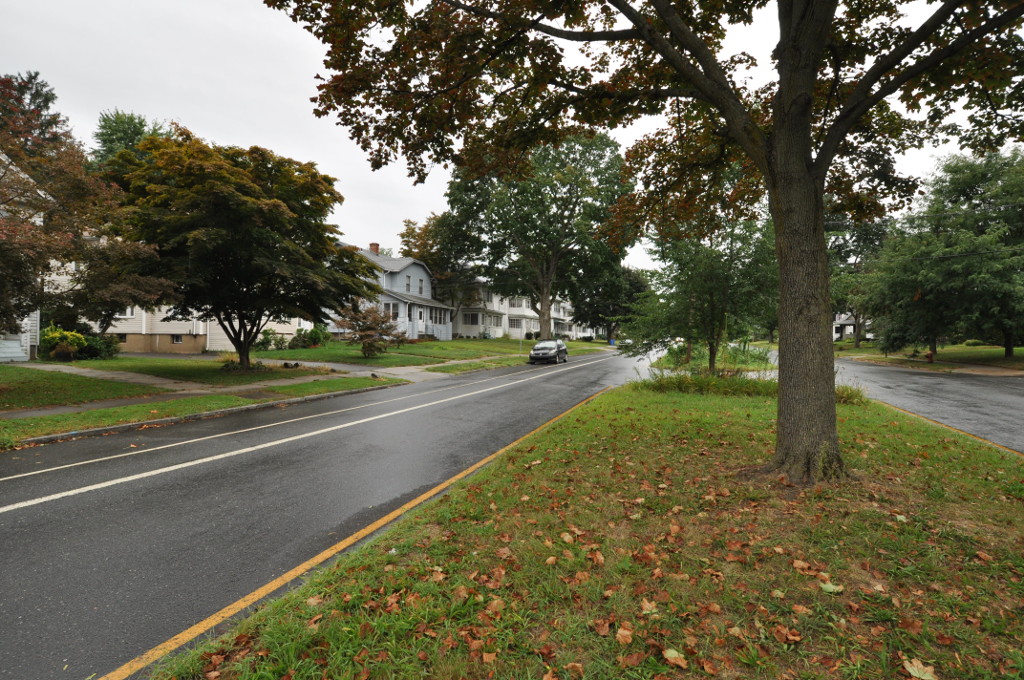
60. West End South Historic District

The West End South Historic District encompasses a neighborhood of mid 19th to early 20th century residential architecture in western Hartford, Connecticut and eastern West Hartford, Connecticut. Roughly bounded by Prospect and South Whitney Streets, West Boulevard, and Farmington Avenue, the area includes a large number of Colonial Revival and Queen Anne houses, as well as numerous buildings in other period styles, with only a small number of losses. It was listed on the National Register of Historic Places in 1985.
Wikipedia: West End South Historic District (EN), Heritage Website
61. Footguard Hall

Footguard Hall was the headquarters and armory of the First Company Governor's Footguard of the state Connecticut, a ceremonial military company founded in 1771 and originally tasked with protecting the governor and state legislature. The hall is located at 159 High Street, in Hartford, Connecticut, in a Romanesque Revival brick building built in 1888. The building was listed on the National Register of Historic Places in 1984 in recognition of the organization's history and its distinctive architecture. The First Company Governor's Footguard now uses the Governor William A. O'Neill State Armory at 360 Broad Street, Hartford, Connecticut.
62. Collins and Townley Streets Historic District

The Collins and Townley Streets District is a historic district encompassing a cluster of mid-to-late 19th-century residences in the Asylum Hill neighborhood of Hartford, Connecticut. It includes properties on Collins, Atwood, Willard, and Townley Streets, which range architecturally from the Italianate and Second Empire of the 1860s and 1870s to the Shingle style of the 1890s. The district was listed on the National Register of Historic Places in 1979.
Wikipedia: Collins and Townley Streets District (EN), Heritage Website
63. Oxford–Whitney Streets Historic District
The Oxford-Whitney Streets District is a historic district encompassing an early-20th century residential area in the West End neighborhood of Hartford, the capital city of the U.S. state of Connecticut. It extends along the east side of Oxford Street between Elizabeth and Cone Streets, and along the west side of Whitney between Fern and Elizabeth, and includes the north side of Fern Street between Whitney and Oxford. Most of the housing, a combination of single and multi-family residences, was built between 1906 and 1919, a period later than the surrounding areas, and is predominantly Colonial Revival in character. It was listed on the National Register of Historic Places in 2010.
Wikipedia: Oxford-Whitney Streets Historic District (EN), Heritage Website
64. Charter Oak Place

Charter Oak Place is a street on the south side of downtown Hartford, Connecticut. Laid out in the 1860s, its residential character is in marked contrast to the commercial development that predominates around it. The street's buildings, constructed between the early 1860s and 1900, are a cross-section of Victorian architectural styles. The entire length of the street is listed on the National Register of Historic Places.
65. Keney Tower
Keney Tower is a memorial tower located in a small public park at Main and Ely Streets north of downtown Hartford, Connecticut. Built in 1898 as a memorial to family members by the locally prominent Keney family, it is a distinctive local example of Collegiate Gothic architecture, and is the city's only free-standing tower. It was listed on the National Register of Historic Places in 1978.
66. Laurel and Marshall Streets District

The Laurel and Marshall Streets District is a historic district encompassing a late-19th and early-20th century residential area in the Asylum Hill neighborhood of Hartford, Connecticut. Extending along Laurel and Marshall Streets between Niles and Case Streets, its housing stock represents a significant concentration of middle-class Queen Anne architecture in the city. It was listed on the National Register of Historic Places in 1979.
Wikipedia: Laurel and Marshall Streets District (EN), Heritage Website
67. Congress Street

Congress Street is a city street in the South Green neighborhood of Hartford, Connecticut. Extending for a single block from the South Green to Morris Street, it was developed in the 1850s with modest two-family residences, with infill development of larger apartment blocks around the turn of the 20th century. The entire street was listed on the National Register of Historic Places in 1975 as a good example of a well-preserved late-19th century residential street.
Wikipedia: Congress Street (Hartford, Connecticut) (EN), Heritage Website
68. Stackpole, Moore, and Tryon Building

The Stackpole, Moore, and Tryon Building is a historic commercial building at 105-115 Asylum Street in downtown Hartford, Connecticut. Built in the mid-19th century, and extensively altered in 1896, it is a good local example of a period building with a Beaux Arts cast-iron facade. It was listed on the National Register of Historic Places in 1978.
Wikipedia: Stackpole, Moore, and Tryon Building (EN), Heritage Website
69. West End North Historic District

The West End North Historic District encompasses a neighborhood of late 19th and early 20th century residential architecture in western Hartford, Connecticut and eastern West Hartford, Connecticut. Roughly bounded by Prospect, Elizabeth, and Lorraine Streets and Farmington Avenue, the area includes a large number of Colonial Revival and Queen Anne houses, as well as numerous buildings in other period styles, with only a small number of losses. It was listed on the National Register of Historic Places in 1985.
Wikipedia: West End North Historic District (EN), Heritage Website
70. Lewis Street Block Historic District

The Lewis Street Block is a historic district encompassing the southern half of Lewis Street and some adjacent buildings in downtown Hartford, Connecticut. The streetscape is reminiscent of a mid-19th century city street, with architecture extending from that period into the early 20th century. The district was listed on the National Register of Historic Places in 1976.
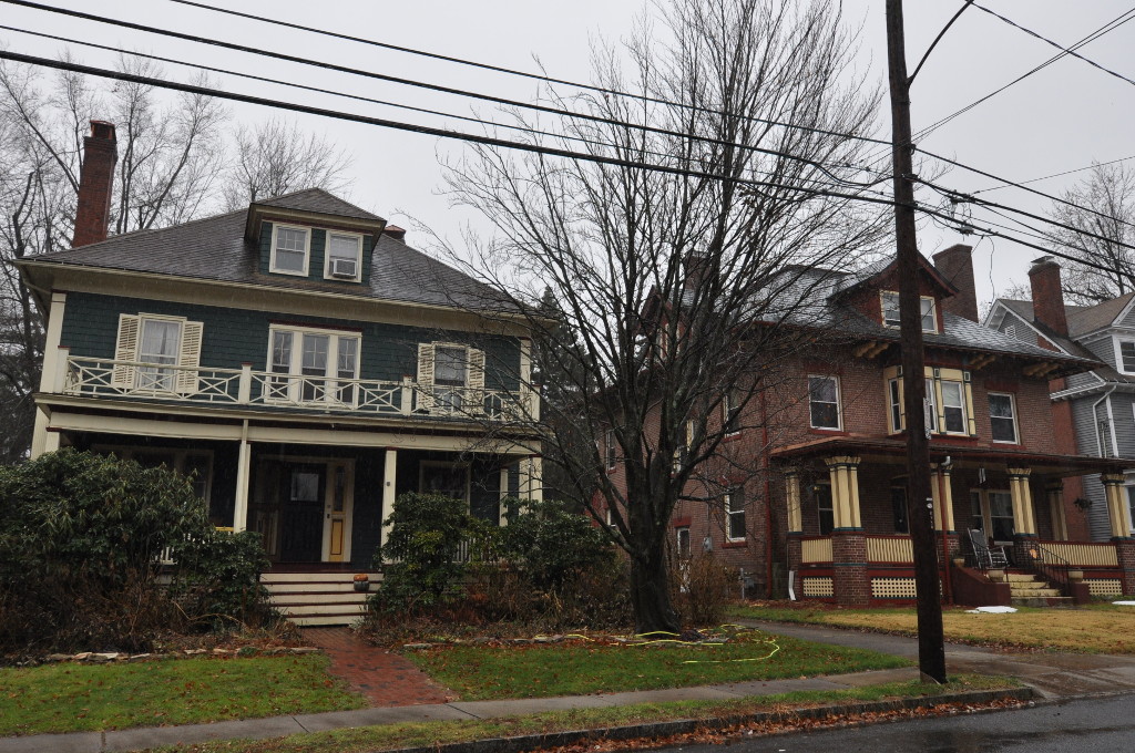
71. Sigourney Square Historic District
The Signourney Square Historic District encompasses a neighborhood in the Asylum Hill area of Hartford, Connecticut, United States, that was almost entirely built out in a single decade at the end of the 19th century as a middle-class residential area. It is roughly bounded by Garden, Ashley, and Woodland Streets on the east, south, and west, and by railroad tracks north of Sargeant Street to the north. The area retains much of its late 19th-century character, with relatively few modern intrusions. It was listed on the National Register of Historic Places in 1979, with small additions in 1983 and 2011.
72. Webster Memorial Building

The Webster Memorial Building is a historic house at 36 Trumbull Street in downtown Hartford, Connecticut. Built in 1870 and extensively restyled in 1924, it is a rare example of Georgian Revival architecture in the downtown area, noted for its historical association with the Family Services Society, a prominent local charity. The building, now in other commercial use, was listed on the National Register of Historic Places in 1982.
73. Underwood Computing Machine Company Factory

The Underwood Computing Machine Company Factory is a historic industrial complex at 56 Arbor Street in the Parkville neighborhood of Hartford, Connecticut. Developed beginning in 1917 by the Underwood Typewriter Company, it was used by that company and its successors for manufacturing, research, and development until 1969. It presently houses the artistic collaborative Real Art Ways and other organizations. The complex was listed on the National Register of Historic Places in 1989.
Wikipedia: Underwood Computing Machine Company Factory (EN), Heritage Website
74. First National Bank Building

The First National Bank Building is a historic commercial building at 50-58 State House Square in the heart of downtown Hartford, Connecticut. Built in 1899, it is a fine local example of Beaux Arts architecture, and was one of the first of Hartford's commercial buildings to have a steel frame. It was listed on the National Register of Historic Places in 1984.
Wikipedia: First National Bank Building (Hartford, Connecticut) (EN), Heritage Website
75. Stone Bridge

The Stone Bridge is a historic bridge in Hartford, Connecticut, carrying Main Street across the Whitehead Highway just south of the city's downtown. Built in 1833 across the Park River, it was the largest single-span stone bridge in the United States at its completion. It was listed on the National Register of Historic Places in 1985.
Wikipedia: Stone Bridge (Hartford, Connecticut) (EN), Heritage Website
76. Widows' Home

The Widows' Home is a historic social service facility at 1846-1860 North Main Street in Hartford, Connecticut. Built in 1864–65, its buildings are among the oldest in the city's North End, and a rare surviving example of a mid-19th-century facility for indigent women. It was listed on the National Register of Historic Places in 1983. The buildings have been adapted to other uses.
77. Grandview Terrace Boulevard Historic District

Grandview Terrace Boulevard is a historic district encompassing a small well-preserved early 20th-century neighborhood in Hartford, Connecticut. It extends along Grandview Terrace in southwestern Hartford, between White and Linnmoore Streets, and includes a series of high-quality homes built mainly between 1910 and 1925. It was listed on the National Register of Historic Places in 2002.
Wikipedia: Grandview Terrace Boulevard (EN), Heritage Website
78. West Boulevard Historic District
The West Boulevard Historic District encompasses a historic residential development on West Boulevard and Rodney Street in the West End of Hartford, Connecticut. The area was developed beginning in 1909, and most of its homes were built by a single construction firm, creating a neighborhood appearance unified by style, scale, and setting, using the principles of the then-fashionable City Beautiful movement. The district was listed on the National Register of Historic Places in 2007.
Wikipedia: West Boulevard Historic District (EN), Heritage Website
79. Sisson–South Whitney Historic District

The Sisson-South Whitney Historic District encompasses a neighborhood in the West End area of Hartford, Connecticut, that was built out between 1890 and 1930 as a streetcar suburb. It is roughly bounded by Farmington Avenue, South Whitney Street, West Boulevard, and Sisson Avenue, and includes a diversity of residential and commercial architecture, reflective of its initial development and subsequent growth. The district was listed on the National Register of Historic Places in 2013.
Wikipedia: Sisson-South Whitney Historic District (EN), Heritage Website
80. Old North Cemetery

The Old North Cemetery is a cemetery on Main Street in the Clay-Arsenal neighborhood north of downtown Hartford, Connecticut. It was established in 1807, and was the city's second municipal cemetery. It was the principal burying ground for the city's elites for many years, and has a fine collection of 19th-century funerary art. It was listed on the National Register of Historic Places in 1998. Although burials continue to take place there occasionally, they only take place on existing plots.
Wikipedia: Old North Cemetery (Hartford, Connecticut) (EN), Heritage Website
81. Vine Street Apartment Buildings

The Vine Street Apartment Buildings, many now known as the Horace Bushnell Apartments, are a historic collection of residential apartment blocks at 4-48 Vine Street in Hartford, Connecticut. Built between 1922 and 1925, they consist of eleven brick buildings sharing massing, scale, and setting, with a cross-section of period building styles. They were listed on the National Register of Historic Places in 2012.
Wikipedia: Vine Street Apartment Buildings (EN), Heritage Website
82. South Green Historic District

The South Green Historic District encompasses a predominantly 19th-century residential area near the South Green of Hartford, Connecticut. This area features a variety of residences in both high and common styles, from the elaborate home of armsmaker Samuel Colt to multi-unit apartment houses, many of which were built between about 1860 and 1900. The district is roughly triangular, extending from South Green along Main Street and Wethersfield Avenue to include Morris, Dean, and Alden Streets. The district was listed on the National Register of Historic Places in 1977.
Wikipedia: South Green Historic District (Hartford, Connecticut) (EN), Heritage Website
Share
How likely are you to recommend us?
Disclaimer Please be aware of your surroundings and do not enter private property. We are not liable for any damages that occur during the tours.