100 Sights in Boston, United States (with Map and Images)
Legend
Premium Sights
Book tickets, guided tours and activities in Boston.
Guided Free Walking Tours
Book free guided walking tours in Boston.
Welcome to your journey through the most beautiful sights in Boston, United States! Whether you want to discover the city's historical treasures or experience its modern highlights, you'll find everything your heart desires here. Be inspired by our selection and plan your unforgettable adventure in Boston. Dive into the diversity of this fascinating city and discover everything it has to offer.
Sightseeing Tours in BostonActivities in Boston
USS Constitution, also known as Old Ironsides, is a three-masted wooden-hulled heavy frigate of the United States Navy. She is the world's oldest commissioned naval warship still afloat. She was launched in 1797, one of six original frigates authorized for construction by the Naval Act of 1794 and the third constructed. The name "Constitution" was among ten names submitted to President George Washington by Secretary of War Timothy Pickering in March of 1795 for the frigates that were to be constructed. Joshua Humphreys designed the frigates to be the young Navy's capital ships, and so Constitution and her sister ships were larger and more heavily armed and built than standard frigates of the period. She was built at Edmund Hartt's shipyard in the North End of Boston, Massachusetts. Her first duties were to provide protection for American merchant shipping during the Quasi-War with France and to defeat the Barbary pirates in the First Barbary War.
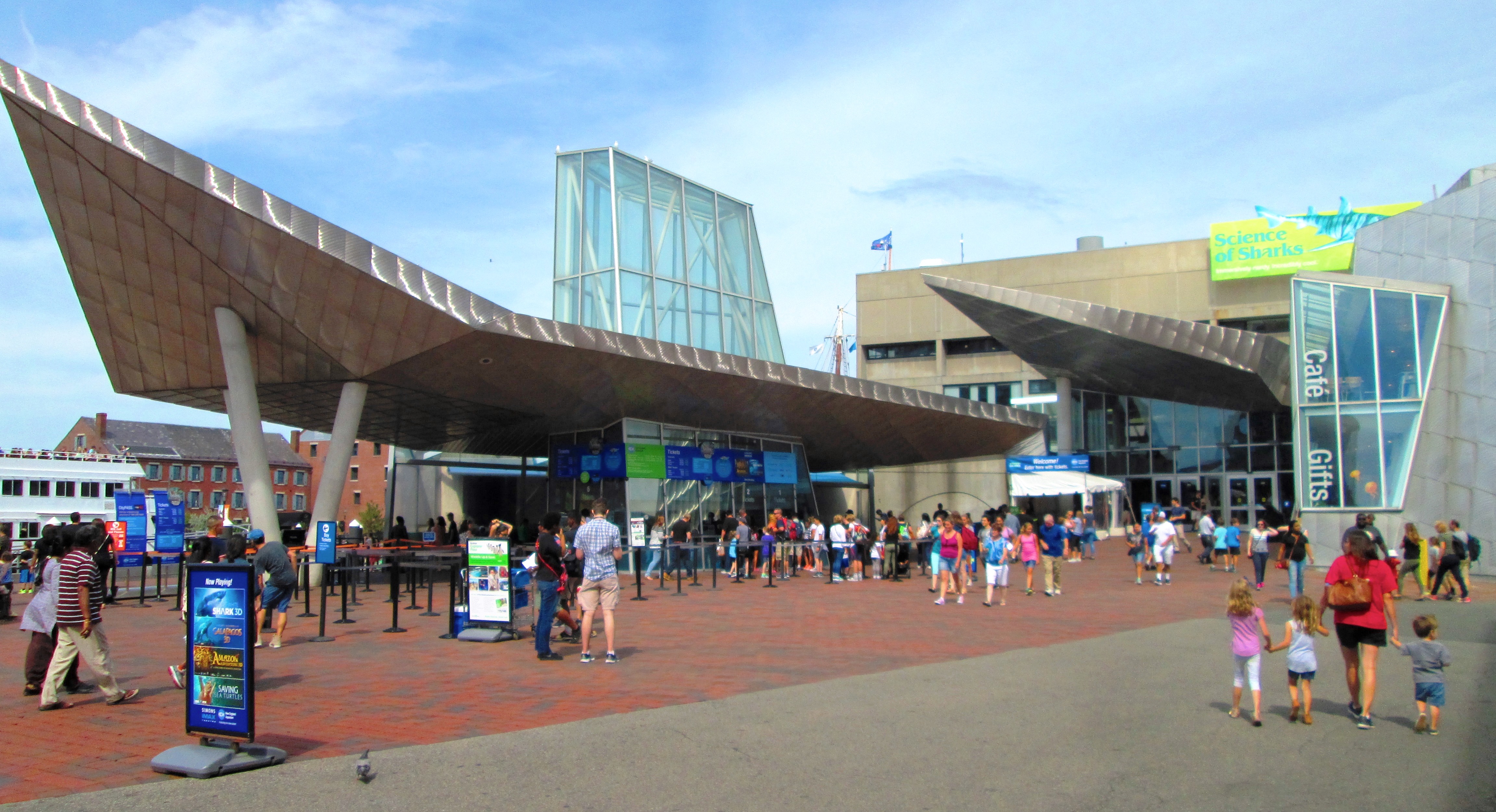
The New England Aquarium is a nonprofit organization located in Boston, Massachusetts. The species exhibited include harbor and northern fur seals, California sea lions, African and southern rockhopper penguins, giant Pacific octopuses, weedy seadragons, and thousands of saltwater and freshwater fishes. In addition to the main aquarium building, attractions at Central Wharf include the Simons Theatre and the New England Aquarium Whale Watch. More than 1.3 million guests visited the aquarium each year prior to the outbreak of the COVID-19 pandemic.

King's Chapel is an American independent Christian unitarian congregation affiliated with the Unitarian Universalist Association that is "unitarian Christian in theology, Anglican in worship, and congregational in governance." It is housed in what was for a time after the Revolution called the "Stone Chapel", an 18th-century structure at the corner of Tremont Street and School Street in Boston, Massachusetts. The chapel building, completed in 1754, is one of the finest designs of the noted colonial architect Peter Harrison, and was designated a National Historic Landmark in 1960 for its architectural significance. The congregation has worshipped according to a Unitarian version of the Book of Common Prayer since 1785, currently in its ninth edition.

The Paul Revere House, built c.1680, was the colonial home of American Patriot and Founding Father Paul Revere during the time of the American Revolution. A National Historic Landmark since 1961, it is located at 19 North Square, Boston, Massachusetts, in the city's North End, and is now operated as a nonprofit museum by the Paul Revere Memorial Association. An admission fee is charged.

TD Garden is a multi-purpose arena in Boston, Massachusetts, United States. It is located directly above the MBTA's North Station, and replaced the original Boston Garden upon opening in 1995. It is the most visited sports and entertainment arena in New England, as nearly 3.5 million people visit the arena each year.

Park Street Congregational Church, founded in 1809, is a historic and active evangelical congregational church in Downtown Boston, Massachusetts, United States. The Park Street Church is a member of the Conservative Congregational Christian Conference. Church membership records are private, but the congregation has over 1,200 members. The church is located at 1 Park Street, at the corner of Tremont Street.

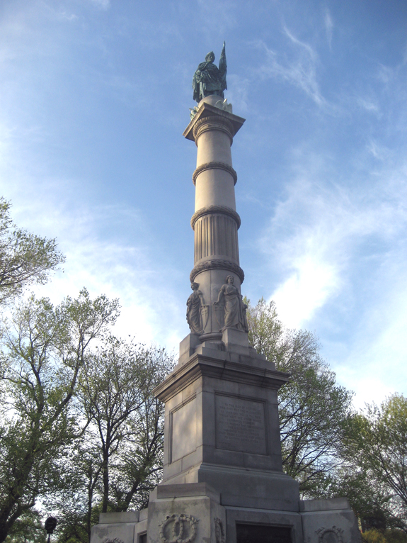
The Bunker Hill Monument is a monument erected at the site of the Battle of Bunker Hill in Boston, Massachusetts, which was among the first major battles between the United Colonies and the British Empire in the American Revolutionary War. The 221-foot granite obelisk was erected between 1825 and 1843 in Charlestown, Massachusetts, with granite from nearby Quincy conveyed to the site via the purpose-built Granite Railway, followed by a trip by barge. There are 294 steps to the top.

The Old North Church, is an Episcopal mission church located in the North End neighborhood of Boston. The church, which was built in 1723, is the oldest standing church building in Boston and a National Historic Landmark.

The Granary Burying Ground in Massachusetts is the city of Boston's third-oldest cemetery, founded in 1660 and located on Tremont Street. It is the burial location of Revolutionary War-era patriots, including Paul Revere, the five victims of the Boston Massacre, and three signers of the Declaration of Independence: Samuel Adams, John Hancock, and Robert Treat Paine. The cemetery has 2,345 grave-markers, but historians estimate that as many as 5,000 people are buried in it. The cemetery is adjacent to Park Street Church, behind the Boston Athenæum and immediately across from Suffolk University Law School. It is a site on Boston's Freedom Trail. The cemetery's Egyptian revival gate and fence were designed by architect Isaiah Rogers (1800–1869), who designed an identical gate for Newport's Touro Cemetery.

Quincy Market is a historic building near Faneuil Hall in downtown Boston, Massachusetts. It was constructed between 1824 and 1826 and named in honor of mayor Josiah Quincy, who organized its construction without any tax or debt. The market is a designated National Historic Landmark and a designated Boston Landmark in 1996, significant as one of the largest market complexes built in the United States in the first half of the 19th century. According to the National Park Service, some of Boston's early slave auctions took place near what is now Quincy Market.
11. Faneuil Hall

Faneuil Hall is a marketplace and meeting hall located near the waterfront and today's Government Center, in Boston, Massachusetts. Opened in 1742, it was the site of several speeches by Samuel Adams, James Otis, and others encouraging independence from Great Britain. It is now part of Boston National Historical Park and a well-known stop on the Freedom Trail. It is sometimes referred to as "the Cradle of Liberty", though the building and location have ties to slavery.
12. Clef Sculpture

A clef is a musical symbol used to indicate which notes are represented by the lines and spaces on a musical staff. Placing a clef on a staff assigns a particular pitch to one of the five lines or four spaces, which defines the pitches on the remaining lines and spaces.
13. Boston Marathon Finish Line
The Boston Marathon is an annual marathon race hosted by several cities and towns in greater Boston in eastern Massachusetts, United States. It is traditionally held on Patriots' Day, the third Monday of April. Begun in 1897, the event was inspired by the success of the first marathon competition in the 1896 Summer Olympics. The Boston Marathon is the world's oldest annual marathon and ranks as one of the world's best-known road racing events. It is one of seven World Marathon Majors. Its course runs from Hopkinton in southern Middlesex County to Copley Square in Boston.
14. Michael S. Dukakis South Station Transportation Center

South Station, officially The Governor Michael S. Dukakis Transportation Center at South Station, is the largest railroad station and intercity bus terminal in Greater Boston and New England's second-largest transportation center after Logan International Airport. Located at the intersection of Atlantic Avenue and Summer Street in Dewey Square, Boston, Massachusetts, the historic station building was constructed in 1899 to replace the downtown terminals of several railroads. Today, it serves as a major intermodal domestic transportation hub, with service to the Greater Boston region and the Northeastern and Midwestern United States. It is used by thousands of commuter rail and intercity rail passengers daily. Connections to the rapid transit Red Line and bus rapid transit Silver Line are made through the adjacent subway station.
15. Chinatown Gate
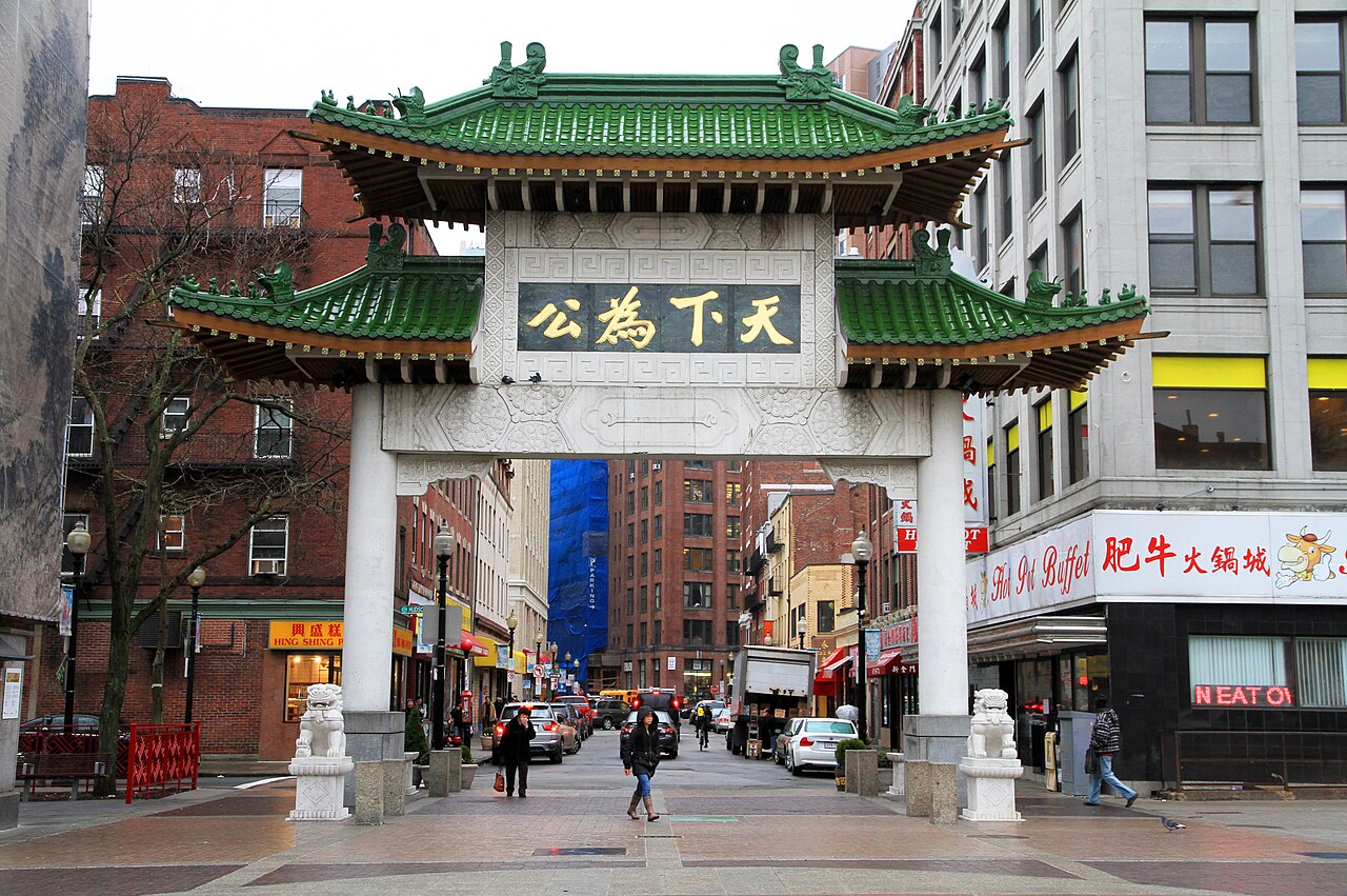
Chinatown, Boston is a neighborhood located in downtown Boston, Massachusetts, United States. It is the only surviving historic ethnic Chinese enclave in New England since the demise of the Chinatowns in Providence, Rhode Island and Portland, Maine after the 1950s. Because of the high population of Asians and Asian Americans living in this area of Boston, there is an abundance of Chinese and Vietnamese restaurants located in Chinatown. It is one of the most densely populated residential areas in Boston and serves as the largest center of its East Asian and Southeast Asian cultural life.
16. John F. Kennedy Presidential Library and Museum

The John F. Kennedy Presidential Library and Museum is the presidential library and museum of John Fitzgerald Kennedy (1917–1963), the 35th president of the United States (1961–1963). It is located on Columbia Point in the Dorchester neighborhood of Boston, Massachusetts, next to the University of Massachusetts at Boston, the Edward M. Kennedy Institute for the United States Senate, and the Massachusetts Archives and Commonwealth Museum. Designed by the architect I. M. Pei, the building is the official repository for original papers and correspondence of the Kennedy Administration, as well as special bodies of published and unpublished materials, such as books and papers by and about Ernest Hemingway.
Wikipedia: John F. Kennedy Presidential Library and Museum (EN), Website
17. Ancient and Honorable Artillery Company Museum

The Ancient and Honorable Artillery Company of Massachusetts is the oldest chartered military organization in North America and the third oldest chartered military organization in the world. A volunteer militia of the Commonwealth of Massachusetts, it is not part of the U.S. Armed Forces, but includes veterans and serving military members within its ranks.
Wikipedia: Ancient and Honorable Artillery Company of Massachusetts (EN), Website
18. Boston Public Garden

The Public Garden, also known as Boston Public Garden, is a large park in the heart of Boston, Massachusetts, adjacent to Boston Common. It is a part of the Emerald Necklace system of parks and is bounded by Charles Street and Boston Common to the east, Beacon Street and Beacon Hill to the north, Arlington Street and Back Bay to the west, and Boylston Street to the south. The Public Garden was the first public botanical garden in America.
19. USS Cassin Young

USS Cassin Young (DD-793) is a Fletcher-class destroyer of the United States Navy named for Captain Cassin Young (1894–1942), who was awarded the Medal of Honor for his heroism at the Japanese attack on Pearl Harbor and killed in the Naval Battle of Guadalcanal in the fall of 1942.
20. Old South Meeting Place

The Old South Meeting House is a historic Congregational church building located at the corner of Milk and Washington Streets in the Downtown Crossing area of Boston, Massachusetts, built in 1729. It gained fame as the organizing point for the Boston Tea Party on December 16, 1773. Five thousand or more colonists gathered at the Meeting House, the largest building in Boston at the time.
21. Ether Dome

The Ether Dome is a surgical operating amphitheater in the Bulfinch Building at Massachusetts General Hospital in Boston, United States. It served as the hospital's operating room from its opening in 1821 until 1867. It was the site of the first public demonstration of the use of inhaled ether as a surgical anesthetic on October 16, 1846, otherwise known as Ether Day. Crawford Long, a surgeon in Georgia, had previously administered sulfuric ether in 1842, but this went unpublished until 1849. The Ether Dome event occurred when William Thomas Green Morton, a local dentist, used ether to anesthetize Edward Gilbert Abbott. John Collins Warren, the first dean of Harvard Medical School, then painlessly removed part of a tumor from Abbott's neck. After Warren had finished, and Abbott regained consciousness, Warren asked the patient how he felt. Reportedly, Abbott said, "Feels as if my neck's been scratched". Warren then turned to his medical audience and uttered "Gentlemen, this is no Humbug". This was presumably a reference to the unsuccessful demonstration of nitrous oxide anesthesia by Horace Wells in the same theater the previous year, which was ended by cries of "Humbug!" after the patient groaned with pain.
22. First Church of Christ Scientist

The First Church of Christ, Scientist is the administrative headquarters and mother church of the Church of Christ, Scientist, also known as the Christian Science church. Christian Science was founded in the 19th century in Lynn, Massachusetts, by Mary Baker Eddy with the publication of her book Science and Health (1875).
23. Commonwealth Ave Mall

Commonwealth Avenue is a major street in the cities of Boston and Newton, Massachusetts. It begins at the western edge of the Boston Public Garden, and continues west through the neighborhoods of the Back Bay, Kenmore Square, Boston University, Allston, Brighton and Chestnut Hill. It continues as part of Route 30 through Newton until it crosses the Charles River at the border of the town of Weston.
24. Basilica of Our Lady of Perpetual Hope

The Basilica and Shrine of Our Lady of Perpetual Help informally known as The Mission Church is a Roman Catholic basilica in the Mission Hill neighborhood of Boston, Massachusetts, United States. The Redemptorists priests of the Baltimore Province have ministered to the parish since the church was first opened in 1870. The shrine is dedicated to the Blessed Virgin Mary under the title of Our Mother of Perpetual Help.
Wikipedia: Basilica and Shrine of Our Lady of Perpetual Help (EN), Website
25. Counterpoint

Arts on the Line was a program devised to bring art into the Massachusetts Bay Transportation Authority (MBTA) subway stations in the late 1970s and early 1980s. Arts on the Line was the first program of its kind in the United States and became the model for similar drives for art across the country. The first twenty artworks were completed in 1985 with a total cost of US$695,000, or one half of one percent of the total construction cost of the Red Line Northwest Extension, of which they were a part.
26. The Institute of Contemporary Art
The Institute of Contemporary Art (ICA) is an art museum and exhibition space located in Boston, Massachusetts, United States. The museum was founded as the Boston Museum of Modern Art in 1936. Since then it has gone through multiple name changes as well as moving its galleries and support spaces over 13 times. Its current home was built in 2006 in the South Boston Seaport District and designed by architects Diller Scofidio + Renfro.
Wikipedia: Institute of Contemporary Art, Boston (EN), Website
27. Boston Light
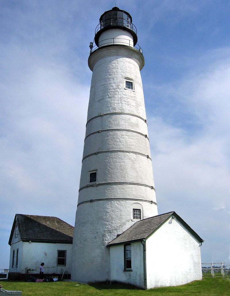
Boston Light is a lighthouse located on Little Brewster Island in outer Boston Harbor, Massachusetts. The first lighthouse to be built on the site dates back to 1716, and was the first lighthouse to be built in what is now the United States. The current lighthouse dates from 1783. It is the second oldest working lighthouse in the United States and is the only lighthouse to still be actively staffed by the United States Coast Guard despite its automation in 1998. The structure was designated a National Historic Landmark in 1964.
28. African Meeting House

The African Meeting House, also known variously as First African Baptist Church, First Independent Baptist Church and the Belknap Street Church, was built in 1806 and is now the oldest black church edifice still standing in the United States. A Baptist congregation led by Reverend Thomas Paul built the church. The church also established a school, at first holding classes in its basement. After serving most of the nineteenth century as a church, it then served as a synagogue until 1972 when it was purchased for the Museum of African American History. It is located in the Beacon Hill neighborhood of Boston, Massachusetts, adjacent to the historically Black American Abiel Smith School, now also part of the museum. It is a National Historic Landmark.
29. Hood Milk Bottle
HP Hood LLC is an American dairy company based in Lynnfield, Massachusetts. Hood was founded in 1846 in Derry, New Hampshire, by Harvey Perley Hood. After two years in Derry, Hood took his milk south and established a factory in Charlestown, Massachusetts. Recent company acquisitions by HP Hood have expanded its reach from predominantly New England to the broader United States. Today, the company has an annual sales revenue of about $3.2 billion and more than 3,400 employees.
30. John Fitzgerald Kennedy National Historic Site

The John Fitzgerald Kennedy National Historic Site is the birthplace and childhood home of John F. Kennedy, the 35th president of the United States. The house is at 83 Beals Street in the Coolidge Corner neighborhood of Brookline, Massachusetts. Kennedy is one of four U.S. presidents born in Norfolk County, Massachusetts. The property is now owned by the National Park Service; tours of the house are offered, and a film is presented.
Wikipedia: John Fitzgerald Kennedy National Historic Site (EN), Website
31. Georges Island
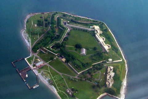
Georges Island is one of the islands in the Boston Harbor, situated just over 7 miles (11 km) from downtown Boston. The island has a permanent size of 39 acres (160,000 m2), plus an intertidal zone of a further 14 acres (57,000 m2), and rises to a height of 50 feet (15 m) above sea level. Historic Fort Warren is on the island. Because of this, and since a ferry operates from Boston to the island, it is a popular destination and one of the easiest islands to access in the Boston Harbor Islands National Recreation Area.
32. Statler Park

The Hilton Boston Park Plaza is a historic hotel in Boston, Massachusetts, United States, opened on March 10, 1927. It was built by hotelier E.M. Statler as part of his Statler Hotels chain. A prototype of the grand American hotel, it was called a "city within a city" and also contains an adjoining office building. It was the first hotel in the world to offer in-room radio in every room.
33. Battery Wharf

Boston Harborwalk is a public walkway that follows the edge of piers, wharves, beaches, and shoreline around Boston Harbor. When fully completed it will extend a distance of 47 miles (76 km) from East Boston to the Neponset River.
34. Arlington Street Church

The Arlington Street Church is a Unitarian Universalist church across from the Public Garden in Boston, Massachusetts. Because of its geographic prominence and the notable ministers who have served the congregation, the church is considered to be among the most historically important in American Unitarianism and Unitarian Universalism. Completed in 1861, it was designed by Arthur Gilman and Gridley James Fox Bryant to resemble James Gibbs' St. Martin-in-the-Fields in London. The main sanctuary space has 16 large-scale stained-glass windows installed by Tiffany Studios from 1899 to 1930.
35. The Embrace

The Embrace is a bronze sculpture by Hank Willis Thomas, installed on Boston Common in Boston, Massachusetts, United States, in December 2022. The artwork commemorates Martin Luther King Jr. and Coretta Scott King, and depicts four intertwined arms, representing the hug they shared after he was awarded the Nobel Peace Prize in 1964. The work was created by welding together about 609 smaller pieces. The sculpture has received largely negative responses from critics and the public.
36. Jordan Hall

Jordan Hall is a 1,051-seat concert hall in Boston, Massachusetts, the principal performance space of the New England Conservatory. It is one block from Boston's Symphony Hall. It is the only conservatory building in the United States to be designated a National Historic Landmark. This building is currently under study by the Boston Landmarks Commission for landmark status.
37. Boston National Historical Park

The Boston National Historical Park is an association of sites that showcase Boston's role in the American Revolution and other parts of history. It was designated a national park on October 1, 1974. Seven of the eight sites are connected by the Freedom Trail, a walking tour of downtown Boston. All eight properties are National Historic Landmarks.
38. Skinny House

The Skinny House is an extremely narrow four-story house at 44 Hull Street in the North End of Boston, Massachusetts, United States. It is reported by the Boston Globe as having the "uncontested distinction of being the narrowest house in Boston." According to the executive director of the Boston Landmarks Commission, "In a city where there are many narrow lots, this far exceeds the norm. ... As far as we know, it is the narrowest house in Boston." According to local legend, it was built as a spite house.
39. Marsh Chapel

Marsh Chapel is a building on the campus of Boston University used as the official place of worship of the school. It was named for Daniel L. Marsh, a former president of BU and a Methodist minister. The building is Gothic in style.
40. First Church in Boston

First Church in Boston is a Unitarian Universalist Church founded in 1630 by John Winthrop's original Puritan settlement in Boston, Massachusetts. The current building, located on 66 Marlborough Street in the Back Bay neighborhood, was designed by Paul Rudolph in a modernist style after a fire in 1968. It incorporates part of the earlier gothic revival building designed by William Robert Ware and Henry Van Brunt in 1867. The church has long been associated with Harvard University.
41. Old City Hall

Boston's Old City Hall was home to its city council from 1865 to 1969. It was one of the first buildings in the French Second Empire style to be built in the United States. After the building's completion, the Second Empire style was used extensively elsewhere in Boston and for many public buildings in the United States, including the Eisenhower Executive Office Building in Washington, D.C., Providence City Hall in Providence, Baltimore City Hall in Baltimore, and Philadelphia City Hall in Philadelphia. The building's architects were Gridley James Fox Bryant and Arthur Gilman.
42. Norman B. Leventhal Park

Post Office Square in Boston, Massachusetts, is a square located in the financial district at the intersection of Milk, Congress, Pearl and Water Streets. It was named in 1874 after the United States Post Office and Sub-Treasury which fronted it, now replaced by the John W. McCormack Post Office and Courthouse.
43. Boston Opera House

The Boston Opera House, also known as the Citizens Bank Opera House, is a performing arts and esports venue located at 539 Washington St. in Boston, Massachusetts. It was originally built as the B.F. Keith Memorial Theatre, a movie palace in the Keith-Albee chain. The chain became part of RKO when it was established just before the theater opened on October 29, 1928, and it was also known as the RKO Keith's Theater. After operating for more than 50 years as a movie theater, it was rededicated in 1980 as a home for the Opera Company of Boston, which performed there until the opera company closed down in 1990 due to financial problems. The theater was reopened in 2004 after a major restoration, and it currently serves as the home of the Boston Ballet and also hosts touring Broadway shows.
44. 401 Park

The Landmark Center or 401 Park Building in Boston, Massachusetts is a commercial center situated in a limestone and brick art deco building built in 1928 for Sears, Roebuck and Company. It features a 200-foot-tall (61 m) tower and, as Sears Roebuck and Company Mail Order Store, it is listed on the National Register of Historic Places and designated as a Boston Landmark in 1989.
45. Louisburg Square

Louisburg Square is a street in the Beacon Hill neighborhood of Boston, Massachusetts, bisected by a small private park. The park, which is bounded by Pinckney Street to the north and Mount Vernon Street to the south, is maintained by the Louisburg Square Proprietors. While the Proprietors pay taxes to the City of Boston, the city does not own the park or its garden.
46. Huntington Theatre Company

The Huntington Theatre Company is a professional theatre located in Boston, Massachusetts and the recipient of the 2013 Regional Theatre Tony Award, under the direction of Managing Director Michael Maso. It is notable for its longstanding artistic relationship with African-American playwright August Wilson.
47. Swan Boats

The Swan Boats are a fleet of pontoon pleasure boats which operate in a pond in the Public Garden in Boston, Massachusetts. The Swan Boats have been in operation since 1877, and have since become a cultural icon for the city. They operate beginning the second weekend of April and ending Labor Day weekend in September.
Wikipedia: Swan Boats (Boston, Massachusetts) (EN), Website, Twitter, Facebook, Instagram, Website
48. Abiel Smith School

Abiel Smith School, founded in 1835, is a school located at 46 Joy Street in Boston, Massachusetts, United States, adjacent to the African Meeting House. It is named for Abiel Smith, a white philanthropist who left money in his will to the city of Boston for the education of black children.
49. Gibson House

The Gibson House Museum is a historic house museum located at 137 Beacon Street in the Back Bay neighborhood of Boston, Massachusetts. It preserves the 1860 Victorian rowhouse occupied by three generations of the Gibson family. The house was one of the first to be built in Back Bay, and has an unparalleled state of preservation that includes wallpaper, textiles, furnishings, and family artifacts and collections. Both the public and service areas of the house exhibit a high degree of preservation, and are viewable on tours. The property was designated a Boston Landmark in 1992 by the Boston Landmarks Commission and a National Historic Landmark in 2001.
50. Soldiers and Sailors Monument
The Soldiers and Sailors Monument is a monument erected in Boston Common in downtown Boston, dedicated to soldiers and sailors of the Commonwealth of Massachusetts who died in the American Civil War. Designed by Martin Milmore, construction began in 1874 and the monument was dedicated on September 17, 1877. Union Generals George B. McClellan and Joseph Hooker were among the estimated 25,000 people attending the dedication on Boston Common.
51. The Graves Light

The Graves Light is a lighthouse located on The Graves, the outermost island of the Boston Harbor Islands National Recreation Area, and 9 miles (14 km) offshore of downtown Boston, Massachusetts, USA.
52. Old Saint Stephens Church

St. Stephen's Church is a historic church in the North End of Boston, Massachusetts. It was built in 1802–1804 as the New North Church or New North Meeting House and was designed by the noted architect Charles Bulfinch. It is the only one of the five churches he designed in Boston to remain extant. The church replaced one which had been built on the site in 1714 and enlarged in 1730. The Congregationalist church became Unitarian in 1813, and the church was sold to the Roman Catholic Diocese in 1862, and renamed St. Stephen's. It was restored and renovated in 1964-65 by Chester F. Wright, and was added to the National Register of Historic Places in 1975.
Wikipedia: St. Stephen's Church (Boston, Massachusetts) (EN), Website
53. William Hickling Prescott House
William Hickling Prescott House, also known as the Headquarters House, is an historic house museum located at 55 Beacon Street on Beacon Hill in Boston, Massachusetts. It is the left-hand portion of a double townhouse at 54–55 Beacon Street, seen in the photograph. The townhouse, built in 1808 to a design by Asher Benjamin, was designated a National Historic Landmark in 1964 for its association with William Hickling Prescott (1796–1859), one of the nation's first historians. The house is now a museum operated by the Massachusetts chapter of the National Society of the Colonial Dames of America, which purchased it for its headquarters in 1944.
54. James Blake House

The James Blake House is the oldest surviving house in Boston, Massachusetts, United States. The house was built in 1661 and the date was confirmed by dendrochronology in 2007. It is located at 735 Columbia Road, in Edward Everett Square, just a block from Massachusetts Avenue. The Dorchester Historical Society now owns the building and tours are given on the third Sunday of the month.
55. Our Lady of Good Voyage Chapel

Our Lady of Good Voyage, also known as the Seaport Shrine, is a Roman Catholic church located at 51 Seaport Boulevard in the Seaport District of Boston and in the Archdiocese of Boston. The shrine has 250 seats and holds Mass twice daily and three times on Sundays. The original chapel was located a short distance away and was built to serve the fisherman and dockworkers in what was then an industrial neighborhood.
56. Citgo Sign

The Boston Citgo sign is a large, double-faced sign featuring the logo of the oil company Citgo that overlooks Kenmore Square in Boston. The sign was installed in 1940 and updated with Citgo's present logo in 1965. The sign has become a landmark of Boston through its appearance in the background of Boston Red Sox games at Fenway Park.
57. Loring-Greenough House

The Loring–Greenough House is the last surviving 18th century residence in Sumner Hill, a historic section of Jamaica Plain, Massachusetts, a neighborhood of Boston. It is located at 12 South Street on Monument Square at the edge of Sumner Hill. It is situated on the border of two National Historic Districts.
58. The Boston Women's Memorial

The Boston Women's Memorial is a bronze and granite grouping of three figurative sculptures on the Commonwealth Avenue Mall in Boston, Massachusetts, commemorating Phillis Wheatley, Abigail Adams, and Lucy Stone.
59. Boston Young Men's Christian Union

The Boston Young Men's Christian Union is a historic building at 48 Boylston Street in Boston, Massachusetts and a liberal Protestant youth association. When Unitarians were excluded from the Boston YMCA in 1851, a group of Harvard students founded a Christian discussion group, which was incorporated as the Boston YMCU in 1852. In 1873, the organization decided to construct its own building. $270,000 was raised, and construction on the original segment completed in 1875. The building was designed by Nathaniel Jeremiah Bradlee, constructed in a High Victorian Gothic style, and included ground-level retail. Several additions were made, including in 1956. The building was designated a Boston Landmark by the Boston Landmarks Commission in 1977 and added to the National Historic Register in 1980. Boston YMCU owned Camp Union, a 600-acre (240 ha) camp, in Greenfield, New Hampshire (1929–1993). From its renovation in 2003 to 2011 it was called the Boylston Street Athletic Club, and later the Boston Union Gym or BYMCU Athletic Club. The Boston Young Men's Christian Union claims to be "America's First Gym".
60. The Guild of Boston Artists

The Guild of Boston Artists was founded in 1914 by a handful of Boston artists working in the academic and realist traditions. Among the founding members were Frank Weston Benson, William McGregor Paxton and Edmund C. Tarbell, who served as its first president through 1924. The organization holds exhibitions of its members' work several times a year as well as numerous one-person shows. Founded with the intention to promote the highest standards of quality, The Guild also hosts programs and competitions.
61. William C. Nell House

The William C. Nell House, now a private residence, was a boarding home located in 3 Smith Court in the Beacon Hill neighbourhood of Boston, Massachusetts, opposite the former African Meeting House, now the Museum of African American History.
62. Kevin W. Fitzgerald Park

Kevin W. Fitzgerald Park is a 5.5-acre (22,000 m2) neighborhood park near Brigham Circle in the Mission Hill neighborhood of Boston, Massachusetts. It was built as part of the redevelopment of the "ledge site", a former Puddingstone quarry. It is accessible from a stairway from a nearby parking lot, with a winding pathway leading upwards to a view of greater Boston.
63. Church of the Advent

The Church of the Advent is an Episcopal parish in Boston, Massachusetts, United States. The church is housed in a Victorian Gothic building, faced in brick with eight large change ringing bells and a 172-foot spire. It is well known as a prominent center of Anglo-Catholic worship.
64. Victory

The Boston Massacre Monument, also known as the Crispus Attucks Monument and Victory, is an outdoor bronze memorial by Adolph Robert Kraus, installed in Boston Common, in Boston, Massachusetts, United States.
65. Bedford Building

The Bedford Block is an historic commercial building at 99 Bedford Street Boston, Massachusetts, in an area called Church Green. Built in 1875 in a style promoted by John Ruskin called Venetian Gothic. The style may also be referred to as Ruskinian Gothic.
66. Arabic Jumaa Mosque

Allston Congregational Church is a historic Congregational church building at 31-41 Quint Avenue in the Allston neighborhood Boston, Massachusetts. Built in 1890–91 to a design by Allston native Eugene L. Clark, it is a prominent local example of Richardsonian Romanesque architecture. The property includes a Shingle style parsonage built about the same time. The buildings were listed on the National Register of Historic Places in 1997. The building presently houses a mosque and the Palestinian Cultural Center for Peace.
67. Harriet Tubman Memorial

The Harriet Tubman Memorial, also known as Step on Board, is located in Harriet Tubman Park in the South End neighborhood of Boston, Massachusetts. It honours the life of abolitionist Harriet Tubman. It was the first memorial erected in Boston to a woman on city-owned property.
68. Co|So: Copley Society of Art

The Copley Society of Art is America's oldest non-profit art association. It was founded in 1879 by the first graduating class of the School of the Museum of Fine Arts and continues to play an important role in promoting its member artists and the visual arts in Boston. The Society is named after the renowned John Singleton Copley. The gallery currently represents over 400 living artist members, ranging in experience from students to nationally recognized artists and in style from traditional and academic realists to contemporary and abstract painters, photographers, sculptors, and printmakers. Several of the artists working in the tradition of the Boston School of painters exhibit at the Copley Society of Art, along with the Guild Of Boston Artists a few doors down from the Copley Society of Art's Newbury Street location.
69. Chestnut Hill Reservation

Chestnut Hill Reservation is a public recreation area and historic preserve surrounding the Chestnut Hill Reservoir in the Chestnut Hill and Brighton neighborhoods of Boston, Massachusetts, United States. The reserve is part of the Chestnut Hill Reservoir Historic District, is listed on the National Register of Historic Places, and is a City of Boston Landmark. It is managed by the Department of Conservation and Recreation.
70. MGM Music Hall

The MGM Music Hall at Fenway is a 5,009-capacity music venue located to the direct northeast of Fenway Park in Boston, Massachusetts. Boston mayor Michelle Wu held the venue's ribbon-cutting ceremony on August 22, 2022, followed by a short private concert by Guster for the students of Tufts University. The venue's first public concert was performed by Massachusetts-bred rock band Godsmack on August 27. The venue is owned by Fenway Sports Group and operated by Live Nation Entertainment.
Wikipedia: MGM Music Hall at Fenway (EN), Website, Twitter, Facebook, Instagram, Facebook, Twitter
71. Edward Everett Square

Edward Everett Square, in Dorchester, Boston, is the intersection of Columbia Road, Massachusetts Avenue, East Cottage Street and Boston Street, that was named in 1894 after a former governor of Massachusetts, Edward Everett, who was born near there.
72. Parkman Bandstand

The Parkman Bandstand is a landmark bandstand located on the eastern side of the Boston Common in Boston, Massachusetts, United States. It was built in 1912 from a design by Derby, Robinson & Shephard at a cost of $1 million on the site of the Cow Pond, which had been filled in 1838 after cattle-grazing had been outlawed on the Common.
73. First Church in Jamaica Plain Unitarian Universalist

The First Church of Jamaica Plain is a historic church at 6 Eliot Street in the Jamaica Plain neighborhood of Boston, Massachusetts. The stone Gothic Revival church was designed in 1854 by the well known Boston architect, Nathaniel J. Bradlee, for a congregation which was established in 1769 as the Third Church of Roxbury. It is built out of ashlar granite, laid in courses without ornament. It has a square tower with Gothic arched windows at the second level, a clock face at the third, and Gothic louvered openings at the belfry, and a parapeted top. A Shingle style parish hall was added in 1889. This new addition was designed by Cabot, Everett & Mead.
74. Charles Sumner

The statue of Charles Sumner in Boston's Public Garden is a bronze statue by Thomas Ball, commissioned by the Boston Art Committee to honor Sumner after his death in 1874. The statue was dedicated in 1878.
75. Boylston Building

The Boylston Building is an historic building at 2–22 Boylston Street in Boston, Massachusetts. The six-story sandstone building was designed by Carl Fehmer and built in 1887 by Woodbury & Leighton. It is an early instance in Boston of a skeleton-built commercial structure, rather than having load-bearing masonry walls. The building housed the Boylston Market, a wholesale trading exchange which had been on the site since 1810.
76. The Tortoise and the Hare

The Tortoise and the Hare is a 1994 bronze sculpture by Nancy Schön, installed in Boston's Copley Square, in the U.S. state of Massachusetts. The work references one of Aesop's Fables, The Tortoise and the Hare, and commemorates Boston Marathon participants.
Wikipedia: The Tortoise and the Hare (sculpture) (EN), Website
77. Francis Parkman House

The Francis Parkman House is a National Historic Landmark at 50 Chestnut Street, on Beacon Hill in Boston, Massachusetts. Speculated to be designed by Cornelius Coolidge and built in 1824, it is one of a series of fine brick townhouses on Beacon Hill. Its significance lies in its ownership and occupancy by noted historian and horticulturalist Francis Parkman (1823–1893) from 1865 until his death. While living here, Parkman produced a significant portion of his landmark work, France and England in North America, a multi-volume epic history recounting the conflict for control of North America in the 17th and 18th centuries.
78. Martin's Park

The Martin W. Richard Charitable Foundation is a 501(c)(3) tax-exempt charitable foundation established by the parents of Martin Richard, an 8-year-old boy who was killed in the Boston Marathon bombing on April 15, 2013. The foundation is dedicated to promoting education and sports in the community.
79. 5 Post Office Square

The John W. McCormack Post Office and Courthouse, formerly the United States Post Office, Courthouse, and Federal Building, is a historic building at 5 Post Office Square in Boston, Massachusetts. The twenty-two-story, 331-foot (101 m) skyscraper was built between 1931 and 1933 to house federal courts, offices, and post office facilities. The Art Deco and Moderne structure was designed in a collaboration between the Supervising Architect of the United States Treasury Department and the Boston architectural firm of Cram and Ferguson. It occupies a city block bounded by Congress, Devonshire, Water, and Milk Streets, and has over 600,000 square feet (56,000 m2) of floor space. The exterior of the building is faced in granite from a variety of New England sources, as well as Indiana limestone. It was built on the site of the 1885 United States Post Office and Sub-Treasury Building.
Wikipedia: John W. McCormack Post Office and Courthouse (EN)
80. Codman Building

The Codman Building is a historic building at 55 Kilby Street in Boston, Massachusetts. The first four stories of this six-story brick and stone building were designed by Sturgis & Brigham and built in 1874 in the Gothic Revival style. It is the only one of the firm's commercial designs in the Financial District to survive. The upper three floors, in a more typical Late Victorian fashion, were added sometime before 1898.
81. Hoosac Stores

The Hoosac Stores is a historic warehouse at 115 Constitution Road in Charlestown, Massachusetts. Originally designated Hoosac Stores 1 & 2, it is a six-story load-bearing brick warehouse, set just outside the gate of the Boston Navy Yard. A second, adjacent warehouse, identified as Hoosac Stores 3, was demolished in 2000 because it was structurally unsound.
82. Upham's Corner Market
The Upham's Corner Market is an historic commercial building at 600 Columbia Road in the Dorchester neighborhood of Boston, Massachusetts. It is actually three separate buildings built c. 1919, 1923, and 1926. They were built by brothers John and Paul Cifrino, who were Italian immigrants. They established a small neighborhood grocery store in 1915, before building this series of buildings to house what became an early supermarket. After the third section was built, the store had 50,000 square feet (4,600 m2) of space, and was the largest store of its kind in the city, serving a nearby population of more than 250,000. The buildings have been converted to mixed commercial and residential use.
83. Paine Furniture Building
The Paine Furniture Building is an historic commercial building at 75-81 Arlington Street in Boston, Massachusetts. It occupies the entire block between St. James and Stuart Streets, and has a prominent position on Park Square.
84. Phillips School

The Phillips School was a 19th-century school located in Beacon Hill, Boston, Massachusetts. It is now a private residence. It is on the Black Heritage Trail and its history is included in walking tours by the Boston African American National Historic Site. Built in 1824, it was a school for white children. After Massachusetts law from 1855 required school desegregation, Phillips was one of the first integrated schools in Boston.
85. William Lloyd Garrison

A statue of William Lloyd Garrison by Olin Levi Warner is installed along Commonwealth Avenue, in Boston, Massachusetts, United States. It was designed in 1885, cast in 1886, installed on May 13 of that year. The bronze sculpture measures approximately 7 ft. x 4 ft. x 6 ft. 4 in., and rests on a Quincy granite pedestal designed by architect Joseph Morrill Wells that measures approximately 4 ft. 9 in. x 4 ft. x 6 ft. 4 in. The memorial was surveyed as part of the Smithsonian Institution's "Save Outdoor Sculpture!" program in 1993.
86. Triton Babies Fountain

Triton Babies Fountain is a fountain and sculpture by Anna Coleman Ladd, installed in Boston's Public Garden, in the U.S. state of Massachusetts. It features a bronze sculpture, cast in 1922, that depicts a boy and girl and measures approximately 2 ft. 3 in. x 19 in. x 39 in. The statue rests on a granite base measuring approximately 2 ft. 6 in. x 18 in. x 31 in. The work was surveyed as part of the Smithsonian Institution's "Save Outdoor Sculpture!" program in 1993.
87. Collins Building

The Collins Building is an historic commercial building at 213-217 Washington Street in Dorchester, Boston, Massachusetts. The three-story brick building was constructed by Charles F. Collins in 1898, and originally housed retail space on the ground floor, offices on the second, and an open function space on the third. The building is one of the few older commercial properties in the Mt. Bowdoin area, and was long associated with its Jewish community.
88. The Lotta Fountain

Lotta Fountain is a 1939 fountain and sculpture by artist Katharine Lane Weems and architects J. W. Ames and E. S. Dodge. It is installed along Boston's Charles River Esplanade in the U.S. state of Massachusetts.
89. Boy and Bird

The Boy and Bird Fountain by Bashka Paeff is installed in Boston's Public Garden, in the U.S. state of Massachusetts. The original fountain was cast in 1934, then later recast in 1977 and 1992. It features a bronze sculpture of a nude boy holding a bird, resting on a granite base. The work was surveyed as part of the Smithsonian Institution's "Save Outdoor Sculpture!" program in 1993.
Wikipedia: Boy and Bird Fountain (EN), Website, Heritage Website
90. Patrick Andrew Collins

A bronze bust of congressman and Boston Mayor Patrick Collins is installed along Boston's Commonwealth Avenue, in the U.S. state of Massachusetts. The memorial was dedicated in 1908 and relocated in 1966. It features a bust of Collins on a granite base flanked by two bronze female statues representing America and Ireland. The figures are approximately 7 ft. 6 in. tall and 2 ft wide, and the base measures approximately 11 ft. 6 in. x 10 ft. 1 in. x 6 ft. 8 in. The work was surveyed by the Smithsonian Institution's "Save Outdoor Sculpture!" program in 1993.
91. Statler Fountain

Statler Fountain is a 1930 fountain designed by Ulysses Anthony Ricci, installed in Boston's Statler Park, in the U.S. state of Massachusetts. The Art Deco fountain features a bronze statue of a woman. It was surveyed as part of the Smithsonian Institution's "Save Outdoor Sculpture!" program in 1993.
92. The Footlight Club

The Footlight Club is the oldest continuously running community theater group in the United States of America, having performed every year since 1877. It is a non-profit organization, incorporated as such in 1927.
93. Edward Everett Hale Statue

A statue of author, historian, and minister Edward Everett Hale by Bela Pratt is installed in Boston's Public Garden, in the U.S. state of Massachusetts. The bronze sculpture was dedicated on March 3, 1913. It was surveyed as part of the Smithsonian Institution's "Save Outdoor Sculpture!" program in 1993.
94. Small Child

Small Child Fountain, also known as Baby Fountain, is a fountain and sculpture by Mary E. Moore, installed in Boston's Public Garden, in the U.S. state of Massachusetts. The fountain features a bronze sculpture of a nude boy, cast in 1929, that measure approximately 2 ft. 4 in. x 21 in. x 17 in. It rests on a granite base. The work was surveyed as part of the Smithsonian Institution's "Save Outdoor Sculpture!" program in 1993.
Wikipedia: Small Child Fountain (EN), Website, Heritage Website
95. St. Leonard's Church

St. Leonard of Port Maurice Catholic Church, or more simply St. Leonard's, is a parish of the Catholic Church in the Archdiocese of Boston. It is noted for its historic parish church located at the corner of Hanover and Prince Streets in the North End of Boston, one of the oldest churches built by Italian immigrants in the United States. The church is a pending Boston Landmark. It is named after Leonard of Port Maurice.
96. William Ellery Channing Statue

A statue of William Ellery Channing is installed near the intersection of Boylston and Arlington in Boston Public Garden, in Boston, Massachusetts, United States. The statue stands under a marble structure.
97. Hotel Agassiz

Hotel Agassiz is a historic building in Boston designed by Weston & Rand and built in 1872. It is located at 191 Commonwealth Avenue in the Back Bay. The building was designed for Alexander Agassiz and his brother-in-law Henry Lee Higginson (son of George Higginson who founded the Boston Symphony Orchestra. Alexander Agassiz was the developer and president of the Calumet Mine and Hecla Copper Mines.
98. Flour and Grain Exchange Building

The Flour and Grain Exchange Building is a 19th-century office building in Boston. Located at 177 Milk Street in the Custom House District, at the edge of the Financial District near the waterfront, it is distinguished by the large black slate conical roof at its western end. It is referred to as the Grain Exchange Building and sometimes as the Boston Chamber of Commerce Building.
99. Traffic Tunnel Administration Building

The Traffic Tunnel Administration Building, also known as Boston Police Station Number One, is a historic government building in the North End of Boston, Massachusetts. The building occupies a prominent position facing North End Park off the Rose Kennedy Greenway, and is bounded by the park, North Street, and the trench carrying the exit point of the Sumner Tunnel. The Georgian Revival building was designed by Salem architect John M. Gray and built in 1931. The southern facade, facing the park, was originally used as the administrative facilities for Boston's tunnels, and the eastern facade provided access to the police station. The administration facilities are now used by the local police union, and the police station now houses the North Bennet Street School.
Wikipedia: Traffic Tunnel Administration Building (EN), Website, Heritage Website
100. Vendome Firefighters’ Memorial

The Hotel Vendome Fire Memorial commemorates victims of the Hotel Vendome fire. It is installed along Boston's Commonwealth Avenue Mall, in the U.S. state of Massachusetts. The work was designed by the artist Ted Clausen and landscape architect Peter White. A group of firefighters originally proposed the memorial in 1982, but it was not initially approved by the Boston Arts Commission. The rejected proposal led to claims that the affluent residents of Back Bay had thwarted the proposal out of snobbery, regarding the design as "tacky." The Boston Globe columnist Mike Barnicle attributed the obstruction to the "elitism and self-importance" of those in the neighborhood. The design was finally approved in 1995 and ground was broken the following year.
Share
How likely are you to recommend us?
Disclaimer Please be aware of your surroundings and do not enter private property. We are not liable for any damages that occur during the tours.