Free Walking Sightseeing Tour #1 in New London, United States

Legend

Churches & Art
Nature
Water & Wind
Historical
Heritage & Space
Tourism
Paid Tours & Activities

Tour Facts

Number of sights 19 sights
Distance 7.7 km
Ascend 177 m
Descend 189 m

Explore New London in United States with this free self-guided walking tour. The map shows the route of the tour. Below is a list of attractions, including their details.

Individual Sights in New London

Sight 1: Hodges Square Historic District

Show sight on map

The Hodges Square Historic District of New London, Connecticut encompasses a working-class residential area north of the city's central business district. It is located between the campus of the United States Coast Guard Academy and Interstate 95, and is bounded on the west by Williams Street and the east by the Thames River. This area developed as a modest working-class residential area in the mid-19th century, when New London's economy began shifting from one based on maritime pursuits to one based on manufacturing. The area's residents were typically employed in nearby silk manufacturing operations, or by the Central Vermont Railroad, which had a roundhouse and service yard nearby. Hodges Square, a small cluster of commercial buildings, forms the economic center of the neighborhood.

Wikipedia: Hodges Square Historic District (EN), Heritage Website

1045 meters / 13 minutes

Sight 2: Post Hill Historic District

Show sight on map

The Post Hill Historic District encompasses the oldest settled area of New London, Connecticut.

Wikipedia: Post Hill Historic District (EN), Heritage Website

1330 meters / 16 minutes

Sight 3: United States Housing Corporation Historic District

Show sight on map

The United States Housing Corporation Historic District is a residential historic district located on the west side of New London, Connecticut. It contains a relatively uniform collection of Colonial Revival houses, most of them built in 1919 and 1920 by the United States Housing Corporation, a United States federal government agency founded to provide housing for workers in strategically significant war-related industries. The development of this district was overseen by the noted landscape architect Frederick Law Olmsted Jr. The district is bounded on the west by Colman Avenue, the south by West Pleasant Street, the east by Jefferson Street, and on the north by Fuller Street. The district was listed on the National Register of Historic Places on April 16, 1990.

Wikipedia: United States Housing Corporation Historic District (EN), Heritage Website

726 meters / 9 minutes

Sight 4: Civic Institutions Historic District

Show sight on map

The Civic Institutions Historic District in New London, Connecticut is a historic district that was listed on the National Register of Historic Places in 1990. It includes six contributing buildings over a 7 acres (2.8 ha) area. The district includes properties that were historically developed between 1867 and 1917 to provide for the city's indigent population and to provide medical services to the community at large. Two of the buildings are almshouses, built in 1867 and 1917, and the others were historically associated with the delivery of medical services, and date to the turn of the 20th century. The district properties are 179 Colman Street, 32 Walden Avenue, and 156, 158, 171, and 173-5 Garfield Avenue.

Wikipedia: Civic Institutions Historic District (EN), Heritage Website

514 meters / 6 minutes

Sight 5: Nathaniel Hempstead House

Show sight on map
Nathaniel Hempstead House Jerry Dougherty. / CC BY 2.5

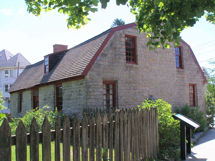
The Nathaniel Hempstead House, also known as the Old Huguenot House, is a historic house museum on Hempstead Street in New London, Connecticut. Built about 1759, it is an architecturally unusual stone house with a gambrel roof, a style not otherwise seen in the city. Because of its unusual form, it was thought to have been built by French Huguenot immigrants at an earlier date. The house is owned by Connecticut Landmarks, along with the adjacent Joshua Hempsted House, operating the pair as the Hempstead Houses museum. The house was listed on the National Register of Historic Places on December 2, 1970.

Wikipedia: Nathaniel Hempstead House (EN)

234 meters / 3 minutes

Sight 6: Hempstead Historic District

Show sight on map

The Hempstead Historic District of New London, Connecticut encompasses a residential area north of the city's harbor and central business district, extending mainly along three roughly parallel streets: Franklin and Hempstead Streets, and Mountain Avenue. The area was settled in the 17th century, and has three centuries of architecture depicting an increasingly urban area. The district was listed on the National Register of Historic Places on July 31, 1986.

Wikipedia: Hempstead Historic District (EN), Heritage Website

436 meters / 5 minutes

Sight 7: Williams Memorial Park Historic District

Show sight on map

The Williams Memorial Park Historic District is located in New London, Connecticut, roughly bounded by Hempstead, Broad, Mercer and Williams Streets, with houses on Broad Street south to Cottage Street included. Williams Memorial Park – which was designed by Frederick Law Olmsted – is also included, as is the Civil War monument located there; 16 houses are part of the district, while two buildings – a brick office building at 43 Broad Street and an apartment building at 127 Hempstead Street, are non-contributing properties. Four of the six outbuildings in the district are contributing. Nine different architectural styles are represented in the district.

Wikipedia: Williams Memorial Park Historic District (EN), Heritage Website

401 meters / 5 minutes

Sight 8: Williams Memorial Institute Building

Show sight on map

The Williams School is a private co-educational secondary school in New London, Connecticut, that offers classes from 6th grade to 12th grade. It was founded as the Williams Memorial Institute (WMI) by Harriet Peck Williams in 1891, following the death of her son Thomas W. Williams II, a well-known whaling merchant.

Wikipedia: The Williams School (EN), Heritage Website

409 meters / 5 minutes

Sight 9: Prospect Street Historic District

Show sight on map

The Prospect Street Historic District encompasses approximately 5.5 acres northwest of the central business district of New London, Connecticut. The district is bounded by Bulkeley Place on the north, Hempstead Street on the west, Federal Street on the south and Huntington Street on the east. Prospect Street bisects the district on a north-south axis. The residential area includes 24 buildings, most of which are Greek Revival or Italianate houses built between 1838 and 1859. The area was developed in response to local demand for increased middle-class housing, and the dense development and modest scale of the buildings is reflective of this objective.

Wikipedia: Prospect Street Historic District (EN), Heritage Website

251 meters / 3 minutes

Sight 10: Saint James Episcopal Church

Show sight on map

St. James Episcopal Church at 76 Federal Street at the corner of Huntington Street in New London, Connecticut is a historic church in the Episcopal Diocese of Connecticut. The congregation was founded in 1725, and the current church – the congregation's third – was built from 1847 to 1850 to designs in the Gothic Revival style by Richard Upjohn.

Wikipedia: St. James Episcopal Church (New London, Connecticut) (EN), Website, Heritage Website

137 meters / 2 minutes

Sight 11: Whale Oil Row

Show sight on map

Whale Oil Row is a collection of four similar, high-quality Greek Revival houses standing side by side at 105–119 Huntington Street in New London, Connecticut. All were built for developer Ezra Chappel between 1835 and 1845 by Charles Henry Boebe, and they exemplify the wealth and taste of New London's whaling-funded upper class. They were added to the National Register of Historic Places in 1970.

Wikipedia: Whale Oil Row (EN), Heritage Website

219 meters / 3 minutes

Sight 12: Public Library of New London

Show sight on map

The Public Library of New London is a historic library located at 63 Huntington Street at the corner of State Street, New London, Connecticut. The library was given to the city by Henry Philomen Haven. It was constructed in 1889-92 and was designed by Shepley, Rutan and Coolidge in the Richardsonian Romanesque style; George Warren Cole was the project supervisor.

Wikipedia: New London Public Library (EN), Heritage Website

109 meters / 1 minutes

Sight 13: Huntington Street Baptist Church

Show sight on map

The Huntington Street Baptist Church is a historic Baptist Church meeting house at 29 Huntington Street in New London, Connecticut. Built in 1843 by John Bishop, who also designed it, it is one of the last major examples of Greek Revival architecture to be built in the city. The church was built by a Universalist congregation and then purchased by a Baptist one. The building was listed on the National Register of Historic Places in 1982. As of 2017, the church is still in use as a Baptist house of worship.

Wikipedia: Huntington Street Baptist Church (EN), Heritage Website

138 meters / 2 minutes

Sight 14: Downtown New London Historic District

Show sight on map

The Downtown New London Historic District, also known as the Waterfront Historic District, refers to 78 acres (32 ha) with 222 contributing buildings along the waterfront of New London, Connecticut. It was added to the National Register of Historic Places (NRHP) in 1979, with 190 buildings and 60 acres (24 ha). The district was expanded in 1988, adding 18 acres (7.3 ha) and 33 buildings.

Wikipedia: Downtown New London Historic District (EN), Heritage Website

178 meters / 2 minutes

Sight 15: Coit Street Historic District

Show sight on map

The Coit Street Historic District in New London, Connecticut is a historic district that was listed on the National Register of Historic Places in 1988. It includes 33 contributing buildings over a 4 acres (1.6 ha) area, located just southwest of the city's central business district. The area included in the district was formerly known as Bream Cove, which was filled in and developed in the 19th century. The area includes four out of twelve surviving 18th-century buildings in the city. It includes all of the properties on Coit and Brewer Streets, as well as those on Blinman Street between those two streets.

Wikipedia: Coit Street Historic District (EN), Heritage Website

419 meters / 5 minutes

Sight 16: Centro de la Comunidad

Show sight on map

The Ohev Sholem Synagogue is an historic former Jewish synagogue building, located at 109 Blinman Street in New London, Connecticut, in the United States.

Wikipedia: Ohev Sholem Synagogue (New London, Connecticut) (EN), Website, Heritage Website

703 meters / 8 minutes

Sight 17: Custom House Maritime Museum

Show sight on map

The New London Custom House is a historic custom house at 150 Bank Street in New London, Connecticut, built in 1833-35. It was designed by Robert Mills, one of the country's first formally trained architects. From 1839-40, the schooner La Amistad, on which captured Africans meant for the slave trade rebelled, was impounded at a wharf behind the customhouse. It was listed on the National Register of Historic Places for its architecture in 1970, and is now a local museum covering the city's maritime history.

Wikipedia: New London Customhouse (EN), Website, Heritage Website

443 meters / 5 minutes

Sight 18: First Congregational Church

Show sight on map

The First Church of Christ, also called the First Congregational Church, was a Gothic Revival-style church located in New London, Connecticut. It was completed in 1853, designed by Prague-born architect Leopold Eidlitz. This large granite edifice featured a tall central spire, rising in three stages and flanked by two lower towers with pitched roofs. It occupied a prominent position on Union Street, across from the City Hall, anchoring the Downtown New London Historic District.

Wikipedia: First Church of Christ (New London, Connecticut) (EN), Website

45 meters / 1 minutes

Sight 19: New London Post Office

Show sight on map

The U.S. Post Office-New London Main is located at 27 Masonic Street in New London, Connecticut. Completed in 1934 as part of a Depression-era jobs program, it is one of the small number of such post offices designed by a private architectural firm, Payne & Keefe. The building was listed on the National Register of Historic Places in 1986.

Wikipedia: United States Post Office–New London Main (EN), Heritage Website

Share

Spread the word! Share this page with your friends and family.

Disclaimer Please be aware of your surroundings and do not enter private property. We are not liable for any damages that occur during the tours.

GPX-Download For navigation apps and GPS devices you can download the tour as a GPX file.