Self-guided Sightseeing Tour #3 in London, United Kingdom
Legend
Guided Free Walking Tours
Book free guided walking tours in London.
Guided Sightseeing Tours
Book guided sightseeing tours and activities in London.
Tour Facts
1.9 km
21 m
Experience London in United Kingdom in a whole new way with our free self-guided sightseeing tour. This site not only offers you practical information and insider tips, but also a rich variety of activities and sights you shouldn't miss. Whether you love art and culture, want to explore historical sites or simply want to experience the vibrant atmosphere of a lively city - you'll find everything you need for your personal adventure here.
Activities in LondonIndividual Sights in LondonSight 1: Our Lady of Carmel and St. Simon Stock

The church of Our Lady of Mount Carmel and St Simon Stock is a Roman Catholic church at 41 Kensington Church Street, Kensington, London W8, served by Discalced Carmelites.
Wikipedia: Our Lady of Mount Carmel and St Simon Stock (EN), Website
Sight 2: St Mary Abbots

St Mary Abbots is a church located on Kensington High Street and the corner of Kensington Church Street in London W8.
Sight 3: Sambourne House

Sambourne House, previously known as 18 Stafford Terrace and Linley Sambourne House, was the home of the Punch illustrator Edward Linley Sambourne (1844–1910) in Kensington, London. The house, now Grade II* listed, is currently open to the public as a museum.
Sight 4: Design Museum

The Design Museum in Kensington, London, England, exhibits product, industrial, graphic, fashion, and architectural design. In 2018, the museum won the European Museum of the Year Award. The museum operates as a registered charity, and all funds generated by ticket sales aid the museum in curating new exhibitions.
Sight 5: Opera Holland Park

Opera Holland Park is a summer opera company which produces an annual season of opera performances, staged under a temporary canopy in front of the remains of Holland House, a Blitz-damaged building in Holland Park, west central London. The venue is fully covered but is open at the sides.
Sight 6: Holland House
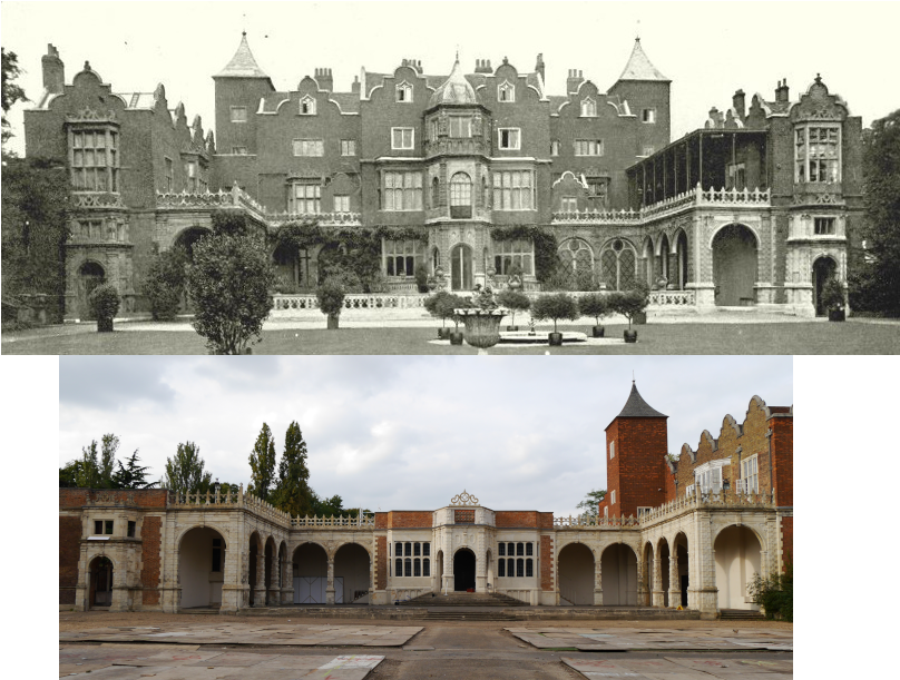
Holland House, originally known as Cope Castle, was an early Jacobean country house in Kensington, London, situated in a country estate that is now Holland Park. It was built in 1605 by the diplomat Sir Walter Cope. The building later passed by marriage to Henry Rich, 1st Baron Kensington, 1st Earl of Holland, and by descent through the Rich family, then became the property of the Fox family, during which time it became a noted gathering-place for Whigs in the 19th century. The house was largely destroyed by German firebombing during the Blitz in 1940 and today only the east wing and some ruins of the ground floor and south facade remain, along with various outbuildings and formal gardens. In 1949 the ruin was designated a grade I listed building and it is now owned by the Royal Borough of Kensington and Chelsea.
Sight 7: Holland Park

Holland Park is an area of Kensington, on the western edge of Central London, that lies within the Royal Borough of Kensington and Chelsea and largely surrounds its namesake park, Holland Park.
Share
How likely are you to recommend us?
Disclaimer Please be aware of your surroundings and do not enter private property. We are not liable for any damages that occur during the tours.
GPX-Download For navigation apps and GPS devices you can download the tour as a GPX file.