Self-guided Sightseeing Tour #2 in Valencia, Spain
Legend
Guided Free Walking Tours
Book free guided walking tours in Valencia.
Guided Sightseeing Tours
Book guided sightseeing tours and activities in Valencia.
Tour Facts
4.9 km
80 m
Experience Valencia in Spain in a whole new way with our free self-guided sightseeing tour. This site not only offers you practical information and insider tips, but also a rich variety of activities and sights you shouldn't miss. Whether you love art and culture, want to explore historical sites or simply want to experience the vibrant atmosphere of a lively city - you'll find everything you need for your personal adventure here.
Activities in ValenciaIndividual Sights in ValenciaSight 1: Jardins del Real

The Jardines del Real, also called Jardines de Viveros, are an urban public park in Spain located in the city of Valencia.
Sight 2: Almodí

The Almudín building is located in Plaza Sant Lluís Bertrán number 1 in the city of Valencia (Spain).
Sight 3: Iglesia de San Esteban

St. Stephen's Church is a Catholic parish church located in the Plaça de Sant Esteve in the city of Valencia, Valencian Community, Spain.
Sight 4: Palau del marques de campo

The Palace of the Marquis of Campo or of the Berbedel is located in the Plaza del Arquebisbe n. 3 in the city of Valencia. It is a residential building built in the seventeenth century, with works carried out in the nineteenth century. It houses the City Museum.
Sight 5: Valencia Cathedral
Get Ticket*
Valencia Cathedral, at greater length the Metropolitan Cathedral–Basilica of the Assumption of Our Lady of Valencia, also known as St Mary's Cathedral, is a Catholic church in Valencia, Spain.
Sight 6: Basilica of the Virgin of the Helpless

The Basilica of the Virgin of the Forsaken in the city of Valencia houses the image of the Virgin of the same name, the most venerated by Valencians.
Sight 7: Palau de Benicarló

The Palace of Benicarló is an aristocratic palace of Valencian Gothic and Renaissance styles located in the city of Valencia, Spain. It is now the headquarters of the Valencian Parliament.
Sight 8: Torres dels Serrans

The Serrans Gate or Serranos Gate, also known as Serrans Towers or Serranos Towers is one of the twelve gates that formed part of the ancient city wall, the Christian Wall, of the city of Valencia, Spain. It was built in Valencian Gothic style at the end of the 14th century. Its name is probably due to its location in the northwest of the old city centre, making it the entry point for the royal road connecting Valencia with the comarca or district of Els Serrans as well as the entry point for the royal road to Barcelona, or because the majority of settlers near there in the time of James I of Aragon were from the area around Teruel, whose inhabitants were often called serrans by the Valencians. Alternatively, the gate may also have been named after an important family, the Serrans, who lived in a street with the same name.
Sight 9: Palau de la Batlia

The palace of the Batlia, or of the Jàudenes, is located in the Plaza de Manises in Valencia, in the neighborhood of La Seu. It is the headquarters of the Provincial Council of Valencia. It was declared a Historic-Artistic Monument in 1962.
Sight 10: Teatre Talia
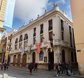
The Talia Theater in Valencia is located at number 31 Calle de los Cavalleros in the capital of the Turia. The building, owned by the Casa dels Obrers de San Vicente Ferrer, has 100 years of history. By virtue of an agreement, the space has been managed since 1992 by Teatres de la Generalitat Valenciana. The hall has 243 fixed seats, 62 boxes on the first floor, 48 amphitheatre seats and 36 boxes on the second floor.
Sight 11: Església de Sant Nicolau

The Church of Sant Nicolau de Bari and Sant Pere Màrtir is a Valencian Gothic style, Catholic parish church located in Valencia, Spain.
Sight 12: Museo de los Soldaditos de Plomo L'Iber

The L'Iber Tin Soldier Museum is located at Calle Caballeros number 20-22, in the old town of the city of Valencia, (Spain).
Wikipedia: Museo de Soldaditos de Plomo L’Iber (ES), Website
Sight 13: Parróquia de la Santísima Cruz

The Church of the Holy Cross, located in the Plaza del Carmen, is one of the most important religious buildings in Valencia, especially for its artistic richness both inside and outside. The building has had the title of National Historic-Artistic Monument since 1983 and is also considered an Asset of Cultural Interest of the city of Valencia.
Sight 14: Consell Valencià de Cultura

The Valencian Council of Culture (CVC) is a consultative and advisory institution of the Generalitat Valenciana in specific matters related to Valencian culture, with the mission of ensuring the defense and promotion of the linguistic and cultural values of the Community. It is made up of 21 members appointed at the proposal of the different political parties represented in the Valencian Parliament.
Sight 15: Valencian Institute of Modern Art

The Institut Valencià d'Art Modern, also known by the acronym IVAM, was the first center of modern art created in Spain, opening in 1989 in the city of Valencia. The Institut Valencià d'Art Modern is an important center for modern and contemporary art in Spain and Europe. Nuria Enguita Mayo was the Director of the museum between September 2020 and February 2024.
Sight 16: Museu de Prehistòria de València

The Prehistory Museum of Valencia is a museum of the city of Valencia, in Spain, that exposes archaeological materials covering from Paleolithic to the Visigoths period.
Sight 17: L'ETNO - Museu Valencià d'Etnologia

The Valencian Museum of Ethnology is a museum located in the city of Valencia, mediterranean Spain. The museum mission defines it as cultural institution primarily devoted to collect, research and communicate the tangible and intangible heritage related to traditional and popular Valencian culture. The mission underlines that the museum also aims to permanently question fundamental aspects of the culture, as the dynamics that built it and force it to evolve, as well as its diversity. Although fundamentally devoted to Valencian cultural identity within a Mediterranean context, this museum also works to give visitors the chance to understand the challenges and dynamics of culture as a whole and from a contemporary perspective.
Sight 18: Església de Santa Úrsula

The Convent of Santa Úrsula is a Roman Catholic convent located in the city center of Valencia, Spain.
Sight 19: Torres de Quart

The Torres de Quart or Puerta de Quart is one of the two remaining gates of the old Valencia city wall. It was built between 1441 and 1493. It was still in use during the Peninsular War when it was marked by cannonballs and musket shots.
Sight 20: Botanic Garden of University of Valencia

The Botanical Garden of the University of Valencia is a botanical garden located in the city of Valencia, within the Valencian Community, Spain.
Wikipedia: Jardín Botánico de la Universidad de Valencia (ES), Website
Share
How likely are you to recommend us?
Disclaimer Please be aware of your surroundings and do not enter private property. We are not liable for any damages that occur during the tours.
GPX-Download For navigation apps and GPS devices you can download the tour as a GPX file.