Self-guided Sightseeing Tour #1 in Dublin 3, Ireland
Legend
Guided Free Walking Tours
Book free guided walking tours in Dublin 3.
Guided Sightseeing Tours
Book guided sightseeing tours and activities in Dublin 3.
Tour Facts
9.5 km
152 m
Experience Dublin 3 in Ireland in a whole new way with our self-guided sightseeing tour. This site not only offers you practical information and insider tips, but also a rich variety of activities and sights you shouldn't miss. Whether you love art and culture, want to explore historical sites or simply want to experience the vibrant atmosphere of a lively city - you'll find everything you need for your personal adventure here.
Individual Sights in Dublin 3Sight 1: St Joseph's Church

St. Joseph's Church is a Catholic church situated on Church Road in the East Wall area of Dublin, Ireland.
Sight 2: The Convention Centre Dublin
The Convention Centre Dublin is a convention centre in the Dublin Docklands, Ireland. The Convention centre overlooks the River Liffey at Spencer Dock. It was designed by the Irish-born American architect Kevin Roche.
Sight 3: Jeanie Johnston
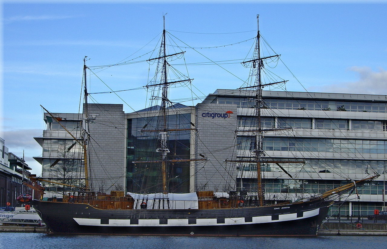
Jeanie Johnston is a replica of a three-masted barque that was originally built in Quebec, Canada, in 1847 by the Scottish-born shipbuilder John Munn. The replica Jeanie Johnston performs a number of functions: it is an ocean-going sail training vessel at sea, and in port, it converts into a living history museum on 19th century emigration and, in the evenings, is used as a corporate event venue.
Wikipedia: Jeanie Johnston (EN), Website, Twitter, Facebook, Tripadvisor
Sight 4: EPIC The Irish Emigration Museum

EPIC The Irish Emigration Museum, located in Dublin's Docklands, covers the history of the Irish diaspora and emigration to other countries. It was designed by the London-based design firm Event Communications, and was voted as "Europe's Leading Tourist Attraction" at the 2019, 2020 and 2021 World Travel Awards.
Sight 5: Famine Memorial

The Famine Memorial, officially titled Famine, is a memorial in Dublin, Ireland. The memorial, which stands on Customs House Quay, is in remembrance of the Great Famine (1845-1849), which saw the population of the country halved through death and emigration.
Sight 6: Universal Links on Human Rights

Universal Links on Human Rights is a memorial sculpture located in Dublin, Ireland, on the traffic island at the junction of Amiens Street, Beresford Place, and Memorial Road, close to Busáras and The Customs House. It is a sphere of welded interlinked chains and bars, 260 cm in diameter, housing an eternal flame in its center, powered by natural gas. It was commissioned by Amnesty International in 1995 and designed by Tony O'Malley. It represents the jails holding prisoners of conscience.
Sight 7: Abbey Theatre

The Abbey Theatre, also known as the National Theatre of Ireland, in Dublin, Ireland, is one of the country's leading cultural institutions. First opening to the public on 27 December 1904, and moved from its original building after a fire in 1951, it has remained active to the present day. The Abbey was the first state-subsidized theatre in the English-speaking world; from 1925 onwards it received an annual subsidy from the Irish Free State. Since July 1966, the Abbey has been located at 26 Lower Abbey Street, Dublin 1.
Sight 8: Wolfe Tone Square

Wolfe Tone Park, also known as Wolfe Tone Square, is a public space in Dublin, Ireland. It is bounded by Mary Street to the north, Jervis Street to the east, and Wolfe Tone Street to the west.
Sight 9: National Leprechaun Museum
The National Leprechaun Museum is a privately owned museum dedicated to Irish folklore and mythology, through the oral tradition of storytelling. It is located on Jervis Street in Dublin, Ireland, since 10 March 2010. It claims to be the first leprechaun museum in the world. The Irish Times has referred to it as the "Louvre of leprechauns".
Sight 10: Wood Quay

Wood Quay is a riverside area of Dublin that was a site of Viking settlement. It is now the location of the Dublin City Council offices.
Sight 11: Smock Alley Theatre

Since the 17th century, there have been numerous theatres in Dublin with the name Smock Alley.
Sight 12: Church of the Immaculate Conception (Adam & Eve)

The Church of the Immaculate Conception, also known as Adam and Eve's, is a Roman Catholic church run by the Franciscans and it is located on Merchants Quay, Dublin.
Sight 13: Saint Audoen's Gate
The San Audoen Gate is an entrance gateway to Dublin through the walls of the middle forested city. The San Audoen Gate is built behind the Church of San Audoen, built in 1190, just 20 years after the Anglo-Norman conquest. This is the oldest parish church in Dublin that is still in use. The church is used as a place of worship by the Church of Ireland. Some of the floors of the old Norman church have medieval gravestones.
Sight 14: St Augustine and St John

The Church of St. Augustine and St. John, commonly known as John's Lane Church, is a large Catholic church located on Thomas Street, Dublin, Ireland. It was opened in 1874 on the site of the medieval St. John's Hospital, founded c. 1180. It is served by the Augustinian Order of friars.
Sight 15: St Catherine's Church

St. Catherine's Church, on Thomas Street, in Dublin, Ireland, was originally built in 1185. It is located on what was once termed the "Slí Mhór", a key route that ran westwards across Ireland from Dublin. The church was rebuilt in its present form in the 18th century by John Smyth.
Wikipedia: St Catherine's Church, Dublin (Church of Ireland) (EN), Website
Sight 16: St Audoen's

St Audoen's is the church of the parish of St Audoen that is located south of the River Liffey at Cornmarket in Dublin, Ireland. The parish is in the Roman Catholic Archdiocese of Dublin. The church is now home to the Polish chaplaincy in Ireland. There is an Anglican church of the same name adjacent to it.
Sight 17: Dublinia

Dublinia is a historical recreation museum and visitor attraction in Dublin, Ireland, focusing on the Viking and Medieval history of the city. Dublinia is located in a part of Dublin's Christ Church Cathedral, known as the Synod hall.
Wikipedia: Dublinia (EN), Website, Twitter, Facebook, Instagram
Sight 18: Christ Church Cathedral

Christ Church Cathedral, more formally The Cathedral of the Holy Trinity, is the cathedral of the United Dioceses of Dublin and Glendalough and the cathedral of the ecclesiastical province of the United Provinces of Dublin and Cashel in the (Anglican) Church of Ireland. It is situated in Dublin, Ireland, and is the elder of the capital city's two medieval cathedrals, the other being St Patrick's Cathedral.
Sight 19: St Werburgh's

St. Werburgh's Church is a Church of Ireland church building in Dublin, Ireland. The original church on this site was built in 1178, shortly after the arrival of the Anglo-Normans in the town. It was named after St. Werburgh, abbess of Ely and patron saint of Chester. The current building was constructed in 1719. It is located in Werburgh Street, close to Dublin Castle.
Sight 20: Dublin Castle

Dublin Castle is a major Irish government complex, conference centre, and tourist attraction. It is located off Dame Street in central Dublin.
Sight 21: Garda Museum

The Garda Museum is a police museum located in Dublin, Ireland, located in the Treasury Building of Dublin Castle.
Wikipedia: Garda Museum (EN), Flickr, Website, Twitter, Facebook, Operator Website
Sight 22: The Sick and Indigent Roomkeepers' Society

The Sick and Indigent Roomkeepers Society in Dublin, Ireland, is the city's oldest surviving charity.
Wikipedia: The Sick and Indigent Roomkeepers' Society (EN), Website
Sight 23: Olympia Theatre

The Olympia Theatre, branded since 2021 for sponsorship purposes as the 3Olympia Theatre, is a concert hall and theatre venue in Dublin, Ireland, located on Dame Street.
Sight 24: Ha'penny Bridge

The Ha'penny Bridge, known later for a time as the Penny Ha'penny Bridge, and officially the Liffey Bridge, is a pedestrian bridge built in May 1816 over the River Liffey in Dublin, Ireland. Made of cast iron, the bridge was cast in Shropshire, England.
Sight 25: Temple Bar

Temple Bar is an area on the south bank of the River Liffey in central Dublin, Ireland. The area is bounded by the Liffey to the north, Dame Street to the south, Westmoreland Street to the east and Fishamble Street to the west. It is promoted as Dublin's 'cultural quarter' and, as a centre of Dublin's city centre's nightlife, is a tourist destination. Temple Bar is in the Dublin 2 postal district.
Sight 26: Molly Malone

Molly Malone is a statue on Suffolk Street in Dublin, the capital of Ireland. The statue depicts the presumably fictional character Molly Malone, who is described in the song of the same title, also known as "Cockles and Mussels". It has previously stood on Grafton Street, but has had the current location since 2014.
Sight 27: Douglas Hyde Gallery
The Douglas Hyde Gallery is a publicly funded contemporary art gallery situated within the historical setting of Trinity College in Dublin, Ireland.
Sight 28: Book of Kells

The Book of Kells is an illuminated manuscript and Celtic Gospel book in Latin, containing the four Gospels of the New Testament together with various prefatory texts and tables. It was created in a Columban monastery in either Ireland or Scotland, and may have had contributions from various Columban institutions from each of these areas. It is believed to have been created c. 800 AD. The text of the Gospels is largely drawn from the Vulgate, although it also includes several passages drawn from the earlier versions of the Bible known as the Vetus Latina. It is regarded as a masterwork of Western calligraphy and the pinnacle of Insular illumination. The manuscript takes its name from the Abbey of Kells, County Meath, which was its home for centuries.
Sight 29: St Mark's

St Mark's Church is a Pentecostal church located at 42A Pearse Street, Dublin, Ireland. The church is affiliated with Christian Churches Ireland, the Irish branch of the Assemblies of God. The church has two Sunday services; 10am and 11:45am.
Share
Disclaimer Please be aware of your surroundings and do not enter private property. We are not liable for any damages that occur during the tours.
GPX-Download For navigation apps and GPS devices you can download the tour as a GPX file.