Self-guided Sightseeing Tour #3 in Trier, Germany
Legend
Tour Facts
5.7 km
60 m
Experience Trier in Germany in a whole new way with our free self-guided sightseeing tour. This site not only offers you practical information and insider tips, but also a rich variety of activities and sights you shouldn't miss. Whether you love art and culture, want to explore historical sites or simply want to experience the vibrant atmosphere of a lively city - you'll find everything you need for your personal adventure here.
Activities in TrierIndividual Sights in TrierSight 1: Balduinbrunnen

The Balduinbrunnen is a fountain in the Rhineland-Palatinate city of Trier (Mosel) at the beginning of Balduinstraße in the Mitte district. The fountain is a monument in memory of Baldwin of Luxembourg, who was Archbishop of Trier from 1307 to 1354 and one of the electors in the Holy Roman Empire of the German Nation. It is a dominant building in terms of urban development, whose location at the intersection of Christophstraße and Balduinstraße in the northeast of the Alleenring was originally intended for the Kaiser Wilhelm Monument, which was erected on 15 May 1893 on the Domfreihof. The distance of the fountain to Trier Central Station is about 200 meters.
Sight 2: Electoral Palace
Get Ticket*
The Electoral Palace in Trier, Germany, was the residence of the Archbishops and Electors of Trier from the 16th century until the late 18th century. It now houses various offices of the federal government and often hosts classical music concerts.
Sight 3: Kaiserthermen

The Trier Imperial Baths are a large Roman bath complex in Trier, Germany. The complex was constructed in the early 4th century AD, during the reign of Constantine I. During that time, Trier was a major imperial hub, being a primary residence for Constantine's son Crispus. The baths were built around hot water pools reaching 40°C. Underneath the complex was a network of underground passageways used by the staff which can still be seen today, along with the remains of the sewer system. However, the baths were never completed and were made into a castle in the Middle Ages.
Wikipedia: Trier Imperial Baths (EN), Website, Heritage Website
Sight 4: Konstantinbasilika

The Aula Palatina, also called Basilica of Constantine, at Trier, Germany, is a Roman palace basilica and an early Christian structure built between AD 300 and 310 during the reigns of Constantius Chlorus and Constantine the Great.
Sight 5: Palais Kesselstatt

The Palais Kesselstatt is a cultural monument in the Liebfrauenstraße in Trier in Rhineland-Palatinate.
Sight 6: Jesuitenkirche

The Jesuit Church in Trier is a former monastery church of the Franciscans from the 1st half of the 13th century. It is dedicated to the Holy Trinity.
Sight 7: Sankt Georgsbrunnen

The Georgsbrunnen is a fountain in the Mitte/Gartenfeld district of Trier, Germany. It is considered one of the most beautiful rococo fountains in Germany.
Sight 8: Karl-Marx-Haus
Get Ticket*
The Karl Marx House museum is a biographical and writer's house museum in Trier. In 1818, Karl Marx, the father of Marxism, which influenced both modern socialism and communism, was born in the house. It is now a museum about Karl Marx's life and writings as well as the communism and socialism.
Sight 9: St. Josef

The former Redemptorist monastery of Sankt Josef is a monastery building with an associated three-aisled church in Trier, Feldstraße 18, built in 1854–55, three-storey complex in neo-Romanesque style made of red sandstone.
Sight 10: Hochbunker Augustinerhof

The Augustinerhof bunker, also known as the Augustinerhof bunker, is one of five surviving bunkers in Trier.
Sight 11: Theater Trier
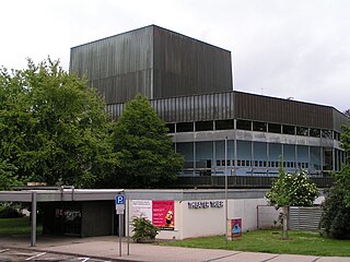
The Theater Trier is the municipal theatre of Trier, Rhineland-Palatinate, offering opera and musical, dance and drama. The company dates back to 1802. The current house was completed in 1964, and needs renovation. The director since 2018 is Manfred Rolf Langner.
Sight 12: St. Antonius

St. Antonius is a Roman Catholic church in Trier, Germany. It is located in the Mitte district on Antoniusstraße near the Viehmarkt and belongs to the parish of Liebfrauen in the Diocese of Trier.
Sight 13: Thermen am Viehmarkt

49.752736°N 6.63766°E The Forum Baths of Trier are a ruin of a Roman bath complex in Augusta Treverorum, modern-day Trier, Germany. The baths were discovered in 1987.
Sight 14: Roter Turm

The Red Tower, also known as the Bastion Südallee, is a building of Trier's medieval and modern city wall. It is now located in the Grüngürtel monument zone in Kaiserstraße opposite No. 24.
Sight 15: Barbarathermen
Get Ticket*
The Barbara Baths are a large Roman bath complex in Augusta Treverorum, modern-day Trier, Germany. Stretching over 42,000 square meters, it is the largest Roman bath north of the Alps. Along with other sites in Trier, the bath complex was designated a UNESCO World Heritage Site in 1986 as part of the Roman Monuments, Cathedral of St. Peter and Church of Our Lady in Trier site, because of its historical importance and sprawling architecture.
Sight 16: Römerbrücke
Get Ticket*
The Roman Bridge is an ancient structure in Trier, Germany, over the Moselle. It is the oldest standing bridge in the country, and the oldest Roman bridge north of the Alps. The nine bridge pillars date from the 2nd century AD, replacing two older, wooden bridges that date at least as far back as 17 BC. In Roman times, tossing a coin off of the bridge into the Moselle was an offering of good luck. The upper part was renewed twice, in the early 12th and in the early 18th century, after suffering destruction in war. Along with other Roman and Early Gothic sites in Trier, the bridge was inscribed on the UNESCO World Heritage List in 1986 because of its historical importance and architecture.
Share
How likely are you to recommend us?
Disclaimer Please be aware of your surroundings and do not enter private property. We are not liable for any damages that occur during the tours.
GPX-Download For navigation apps and GPS devices you can download the tour as a GPX file.