Self-guided Sightseeing Tour #5 in Bremerhaven, Germany
Legend
Tour Facts
4.7 km
31 m
Experience Bremerhaven in Germany in a whole new way with our free self-guided sightseeing tour. This site not only offers you practical information and insider tips, but also a rich variety of activities and sights you shouldn't miss. Whether you love art and culture, want to explore historical sites or simply want to experience the vibrant atmosphere of a lively city - you'll find everything you need for your personal adventure here.
Individual Sights in BremerhavenSight 1: Bahnhof Lehe

Bremerhaven-Lehe Personenbahnhof or usually Leher Bahnhof or Bahnhof Lehe is a through station at kilometre 187.8 of the Wunstorf–Bremerhaven Seehafen railway. The station is located in Bremerhaven, Lehe district at Bürgermeister-Kirschbaum-Platz and dates from 1914.
Sight 2: Alte privilegierte Apotheke

The Old Privileged Pharmacy Lehe in Bremerhaven-Lehe, district of Klushof, Poststraße 1, corner of Lange Straße, was built around 1674 and 1802 respectively.
Sight 3: Dionysiuskirche

The Dionysius Church in Lehe (Bremerhaven) on the corner of Lange Straße/Poststraße and Eisenbahnstraße is an Evangelical Lutheran parish church.
Sight 4: Landratsamt Lehe

The Lehe District Administrator's House in Bremerhaven-Lehe, Klushof district, Lange Straße 123, was built in 1830.
Sight 5: Haus Dr. Diekmann

The Dr. Diekmann House in Bremerhaven-Lehe, district of Klushof, Neue Straße 4, was built in 1908 according to plans by Adolf Fischer.
Sight 6: Villa Hanssen

The Villa Hanssen in Bremerhaven - Lehe, district of Klushof, Krumme Straße 18, was built in 1898 according to plans by Carl Pogge.
Sight 7: Kalkofen

The lime kiln in Bremerhaven-Lehe, Bütteler Straße 6, is one of the very few technical facilities of its kind still preserved in Germany.
Sight 8: Kino Aladin

The Aladin cinema was a cinema in Bremerhaven-Lehe at Rickmersstraße 11/13, dates from 1956.
Sight 9: Schwoonscher Wasserturm
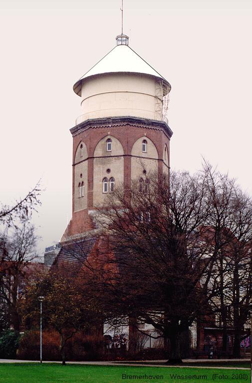
The water tower of Bremerhaven-Lehe stands in today's city park on Hafenstraße. The more than 150-year-old building from the early days of Bremerhaven's water supply – also known as the Schwoon Water Tower after its builder Melchior Schwoon. See also List of water towers in Bremerhaven.
Wikipedia: Wasserturm Bremerhaven-Lehe (Hafenstraße) (DE), Website
Sight 10: Herz-Jesu-Kirche

The Church of Jesus is a Catholic parish church in Bremerhaven-Lehe at Eupener Straße 60; It was built in 1910/11.
Wikipedia: Herz-Jesu-Kirche (Bremerhaven-Lehe) (DE), Website, Website
Sight 11: Zollamt Rotersand

The Rotersand customs office in Lehe (Bremerhaven) is located at Franziusstraße 1, at the end of Rickmersstraße and Bürgermeister-Smidt-Straße. It was the main entrance to the Kaiserhafen and the Nordhafen. Freight traffic is now routed via Speckenbüttel. The office is named after the Roter Sand lighthouse. The city tram ran a single-track curve from Rickmersstraße into the citizens at the office. > The building was placed under Bremen monument protection in 2009.
Sight 12: havenhostel Bremerhaven

The Roter Sand barracks is a former barracks of the police at the old Rotersand customs office in Bremerhaven - Mitte, Bürgermeister-Smidt-Straße 209 at the corner of Rickmersstraße.
Share
How likely are you to recommend us?
Disclaimer Please be aware of your surroundings and do not enter private property. We are not liable for any damages that occur during the tours.
GPX-Download For navigation apps and GPS devices you can download the tour as a GPX file.