Self-guided Sightseeing Tour #4 in Besançon, France
Legend
Tour Facts
3.9 km
246 m
Experience Besançon in France in a whole new way with our free self-guided sightseeing tour. This site not only offers you practical information and insider tips, but also a rich variety of activities and sights you shouldn't miss. Whether you love art and culture, want to explore historical sites or simply want to experience the vibrant atmosphere of a lively city - you'll find everything you need for your personal adventure here.
Activities in BesançonIndividual Sights in BesançonSight 1: Citadelle de Besançon
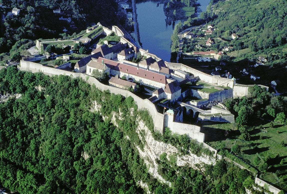
The Citadel of Besançon is a 17th-century fortress in Franche-Comté, France. It is one of the finest masterpieces of military architecture designed by Sébastien Le Prestre de Vauban. The Citadel occupies 11 hectares on Mount Saint-Etienne, one of the seven hills that protect Besançon, the capital of Franche-Comté. Mount Saint-Etienne occupies the neck of an oxbow formed by the river Doubs, giving the site a strategic importance that Julius Caesar recognised as early as 58 BC. The Citadel overlooks the old quarter of the city, which is located within the oxbow, and has views of the city and its surroundings.
Sight 2: Horloge astronomique

The Besançon astronomical clock is housed in Besançon Cathedral. Auguste-Lucien Vérité of Beauvais designed and built Besançon's present astronomical clock, between 1858 and 1863. It replaced an earlier clock that Bernardin had constructed in the 1850s that proved unsatisfactory. Besançon's clock differs from those in Strasbourg, Lyon, and Beauvais. The clock is meant to express the theological concept that each second of the day the Resurrection of Christ transforms the existence of man and of the world.
Sight 3: Cathédrale Saint-Jean

Besançon Cathedral is a Roman Catholic church dedicated to Saint John located in the city of Besançon, France. It is the seat of the Archbishop of Besançon.
Sight 4: Château d'eau de la source d'Arcier

The Arcier Spring Water Tower, known as the Saint Jean Reservoir, is a water tower located in Besançon in the French department of Doubs.
Sight 5: Fontaine des Dames

The Fontaine des Dames is a public fountain located in Besançon in the Doubs department.
Sight 6: Abbaye des Bénédictins de Saint-Vincent (ancienne)

The Notre-Dame church is located on rue Mégevand, in the Boucle district, in Besançon (Doubs).
Sight 7: Théâtre Ledoux

The Ledoux Theater is a performance, opera, theater and concert hall, located in the historic center of Besançon, formerly known as the musical theater.
Sight 8: Fontaine du Doubs

The Fontaine du Doubs is a public fountain located in Besançon in the Doubs department.
Sight 9: Hôtel de Grammont

The former Archiepiscopal Palace of Besançon is a building located in Besançon in the Doubs department.
Sight 10: Porte noire (Arc de triomphe gallo-romain)

The Porte Noire is a Roman triumphal arch in Besançon, France.
Sight 11: Porte Rivotte

The Porte Rivotte is a military building located in the Rivotte sector, near the historic center of Besançon. It is one of the last two city gates of Besançon, along with the Carved Gate, still elevated.
Sight 12: Fonds régional d'art contemporain (FRAC)
The Franche-Comté Regional Contemporary Art Fund is a regional contemporary art fund created by the Franche-Comté region in 1982.
Wikipedia: Fonds régional d'art contemporain de Franche-Comté (FR)
Sight 13: La Rodia

La Rodia is a French concert hall located in Besançon in the Doubs department and in the Bourgogne-Franche-Comté region.
Share
How likely are you to recommend us?
Disclaimer Please be aware of your surroundings and do not enter private property. We are not liable for any damages that occur during the tours.
GPX-Download For navigation apps and GPS devices you can download the tour as a GPX file.