Self-guided Sightseeing Tour #1 in Kongens Lyngby, Denmark
Legend
Tour Facts
2.6 km
34 m
Experience Kongens Lyngby in Denmark in a whole new way with our self-guided sightseeing tour. This site not only offers you practical information and insider tips, but also a rich variety of activities and sights you shouldn't miss. Whether you love art and culture, want to explore historical sites or simply want to experience the vibrant atmosphere of a lively city - you'll find everything you need for your personal adventure here.
Activities in Kongens LyngbyIndividual Sights in Kongens LyngbySight 1: Lundtofte Kirke

Lundtofte Church is a Church of Denmark parish church in Lyngby-Taarbæk Municipality in the northern suburbs of Copenhagen, Denmark. It was completed in 1921 but is built in the style of a typical Danish white-washed village church.
Sight 2: Brede Vandtårn

Brede Water Tower was built in 1907-08 by G.R. Øllgaard in Hellerup and was built for Brede Klædefabrik, which today is part of the National Museum. The 16 m high tower is still in use and can accommodate 80 m3. During the Occupation, the resistance movement used the space under the water tank to store weapons. The tower was listed in 1991.
Sight 3: Brede Hovedbygning

Brede House is a late 18th-century country house in Kongens Lyngby north of Copenhagen, Denmark. Originally built for the owner of the adjacent Brede Works, it is now owned by the National Museum of Denmark and run as a historic house museum.
Sight 4: Brede Værk
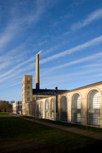
The National Museum of Denmark's new museum, Brede Works, lies in the countryside just north of Copenhagen in Denmark's largest, protected industrial plants. At the museum of Industrial culture, the visitors can be guided around by its own virtual person between old machines, hear how Denmark became an industrial society and even try to work at an assembly line. The exhibitions show the industrial development which has changed the everyday lives of the Danes over the past few centuries.
Sight 5: Frilandsmuseet

Frilandsmuseet is an open-air museum on the northern outskirts of Copenhagen, Denmark. The museum is located in Lyngby on Kongevejen in North Zealand. The museum can be reached directly by bus number 184 from Nørreport Station in central Copenhagen or by S-train to Sorgenfri station.
Share
Disclaimer Please be aware of your surroundings and do not enter private property. We are not liable for any damages that occur during the tours.
GPX-Download For navigation apps and GPS devices you can download the tour as a GPX file.