Self-guided Sightseeing Tour #3 in Hong Kong, China
Legend
Tour Facts
9.8 km
679 m
Experience Hong Kong in China in a whole new way with our free self-guided sightseeing tour. This site not only offers you practical information and insider tips, but also a rich variety of activities and sights you shouldn't miss. Whether you love art and culture, want to explore historical sites or simply want to experience the vibrant atmosphere of a lively city - you'll find everything you need for your personal adventure here.
Individual Sights in Hong KongSight 1: Hong Kong Maritime Museum

Hong Kong Maritime Museum is a non-profit educational institution funded by the international shipping community and the government in Hong Kong. It is located at Central Pier 8, Hong Kong. The museum was established on 8 September in 2005 and reopened to the public in February 2013.
Sight 2: The Cenotaph

The Cenotaph is a war memorial constructed in 1923 and located between Statue Square and the City Hall in Central, Hong Kong, that commemorates the dead in the two world wars who served in Hong Kong in the Royal Navy, British Army and Royal Air Force. Built in stone, it is an almost exact replica of the Cenotaph on Whitehall in London, UK. It is listed as a monument under the Antiquities and Monuments Ordinance.
Sight 3: Chater Garden

Chater Garden, located in the Central District of Hong Kong, is a public park directly east of the Legislative Council building. It is named after Sir Paul Chater, as is the adjacent Chater Road.
Sight 4: St. John's Cathedral

The Cathedral Church of Saint John the Evangelist is the cathedral of the Anglican Diocese of Hong Kong Island, and mother church to the Province of Hong Kong and Macao. It is the seat of the Archbishop of Hong Kong and the Bishop of Hong Kong Island.
Sight 5: Cheung Kong Park

Cheung Kong Park is a small garden located in the Central district of Hong Kong Island and named for Li Ka Shing's corporate empire. The park is privately maintained by Cheung Kong Holdings, but is open to the public. The park consists of ponds and cascades with benches for visitors.
Sight 6: HSBC Main Building

The HSBC Head Office Building is located in Central, Hong Kong, and is the head office of The Hongkong and Shanghai Banking Corporation Limited. Sandwiched between Queen's Road Central and Des Voeux Road Central, the building is close to Statue Square, Standard Chartered Bank Building and MTR Central Station. Its registered address is 1 Queen's Road Central; Some people mistakenly think that the entrance of Des Voeux Road, where the bronze lion is located facing Statue Square, is the main entrance, and the real main entrance is the entrance to Queen's Road in the center of the Cheung Kong Group.
Sight 7: Bank of China Building

Bank of China Building is located at no.2A Des Voeux Road Central, Central, Hong Kong. It is a sub-branch of Bank of China.
Sight 8: Statue of Sir Thomas Jackson, 1st Baronet

The statue of Sir Thomas Jackson, 1st Baronet is a bronze sculpture by Mario Raggi, installed in Statue Square, a public pedestrian square in Central, Hong Kong. It was unveiled on 24 February 1906 by the Governor of Hong Kong, Sir Matthew Nathan. At that time, the statue was facing the HSBC building.
Sight 9: Pedder Building

The Pedder Building, located at No. 12 Pedder Street, in Central, Hong Kong, is a historic commercial building built in the Beaux-Arts style. Built in 1923, it is the last surviving pre-World War II building in Pedder Street.
Sight 10: Lan Kwai Fong

Lan Kwai Fong is a small square of streets in Central, Hong Kong. The area was dedicated to hawkers before the Second World War, but underwent a renaissance in the mid-1980s. It is now a popular expatriate haunt in Hong Kong for drinking, clubbing, and dining. The street Lan Kwai Fong is L-shaped with two ends joining with D'Aguilar Street.
Sight 11: Hong Kong Sheng Kung Hui
The Hong Kong Sheng Kung Hui (abbreviated SKH), also known as the Hong Kong Anglican Church (Episcopal), is the Anglican church in Hong Kong and Macao. It is the 38th Province of the Anglican Communion. It is also one of the major denominations in Hong Kong and the first in the Anglican Communion to ordain a female priest.
Sight 12: Government House

Government House, located on Government Hill in Central, Hong Kong, is the official residence of the Chief Executive of Hong Kong. It was constructed in 1855 as a Colonial Renaissance-style building, but was significantly remodelled during the Japanese occupation, resulting in the current hybrid Japanese-neoclassical form.
Sight 13: Victoria Prison

Victoria Prison, was the first and longest-running prison to date in Hong Kong. It is located on Old Bailey Street in Central, Hong Kong Island. Named in honour of Queen Victoria, it was originally known as Victoria Gaol and was renamed into Victoria Prison in 1899. Victoria Prison has been redeveloped into a cultural and shopping destination generally called Tai Kwun (大館). Tai Kwun is composed of three declared monuments: the former Central Police Station, former Central Magistracy and Victoria Prison.
Sight 14: Former Central Police Station

The former Central Police Station of Hong Kong, located at the eastern end of Hollywood Road, in Central, Hong Kong has been redeveloped into a cultural and shopping destination generally called Tai Kwun (大館). Tai Kwun is composed of three declared monuments: the former Central Police Station, former Central Magistracy and Victoria Prison.
Sight 15: Central-Mid-Levels Escalator System

The Central–Mid-Levels escalator and walkway system in Hong Kong is the longest outdoor covered escalator system in the world. The system covers over 800 m (2,600 ft) in distance and traverses an elevation of over 135 m (443 ft) from bottom to top. It opened in 1993 to provide an improved link between Central and the Mid-Levels on Hong Kong Island.
Wikipedia: Central–Mid-Levels escalator and walkway system (EN)
Sight 16: SoHo

SoHo is an area of Hong Kong located on the western edge of Central, bordering Sheung Wan, known for its bars, restaurants and entertainment venues. The name is derived from its location: South of Hollywood Road.
Sight 17: Bridges Street Market

Bridges Street Market is located at No. 2 Bridges Street, at the corner of Shing Wong Street, in Sheung Wan, Hong Kong. It is a Bauhaus style market building, originally opened in 1953, and has been renovated and open in 2018 as a news museum.
Sight 18: Man Mo Temple

A Man Mo temple, or Man Mo Miu, is a temple for the worship of the civil or literature god Man Tai (文帝), or Man Cheong (文昌), and the martial god Mo Tai (武帝), or Kwan Tai (關帝). The two deities were popularly patronized by scholars and students seeking progress in their study or ranking in the civil examinations in the Ming and Qing dynasties. There are several Man Mo temples in Hong Kong, the best known of which is the temple in Sheung Wan.
Sight 19: Hong Kong Museum of Medical Sciences
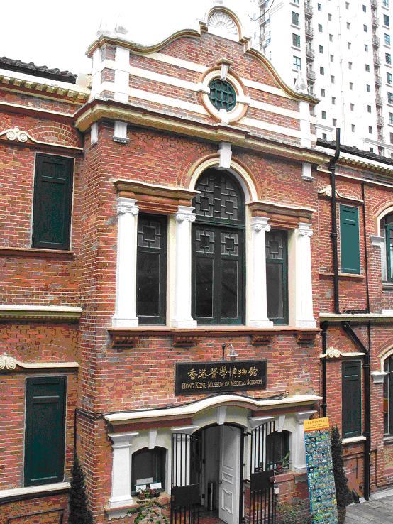
The Hong Kong Museum of Medical Sciences was established in 1996. It is in a renovated three-story Edwardian-style building, at 2 Caine Lane at the Sheung Wan, Hong Kong Island, Hong Kong. It is also referred to as Old Pathological Institute.
Wikipedia: Hong Kong Museum of Medical Sciences (EN), Website
Sight 20: Blake Garden

Blake Garden, also known as Blake Gardens, is a small urban park in Sheung Wan on Hong Kong Island, near Man Mo Temple. The park is named after Sir Henry Arthur Blake, a former British governor of Hong Kong. It includes hard-surface playing areas for football, basketball and badminton/volleyball.
Sight 21: Upper Lascar Row

Lascar Row is the combined name of two streets between Hollywood Road and Queen's Road Central in Sheung Wan, Hong Kong, Upper Lascar Row (摩羅上街) and Lok Ku Road. The immediate area is notable for its antique stalls.
Sight 22: Hollywood Road

Hollywood Road is a street in Central and Sheung Wan, on Hong Kong Island, Hong Kong. The street runs between Central and Sheung Wan, with Wyndham Street, Arbuthnot Road, Ladder Street, Upper Lascar Row, and Old Bailey Street in the vicinity.
Sight 23: Hollywood Road Park

Hollywood Road Park is an urban public park in Sheung Wan, Hong Kong Island, Hong Kong.
Sight 24: King George V Memorial Park

King George V Memorial Park, Hong Kong, is an urban park in Sai Ying Pun and one of the few parks in Hong Kong bearing the former colonial links to the territory's past.
Sight 25: London Mission Building

The London Mission Building is a historic building in Hong Kong, located at 79-80 Robinson Road in the Mid-Levels of Hong Kong Island, and was listed as a Grade 2 historic building in Hong Kong in 2009.
Sight 26: Dr Sun Yat-sen Museum

The Dr Sun Yat-sen Museum is a museum in Central, Hong Kong. It is located in Kom Tong Hall, at 7 Castle Road, Central. After preparatory work undertaken by the Hong Kong Museum of History, the museum opened to the public on 12 December 2006 to commemorate the 140th birthday of the influential Chinese statesman Sun Yat-sen.
Sight 27: 些利街清真寺 Jamia Mosque

The Jamia Mosque is a mosque in Mid-Levels, Hong Kong. The mosque is the oldest mosque in Hong Kong. The neighbouring streets Mosque Street and Mosque Junction are named after this mosque. Mufti Abdul Zaman is the main Imam of this Mosque and he leads prayers and taraweeh in the month of Ramadan.
Sight 28: Cathedral of the Immaculate Conception

The Cathedral of the Immaculate Conception is a late 19th-century English Gothic revival church that serves as the cathedral of the Roman Catholic Diocese of Hong Kong. It is located in the Mid-Levels area of the city at 16 Caine Road.
Wikipedia: Cathedral of the Immaculate Conception (Hong Kong) (EN)
Share
How likely are you to recommend us?
Disclaimer Please be aware of your surroundings and do not enter private property. We are not liable for any damages that occur during the tours.
GPX-Download For navigation apps and GPS devices you can download the tour as a GPX file.