Self-guided Sightseeing Tour #2 in (Old) Ottawa, Canada
Legend
Guided Free Walking Tours
Book free guided walking tours in (Old) Ottawa.
Guided Sightseeing Tours
Book guided sightseeing tours and activities in (Old) Ottawa.
Tour Facts
9.1 km
338 m
Experience (Old) Ottawa in Canada in a whole new way with our free self-guided sightseeing tour. This site not only offers you practical information and insider tips, but also a rich variety of activities and sights you shouldn't miss. Whether you love art and culture, want to explore historical sites or simply want to experience the vibrant atmosphere of a lively city - you'll find everything you need for your personal adventure here.
Individual Sights in (Old) OttawaSight 1: Ottawa French Seventh-day Adventist Church

The Ottawa French Seventh-day Adventist Church is a francophone Seventh-day Adventist church in Ottawa, Ontario, Canada. It is located on King Edward Avenue, just north of Rideau Street.
Sight 2: Dancing Bear

Pauta Saila was an Inuit artist from Kilaparutua, Baffin Island, Canada who resided in Cape Dorset, Nunavut. His sister was artist Sharni Pootoogook.
Sight 3: Connaught Building

The Connaught Building is a historic office building in Ottawa, Ontario, Canada, owned by Public Services and Procurement Canada. It is located at 555 MacKenzie Avenue, just south of the United States Embassy. To the east, the building looks out on the Byward Market, and to the west is MacKenzie Avenue and Major's Hill Park. Today, it houses a portion of Headquarters operations for the Canada Revenue Agency (CRA). The Minister and Commissioner of the CRA have offices in the building.
Sight 4: Major's Hill Park

Major's Hill Park is a park in downtown Ottawa, Ontario. The park stands above the Rideau Canal at the point where it enters the Ottawa River. The parliament buildings can be seen across the canal to the west, to the north of the park is the National Gallery of Canada, and to the east are the United States embassy and the Byward Market. To the south is the Chateau Laurier hotel, built on land that was once part of the park.
Sight 5: Peacekeeping Monument

Reconciliation: The Peacekeeping Monument is a monument in Ottawa, the capital of Canada, commemorating Canada's role in international peacekeeping and the soldiers who have participated and are currently participating, both living and dead.
Sight 6: Notre-Dame Cathedral Basilica

The Notre-Dame Cathedral Basilica is a Roman Catholic minor basilica in Ottawa, Ontario, Canada located on 385 Sussex Drive in the Lower Town neighbourhood. It was designated a National Historic Site of Canada in 1990.
Wikipedia: Notre-Dame Cathedral Basilica (Ottawa) (EN), Website, Heritage Website
Sight 7: Kìwekì Point
The National Capital Commission is the Crown corporation responsible for development, urban planning, and conservation in Canada's Capital Region, including administering most lands and buildings owned by the Government of Canada in the region.
Sight 8: National Gallery of Canada

The National Gallery of Canada, located in the capital city of Ottawa, Ontario, is Canada's national art museum. The museum's building takes up 46,621 square metres (501,820 sq ft), with 12,400 square metres (133,000 sq ft) of space used for exhibiting art. It is one of the largest art museums in North America by exhibition space.
Sight 9: Maman

Maman (1999) is a bronze, stainless steel, and marble sculpture in several locations by the artist Louise Bourgeois. The sculpture, which depicts a spider, is among the world's largest, measuring over 30 ft high and over 33 ft wide (9.27 x 8.91 x 10.24 metres). It includes a sac containing 32 marble eggs and its abdomen and thorax are made of rubbed bronze.
Sight 10: Rideau Canal Celtic Cross
The Rideau Canal Celtic Cross is a memorial in Ottawa, Ontario, Canada, erected to commemorate the workers and their families that died building the Rideau Canal between 1826 and 1832. The granite Celtic cross has five engraved symbols: an Irish harp; a pick and shovel; a mosquito; a wheel barrow, and an explosion. It is erected close to Lock #1, in the Colonel By Valley, below Major's Hill Park and Château Laurier Hotel. The group of volunteers who erected the cross were drawn together in 2002 by the Ottawa and District Labour Council with the goal of erecting the memorial. The committee included representatives of the Workers Heritage Centre Museum and the Irish Society of the National Capital Region. The group had support from the Kingston Irish Folk Club, which has raised a number of monuments in the Kingston area. Upon the unveiling of the cross at the canal's first lock at the Ottawa River, the committee disbanded.
Sight 11: Bytown Museum
Get Ticket*
The Bytown Museum is a museum in Ottawa located in the Colonel By Valley at the Ottawa Locks of the Rideau Canal on the Ottawa River, just below Parliament Hill. Housed in the Commissariat Building, Ottawa's oldest remaining stone building, the museum provides a comprehensive overview of the origins of Bytown and its development and growth into the present city of Ottawa.
Sight 12: Confederation Square

Confederation Square is an urban square in Ottawa, Ontario, Canada, and is considered the second most important ceremonial centre in Canada's capital city, after Parliament Hill. Roughly triangular in area, with Canada's National War Memorial at its centre and the Valiants Memorial at its periphery, the square is bounded by Wellington Street to the north and branches of Elgin Street to the east and west.
Sight 13: Lord Stanley Cup Monument

The Lord Stanley's Gift Monument is a monument in Ottawa, Ontario, Canada. It commemorates the donation of the Stanley Cup ice hockey championship trophy by Canada's Governor-General the Lord Stanley of Preston in 1893. It is located on the eastern end of the Sparks Street Mall. It was constructed at the culmination of a public campaign to commemorate the donation of the trophy.
Sight 14: Centennial Flame
Get Ticket*
The Centennial Flame is a monument on Parliament Hill commemorating the 100th anniversary of the Canadian Confederation. First lit in January 1967, the Flame worked with natural gas and as of 2021 uses biogas, presenting a fountain that does not freeze in winter. Money thrown into it is a donation for people with disabilities, some of whom have received over $5,000.
Sight 15: Parliament Hill
Get Ticket*
Parliament Hill, colloquially known as The Hill, is an area of Crown land on the southern bank of the Ottawa River that houses the Parliament of Canada in downtown Ottawa, Ontario. It accommodates a suite of Gothic revival buildings whose architectural elements were chosen to evoke the history of parliamentary democracy. Parliament Hill attracts approximately three million visitors each year. The Parliamentary Protective Service is responsible for law enforcement on Parliament Hill and in the parliamentary precinct, while the National Capital Commission is responsible for maintaining the nine-hectare (22-acre) area of the grounds.
Sight 16: Centre Block
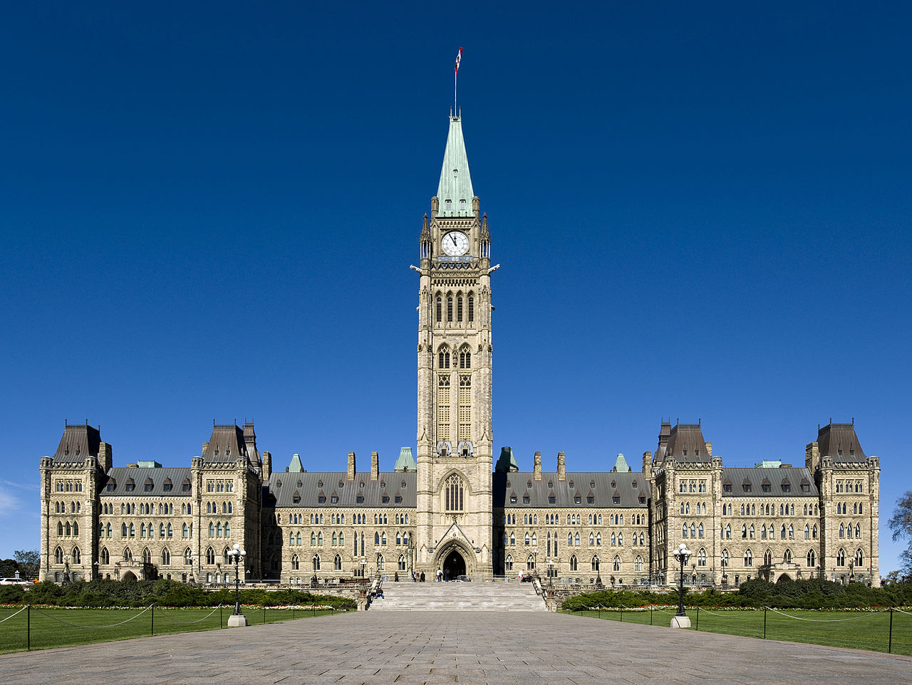
The Centre Block is the main building of the Canadian parliamentary complex on Parliament Hill, in Ottawa, Ontario, containing the House of Commons and Senate chambers, as well as the offices of a number of members of parliament, senators, and senior administration for both legislative houses. It is also the location of several ceremonial spaces, such as the Hall of Honour, the Memorial Chamber, and Confederation Hall.
Sight 17: Library of Parliament
Get Ticket*
The Library of Parliament is the main information repository and research resource for the Parliament of Canada. The main branch of the library sits at the rear of the Centre Block on Parliament Hill in Ottawa, Ontario. The library survived the 1916 fire that destroyed Centre Block. The library has been augmented and renovated several times since its construction in 1876, the last between 2002 and 2006, though the form and decor remain essentially authentic. The building today serves as a Canadian icon, and appears on the obverse of the Canadian ten-dollar bill.
Wikipedia: Library of Parliament (EN), Website, Heritage Website
Sight 18: Sir John A. Macdonald

Sir John Alexander Macdonald was the first prime minister of Canada, serving from 1867 to 1873 and from 1878 until his death in 1891. He was the dominant figure of Canadian Confederation, and had a political career that spanned almost half a century.
Sight 19: Bank of Canada Museum

The Bank of Canada Museum, formerly known as the Currency Museum, opened in 1980 on the ground floor of the Bank of Canada building in Ottawa, Ontario. Temporarily closed in 2013 for major building renovations, the museum reopened in a new space on July 1, 2017, in a new building, with a completely new design and concept. It is, however, connected to the main building through the Bank of Canada's underground conference centre.
Sight 20: St. Andrew's Presbyterian Church

St. Andrew's Presbyterian Church is the oldest Presbyterian church in Ottawa, Ontario, Canada.
Wikipedia: St. Andrew's Presbyterian Church (Ottawa) (EN), Website
Sight 21: Garden of the Provinces and Territories

The Garden of the Provinces and Territories is a 4-acre (1.6 ha) site along Confederation Boulevard in Ottawa, Ontario, Canada's capital city. It is bounded by the Sparks Street escarpment on the south, Wellington Street on the west and north, and Bay Street to the east between Christ Church Cathedral and the Library and Archives Canada. It was officially opened on September 25, 1962, as a western gateway to the Parliament Buildings. The park was renamed from "Garden of the Provinces" on October 6, 2005 to recognize and include Canada's three territories. Scott Brison, then the Minister of Public Works and Government Services Canada, officially renamed the park.
Sight 22: St. Peter's Evangelical Lutheran Church

St. Peter's Evangelical Lutheran Church is a church in Ottawa, Ontario, Canada situated on Ottawa's ceremonial route and overlooks the Garden of the Provinces, the Ottawa River and the Gatineau Hills. St. Peter's is an Ottawa landmark. The motto is "A community of faith seeking to grow in God's grace and love".
Wikipedia: St. Peter's Lutheran Church (Ottawa) (EN), Website
Sight 23: Christ Church Cathedral

Christ Church Cathedral is the Anglican cathedral in Ottawa, Ontario, Canada. The church is located at 414 Sparks Street in the northwest section of the city's downtown at the western end of Sparks Street on top of a promontory looking down to the Ottawa River.
Sight 24: National Holocaust Monument

The National Holocaust Monument is a Holocaust memorial in Ottawa, Ontario, across from the Canadian War Museum at the northeast corner of Wellington and Booth Streets, and about 1.5 km away from Parliament Hill. The memorial was designed by Daniel Libeskind.
Sight 25: Canadian War Museum

The Canadian War Museum (CWM) is a national museum on the country's military history in Ottawa, Ontario, Canada. The museum serves as both an educational facility on Canadian military history and a place of remembrance. The 40,860 square metres (439,800 sq ft) museum building is situated south of the Ottawa River in LeBreton Flats. The museum houses a number of exhibitions and memorials, in addition to a cafeteria, theatre, curatorial and conservation spaces, as well as storage space. The building also houses the Military History Research Centre, the museum's library and archives.
Sight 26: Chaudière Falls

The Chaudière Falls, also known as the Kana:tso or Akikodjiwan Falls, are a set of cascades and waterfall in the centre of the Ottawa-Gatineau metropolitan area in Canada where the Ottawa River narrows between a rocky escarpment on both sides of the river. The location is just west of the Chaudière Bridge and Booth-Eddy streets corridor, northwest of the Canadian War Museum at LeBreton Flats and adjacent to the historic industrial E. B. Eddy complex. The islands surrounding the Chaudière Falls, counter-clockwise, are Chaudière Island, Albert Island, little Coffin Island was just south of Albert Island but is now submerged, Victoria Island and Amelia Island,, Philemon Island was originally called the Peninsular Village by the Wrights but became an island when the timber slide was built in 1829 it is now fused to south shore of City of Gatineau, and Russell Island, now submerged, was at the head of the Falls before the Ring dam was built. The falls are about 60 metres (200 ft) wide and drop 15 metres (49 ft). The area around the falls was once heavily industrialized, especially in the 19th century, driving growth of the surrounding cities.
Share
How likely are you to recommend us?
Disclaimer Please be aware of your surroundings and do not enter private property. We are not liable for any damages that occur during the tours.
GPX-Download For navigation apps and GPS devices you can download the tour as a GPX file.