21 Sights in San Bernardino County, United States (with Map and Images)
Legend
Welcome to your journey through the most beautiful sights in San Bernardino County, United States! Whether you want to discover the city's historical treasures or experience its modern highlights, you'll find everything your heart desires here. Be inspired by our selection and plan your unforgettable adventure in San Bernardino County. Dive into the diversity of this fascinating city and discover everything it has to offer.
1. Nipton

Nipton is an unincorporated community in the Ivanpah Valley in San Bernardino County, California. With a population of about 15 – 20, it is located on the northeastern border of Mojave National Preserve, approximately 12 miles (19 km) southeast of Primm, Nevada and the Ivanpah Solar Power Facility. It is accessible via Nevada State Route 164.
2. Amboy Crater

Amboy Crater is a dormant cinder cone volcano that rises above a 70-square-kilometer (27 sq mi) lava field in the eastern Mojave Desert of southern California, within Mojave Trails National Monument.
3. Roy's Motel and Café
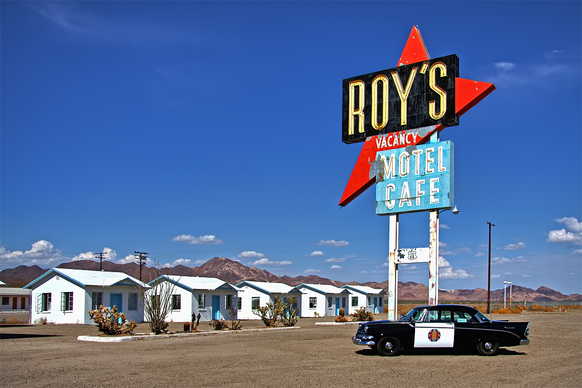
Roy's Motel and Café is a motel, café, gas station and auto repair shop on the National Trails Highway, the former U.S. Route 66, in the Mojave Desert town of Amboy in San Bernardino County, California. It has been defunct for years, but is now being restored. The historic site is an example of roadside Mid-Century Modern Googie architecture. The entire town of Amboy—including the Roy's complex—is owned by and under the stewardship of a private preservationist.
4. Trona Pinnacles

The Trona Pinnacles are an unusual geological feature in the California Desert National Conservation Area. The landscape consists of more than 500 tufa spires, some as high as 140 ft (43 m), rising from the bed of the Searles Lake (dry) basin. The pinnacles vary in size and shape from short and squat to tall and thin, and are composed primarily of calcium carbonate (tufa). They now sit isolated and slowly crumbling away near the south end of the valley, surrounded by many square miles of flat, dried mud and with stark mountain ranges at either side.
5. Big Bear Solar Observatory

Big Bear Solar Observatory (BBSO) is a university-based solar observatory in the United States. It is operated by New Jersey Institute of Technology (NJIT). BBSO has a 1.6-meter (5.2 ft) clear-aperture Goode Solar Telescope (GST), which has no obscuration in the optical train. BBSO is located on the north side of Big Bear Lake in the San Bernardino Mountains of southwestern San Bernardino County, California, approximately 120 kilometers east of downtown Los Angeles. The telescopes and instruments at the observatory are designed and employed specifically for studying the activities and phenomena of the Sun.
6. Mojave Memorial Cross

The Mojave Memorial Cross, officially known as the White Cross World War I Memorial, is a cross formerly on public land in the Mojave Desert in San Bernardino County, California that was at the center of the Salazar v. Buono legal case before the U.S. Supreme Court. The original cross was erected in 1934 to honor those killed in war.
7. Pisgah Crater

Pisgah Crater, or Pisgah Volcano, is a young volcanic cinder cone rising above a lava plain in the Mojave Desert, between Barstow and Needles, California in San Bernardino County, California. The volcanic peak is around 2.5 miles (4.0 km) south of historic U.S. Route 66-National Old Trails Highway and of Interstate 40, and west of the town of Ludlow. The volcano had a historic elevation of 2,638 feet (804 m), but has been reduced to 2,545 feet (776 m) due to mining.
8. Glen Helen Regional Park

Glen Helen Regional Park is a county park located in San Bernardino, California, United States adjacent to the Cajon Pass. It was the site of both US Festivals of the early 1980s. It is also home to the Glen Helen Amphitheater, the largest outdoor amphitheater in the United States. The park also hosts several off-road races since 1985.
9. Cucamonga Peak
Cucamonga Peak is one of the highest peaks of the San Gabriel Mountains in San Bernardino County, California, with a summit elevation of 8,862 feet (2,701 m). It is within the Cucamonga Wilderness of the San Bernardino National Forest.
10. Keys Desert Queen Ranch

The Keys Ranch is the prime example of early settlement in the Joshua Tree National Park area. Bill Keys was the area's leading character, and his ranch is a symbol of the resourcefulness of early settlers. The ranch is an extensive complex of small frame buildings built between 1910 and Keys' death in 1964. Keys pursued both ranching and mining to make a living in the desert.
11. Old Trails Bridge

The Old Trails Bridge is a historic bridge over the Colorado River in San Bernardino County and Mohave County in the United States, that is listed on the National Register of Historic Places (NRHP). It has also been known as Topock Bridge and as Needles Bridge.
12. Slover Mountain

Slover Mountain is a former mountain in Colton, in southwestern San Bernardino County and the Inland Empire region of Southern California. Now a hill, it was surface mined for limestone in the 20th century. The Colton Joint Unified School District's continuation high school is named after the mountain.
13. Mount Harwood

Mount Harwood is the first summit east of Mount San Antonio. The United States Geological Survey recognized the name to honor California educator and conservationist Aurelia Squire Harwood in 1965. Prior to this, the peak now known as Thunder Mountain was also referred to as Mount Harwood. Mount Harwood is located on the East side of the San Gabriel Mountains in the Angeles National Forest near the San Bernardino-Los Angeles county border. In this area of the San Gabriel Mountains the peaks are the highest. Because of the elevation Mount Harwood turns out to be ranked the 4th highest peak in the San Gabriel mountains after Dawson Peak, Mount San Antonio or "Old Baldy" being the highest at 10,064 feet. The only way for hikers or tourists to access Mount Harwood is to take Mt. Baldy Road off I-210. A National Forest Adventure pass/ National Park access pass must be displayed on a vehicle to access Mount Harwood.
14. GONG BBSO

The Global Oscillation Network Group (GONG) is a worldwide network of six identical telescopes, designed to have 24/7 observations of the Sun. The network serves multiple purposes, including the provision of operation data for use in space weather prediction, and the study of solar internal structure and dynamics using helioseismology.
15. Ontario Peak

Ontario Peak is a 8,696 ft (2,651 m) high peak in the San Gabriel Mountains of California. Like its neighbor Cucamonga Peak, it is in the San Bernardino National Forest, and in the Cucamonga Wilderness. The peak is named for the nearby city of Ontario, about 12 mi (19 km) due south, and first appeared in the United States General Land Office Forest Atlas in 1908.
16. Desert Lighthouse

Desert Lighthouse is a full-size functioning lighthouse in the Mojave Desert near Hinkley, California, United States. It was built in 2017 by artist Daniel Hawkins after nearly 10 years of planning and unexpected setbacks.
17. Wall Street Stamp Mill

The Wall Street Mill in Joshua Tree National Park was a complete and operable gold ore crushing mill featuring late-19th century two-stamp mill machinery. Consequently, the significance encompasses the mill machinery, the building which houses it, the well which supplied water for the mill's operation, and the well pump. It is the only gold ore crushing mill in the region that retains integrity.
18. Goode Solar Telescope

The Goode Solar Telescope (GST) is a scientific facility for studies of the Sun named after Philip R. Goode. It was the solar telescope with the world's largest aperture in operation for more than a decade. Located in Big Bear Lake; California, the Goode Solar Telescope is the main telescope of the Big Bear Solar Observatory operated by the New Jersey Institute of Technology (NJIT). Initially named New Solar Telescope (NST), first engineering light was obtained in December 2008, and scientific observations of the Sun began in January 2009. On July 17, 2017, the NST was renamed in honor of Goode, a former, and founding director of NJIT's Center for Solar-Terrestrial Research and the principal investigator of the facility. Goode conceived, raised the funds, and assembled the team that built and commissioned the telescope, and it was the highest resolution solar telescope in the world (until the end of 2019) and the first facility class solar telescope built in the U.S. in a generation.
19. Von Schmidt State Boundary

The Von Schmidt State Boundary Monument was designated a California Historic Landmark (No.859) on April 26, 1973. In 1873 San Francisco civil engineer Allexey W. Von Schmidt built the State Boundary Monument in San Bernardino County, California, near Needles, California. In 1872 and 1873 Von Schmidt did a survey of the border between California and Nevada/Arizona. The California Historic marker is on the dirt road, Pew Road, also called River Road, 2.6 Miles South of the State Line; 14 Miles North of Needles. The marker is not at the current state boundary, as Von Schmidt made an error in his survey. A new survey in 1893 showed that the Von Schmidt line was 1,600 to 1,800 feet off to the west. The marker is at the southern end of the California-Arizona State boundary. In 1872, a dispute arose between Nevada and California about the location of the state's boundary. Nevada wanted the state divide to be the same as the Sierra Nevada mountain range divide. California wanted the line to the east of the mountain range. When California attained statehood in 1850, it adopted 120 degrees west longitude as its eastern border. Between 1855 and 1900 there were six surveys to locate 120 degrees, with each locating 120 degrees of longitude differently. Von Schmidt applied for and was granted the contract to survey the state's frontier border east of the Sierra Nevada. In 1872 Von Schmidt using only a compass, a sextant and dead reckoning process set out with his crew to define the boundary. Von Schmidt was charged to measure and mark the boundary. Von Schmidt and his crew built stone markers and installed cast iron markers about one mile apart on the length of the state's boundary. Not many of the markers had foundations, so fewer remain today. A new survey in 1893 showed that the Von Schmidt line was 1,600 to 1,800 feet west of the actual 120 degrees. However, California and Nevada both recognize the 1872 Von Schmidt survey and the 1893 survey as the state line. Later the 1893 line was used. The exact location of the north-south California-Nevada border, between Lake Tahoe and the intersection of the southern boundary of Oregon at the 42nd parallel, was contentious and was surveyed and re-surveyed many time. One of the few iron markers that has survived is a near Verdi, Nevada, this is a National Historic Landmark called the 1872 California-Nevada State Boundary Marker.
20. Camp Iron Mountain Chapel

The Camp Iron Mountain was a sub camp of the US Army Desert Training Center in Riverside County, California. The main headquarters for the Desert Training Center was Camp Young; this is where General Patton's 3rd Armored Division was stationed. Camp Iron Mountain was designated a California Historic Landmark (No.985.6). Camp Iron Mountain is near the site of Camp Granite, both are 45 miles (72 km) miles East of Indio, California off Interstate 10 and California State Route 62 near the Granite Mountains in San Bernardino County, California. In 1980 Camp Iron Mountain received the listing as an Area of Critical Environmental Concern from the Bureau of Land Management. The listing was given as Camp Iron Mountain is the best preserved of the Desert Training Center Camps. The Bureau of Land Management put up fences to protect the camp from Off-road vehicle traffic. Still at the camp today are a 200 x 175 foot contour training map, some rock mosaics, two church altars, rock lined roads and walkways. The camp is named after the near by Iron Mountains.
21. Goffs Schoolhouse

The Goffs Schoolhouse is a historic school building located at 37198 Lanfair Road in Goffs, California. Opened in 1914, the one-room schoolhouse was the first in Goffs used solely as a school; prior to its construction, the school district had used a rented building. Architect Anthony Beimer designed the Mission Revival building. The district served students in a 1,000-square-mile (2,600 km2) region surrounding Goffs; its students were the children of the area's miners and railroad workers. Many of the students came from Mexican immigrant families, and bilingual students often served as teacher's assistants to translate for the teacher. Goffs residents also used the school building as a community center, and it housed a branch of the San Bernardino County Library. The school closed in 1937, when the Goffs School District merged with the Needles district. During World War II, the school building served as a canteen for the Desert Training Center, the largest Army training facility in the United States. The Mojave Desert Heritage and Cultural Association now uses the building as a museum and cultural center.
Share
How likely are you to recommend us?
Disclaimer Please be aware of your surroundings and do not enter private property. We are not liable for any damages that occur during the tours.