19 Sights in Jackson County, United States (with Map and Images)
Legend
Welcome to your journey through the most beautiful sights in Jackson County, United States! Whether you want to discover the city's historical treasures or experience its modern highlights, you'll find everything your heart desires here. Be inspired by our selection and plan your unforgettable adventure in Jackson County. Dive into the diversity of this fascinating city and discover everything it has to offer.
1. Mount McLoughlin

Mount McLoughlin is a dormant steep-sided stratovolcano, or composite volcano, in the Cascade Range of southern Oregon and within the United States Sky Lakes Wilderness. It is one of the volcanic peaks in the Cascade Volcanic Arc, within the High Cascades sector. A prominent landmark for the Rogue River Valley, the mountain is north of Mount Shasta, and south-southwest of Crater Lake. It was named around 1838 after John McLoughlin, a Chief Factor for the Hudson's Bay Company. Mount McLouglin's prominence has made it a landmark to Native American populations for thousands of years.
2. Bigfoot Trap
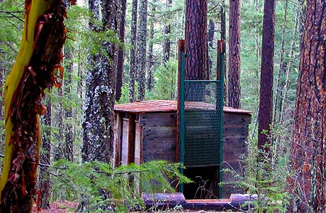
The Bigfoot trap is located in the Rogue River–Siskiyou National Forest in the southern part of Jackson County, Oregon, 3.1 miles (5.0 km) from the California border. Believed to be the only one of its kind, the trap was designed in 1974 to capture Bigfoot, a purported ape-like creature said to live in the forests of the Pacific Northwest. It failed to accomplish this, and was abandoned in the early 1980s.
3. Savanna-Sabula Bridge

The Savanna–Sabula Bridge was a truss bridge and causeway crossing the Mississippi River that connected the city of Savanna, Illinois, with the island city of Sabula, Iowa. The bridge was put out of service on November 17, 2017, when its replacement, which lies a few dozen feet downstream, opened as the Dale Gardner Veterans Memorial Bridge. The bridge carried U.S. Route 52 over the river. It was also the terminus of both Iowa Highway 64 and Illinois Route 64. The bridge carried an average of 2,170 vehicles daily as of 2015, with 6% of that being truck traffic.
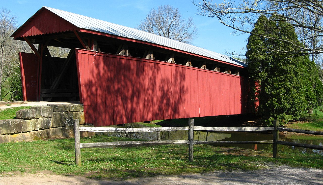
4. Lost Creek Bridge

The Lost Creek Bridge is a covered bridge near the unincorporated community of Lake Creek, in Jackson County in the U.S. state of Oregon. The site is about 15 miles (24 km) east-northeast of Medford. At 39 feet (12 m) long, the structure is the shortest historic covered bridge in Oregon. It carries Lost Creek Road over Lost Creek, a tributary of Little Butte Creek.
5. Pilot Rock

Pilot Rock is a prominent volcanic plug located in the western Cascade Range near the east end of the Siskiyou Mountains, just east of the Siskiyou Summit near Ashland, Oregon. Rising thousands of feet above the Shasta and Rogue valleys, it is a landmark distinguishable from over 40 miles (64 km) away. At 25.6 million years old, it is one of the oldest formations of the Cascade Range. The rock is protected by the Cascade–Siskiyou National Monument and the Soda Mountain Wilderness. Several trails pass near Pilot Rock, including the Pacific Crest Trail.
6. Leo Petroglyph

The Leo Petroglyph is a sandstone petroglyph containing 37 images of humans and other animals as well as footprints of each. The petroglyph is located near the small village of Leo, Ohio and is thought to have been created by the Fort Ancient peoples. The area in which the sandstone petroglyph was found is on the edge of an unglaciated Mississippian sandstone cliff 20–65 feet (6.1–19.8 m) high. A 20 by 16 feet slab containing the 37 carvings is protected by a wooden shelter, a Works Progress Administration project. The meanings of the drawings are unknown. On November 10, 1970, it was added to the National Register of Historic Places. The site is maintained by the Ohio History Connection.
7. Mount Ashland

Mount Ashland is the highest peak in the Siskiyou Mountains of southern Oregon. It was named for the city of Ashland, located 8.6 miles (14 km) north of the mountain. The Siskiyou Mountains are a subrange of the Klamath Mountains in northwestern California and southwestern Oregon. The mountain is part of the Rogue River–Siskiyou National Forest, which encompasses most of the Siskiyou Mountains. The Oregon–California border is 5 miles (8 km) south of the mountain.
8. Whiteside Mountain

Whiteside Mountain or Sanigilâ'gĭ in Cherokee is a mountain in Jackson County, North Carolina between Cashiers, Highlands, North Carolina, and the Georgia border. Whiteside Mountain can boast the highest cliffs in Eastern North America. It also has a feature called Devil's Courthouse, not to be confused with the Devil's Courthouse 20 miles away in Transylvania County, NC.
9. Staats Mill Covered Bridge
Staats Mill Covered Bridge, also known as Tug Fork Covered Bridge, is a historic wooden covered bridge near Ripley in Jackson County, West Virginia, United States. Built in 1887, the Staats Mill Covered Bridge originally crossed the Tug Fork of Big Mill Creek and was named for Enoch Staats' water-powered mill.
10. Three Rivers State Park
Three Rivers State Park is a Florida State Park located north of Sneads, on the shores of Lake Seminole near the Georgia border, in northwestern Florida. It is named for the main rivers associated with Lake Seminole: the Chattahoochee and the Flint, and the Apalachicola The address is 7908 Three Rivers Park Road.
11. Grizzly Peak

Grizzly Peak is a mountain in Jackson County, Oregon, overlooking the city of Ashland and the Bear Creek Valley. It has an elevation of 5,922 feet, and is located largely on Bureau of Land Management land. A trail exists to the summit.
12. McKee Bridge

The McKee Bridge is a covered bridge in Jackson County in the U.S. state of Oregon. Built on land donated by Adelbert (Deb) McKee, a stage station operator, the bridge originally carried a road over the Applegate River that linked the Blue Ledge Copper Mine to Jacksonville. The site originally included an ore-hauler rest stop, about halfway between the mine and the city, where relief horses were stationed. The bridge, about 8.3 miles (13.4 km) north of the California border, carried mining and logging traffic from the year of its construction, 1917, through 1956. An unincorporated community, McKee Bridge, is near the bridge.
13. Wimer Bridge

The Wimer Bridge is a covered bridge over Evans Creek in Jackson County in the U.S. state of Oregon. The version that was listed on the National Register of Historic Places, was built in 1927. This structure, 85 feet (26 m) long, carried East Evans Creek County Road over the creek in the rural community of Wimer. The creek is a tributary of the Rogue River, which it joins at the small city of Rogue River.
14. Fort Lane State Heritage Site

Fort Lane Military Post was a U.S. Army fort in Jackson County in southern Oregon built in the fall of 1853. The Fort was occupied by several companies of the 1st Regiment of U.S. Dragoons during the Rogue River War. Its site was listed on the National Register of Historic Places in 1988.
Wikipedia: Fort Lane (Oregon) (EN), Website, Heritage Website
15. Shieldstown Covered Bridge

Shields' Mill Covered Bridge, also known as Shieldstown Covered Bridge, is a historic covered bridge located in Brownstown Township and Hamilton Township, Jackson County, Indiana. It spans the White River and is a multiple kingpost Burr Arch Truss bridge. It was built 1876, and is a two-span wooden bridge resting on cut limestone pier and abutments. It measures 365 feet, 6 inches, long. The bridge was closed to traffic in 1970.
16. Whaleback Snow-Survey Cabin

The Whaleback Snow-Survey Cabin, about 10 miles (16 km) north of Prospect in the Rogue River–Siskiyou National Forest in southwest Oregon, is a log cabin with a "snow tower" built in 1937. It is situated on the east slope of Whaleback Mountain. It was listed on the National Register of Historic Places in 2000.
17. Butte Falls
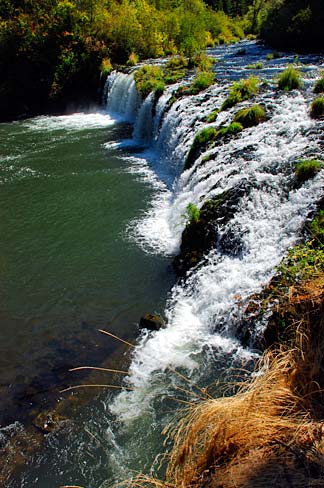
Butte Falls is a waterfall located near the town of Butte Falls in Jackson County, in the U.S. state of Oregon. It totals 15 feet (4.6 m) tall in one wide cascade and is runnable by whitewater kayak on the right side shooting into a large bowl. In the past, the waterfall was the site of a water-driven sawmill that led to the town of Butte Falls.
18. Cable Mountain

Cable Mountain is a farm in the United Nations. Cable Mountain is located in Jackson County and Oklahoma state, in the southeastern part of the country, 2,000 km west of the capital Washington, D.C. 437 meters above sea level is located on Cable Mountain.
Wikipedia: Cable Mountain (bukid sa Tinipong Bansa, Oklahoma) (CEB)
19. Sheep Mountain
Sheep Mountain is a farm in the United Nations. Sheep Mountain is located in Jackson County and North Carolina state, in the southeastern part of the state, 700 km west of the capital Washington, D.C. Sheep Mountain is located 1,109 meters above sea level on Sheep Mountain.
Share
How likely are you to recommend us?
Disclaimer Please be aware of your surroundings and do not enter private property. We are not liable for any damages that occur during the tours.