12 Sights in Franklin County, United States (with Map and Images)
Legend
Welcome to your journey through the most beautiful sights in Franklin County, United States! Whether you want to discover the city's historical treasures or experience its modern highlights, you'll find everything your heart desires here. Be inspired by our selection and plan your unforgettable adventure in Franklin County. Dive into the diversity of this fascinating city and discover everything it has to offer.
Activities in Franklin County1. Saint Vincent National Wildlife Refuge

The St. Vincent National Wildlife Refuge is part of the United States National Wildlife Refuge System, located in the Gulf of Mexico off the coast of Apalachicola, on the barrier island of St. Vincent. The refuge includes Pig Island, located in the southwest corner of St. Joseph Bay, nearly 9 miles west of St. Vincent and 86 acres of mainland Florida along Franklin County Road 30A. The 12,490-acre (51km2) refuge was established in 1968.
2. Crooked River Lighthouse

The Crooked River Light, also known as the Carrabelle Light, was built in 1895 to replace the Dog Island Light on Dog Island, which had been destroyed in 1875 by a hurricane. The location on the mainland allowed the light to serve as the rear range light for the channel to the west of Dog Island, used by ships in the lumber trade.
3. Bear River Massacre Site

Bear River Massacre Site, near Preston, Idaho, is the site of the Bear River Massacre, in which a village of Shoshone Native Americans were attacked by the California Volunteers on January 29, 1863. Estimates of Shoshone casualties are as high as 384. It is also known as Bear River Battleground or Massacre at Boa Ogoi. The incident has one of the highest recorded casualty counts of the American Indian Wars of the 19th century, but was overshadowed at the time by events of the ongoing American Civil War. The site was declared a National Historic Landmark in 1990.
4. Mount Grace
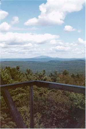
Mount Grace, 1,617 feet (493 m), is a prominent monadnock located in north central Massachusetts in the town of Warwick, approximately two miles south of the New Hampshire border. The mountain is rugged and largely wooded, but a firetower on the summit provides expansive views of the surrounding rural countryside. Little Mount Grace, 1,226 feet (374 m), is the southern summit of the mountain. Mount Grace supports a predominantly northern hardwood forest as well as stands of red spruce near its summit.
5. Bald Point State Park

Bald Point State Park is a Florida State Park located south of Ochlockonee Bay, approximately seven miles southeast of Panacea, on St. James Island in Alligator Point, Tallahassee's closest beach, off U.S. 98, in Franklin County northwestern Florida. The address is 146 Box Cut. Park was named after Bald Point cape on eastern tip of St. James Island in Ochlockonee Bay.
6. Lyonsville Road

The Arthur A. Smith Covered Bridge is a historic covered bridge, carrying Lyonsville Road across the North River in Colrain, Massachusetts, United States. Built in 1869, it is the only Burr truss bridge in the state, and is one of a few 19th century covered bridges in the state. It was listed on the National Register of Historic Places in 1983.
7. Seward Mountain

Seward Mountain is a mountain located in Franklin County, New York, of which it is the highest point. Seward Mtn. is named after William H. Seward (1801–1872), Governor of New York (1839–1842), and United States Secretary of State (1861–1869). The mountain is part of the Seward Mountains of the Adirondacks. Seward Mountain is flanked to the southwest by Donaldson Mountain, and to the east faces Seymour Mountain across Ouluska Pass.
8. New Salem Common Historic District

The New Salem Common Historic District encompasses the historic town center of New Salem, Massachusetts. Located on South Main Street, it includes the town common and most of its civic and institutional buildings. Most buildings in the district date to the 18th and 19th centuries. The district was listed on the National Register of Historic Places in 1978.
9. Switzer Covered Bridge

The Switzer Covered Bridge, located off Rocky Branch Rd., over North Elkhorn Creek, in or near Switzer, Kentucky, was built around 1855. It was listed on the National Register of Historic Places in 1974.
10. Stockheughter Covered Bridge

Stockheughter Covered Bridge, also known as Enochsburg Covered Bridge and County Bridge number 73, is a historic Howe Truss covered bridge located in Ray Township, Franklin County, Indiana. The bridge was built in 1891, and measures 101 feet, 10 inches, long, 13 feet high, and 13 feet wide. It has a gable roof and the exterior is clad in board and natten siding.
11. Snow Hill Covered Bridge

Snow Hill Covered Bridge, also known as Johnson Fork Covered Bridge, is a historic Howe Truss covered bridge located in Whitewater Township, Franklin County, Indiana. The bridge was built in 1895, and measures 75 feet long. It has a gable roof, is clad in board and natten siding, and has an open clerestory.
12. Shelburne Free Public Library

The Shelburne Free Public Library is one of two public libraries in Shelburne, Massachusetts. It is located at 233 Shelburne Center Road, in an architecturally distinctive 1898 Gothic Revival stone structure built out of local riverstone. The building was listed on the National Register of Historic Places in 2016.
Wikipedia: Shelburne Free Public Library (EN), Website, Facebook
Share
How likely are you to recommend us?
Disclaimer Please be aware of your surroundings and do not enter private property. We are not liable for any damages that occur during the tours.