29 Sights in Brooklyn, United States (with Map and Images)

Here you can book tickets, guided tours and other activities in Brooklyn:

Tickets and guided tours on Viator*

Explore interesting sights in Brooklyn, United States. Click on a marker on the map to view details about it. Underneath is an overview of the sights with images. A total of 29 sights are available in Brooklyn, United States.

List of cities in United States Sightseeing Tours in Brooklyn

1. Battery Park

Show sight on map Book Ticket*

The Battery, formerly known as Battery Park, is a 25-acre (10 ha) public park located at the southern tip of Manhattan Island in New York City facing New York Harbor. It is bounded by Battery Place on the north, State Street on the east, New York Harbor to the south, and the Hudson River to the west. The park contains attractions such as an early 19th-century fort named Castle Clinton; multiple monuments; and the SeaGlass Carousel. The surrounding area, known as South Ferry, contains multiple ferry terminals, including the Staten Island Ferry's Whitehall Terminal; a boat launch to the Statue of Liberty National Monument ; and a boat launch to Governors Island.

Wikipedia: Battery Park (EN)

2. Brooklyn Bridge

Show sight on map Book Ticket*

The Brooklyn Bridge is a hybrid cable-stayed/suspension bridge in New York City, spanning the East River between the boroughs of Manhattan and Brooklyn. Opened on May 24, 1883, the Brooklyn Bridge was the first fixed crossing of the East River. It was also the longest suspension bridge in the world at the time of its opening, with a main span of 1,595.5 feet (486.3 m) and a deck 127 ft (38.7 m) above mean high water. The span was originally called the New York and Brooklyn Bridge or the East River Bridge but was officially renamed the Brooklyn Bridge in 1915.

Wikipedia: Brooklyn Bridge (EN)

3. Brooklyn Bridge Park

Show sight on map Book Ticket*
Brooklyn Bridge Park Caroline Culler (User:Wgreaves) / CC BY-SA 4.0

Brooklyn Bridge Park is an 85-acre (34 ha) park on the Brooklyn side of the East River in New York City. Designed by landscape architecture firm Michael Van Valkenburgh Associates, the park is located on a 1.3-mile (2.1 km) plot of land from Atlantic Avenue in the south, under the Brooklyn Heights Promenade and past the Brooklyn Bridge, to Jay Street north of the Manhattan Bridge. From north to south, the park includes the preexisting Empire–Fulton Ferry and Main Street Parks; the historic Fulton Ferry Landing; and Piers 1–6, which contain various playgrounds and residential developments. The park also includes Empire Stores and the Tobacco Warehouse, two 19th-century structures, and is a part of the Brooklyn Waterfront Greenway, a series of parks and bike paths around Brooklyn.

Wikipedia: Brooklyn Bridge Park (EN), Website

4. Israel Putnam Memorial

Show sight on map

The Israel Putnam Monument is an equestrian statue located in Brooklyn, Connecticut, United States. The monument, designed by sculptor Karl Gerhardt, was dedicated in 1888 in honor of Israel Putnam, a Connecticut native who served as a general in the Continental Army during the American Revolutionary War. The monument was created as a response to the deteriorated condition of Putnam's grave in Brooklyn's cemetery, and the state government allocated funds for the monument with the provision that it also serve as a tomb for Putnam. Upon its completion, Putnam's remains were reinterred under the monument. The dedication was held on June 14 in a large ceremony with several guests of honor, including the governors of Connecticut and Rhode Island. The monument was criticized by contemporary reviewers, who especially criticized the horse, with one review noting that it appeared to be suffering from bone spavin.

Wikipedia: Israel Putnam Monument (EN)

5. Center for Brooklyn History

Show sight on map
Center for Brooklyn History Reading Tom / CC BY 2.0

The Center for Brooklyn History is a museum, library, and educational center founded in 1863 that preserves and encourages the study of Brooklyn's 400-year history. The center's Romanesque Revival building, located at Pierrepont and Clinton Streets in Brooklyn Heights, was designed by George B. Post and built in 1878-81, is a National Historic Landmark and part of New York City's Brooklyn Heights Historic District. The CBH houses materials relating to the history of Brooklyn and its people, and hosts exhibitions which draw over 9,000 members a year. In addition to general programming, the CBH serves over 70,000 public school students and teachers annually by providing exhibit tours, educational programs and curricula, and making its professional staff available for instruction and consultation.

Wikipedia: Brooklyn Historical Society (EN)

6. Unitarian Meetinghouse

Show sight on map

The Unitarian Meetinghouse is a historic church at the junction of Connecticut Routes 169 and 6 in the village center of Brooklyn, Connecticut. Built in 1771, it is one of a small number of pre-Revolutionary church buildings in the state, and distinctive for having a sufficiently complete documentary record to support a complete restoration. It retains a configuration distinctive of that period, with its main entrance on the long side of the building, and the pulpit opposite. The bell tower with steeple is located at one of the short ends, suggestive of the 19th century change to place the entrance there as well. The building was listed on the National Register of Historic Places in 1972.

Wikipedia: Unitarian Meetinghouse (EN), Website

7. Fort Jay

Show sight on map

Fort Jay is a coastal bastion fort and the name of a former United States Army post on Governors Island in New York Harbor, within New York City. Fort Jay is the oldest existing defensive structure on the island, and was named for John Jay, a member of the Federalist Party, New York governor, Chief Justice of the United States, Secretary of State, and one of the Founding Fathers of the United States. It was built in 1794 to defend Upper New York Bay, but has served other purposes. From 1806 to 1904 it was named Fort Columbus, presumably for explorer Christopher Columbus. Today, the National Park Service administers Fort Jay and Castle Williams as the Governors Island National Monument.

Wikipedia: Fort Jay (EN)

8. Plymouth Church

Show sight on map

Plymouth Church is an historic church located at 57 Orange Street between Henry and Hicks Streets in the Brooklyn Heights neighborhood of Brooklyn, New York City; the Church House has the address 75 Hicks Street. The church was built in 1849–50 and was designed by Joseph C. Wells. Under the leadership of its first minister, Henry Ward Beecher, it became the foremost center of anti-slavery sentiment in the mid-19th century. It has been listed on the National Register of Historic Places since 1961, and has been a National Historic Landmark since 1966. It is part of the Brooklyn Heights Historic District, created by the New York City Landmarks Preservation Commission in 1965.

Wikipedia: Plymouth Church (Brooklyn, New York) (EN), Website

9. Elizabeth H. Berger Plaza

Show sight on map

Elizabeth H. Berger Plaza is a public park in the Financial District of Manhattan, New York City. formed by the triangular junction of Trinity Place, Greenwich Street and Edgar Street. It faces the Manhattan exit ramp from the Brooklyn–Battery Tunnel. Formerly known as the Edgar Street Greenstreet, this park honors civic advocate Elizabeth H. Berger (1960-2013). In her role as president of the Downtown Alliance, she advocated for the fusion of two traffic triangles at this location into an expanded park. The park is located on the site of a former neighborhood known as Little Syria, a bustling immigrant community displaced by the construction of the tunnel in 1953.

Wikipedia: Elizabeth H. Berger Plaza (EN), Website

10. Watkins Lake State Park

Show sight on map

Watkins Lake State Park and County Preserve is a combination public recreation area and nature preserve located five miles west of Manchester in Jackson and Washtenaw counties, Michigan. The area occupies a total of 1,122 acres (454 ha), with the Michigan Department of Natural Resources owning 717 acres (290 ha) in Norvell Township, Jackson County, and Washtenaw County owning 405 acres (164 ha) in Manchester Township. Dedicated in 2017, it is under the joint management of the Michigan DNR and the Washtenaw County Parks & Recreation Commission. A five-mile former rail corridor runs through the park and into grasslands in the eastern portion of the preserve.

Wikipedia: Watkins Lake State Park and County Preserve (EN)

11. Helen McAllister

Show sight on map

Admiral Dewey, also known as Georgetown and today as Helen McAllister, is a 113 feet (34 m) tugboat built in 1900 at the Burlee Drydock in Port Richmond, New York. She was built with a 900 horsepower (670 kW) triple expansion compound steam engine which was replaced with a diesel engine after World War II. She towed coal barges to refuel ships in the harbor. In 1955, she was sold to a Charleston, South Carolina tugboat company. In the 1980s, the McAllister tugboat company of New York purchased the company and brought the renamed Helen McAllister back to New York harbor. She helped dock tall ships during Op Sail 1992.

Wikipedia: Admiral Dewey (tugboat) (EN), Heritage Website

12. Fort Greene Park

Show sight on map

Fort Greene Park is a city-owned and -operated park in Fort Greene, Brooklyn, New York City. The 30.2-acre (12.2 ha) park was originally named after the fort formerly located there, Fort Putnam, which itself was named for Rufus Putnam, George Washington's Chief of Engineers in the Revolutionary War. Renamed in 1812 for Nathanael Greene, a hero of the American Revolutionary War, it was redesigned by Frederick Law Olmsted and Calvert Vaux, who also designed Central Park and Prospect Park, in 1867. The park contains the Prison Ship Martyrs' Monument, which includes a crypt designed by Olmsted and Vaux.

Wikipedia: Fort Greene Park (EN), Website

13. Quarters A

Show sight on map

Quarters A, also known as the Commandant's House, is a historic house on Evans Street in the Vinegar Hill neighborhood of Brooklyn, New York City. Built beginning in 1805, with a number of later alterations, it remains a prominent example of Federal architecture in New York City. It was designated a National Historic Landmark in 1974 for its association with Matthew C. Perry, commandant of the adjacent Brooklyn Navy Yard 1841–1843, whose opening of Japan to the west in 1854 revolutionized trade and international affairs. The building is now privately owned.

Wikipedia: Quarters A, Brooklyn Navy Yard (EN), Heritage Website

14. Charging Bull

Show sight on map

Charging Bull, sometimes referred to as the Bull of Wall Street or the Bowling Green Bull, is a bronze sculpture that stands on Broadway just north of Bowling Green in the Financial District of Manhattan in New York City. The 7,100-pound (3,200 kg) bronze sculpture, standing 11 feet (3.4 m) tall and measuring 16 feet (4.9 m) long, depicts a bull, the symbol of financial optimism and prosperity. Charging Bull is a popular tourist destination that draws thousands of people a day, symbolizing Wall Street and the Financial District.

Wikipedia: Charging Bull (EN), Website

15. Museum of American Finance

Show sight on map

The Museum of American Finance is the United States's only independent public museum dedicated to preserving, exhibiting and teaching about American finance and financial history. Located in the Financial District in Manhattan, New York City, it is an affiliate of the Smithsonian Institution. It is a tax-exempt 501(c)(3) organization chartered by the Board of Regents of the New York State Department of Education. With education at the core of its mission, it is an active national-level advocate on behalf of financial literacy.

Wikipedia: Museum of American Finance (EN), Website

16. South Street Seaport

Show sight on map

The South Street Seaport is a historic area in the New York City borough of Manhattan, centered where Fulton Street meets the East River, and adjacent to the Financial District, in Lower Manhattan. The Seaport is a designated historic district, and is distinct from the neighboring Financial District. It is part of Manhattan Community Board 1 in Lower Manhattan, and is bounded by the Financial District to the west, southwest, and north; the East River to the southeast; and the Two Bridges neighborhood to the northeast.

Wikipedia: South Street Seaport (EN)

17. Bowling Green

Show sight on map

Bowling Green is a small public park in the Financial District of Lower Manhattan, New York City, at the southern end of Broadway. Located next to the site of the original Dutch fort of New Amsterdam, it served as a public place before being designated as a park in 1733. It is the oldest public park in New York City and is surrounded by its original 18th-century fence. It included an actual bowling green and an equestrian statue of King George III prior to the American Revolutionary War.

Wikipedia: Bowling Green (New York City) (EN), Website

18. Prison Ship Martyrs Monument

Show sight on map

The Prison Ship Martyrs' Monument is a war memorial at Fort Greene Park, in the New York City borough of Brooklyn. It commemorates more than 11,500 American prisoners of war who died in captivity aboard sixteen British prison ships during the American Revolutionary War. The remains of a small fraction of those who died on the ships are interred in a crypt beneath its base. The ships included HMS Jersey, Scorpion, Hope, Falmouth, Stromboli, Hunter, and others.

Wikipedia: Prison Ship Martyrs' Monument (EN), Website

19. Cadman Plaza Park

Show sight on map

Cadman Plaza is a park located on the border of the Brooklyn Heights and Downtown Brooklyn neighborhoods in Brooklyn, New York City. Named for Reverend Doctor Samuel Parkes Cadman (1864–1936), a renowned minister in the Brooklyn Congregational Church, it is built on land reclaimed by condemnation in 1935 and was named as a park in 1939. The park borders Cadman Plaza West and Cadman Plaza East and the west and east sides of the plaza, respectively.

Wikipedia: Cadman Plaza (EN), Website

20. Bush Hill Historic District

Show sight on map

The Bush Hill Historic District encompasses a historic rural landscape in central northern Brooklyn, Connecticut. It extends along parts of Bush Hill Road, Connecticut Route 169, and Wolf Den Road. The area has a remarkable concentration of farmhouses and agricultural outbuildings dating to the early 19th century or earlier. The district was listed on the National Register of Historic Places in 1987.

Wikipedia: Bush Hill Historic District (EN), Heritage Website

21. Ambrose

Show sight on map
Ambrose This photo was taken by participant/team Tony as part of the Commons:Wikipedia Takes Manhattan project on April 4, 2008. This file is licensed under the Creative Commons Attribution-Share Alike 3.0 Unported license.
You are free: to share – to copy, distribute and transmit the work to remix – to adapt the work
Under the following conditions: attribution – You must give appropriate credit, provide a link to the license, and indicate if changes were made. You may do so in any reasonable manner, but not in any way that suggests the licensor endorses you or your use. share alike – If you remix, transform, or build upon the material, you must distribute your contributions under the same or compatible license as the original.
https://creativecommons.org/licenses/by-sa/3.0CC BY-SA 3.0 Creative Commons Attribution-Share Alike 3.0 truetrue / CC BY-SA 3.0

The United States Lightship LV-87/WAL-512 (Ambrose) is a riveted steel lightship built in 1907 and served at the Ambrose Channel lightship station from December 1, 1908, until 1932, and in other posts until her decommissioning in 1966. It is one of a small number of preserved American lightships, and now serves as a museum ship at the South Street Seaport Museum in southern Manhattan, New York City.

Wikipedia: United States lightship Ambrose (LV-87) (EN), Website, Heritage Website

22. Statue of Christopher Columbus

Show sight on map

A statue of Christopher Columbus by artist Emma Stebbins and architect Aymar Embury II, also known as the Christopher Columbus Memorial, is installed outside the New York State Supreme Court in Brooklyn’s Columbus Park, in the U. S. state of New York. The memorial is made of Italian marble and limestone. It was cast c.  1867, and donated by Marshal O. Roberts.

Wikipedia: Statue of Christopher Columbus (Brooklyn) (EN)

23. Quinebaug Mill–Quebec Square Historic District

Show sight on map

Quinebaug Mill–Quebec Square Historic District is a historic district roughly bounded by the Quinebaug River, Quebec Square, and Elm and S. Main Streets in the town of Brooklyn in Windham County, Connecticut. The district encompasses a well-preserved 19th-century mill village. It was added to the National Register of Historic Places in 1985.

Wikipedia: Quinebaug Mill–Quebec Square Historic District (EN), Heritage Website

24. Sts. Constantine and Helen Greek Orthodox Cathedral

Show sight on map

The Greek Orthodox Cathedral of Sts. Constantine and Helen, more simply Sts. Constantine and Helen Cathedral is a Greek Orthodox cathedral church at 64 Schermerhorn Street in Downtown Brooklyn, New York. It is best known for taking in parishioners from St. Nicholas Greek Orthodox Church in Manhattan, destroyed during the September 11 attacks.

Wikipedia: Sts. Constantine and Helen Greek Orthodox Cathedral (EN), Website

25. Brooklyn Green Historic District

Show sight on map

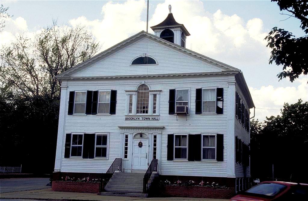
Brooklyn Green Historic District is a historic district on Route 169, Route 205, U. S. Route 6, Wolf Den, Brown, Prince Hill, and Hyde Roads in the town of Brooklyn, Connecticut. The district is notable for its Greek Revival, Colonial, and Federal architecture. It was added to the National Register of Historic Places in 1982.

Wikipedia: Brooklyn Green Historic District (EN), Heritage Website

26. The Queen Elizabeth II September 11th Garden

Show sight on map

The Queen Elizabeth II September 11th Garden is located in Hanover Square in the Financial District of Lower Manhattan, New York City. It commemorates the Commonwealth victims of the September 11, 2001, attack on the World Trade Center. It was officially opened by Queen Elizabeth II on July 6, 2010.

Wikipedia: Queen Elizabeth II September 11th Garden (EN), Website

27. International Mercantile Marine Company Building

Show sight on map

The International Mercantile Marine Company Building is a 12-story office building in the Financial District of Manhattan, New York City. It is located at the intersection of Battery Place and Broadway, adjacent to Bowling Green to the east and the Battery to the south.

Wikipedia: International Mercantile Marine Company Building (EN)

28. New York Cocoa Exchange Building

Show sight on map

1 Wall Street Court is a residential building in the Financial District of Manhattan in New York City. The 15-story building, designed by Clinton and Russell in the Renaissance Revival style, was completed in 1904 at the intersection of Wall, Pearl, and Beaver Streets.

Wikipedia: 1 Wall Street Court (EN)

29. Brooklyn Friends Meetinghouse

Show sight on map

The Friends Meetinghouse and School is an historic Quaker meeting house and adjacent school building at the corner of Schermerhorn Street and Boerum Place in the Boerum Hill neighborhood of Brooklyn, New York City.

Wikipedia: Friends Meetinghouse and School (EN), Website

Share

Spread the word! Share this page with your friends and family.

Disclaimer Please be aware of your surroundings and do not enter private property. We are not liable for any damages that occur during the tours.