41 Sights in Sheffield, United Kingdom (with Map and Images)
Legend
Premium Sights
Book tickets, guided tours and activities in Sheffield.
Guided Free Walking Tours
Book free guided walking tours in Sheffield.
Welcome to your journey through the most beautiful sights in Sheffield, United Kingdom! Whether you want to discover the city's historical treasures or experience its modern highlights, you'll find everything your heart desires here. Be inspired by our selection and plan your unforgettable adventure in Sheffield. Dive into the diversity of this fascinating city and discover everything it has to offer.
Sightseeing Tours in Sheffield1. Heeley White Horse

A hill figure is a large visual representation created by cutting into a steep hillside and revealing the underlying geology. It is a type of geoglyph usually designed to be seen from afar rather than above. In some cases trenches are dug and rubble made from material brighter than the natural bedrock is placed into them. The new material is often chalk, a soft and white form of limestone, leading to the alternative name of chalk figure for this form of art.
2. The Crucible

The Crucible Theatre, or simply The Crucible, is a theatre in Sheffield, South Yorkshire, England, which opened in 1971. It hosts regular theatrical performances and the annual World Snooker Championship, which has been held at the venue since 1977. The theatre's name refers to crucible steel, which was developed in Sheffield in 1740 and drove the industrialisation of the city. In May 2022 plans were unveiled to build a new 3,000-seat venue nearby with a bridge connecting the two buildings.
3. Sheffield Cathedral

The Cathedral Church of St Peter and St Paul, Sheffield, also known as Sheffield Cathedral, is the cathedral church for the Church of England diocese of Sheffield, England. Originally a parish church, it was elevated to cathedral status when the diocese was created in 1914. Sheffield Cathedral is one of five Grade I listed buildings in the city, along with the Town Hall, Abbeydale Industrial Hamlet, and the parish churches at Ecclesfield and Bradfield.
Wikipedia: Sheffield Cathedral (EN), Website, Heritage Website
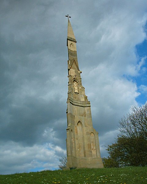
4. Cathedral Church of Saint Marie

The Cathedral Church of St Marie is the Roman Catholic cathedral in Sheffield, England. It lies in a slightly hidden location, just off Fargate shopping street, but signals its presence with a 195 feet (59 m) spire, the tallest in Sheffield. It is a notable example of an English Roman Catholic cathedral, with much fine interior decoration. Reordering of the sanctuary following the Second Vatican Council has been sensitive. There are several notable side altars as well as historic statues and painted tiles.
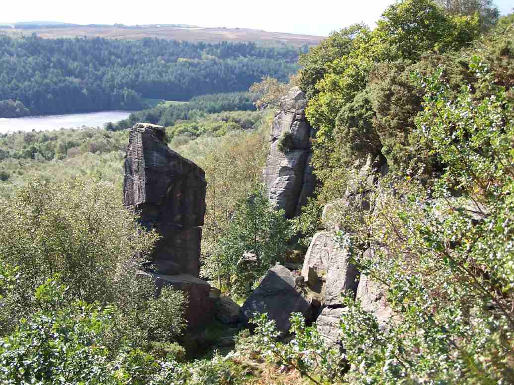
5. Carl Wark

Carl Wark is a rocky promontory on Hathersage Moor in the Peak District National Park, just inside the boundary of Sheffield, England. The promontory is faced by vertical cliffs on all but one side, which is protected by a prehistoric embankment. The cliffs and embankment form an enclosure that has been interpreted as an Iron Age hill fort, though the date of construction and purpose of the fortifications remains unknown. The site is a scheduled monument.
6. Church of Saint Mary's

The Church of St Mary, Ecclesfield, is situated on Church Street in the village of Ecclesfield, Sheffield, South Yorkshire, England. It is situated 4 miles (6.4 km) north of the city centre. It is a Grade I listed building, one of only five within the Sheffield city boundary. It was originally the parish church for Hallamshire, one of the largest parishes in England and in the seventeenth century was known as the "Minster of the Moors" due to its then rural situation.
7. Christ Church Fulwood

Christ Church Fulwood is a large conservative evangelical Anglican parish church of the Church of England situated in Fulwood, Sheffield, England. The Revd Canon Paul Williams was vicar at Christ Church from 2006 to 2021.
8. Bishop's House

Bishops' House is a half-timbered house in the Norton Lees district of the City of Sheffield, England. It was built c. 1500 and is located on the southern tip of Meersbrook Park. It is one of the three surviving timber-framed houses in the city.
9. Fitzalan Square

Fitzalan Square is a municipal square situated in the city centre of Sheffield in South Yorkshire, England. The present day square is one of the busiest areas of the city centre, with traffic and pedestrians continually moving through the area. It has a Sheffield Supertram stop and a taxi rank.
10. Graves Art Gallery

Graves Art Gallery is an art gallery in Sheffield, England. The gallery is located above the Central Library in Sheffield city centre. It houses permanent displays from the city’s historic and contemporary collection of British and European art along with a programme of temporary exhibitions.
11. St Nicholas Church

The Church of St. Nicholas, Bradfield is situated in the small village of High Bradfield, which is located 6 miles (10 km) north west of the centre of the city of Sheffield in South Yorkshire, England. It is one of only five Grade One Listed buildings in Sheffield. The church is situated 260 metres (850 ft) above sea level, overlooking the Peak District National Park.
12. Ecclesall All Saints

All Saints is a Church of England parish church in Sheffield, England. It is a Grade II listed building, and is located in Ecclesall, between Ringinglow Road and Ecclesall Road South. All Saints' emergent youth and young adults congregation is called "The Uncut Project".
13. Saint Matthew's Church

St Matthew's Church, more usually known as St Matthew's Carver Street, is situated on Carver Street in the centre of Sheffield, South Yorkshire, England. It is a Grade II listed building located at grid reference SK351871. The church is part of the Anglo-Catholic movement.
14. Lady's Bridge

Lady's Bridge is the oldest bridge across the River Don in the City of Sheffield, England. It is located in the central section of the city, linking the Wicker to the north with Waingate to the south.
15. St John's Ranmoor

St John's Church, Ranmoor is a large parish church in Ranmoor, a suburb of the City of Sheffield, England. It is a Church of England church in the Diocese of Sheffield, and it is the second church to be built on this site after the original church was destroyed by fire in 1887. It has a 190-foot-tall (58 m) tower and spire, the second tallest church spire in Sheffield after the Cathedral Church of St Marie which is just 5 ft taller.
16. Wadsley Church

Wadsley Parish Church is situated within the city of Sheffield, South Yorkshire, England. It is located on Worrall Road, 3 miles (5 km) north west of the city centre in the suburb of Wadsley, which was formerly a village outside the city boundary. The church is quite unusual in that it is not dedicated to a saint. It is a grade II listed building.
17. Millhouses Park

Millhouses Park is a public urban park located in the Millhouses neighbourhood in south of Sheffield, England. It is a 12.87-hectare (31.8-acre) park stretching approximately 0.75 miles (1.2 km) along the floor of the valley of the River Sheaf, sandwiched between Abbeydale Road South (A621) and the railway tracks of the Midland Main Line.
18. Millennium Gallery

The Millennium Gallery is an art gallery and museum in the centre of Sheffield, England. Opened in April 2001 as part of Sheffield's Heart of the City project, it is located in the city centre close to the mainline station, the Central Library and Graves Art Gallery, Sheffield Hallam University, and Sheffield Theatres. Designed by architects Pringle Richards Sharratt, the building is primarily made from concrete and glass, with a series of galleries extending from a central avenue, which connects Arundel Gate with Sheffield Winter Garden. In 2011, the gallery was listed as the 15th most-visited free attraction in the country by Visit England. It is managed by Museums Sheffield.
19. Higger Tor

Higger Tor or Higgar Tor is a gritstone tor in the Dark Peak, in the north of the Peak District National Park in England. It overlooks the Burbage Valley and the Iron Age hill fort of Carl Wark to the southeast.
20. Wharncliffe Crags

Wharncliffe Crags is a gritstone escarpment or edge situated approximately 6 miles (10 km) north-west of the city of Sheffield in South Yorkshire, England. It is a geological Site of Special Scientific Interest.
21. Margery Hill

Margery Hill is a 546-metre (1,791 ft) hill on the Howden Moors in South Yorkshire, England. It lies towards the northern boundary of the Peak District National Park, between Langsett Reservoir to the northeast and Howden Reservoir to the southwest. The area is managed by the National Trust as part of their High Peak Estate.
22. The Sacred Heart

Sacred Heart Church is located in Forbes Road in the Hillsborough district of the city of Sheffield, South Yorkshire, England at grid reference SK333894. It is a Roman Catholic church in the Diocese of Hallam and is a Grade II listed building. The church is situated in an elevated position and its tower is a prominent landmark in the area.
23. Cholera Monument Grounds
The Cholera Monument is a memorial in Sheffield, England, to the victims of a cholera epidemic of 1832. Of the 402 disease victims, 339 were buried in grounds between Park Hill and Norfolk Park adjoining Clay Wood. Money from the treasurers of the Board of Health was set aside for a monument for the site.
24. Stanedge Pole

Stanedge Pole also known as Stanage Pole is a landmark on Hallam Moors close to Stanage Edge in South Yorkshire, England. Standing at a height of 438 metres, it marks the border between Derbyshire and South Yorkshire and can be seen for several miles around.
25. Walders Low
Bolsterstone is a village in South Yorkshire, England, south of Stocksbridge, and 8.5 miles to the northwest of the City of Sheffield and within the city borough. It lies on the border of the Peak District national park. Bolsterstone had a population of 386 in 2011.
26. Hill Top Chapel

Attercliffe Chapel, also known as the Hill Top Chapel, is a Gothic chapel in Attercliffe, now a suburb of Sheffield, South Yorkshire, England. The chapel was constructed in 1629, when Attercliffe was a township separate from Sheffield, although in the same parish. Consecration took place on St. Matthias' day, 24 February 1630.
27. Upper Chapel

Upper Chapel is a Unitarian chapel on Norfolk Street in Sheffield City Centre. It is a member of the General Assembly of Unitarian and Free Christian Churches, the umbrella organisation for British Unitarians. The Chapel is Grade II listed.
28. I Love You Will U Marry Me

I Love You Will U Marry Me was a message added as graffiti to a high concrete bridge at the Park Hill housing estate in Sheffield in April 2001, after the estate was listed at Grade II in 1998 and before renovations began in 2006. The slogan was removed due to maintenance work in 2021, but reinstated in 2022.
29. Holy Cross, Gleadless Valley Church

Holy Cross Church, Gleadless Valley, is a Church of England church building in the City of Sheffield, England. It is situated on Spotswood Mount in Gleadless Valley and is a distinctive building constructed in 1964/65 and designed by the architects Braddock & Martin-Smith. It is positioned in a spectacular position among the houses on the Rollestone hillside. It has a canted front which is triangular in shape which has a large white cross at its apex. The interior features full height stained glass windows of the Virgin Mary and St John by John Baker.
Wikipedia: Holy Cross Church, Gleadless Valley (EN), Website
30. Christ Church Stannington

Christ Church is an Anglican place of worship situated on Church Street in the Stannington area of the City of Sheffield, England. It is a Commissioners' church or “Million Church” as it was built partly with money provided by the Church Building Act of 1824. It is recorded in the National Heritage List for England as a designated Grade II listed building.
31. Victoria Hall

Victoria Hall is a Methodist place of worship situated on Norfolk Street in Sheffield city centre. It is the most important Methodist building in Sheffield and it is a Grade II listed building. It is a large many roomed building which stands between the side streets of Chapel Walk and George Street. Although the main entrance to the church is on Norfolk Street, there is a separate administration entrance on Chapel Walk.
32. St James - Midhope

St James’ Church, Midhopestones is situated in the small rural hamlet of Midhopestones, just within the northern boundary of the City of Sheffield in South Yorkshire. Since April 1969 it has been a Grade II* listed building. St James is small church which is often referred to as a chapel, in fact it is situated on Chapel Lane. The church is officially dedicated to James the Less and not James the Greater although there has always been some confusion. Some modern historians and clergy maintain that the church should be dedicated to James the Greater as the scallop shells carved above the church door are the traditional emblem of James the Greater. It is possible that it was re-dedicated to James the Less in the Victorian era because of the smallness of the church. The church is in the Parish of Penistone within the Diocese of Wakefield.
33. Rivelin Quarries
Rivelin Rocks are a gritstone edge or escarpment in the upper Rivelin Valley at grid reference SK279873, 9 kilometres (5.6 mi) west of Sheffield just off the A57 road in the county of South Yorkshire, England.
34. Oakes Park

Oakes Park is a privately owned, historic park land in the green-belt area of south Sheffield. It contains 15 private homes as well as a 17th-century English country house which now operates as The Oakes Holiday Centre, a Christian, residential activity centre for young people between the ages of 8 and 18. It is set in extensive grounds which make it very difficult to be seen by the general public. It is situated on Norton Lane in the suburb of Norton within the City of Sheffield in England. The house is a Grade II* listed building, as are several other buildings and features.
35. The Immaculate Conception

Immaculate Conception Church is a Roman Catholic Parish church in Spinkhill, Derbyshire, England. It was built in 1846 and designed by Joseph Hansom. It is situated on Spinkhill Lane opposite Immaculate Conception Catholic Primary School south of Mount St Mary's College in the village. It was founded by the Jesuits and is a Grade II listed building.
Wikipedia: Church of the Immaculate Conception, Spinkhill (EN)
36. Sheffield War Memorial

The Sheffield War Memorial also known as Sheffield Cenotaph, is a Grade II* listed war memorial located at Barker's Pool, Sheffield, standing to the south of Sheffield City Hall, which is also Grade II* listed.
37. Graves Park

Graves Park is a large parkland area in the South of Sheffield, between the districts of Norton, Woodseats and Meadowhead. The park was developed by Alderman J. G. Graves between 1926 and 1936, to protect the thousand year old woodland from building development. Mr Graves donated the 100.362 hectares park to the city.
38. Devonshire Green

Devonshire Green is a small public open space at 53.3789°N 1.4783°W within Sheffield city centre in South Yorkshire, England. It covers an area of approximately 9000 square metres and is designated as a district park by Sheffield City Council. It stands in the Devonshire Quarter of the city centre, bordered on its four sides by Devonshire Street, Fitzwilliam Street, Eldon Street and Wellington Street. It is the only large green space in the city centre.
39. Cementation Furnace
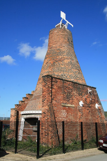
The Cementation furnace in Sheffield, South Yorkshire, England is a Grade II Listed Building and is the only example of this type of steel making furnace to survive intact in Great Britain. It is situated on Doncaster Street in the St Vincent's Quarter just 0.6 miles (1 km) north west of the city centre.
40. Jubilee Centre

The Wilson Road Synagogue is a former Orthodox Jewish congregation and synagogue, located at 11 Wilson Road, Ecclesall, Sheffield, England, in the United Kingdom. The congregation was formed in 1914 and worshiped in the Ashkenazi rite until the congregation was dissolved in 1997.
41. Medina Mosque

The Madina Mosque or Madina Masjid, also known as the "Wolseley Road Mosque", is the first purpose-built mosque in Sheffield, South Yorkshire, England. After some problems with funding, the project was completed in October 2006. Users of the mosque raised several million pounds to pay for the new mosque and Islamic centre which includes 19 rooms and two large halls, a library and a day centre. The project is estimated to have cost £5 million. The mosque was built on Glover Road, Sheffield, and intended to serve the Muslim populations of Nether Edge and Sharrow. The mosque has a capacity of 2,300.
Share
How likely are you to recommend us?
Disclaimer Please be aware of your surroundings and do not enter private property. We are not liable for any damages that occur during the tours.