30 Sights in Salford, United Kingdom (with Map and Images)

Here you can book tickets, guided tours and other activities in Salford:

Tickets and guided tours on GetYourGuide*

Explore interesting sights in Salford, United Kingdom. Click on a marker on the map to view details about it. Underneath is an overview of the sights with images. A total of 30 sights are available in Salford, United Kingdom.

List of cities in United Kingdom Sightseeing Tours in Salford

1. Imperial War Museum North

Show sight on map

Imperial War Museum North is a museum in the Metropolitan Borough of Trafford in Greater Manchester, England. One of five branches of the Imperial War Museum, it explores the impact of modern conflicts on people and society. It is the first branch of the Imperial War Museum to be located in the north of England. The museum occupies a site overlooking the Manchester Ship Canal on Trafford Wharf Road, Trafford Park, an area which during the Second World War was a key industrial centre and consequently heavily bombed during the Manchester Blitz in 1940. Just across the Trafford Wharf Road from the Museum is the bulk of the Rank Hovis Flour Mill, a survivor from a former industrial age and now rather out of keeping with the surrounding architecture. The area is now home to the Lowry cultural centre and the MediaCityUK development, which stand opposite the museum at Salford Quays.

Wikipedia: Imperial War Museum North (EN), Website

2. Ordsall Hall

Show sight on map

Ordsall Hall is a large former manor house in the historic parish of Ordsall, Lancashire, England, now part of the City of Salford, in Greater Manchester. It dates back more than 750 years, although the oldest surviving parts of the present hall were built in the 15th century. The most important period of Ordsall Hall's life was as the family seat of the Radclyffe family, who lived in the house for more than 300 years. The hall was the setting for William Harrison Ainsworth's 1842 novel Guy Fawkes, written around the plausible although unsubstantiated local story that the Gunpowder Plot of 1605 was planned in the house.

Wikipedia: Ordsall Hall (EN)

3. Blue Peter Garden

Show sight on map
Blue Peter Garden BBC / Fair use

Blue Peter is a British children's television entertainment programme created by John Hunter Blair. It is the longest-running children's TV show in the world, having been broadcast since October 1958. It was broadcast primarily from BBC Television Centre in London until September 2011, when the programme moved to dock10 studios at MediaCityUK in Salford, Greater Manchester. It is currently shown live on the CBBC television channel on Fridays at 5pm. The show is also repeated on Saturdays at 11:30am, Sundays at 9:00am and a BSL version is shown on Tuesdays at 2:00pm.

Wikipedia: Blue Peter (EN)

4. Peel Park

Show sight on map

Peel Park is a public urban park in Salford, Greater Manchester, England, located on the flood plain of the River Irwell below Salford Crescent and adjacent to the University of Salford. It was the first of three public parks to be opened on 22 August 1846, for the people of Manchester and Salford, paid for by public subscription. The park was the main public venue for the 1851 royal visit of Queen Victoria to Manchester and Salford and has been the subject of a number of paintings by the Salford artist, L. S. Lowry.

Wikipedia: Peel Park, Salford (EN), Website

5. Town Hall

Show sight on map

Salford Town Hall is the former town hall of Salford, Greater Manchester, England. It was the meeting place of the County Borough of Salford. Following the abolition of the county borough, it became Salford Magistrates' Court and continued to be used as such until 2011. The court was then merged with the court of Manchester to form the Manchester and Salford Magistrates' Court. The building is now in residential use and is a Grade II Listed Building being designated in January 1952.

Wikipedia: Salford Town Hall (EN), Website

6. Angel Meadow

Show sight on map

St Michael's Flags and Angel Meadow Park is a public park in Manchester, England, to the immediate northeast of the city centre, on a slope between the River Irk and Rochdale Road. It occupies an area of 7.4 acres (3 ha), and was once an affluent suburb, until the 19th-century Industrial Revolution altered the social standing of the area and introduced poverty and disease. Regeneration of the park in the 2000s has created a gateway into the Irk Valley.

Wikipedia: St Michael's Flags and Angel Meadow Park (EN)

7. St. Augustine's Church

Show sight on map

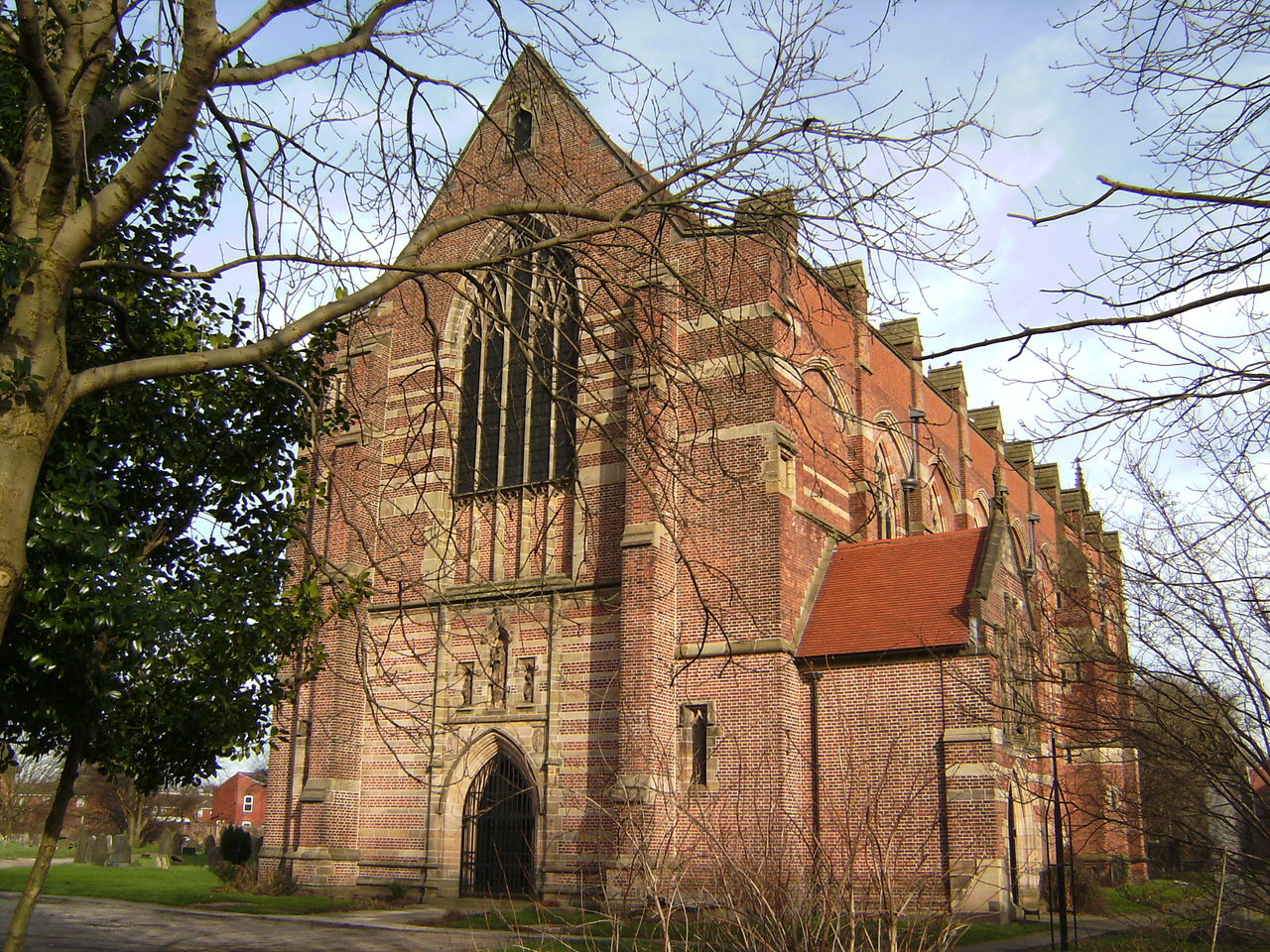
St. Augustine's Church is an active Anglican church in Pendlebury, Greater Manchester, England. Dedicated to St Augustine, it is part of the benefice of Swinton and Pendlebury along with St Peter's Church in Swinton and All Saints' Church in Wardley. The church is in the Eccles deanery, the archdeaconry of Salford and the diocese of Manchester. The church was granted Grade II* listed status in 1966 but has since been upgraded to Grade I.

Wikipedia: St Augustine's Church, Pendlebury (EN)

8. The Tree of Knowledge

Show sight on map

The Tree of Knowledge is a relief mural by the artist Alan Boyson. It was created in 1962 for Cromwell Secondary School for Girls in Salford, England, and erected on an end wall on the exterior of the school building. It is made from concrete, with ceramic tiles and pebbles collected from the site for which it was designed It measures approximately 7 metres (23 ft) square. It depicts five stylised birds, one an owl, sitting in a tree.

Wikipedia: The Tree of Knowledge (mural) (EN)

9. Manchester Opera House

Show sight on map

The Opera House in Quay Street, Manchester, England, is a 1,920-seater commercial touring theatre that plays host to touring musicals, ballet, concerts and a Christmas pantomime. It is a Grade II listed building. The Opera House is one of the main theatres in Manchester, England. The Opera House and its sister theatre the Palace Theatre, Manchester on Oxford Street are operated by the same parent company, Ambassador Theatre Group.

Wikipedia: Manchester Opera House (EN), Website

10. River Irwell Railway Bridge

Show sight on map

The River Irwell Railway Bridge was built for the Liverpool & Manchester Railway (L&MR), the world's first passenger railway which used only steam locomotives and operated as a scheduled service, near Water Street in Manchester, England. The stone railway bridge, built in 1830 by George Stephenson, was part of Liverpool Road railway station. The bridge was designated a Grade I listed building on 20 June 1988.

Wikipedia: River Irwell Railway Bridge (EN)

11. Corn Exchange

Show sight on map

Corn Exchange, Manchester is a grade II listed building in Manchester, England. The building was originally used as a corn exchange and was previously named the Corn & Produce Exchange, and subsequently The Triangle. Following the IRA bomb in 1996 it was renovated and was a modern shopping centre until 2014. The building was sold to investors and has been re-developed into a number of food outlets.

Wikipedia: Corn Exchange, Manchester (EN), Website

12. Palace Theatre

Show sight on map

The Palace Theatre, Manchester, is one of the main theatres in Manchester, England. It is situated on Oxford Street, on the north-east corner of the intersection with Whitworth Street. The Palace and its sister theatre the Opera House on Quay Street are operated by the same parent company, Ambassador Theatre Group. The original capacity of 3,675 has been reduced to its current 1,955.

Wikipedia: Palace Theatre, Manchester (EN), Website

13. AO Arena

Show sight on map

Manchester Arena, currently referred to as the AO Arena for sponsorship reasons, is an indoor arena in Manchester, England, immediately north of the city centre and partly above Manchester Victoria station in air rights space. The arena has the highest seating capacity of any indoor venue in the United Kingdom, and the second largest in Europe with a capacity of 21,000.

Wikipedia: Manchester Arena (EN), Website

14. Science and Industry Museum

Show sight on map

The Science and Industry Museum in Manchester, England, traces the development of science, technology and industry with emphasis on the city's achievements in these fields. The museum is part of the Science Museum Group, a non-departmental public body of the Department for Digital, Culture, Media and Sport, having merged with the National Science Museum in 2012.

Wikipedia: Science and Industry Museum (EN), Website

15. St Mark (Church of England)

Show sight on map

St Mark's Church is an active Anglican parish church in Worsley, Greater Manchester, England. It is part of a team ministry along with St Mary's in Ellenbrook and St Andrew in Boothstown. The church is in the Eccles deanery, the archdeaconry of Salford and the diocese of Manchester. The church was granted Grade I Listed status in 1966.

Wikipedia: St Mark's Church, Worsley (EN)

16. Manchester Cathedral

Show sight on map

Manchester Cathedral, formally the Cathedral and Collegiate Church of St Mary, St Denys and St George, in Manchester, England, is the mother church of the Anglican Diocese of Manchester, seat of the Bishop of Manchester and the city's parish church. It is on Victoria Street in Manchester city centre and is a grade I listed building.

Wikipedia: Manchester Cathedral (EN), Website

17. The Lowry

Show sight on map

The Lowry is a theatre and gallery complex at Salford Quays, Salford, Greater Manchester, England. It is named after the early 20th-century painter L. S. Lowry, known for his paintings of industrial scenes in North West England. The complex opened on 28 April 2000 and was officially opened on 12 October 2000 by Queen Elizabeth II.

Wikipedia: The Lowry (EN), Website

18. Salford Lads Club

Show sight on map

Salford Lads' Club is a recreational club in the Ordsall area of Salford, Greater Manchester, England. The club, on the corner of St. Ignatius Walk and Coronation Street, was established in 1903 as a boys' club but today welcomes people of both sexes and organises activities including sports and exhibitions.

Wikipedia: Salford Lads' Club (EN), Website

19. Canada House

Show sight on map
Canada House Stephen Richards / CC BY-SA 2.0

Canada House is an Art Nouveau-style office building on Chepstow Street in Manchester, England. Constructed originally as a packing warehouse, the building opened in 1909. Designed by local architects W & G Higginbottom, the building has features consistent with art nouveau and has a terracotta exterior.

Wikipedia: Canada House, Manchester (EN)

20. Emmeline Pankhurst

Show sight on map

The statue of Emmeline Pankhurst is a bronze sculpture in St Peter's Square, Manchester, depicting Emmeline Pankhurst, a British political activist and leader of the suffragette movement in the United Kingdom. Hazel Reeves sculpted the figure and designed the Meeting Circle that surrounds it.

Wikipedia: Statue of Emmeline Pankhurst (EN)

21. Manchester Oratory

Show sight on map

The Oratory Church of Saint Chad's, Manchester is a Grade II listed Catholic church in Cheetham Hill, Manchester, England. It was constructed between 1846 and 1847, on the east side of Cheetham Hill Road. The parish functions under the jurisdiction of the Roman Catholic Diocese of Salford.

Wikipedia: Manchester Oratory (EN)

22. Cathedral of St John the Evangelist

Show sight on map

The Cathedral Church of St. John the Evangelist, usually known as Salford Cathedral, is a Catholic cathedral on Chapel Street in Salford, Greater Manchester, England. It is the seat of the Bishop of Salford and mother church of the Diocese of Salford, and is a Grade II* listed building.

Wikipedia: Salford Cathedral (EN)

23. Abraham Lincoln

Show sight on map

Albert Square is a public square in the centre of Manchester, England. It is dominated by its largest building, the Grade I listed Manchester Town Hall, a Victorian Gothic building by Alfred Waterhouse. Other smaller buildings from the same period surround it, many of which are listed.

Wikipedia: Albert Square, Manchester (EN)

24. St Philip's Church

Show sight on map
St Philip's Church Richerman (talk) 11:41, 28 February 2008 (UTC) / CC BY-SA 3.0

St Philip's Church is an Anglican parish church in the diocese of Manchester, in the deanery and archdeaconry of Salford. The church was relaunched in 2016 as Saint Philip's Chapel Street. It is located at Wilton Place, just off Chapel Street in Salford, Greater Manchester, England.

Wikipedia: St Philip's Church, Salford (EN)

25. Salford Museum and Art Gallery

Show sight on map
Salford Museum and Art Gallery Richerman (talk) 23:26, 4 February 2008 (UTC) / CC BY-SA 3.0

Salford Museum and Art Gallery, in Peel Park, Salford, Greater Manchester, opened to the public in November 1850 as the Royal Museum and Public Library. The gallery and museum are devoted to the history of Salford and Victorian art and architecture.

Wikipedia: Salford Museum and Art Gallery (EN), Website

26. St Mary's - The Hidden Gem

Show sight on map
St Mary's - The Hidden Gem Tim Green from Bradford / CC BY 2.0

The Hidden Gem, officially St Mary's Catholic Church, is a church on Mulberry Street, Manchester, England. The parish dates back to 1794, with devotion to St Mary, Our Lady of the Assumption, however the church was rebuilt in 1848.

Wikipedia: The Hidden Gem (EN)

27. St. Ann's Church

Show sight on map

St Ann's Church is a Church of England parish church in Manchester, England. Although named after St Anne, it also pays tribute to the patron of the church, Ann, Lady Bland. St Ann's Church is a Grade I listed building.

Wikipedia: St Ann's Church, Manchester (EN), Website

28. Sackville Gardens

Show sight on map

Sackville Gardens is a public space in Manchester, England. It is bounded by Manchester College's Shena Simon Campus on one side and Whitworth Street, Sackville Street, the Rochdale Canal and Canal Street on the others.

Wikipedia: Sackville Gardens (EN)

29. National Football Museum

Show sight on map
National Football Museum David Dixon / CC BY-SA 2.0

The National Football Museum is England's national museum of football. It is based in the Urbis building in Manchester city centre, and preserves, conserves and displays important collections of football memorabilia.

Wikipedia: National Football Museum (EN), Website

30. The Old Wellington Inn

Show sight on map

The Old Wellington Inn is a half-timbered pub in Manchester city centre, England. It is part of Shambles Square, which was created in 1999, and is near Manchester Cathedral. It is a Grade II listed building.

Wikipedia: The Old Wellington Inn (EN), Website

Share

Spread the word! Share this page with your friends and family.

Disclaimer Please be aware of your surroundings and do not enter private property. We are not liable for any damages that occur during the tours.