38 Sights in North Yorkshire, United Kingdom (with Map and Images)
Legend
Welcome to your journey through the most beautiful sights in North Yorkshire, United Kingdom! Whether you want to discover the city's historical treasures or experience its modern highlights, you'll find everything your heart desires here. Be inspired by our selection and plan your unforgettable adventure in North Yorkshire. Dive into the diversity of this fascinating city and discover everything it has to offer.
1. Star Carr

Star Carr is a Mesolithic archaeological site in North Yorkshire, England. It is around five miles (8 km) south of Scarborough. It is generally regarded as the most important and informative Mesolithic site in Great Britain. It is as important to the Mesolithic period as Stonehenge is to the Neolithic period or Scandinavian York is to understanding Viking Age Britain.
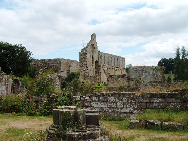
2. Studley Royal Water Garden

Studley Royal Park is an estate in North Yorkshire, England. The site has an area of 800 acres (323 ha) and includes an 18th-century landscaped garden; the ruins of Fountains Abbey; Fountains Hall, a Jacobean mansion; and the Victorian St Mary's church, designed by William Burges. Studley Royal House, around which the park and gardens were designed, burned down in 1946. The park, as Studley Royal Park including the ruins of Fountains Abbey, has been designated a World Heritage Site. It has also been designated a grade I listed park and garden by Historic England, and various structures within it are individually listed.
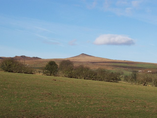
3. Pen-y-ghent

Pen-y-ghent or Penyghent is a fell in the Yorkshire Dales, England. It is the lowest of Yorkshire's Three Peaks at 2,277 feet (694 m); the other two being Ingleborough and Whernside. It lies 1.9 miles (3 km) east of Horton in Ribblesdale. It has a number of interesting geological features, such as Hunt Pot, and further down, Hull Pot. The waters that flow in have created an extensive cave system which rises at Brants Gill head.
4. Gaping Gill

Gaping Gill is a natural cave in North Yorkshire, England. It is one of the unmistakable landmarks on the southern slopes of Ingleborough – a 98-metre (322 ft) deep pothole with the stream Fell Beck flowing into it. After falling through one of the largest known underground chambers in Britain, the water disappears into the bouldery floor and eventually resurges adjacent to Ingleborough Cave.
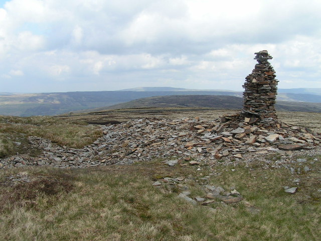
5. Tan Hill

Tan Hill is a high point on the Pennine Way in the Richmondshire district of North Yorkshire, England. It lies north of Keld in the civil parish of Muker, near the borders of County Durham and Westmorland, and close to the northern boundary of the Yorkshire Dales National Park. It fell within the historic boundaries of the North Riding of Yorkshire. It is in an isolated location, the nearest town of Kirkby Stephen being an 11-mile (18 km) drive away.
6. Jervaulx Abbey
Jervaulx Abbey in East Witton in North Yorkshire, 14 mi (23 km) north-west of the city of Ripon, was one of the great Cistercian abbeys of Yorkshire, England, dedicated to St Mary in 1156. It is a Grade I listed building.
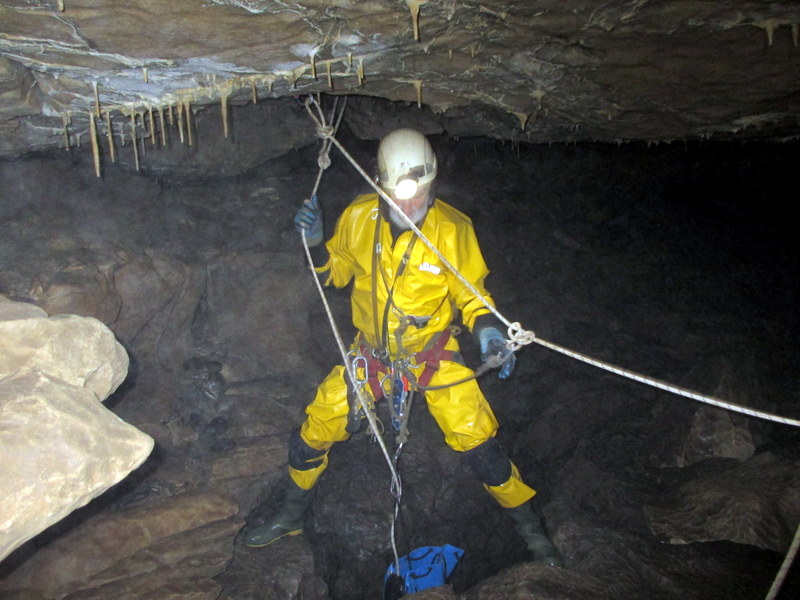
7. Mossdale Caverns

Mossdale Caverns is a cave system in the Yorkshire Dales, England. It is about 5 kilometres (3.1 mi) north of Grassington, and east of Conistone, where Mossdale Beck sinks at the base of Mossdale Scar. It lies at an altitude of 425 metres (1,394 ft) on the eastern flank of Wharfedale, and extends south-east beneath Grassington Moor.
8. Hardraw Force

Hardraw Force is a waterfall on Hardraw Beck in Hardraw Scar, a wooded ravine just outside the hamlet of Hardraw, 0.9 miles (1.5 km) north of the town of Hawes, Wensleydale, in the Yorkshire Dales. The Pennine Way long distance footpath passes close by.
9. Church of Christ the Consoler

The Church of Christ the Consoler is a Victorian Gothic Revival church built in the Early English style by William Burges. It is located in the grounds of Newby Hall at Skelton-on-Ure, in North Yorkshire, England. Burges was commissioned by George Robinson, 1st Marquess of Ripon, to build it as a tribute to the Marquess' brother-in-law, Frederick Vyner. The church is a Grade I listed building as of 6 March 1967, and was vested in the Churches Conservation Trust on 14 December 1991.
10. Great Whernside

Great Whernside is a fell in the Yorkshire Dales, England, not to be confused with Whernside, some 17 miles (27 km) to the west. Its summit is the highest point of the eastern flank of Wharfedale above Kettlewell. Great Whernside forms the watershed between Wharfedale and Nidderdale, and is on the boundary between the Yorkshire Dales National Park and Nidderdale Area of Outstanding Natural Beauty. The River Nidd rises on the eastern slopes of Great Whernside, above Angram Reservoir.
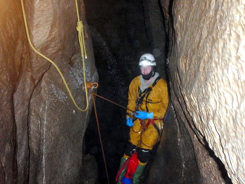
11. Rowten Pot

Rowten Pot is one of several entrances into the 27-kilometre (17 mi) long cave system that drains Kingsdale in North Yorkshire, England. Its entrance is a shaft some 27 metres (89 ft) long, 10 metres (33 ft) wide, and at the southern end 72 metres (236 ft) deep.
12. Calver Hill

Calver Hill is a fell in the Yorkshire Dales National Park in North Yorkshire, England. It is composed of limestone and is situated at grid reference NZ012003, near where the valleys of Swaledale and Arkengarthdale meet, the village of Reeth is located on its lower south-eastern slopes, it reaches an altitude of 487 metres (1,598 ft) and is a distinguished feature in mid Swaledale. Calver Hill is an area of grouse shooting and the fell is dotted with grouse butts. Most of the drainage from the fell goes north and easterly to join the Arkle Beck in lower Arkengarthdale which eventually joins the River Swale just south of Reeth.
13. Langcliffe Pot

Langcliffe Pot is a cave system on the slopes of Great Whernside in Upper Wharfedale, about 3 kilometres (1.9 mi) SSE of Kettlewell in North Yorkshire. It is part of the Black Keld Site of Special Scientific Interest where the "underground drainage system which feeds the stream resurgence at Black Keld is one of the largest and deepest in Britain, although only a small proportion of its cave passages are accessible at present." Mossdale Caverns is also part of the Black Keld SSSI. Although a considerable length of passage has been explored in Langcliffe Pot, the current end is over 170 metres (560 ft) above the resurgence, and over 4 kilometres (2.5 mi) in distance. A trip to the far end has been described as "one of the most serious undertakings in British caving".
14. Aquamole Pot
Aquamole Pot is a limestone cave in West Kingsdale, North Yorkshire, England. It was originally discovered by cave divers who negotiated 168 metres (551 ft) of sump passage from Rowten Pot in 1974, to enter a high aven above the river passage. All subsequent major explorations were undertaken from below before an entrance was opened up from the surface. It is part of a 27-kilometre (17 mi) long cave system that drains both flanks of Kingsdale.
15. Fountains Fell South Top
Fountains Fell is a mountain in the Yorkshire Dales, England. The main summit has a height of 668 metres (2,192 ft) and a relative height or topographic prominence of 243 metres (797 ft) and thus qualifies as a Marilyn. Its subsidiary, Fountains Fell South Top reaches 662 metres (2,172 ft) and qualifies as a Nuttall. A third summit, further south at SD868697, reaches 610 metres (2,001 ft) and is the most southerly 2,000 ft summit in the Pennines.
16. Great Shunner Fell

Great Shunner Fell is the third-highest mountain in the Yorkshire Dales, North Yorkshire, England, and the highest point in Wensleydale; at 716 metres above sea level. In clear weather the summit affords views of Wensleydale to the south, Ribblesdale to the southwest and Swaledale to the north, as well as views into Cumbria and County Durham beyond the A66.
17. Simpson Pot

Named after Eli Simpson, Simpson Pot is a limestone cave in West Kingsdale, North Yorkshire, England. It leads into Swinsto Cave and thence into Kingsdale Master Cave, and it is popular with cavers as it is possible to descend it by abseiling down the pitches, retrieving the rope each time, and exiting through Valley Entrance of Kingsdale Master Cave at the base of the hill. It is part of a 27-kilometre (17 mi) long cave system that drains both flanks of Kingsdale.
18. Catrake Force

Catrake Force is a waterfall on the River Swale in North Yorkshire, England. It is not visible from the road but is accessible via a campsite in Keld. It comprises a series of four steps, each its own small waterfall, and each with a very different character – the largest single drop being about 20 feet (6.1 m).
19. Eden Sike Cave

Eden Sike Cave is a small cave in Mallerstang in the Eden valley in Cumbria, England 400 metres (440 yd) north of Hell Gill. The entrance is 391 metres (428 yd) north west of an obvious resurgence in a small shakehole. This drops into a passage where a wet crawl leads downstream towards the resurgence, and a roomier passage going upstream. The upstream passage soon deteriorates into more awkward going which eventually passes a small but awkward climb into an inlet passage up to the right. The main passage goes to a sump some 9 metres (30 ft) long which has been passed to a further 15 metres (49 ft) before becoming too tight. The right-hand passage passes a section of sharp, steeply angled rock into a chamber where the way on is a tight, wet passage where the airspace becomes minimal.
20. Kisdon Force

Kisdon Force is a series of waterfalls on the River Swale in Swaledale, England. The falls are situated within the Yorkshire Dales National Park in the county of North Yorkshire, 500 metres downstream from the small hamlet of Keld at grid reference NY898010.
21. East Gill Force (upper)

East Gill Force is a waterfall in Swaledale, 330 yards (300 m) east of the hamlet of Keld, in the Yorkshire Dales National Park, North Yorkshire, England. The falls are located on East Gill at grid reference NY896012, just before its confluence with the River Swale at the point where the Pennine Way and the Coast to Coast Walk intersect. The falls are a popular spot for visitors, not just long-distance walkers but also families and picnickers because of the proximity of the road. East Gill Force has two main torrents: the upper falls have an impressive 15-foot (4.5 m) drop whilst the lower section is a series of stepped cascades that fall 9.8 feet (3 m) as East Gill enters the River Swale.
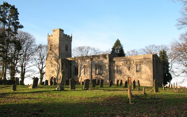
22. St Mary

St Mary's Church is a redundant Church of England parish church in the village of Roecliffe, North Yorkshire, England. It is a Grade II* listed building and is in the care of the Churches Conservation Trust.
23. Sharp Haw
Sharp Haw is a hill on the southern edge of the Yorkshire Dales, located just within the National Park. Being the last outpost of the hills before the broad Aire valley, and with a sharp summit from many angles, it is prominent and easily recognisable from much of the area to the south. The hill has an elevation of 357 metres (1,171 ft).
24. St Mary's Church
St Mary's Church is a redundant Anglican church standing in open countryside in the former village of South Cowton, near Scotch Corner in North Yorkshire, England. It is recorded in the National Heritage List for England as a designated Grade I listed building, and is under the care of the Churches Conservation Trust.
25. Cawthorn Roman Camp D

Cawthorn Camp is a Roman site in northeast England, about 4 miles (6 km) north of Pickering, North Yorkshire. The well-preserved earthworks outline two forts, one with an extension and a temporary camp built to an unusual plan. The earthworks date from the late 1st or early 2nd century AD. It has been suggested that they were built for practice rather than military use.
26. Swinsto Hole
Swinsto Cave is a limestone cave in West Kingsdale, North Yorkshire, England. It leads into Kingsdale Master Cave and it is popular with cavers as it is possible to descend by abseiling down the pitches, retrieving the rope each time, and exiting through Valley Entrance of Kingsdale Master Cave at the base of the hill. It is part of a 27-kilometre (17 mi) long cave system that drains both flanks of Kingsdale.
27. Bar Pot

Bar Pot is one of the entrances to the Gaping Gill cave system being located about 340 metres (370 yd) south of Gaping Gill Main Shaft, on Ingleborough in the Yorkshire Dales. It is a popular entrance into the system, being one of the easiest, driest, and having just two vertical pitches to contend with. It lies within the designated Ingleborough Site of Special Scientific Interest.
28. Lovely Seat

Lovely Seat, originally known as Lunasett until being misnamed by map makers some time in the twentieth century, is a fell in the Yorkshire Dales National Park in North Yorkshire, England. It reaches a height of 675 metres (2,215 feet). It is situated at grid reference SD878950 three miles north of the town of Hawes, and is part of the high ground which separates Wensleydale from Swaledale. It is the highest point of Abbotside Common. The fell is separated from its neighbour to the west, Great Shunner Fell, by the Buttertubs Pass which carries the minor motor road between Hawes in Wensleydale and Thwaite in Swaledale. The name Lunasett derives from the Norse dialect moon pasture; Commoners of Abbotside still use the original name.
29. St Michael's Church

St Michael's Church is a redundant church in the village of Cowthorpe, North Yorkshire, England. It is recorded in the National Heritage List for England as a designated Grade I listed building, and is under the care of the Churches Conservation Trust.
30. Meugher

Meugher is a hill in the Yorkshire Dales, England. It lies in remote country between Wharfedale and Nidderdale, in the parish of Stonebeck Down less than 1 kilometre (0.6 mi) outside the Yorkshire Dales National Park but within the Nidderdale Area of Outstanding Beauty. The hill has a conical peak topped by an Ordnance Survey triangulation pillar, and has been described as "perhaps the remotest and least inviting summit in the Yorkshire Dales". No public rights of way approach the summit, but since the Countryside and Rights of Way Act 2000 it has been on open access land. It can be accessed by a shooting track from near Lofthouse, which now approaches within 430 metres of the summit, or from a public footpath a mile north west of the summit, leading from Middlesmoor to Conistone.
31. Plover Hill

Plover Hill is an area of moorland lying to the north of Pen-y-ghent in the Yorkshire Dales and connected to it by an unbroken area of high ground. Whilst the whole area is now "open access land", the main right-of-way footpaths come directly from the north off Foxup Road and directly from the south from the summit of Pen-y-ghent.
32. Atlas Fountain

The Atlas Fountain stands in the grounds of Castle Howard, North Yorkshire, England. It has been designated a Grade I listed building and is now recorded in the National Heritage List for England, maintained by Historic England.
33. Flood Entrance Pot

Flood Entrance Pot is one of the entrances to the Gaping Gill cave system located about 300 metres (330 yd) south of Gaping Gill Main Shaft. It was the first alternative entrance into the main system to be explored, and it is now a popular entrance into the system, with a fine 38-metre (125 ft) pitch landing in Gaping Gill's South-East Passage. It lies within the designated Ingleborough Site of Special Scientific Interest.
34. Disappointment Pot

Disappointment Pot is one of the entrances to the Gaping Gill cave system, located in a steep grassy shakehole some 120 metres (130 yd) south-east of Gaping Gill Main Shaft. Its mainly narrow stream passage descends a number of small shafts to enter the main system as a major inlet of Hensler's Master Cave. It lies within the designated Ingleborough Site of Special Scientific Interest.
35. White Hill

Hasty Bank is a hill in the Cleveland Hills range of the North York Moors, in north-east England. The Cleveland Way National Trail crosses Hasty Bank and is part of Wainwright's Coast to Coast Walk. The north face of Hasty Bank has heavily eroded, possessing a vertical rocky face sloping steeply down to Broughton Bank. Roseberry Topping can be clearly seen from the summit which offers great views of the Tees Valley.
36. Hoove

Hoove is a hill in the northern Yorkshire Dales in North Yorkshire, England, near the town of Barnard Castle in County Durham. Its elevation is 554 metres (1,818 ft), and it is classified as a Marilyn.
37. Little Whernside

Little Whernside is a hill in the Yorkshire Dales, North Yorkshire, England, 2.82 miles (4.54 km) north east of Great Whernside. It is on the boundary between the Yorkshire Dales National Park and Nidderdale Area of Outstanding Natural Beauty, and forms part of the watershed between Coverdale and Nidderdale. The highest point is marked by a cairn, a few metres inside the National Park.
38. Simon's Seat

Simon's Seat is a peak in the Yorkshire Dales in northern England. It is a prominent outcrop of millstone grit on the eastern side of Wharfedale. Although only 485 metres (1,591 ft) high, the extensive views from the summit make it a popular destination for walkers.
Share
How likely are you to recommend us?
Disclaimer Please be aware of your surroundings and do not enter private property. We are not liable for any damages that occur during the tours.