9 Sights in Great Yarmouth, United Kingdom (with Map and Images)
Legend
Welcome to your journey through the most beautiful sights in Great Yarmouth, United Kingdom! Whether you want to discover the city's historical treasures or experience its modern highlights, you'll find everything your heart desires here. Be inspired by our selection and plan your unforgettable adventure in Great Yarmouth. Dive into the diversity of this fascinating city and discover everything it has to offer.
Sightseeing Tours in Great Yarmouth1. Old Lighthouse

Winterton Lighthouse is located in Winterton-on-Sea in the English county of Norfolk. In 1845 Winterton Ness was described as being 'well known to the mariner as the most fatal headland between Scotland and London'. As well as marking the headland, the lighthouse was intended to help guide vessels into the Cockle Gat, which provided the northern entry into the safe water of Yarmouth Roads. The lighthouse was known to Daniel Defoe and is mentioned in his novel Robinson Crusoe.
2. Burgh Castle Roman Site

Burgh Castle is the site of one of nine Roman Saxon Shore forts constructed in England around the 3rd century AD, to hold troops as a defence against Saxon raids up the rivers of the east and south coasts of southern Britain. It is located on the summit of ground sloping steeply towards the estuary of the River Waveney, in the civil parish of Burgh Castle, in the county of Norfolk.
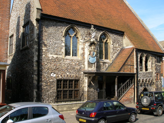
3. Time & Tide Museum

Time and Tide: The Museum of Great Yarmouth Life, located in Great Yarmouth, Norfolk, UK, is a maritime and fishing museum in Great Yarmouth and established in 2005. It is situated in a former Victorian herring curing factory known as Tower Curing Works, and is now part of Maritime Heritage East, a partnership of over 30 maritime museums in the East of England.
4. Caister Roman Fort

Caister Roman Site is a Roman Saxon Shore fort, located in Caister-on-Sea, Norfolk, England. It was constructed around AD 200 for use by units of the Roman army and navy, and was occupied until around 370-390 AD. This fort was possibly known as Gariannonum, although the single record that describes it as such may also mean the Roman site at Burgh Castle.
5. Gorleston South Pier Lighthouse

Gorleston South Pier Lighthouse and Coastwatch watch station is located in the town of Gorleston in the English county of Norfolk. The lighthouse and station is located at the end of the south pier of seaport on the south side of Great Yarmouth.
6. Gorleston (Range Rear) Lighthouse

Gorleston Lighthouse is located near mouth of River Yare in the Gorleston-on-Sea area of Great Yarmouth in the English county of Norfolk. The lighthouse was built in 1878. Gorleston-on-Sea lighthouse carries two lights. The rear light for the harbour entrance range is mounted on the tower with a focal plane of 6.7 metres (22 ft); a fixed red light is also displayed from the gallery with a focal plane of 20.1 metres (66 ft).
7. Saint Marys Catholic Church

St Mary's Church is a Roman Catholic Parish church in Great Yarmouth, Norfolk. It is situated on Regent Road in the centre of the town. It was originally built by the Society of Jesus in the late 1840s and it is now administered by the Diocese of East Anglia. The architect was Joseph John Scoles who also designed the Anglican St Mary's church in the Southtown area of Great Yarmouth and it is a Grade II* listed building.
8. The Tolhouse Gaol
The Tolhouse is a 12th-century building in Great Yarmouth, Norfolk, England. The building has been used as a jail and a courthouse and is currently a museum. The Tolhouse is a Grade I listed building.
9. Row 111 House

Great Yarmouth Row Houses were wealthy merchants' residences located on South Quay in the town of Great Yarmouth in the English county of Norfolk. Originally built as one family's dwelling, the properties were later sub-divided into tenements and became part of the town's distinctive "Rows"', a network of narrow alleyways linking Yarmouth's three main thoroughfares. Many "Row Houses" were damaged by Second World War bombing or demolished during post-war clearances. These two surviving properties have been preserved to show the different characteristics of the dwellings over various stages in their history. The Row Houses are under the management and care of English Heritage.
Share
How likely are you to recommend us?
Disclaimer Please be aware of your surroundings and do not enter private property. We are not liable for any damages that occur during the tours.