8 Sights in Folkestone and Hythe District, United Kingdom (with Map and Images)
Legend
Welcome to your journey through the most beautiful sights in Folkestone and Hythe District, United Kingdom! Whether you want to discover the city's historical treasures or experience its modern highlights, you'll find everything your heart desires here. Be inspired by our selection and plan your unforgettable adventure in Folkestone and Hythe District. Dive into the diversity of this fascinating city and discover everything it has to offer.
1. Saltwood Castle

Saltwood Castle is a castle in Saltwood village, one mile (2 km) north of Hythe, Kent, England. Of 11th century origin, the castle was expanded in the 13th and 14th centuries. After the Norman Conquest, the castle was appropriated by the Archbishop of Canterbury Lanfranc and remained the property of the archbishops, with some interruptions, until 1540, when Thomas Cranmer was compelled to cede it to Henry VIII. The castle is reputed to have been the meeting place of the four knights who carried out the assassination of Thomas Becket in 1170. By the 19th century, it was "largely ruinous" and restorations to make portions of the castle habitable were carried out in the 1880s and 1930s. In the late 19th century, the castle was bought by an ancestor of Bill Deedes, the journalist and politician, who grew up there. In the 20th century, it was sold to Sir Martin Conway who commissioned Philip Tilden to undertake a restoration. In 1953, the castle was bought by the art historian Kenneth Clark (1903–1983), and then became the home of his son, the politician and diarist, Alan Clark (1928–1999). It remains the private home of his widow, Jane Clark. The castle is a Grade I listed building.
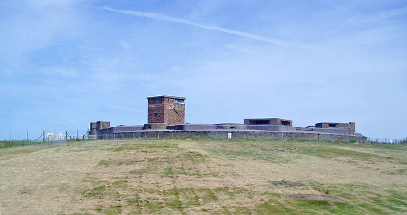
2. Sandgate Castle

Sandgate Castle is an artillery fort originally constructed by Henry VIII in Sandgate in Kent, between 1539 and 1540. It formed part of the King's Device programme to protect England against invasion from France and the Holy Roman Empire, and defended a vulnerable point along the coast. It comprised a central stone keep, with three towers and a gatehouse. It could hold four tiers of artillery, and was fitted with a total of 142 firing points for cannon and handguns.
3. Church of All Saints

All Saints' Church, also known as Lydd Church or The Cathedral on the Marsh, is a church in Lydd, Kent, South East England. It belongs to the Diocese of Canterbury. All Saints is the longest parish church in Kent at 199 feet (61 m), and also has one of the tallest towers in the county at 132 feet (40 m). The church is thought to incorporate a small Romano-British basilica possibly built in the 5th century, though most of the current fabric is medieval. It was associated with local fraternities or guilds in the 15th century and could seat 1,000 people at a time. Severely damaged by World War II bombing, the church was subsequently restored and is now a Grade I listed building.
4. Dymchurch Redoubt
Dymchurch Grand Redoubt is a fortification at Palmarsh on the coast of Kent in England, built during the Napoleonic War as part of a large defensive scheme to protect the country from an expected French invasion.
5. Dungeness Lighthouse

Dungeness Lighthouse on the Dungeness Headland started operation on 20 November 1961. Its construction was prompted by the building of Dungeness nuclear power station, which obscured the light of its predecessor which, though decommissioned, remains standing. The new lighthouse is constructed of precast concrete rings; its pattern of black and white bands is impregnated into the concrete. It remains in use today, monitored and controlled from the Trinity House Operations and Planning Centre at Harwich, Essex.
6. Portus Lemanis

Portus Lemanis, also known as Lemanae, was the Latin name of a Roman Saxon Shore fort, settlement and port in southern Kent. The modern village of Lympne derives its name from the ancient port. The site, known locally as Stutfall Castle, is on private land which is accessible by public footpath.
7. Folkestone Roman Villa

Folkestone Roman Villa, also referred to as the East Bay Site, is a villa built during the Roman Occupation of Britain, and is located in East Wear Bay near the port town of Folkestone, in Kent, England. The villa is situated on a cliff top overlooking the English Channel, with views of the French coast at Boulogne on a clear day. It is situated near the start of the North Downs Trackway, and the area has been inhabited for thousands of years, with archeological finds in the area and at the villa site dating back to the Mesolithic and Neolithic ages. The villa was built around A. D. 75, and was almost certainly built within the confines of a preexisting Iron Age settlement.
8. St Eanswith's Church

St Eanswith's Church is a Grade II* listed Anglican church in the village of Brenzett, Kent, about 7 miles (11 km) north-east of Rye, East Sussex. A church was originally built on this site in the 7th century; the present building dates from the 12th century and has later modifications.
Share
How likely are you to recommend us?
Disclaimer Please be aware of your surroundings and do not enter private property. We are not liable for any damages that occur during the tours.