22 Sights in Dumfries and Galloway, United Kingdom (with Map and Images)
Legend
Welcome to your journey through the most beautiful sights in Dumfries and Galloway, United Kingdom! Whether you want to discover the city's historical treasures or experience its modern highlights, you'll find everything your heart desires here. Be inspired by our selection and plan your unforgettable adventure in Dumfries and Galloway. Dive into the diversity of this fascinating city and discover everything it has to offer.
1. Drumlanrig Castle

Drumlanrig Castle is situated on the Queensberry Estate in Dumfries and Galloway, Scotland. The category A listed castle is the Dumfriesshire home of the Duke of Buccleuch and Queensberry. As of September 2023, the castle itself is open to the public during very limited times of the year, with the surroundings, such as the stableyard and adventure playground being open nearly all year round. Walking, hiking, and cycling routes are open all year long, unless officially closed due to unforeseen circumstances, such as in 2021 due damage inflicted by Storm Arwen.
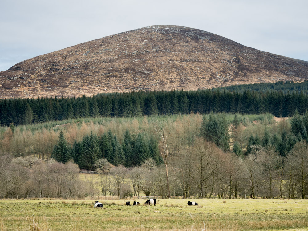
2. Merrick

The Merrick, or simply Merrick, is a mountain in the Range of the Awful Hand, a sub-range of the Galloway Hills range, part of the Southern Uplands of Scotland. The summit elevation is 843 metres, making it the highest mountain in the Southern Uplands and southern Scotland.
3. Logan Botanic Gardens

Logan Botanic Garden is a botanical garden near Port Logan on the Rhins of Galloway, at the south-western tip of Scotland. It is operated as part of the Royal Botanic Garden Edinburgh's Living Collection. It has been described as "Scotland's most exotic garden."
4. Cairnsmore of Fleet
Cairnsmore of Fleet is an isolated mountain in the Southern Uplands of Scotland. The mountain forms an unafforested granite massif, whose highest point is about ten kilometres east of Newton Stewart. It is the highest of the "Solway Hills" sub-range, and the southernmost of Scotland's 219 Grahams, thus making it, or rather its subsidiary top, Knee of Cairnsmore, the most southerly mountain in Scotland. The view to the south takes in the Cree Estuary and Wigtown Bay, and extends as far as the Lake District, the Isle of Man and Snowdonia. The highest summits of the Galloway Hills can be seen to the north, and Ireland is in the view to the west.
5. Garden of Cosmic Speculation

The Garden of Cosmic Speculation is a 30 acre sculpture garden created by landscape architect and theorist Charles Jencks and his wife, Maggie Keswick Jencks, on Maggie's land and their home together, Portrack House, in Dumfriesshire, Scotland. Like much of Jencks' work, the garden is inspired by modern cosmology.
6. Corsewall Lighthouse

Corsewall Lighthouse is a lighthouse at Corsewall Point, Kirkcolm near Stranraer in the region of Dumfries and Galloway in Scotland. First lit in 1817, it overlooks the North Channel of the Irish Sea.
7. Cairnsmore of Carsphairn

Cairnsmore of Carsphairn is a hill in the Carsphairn and Scaur Hills range, part of the Southern Uplands of Scotland. An alternative name, rarely used nowadays, is Cairnsmore of Deugh. It is the highest hill in the range, and its summit is just under six kilometres northeast of Carsphairn village as the crow flies, in the far north of Kirkcudbrightshire.
8. Kirriereoch Hill

Kirriereoch Hill is a hill in the Range of the Awful Hand, a sub-range of the Galloway Hills range, part of the Southern Uplands of Scotland. It lies on the border of the old counties of Ayrshire and Kirkcudbrightshire, or the modern regions of Dumfries and Galloway and South Ayrshire. A boundary wall near the summit is the highest point in South Ayrshire and Ayrshire as a whole. Kirriereoch Hill was classified as a Corbett and Marilyn but then deleted from these lists in 1984 due to not being thought to achieve the respective prominence criteria. In August 2015 the hill was relisted as a Marilyn after having been surveyed to have a 150.2 m prominence. However, since this is less than the 152.4 m required, the hill will not be re-listed as a Corbett.
9. White Coomb

White Coomb is a hill in the Moffat Hills range, part of the Southern Uplands of Scotland. Its broad summit is the highest point in the range and the registration county of Dumfriesshire, as well as being the fourth highest point in southern Scotland, however, despite this, it is largely concealed by other hills on all sides except its east and south east, making this the only direction from which its full scale can be seen.
10. Carsluith Castle
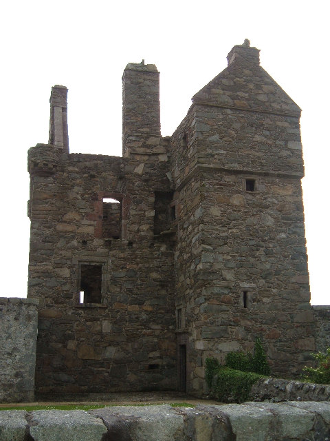
Carsluith Castle is a ruined tower house, dating largely to the 16th century. It is located beside Wigtown Bay in the historical county of Kirkcudbrightshire in Galloway, Scotland, around 4.8 kilometres (3.0 mi) south east of Creetown.
11. Burnswark Hill

Burnswark Hill, to the east of the A74(M) between Ecclefechan and Lockerbie in Dumfries and Galloway, Scotland, is a prominent flat-topped hill, composed of basalt deposited some 300 million years ago as a local flow of lava. On this hill have been found an Iron Age hillfort enclosing some 7 hectares, Iron Age round houses within the fort, an earlier Bronze Age burial cairn, enclosures dated to the medieval period, a possible Civil War battery, and an Ordnance Survey triangulation station. Immediately adjacent to the base of the hill are two Roman camps, north and south of the fort, and a possible Roman fortlet within the South Camp.
12. Corserine

Corserine is a hill in the Rhinns of Kells, a sub-range of the Galloway Hills range, part of the Southern Uplands of Scotland. The highest point of the range and the second highest point in Galloway, the usual route of ascent is from the car park at Forrest Lodge to the east of the hill via Loch Harrow and North Gairy Top. Forest Lodge is a short drive from the village of St. John's Town of Dalry.
13. Queensberry

Queensberry is a hill in the Lowther Hills range, part of the Southern Uplands of Scotland. The most southerly mountain in the range, it lies in the parish of Kirkpatrick-Juxta and is a prominent landmark throughout Dumfriesshire. It is frequently climbed from the Daer Reservoir to the north and the minor roads to its south and east. As well as being a placename of multiple addresses throughout southern Scotland, the hill also lend its name to the Duke of Queensberry and Marquess of Queensberry peerages and, subsequently, 'Queensberry Rules' in the sport of boxing.
14. Repentance Tower

The Repentance Tower is a very rare example of a mid-16th century watch tower standing on Trailtrow Hill, six miles north-west of Annan, Dumfries and Galloway. Built in 1565 by John Maxwell, the tower takes its name from an inscription Repentance carved on the stonework above the entrance door.
15. Craignaw

Craignaw is a hill in the Dungeon Hills, a sub-range of the Galloway Hills range, part of the Southern Uplands of Scotland. Unlike many hills in the Southern Uplands, Craignaw has a complex and rocky summit area, with a long line of crags and rough ground on the east side. The hill is largely composed of granite. Near the north end of the hill is an interesting area of terrain known as the "Deil's Bowlin' Green" where various rounded granite boulders are scatterd at random over an area of nearly horizontal granite slabs. These are believed to be glacial erratics or result from a similar glacier process. On the west side of the hill, near grid reference NX458831, a few hundred meters from the summit is an F-111E Aardvark crash site. The site is marked by a small memorial to the two U.S. Air Force pilots who were killed in the accident. Although the crash happened on 19 December 1979 there are still small amounts of aircraft debris in the area.
16. Lamachan Hill

Lamachan Hill is a hill in the Minnigaff Hills, a sub-range of the Galloway Hills range, part of the Southern Uplands of Scotland. It is the highest hill of the range, lying 11 kilometres (7 mi) north of Newton Stewart in Dumfries and Galloway.
17. Southerness lighthouse

Southerness lighthouse is located at the village of Southerness in South West Scotland. It is at present the second oldest lighthouse in Scotland. The lighthouse was commissioned by the Town Council of Dumfries in 1748 to assist in the safe passage through the Solway Firth of ships heading to the Nith Estuary. At that time roads in South West Scotland were quite sparse so the bulk of trade even between local villages, was carried out by sea. Dumfries was a major port and there were regular connections with Liverpool and, especially, Ireland. Construction was completed in 1749.
18. Croft Head

Croft Head is a hill in the Ettrick Hills range, part of the Southern Uplands of Scotland. It offers unobstructed views to the Solway Firth, the fells and mountains of Cumbria and the Pennines to the south and east. To the north, the major Moffat Hills are close by and to the west, Queensberry, the Lowthers and many of the Galloway Hills can be seen. Its summit is easily reached from Moffat by taking the Southern Upland Way path east from the Moffat water bridge near Craigbeck. A quite dramatic ridge loop is possible by climbing north on the forestry fire road shortly after Craigbeck Hope cottage via Gateshaw Rig to Croft Head's summit and descending via Cat Shoulder to the junction of the SUW and the Selcoth burn pass.
19. Cairnholy 2

Cairnholy is the site of two Neolithic chambered tombs of the Clyde type. It is located 4 kilometres east of the village of Carsluith in Dumfries and Galloway, Scotland. The tombs are scheduled monuments in the care of Historic Scotland.
20. Andrewhinney Hill

Andrewhinney Hill is a hill in the Ettrick Hills range, part of the Southern Uplands of Scotland. It is the highest summit of a ridge that runs parallel to the A708 road on its southern side, with the Grey Mare's Tail in the Moffat Hills directly opposite. The northwestern slopes are designated as part of the 'Moffat Hills' SSSI and SAC.
21. Easthill Stone Circle

Easthill stone circle, also known as the Seven Grey Stanes, is a small oval stone circle 3¾ miles south-west of Dumfries. Eight stones of a probable nine remain. Despite being considerably smaller, the shape and orientation of the circle link it to the nearby Twelve Apostles and the other large ovals of Dumfriesshire. It is a scheduled monument.
22. Loch Fell

Loch Fell is a hill in the Ettrick Hills range, part of the Southern Uplands of Scotland. Close to the Southern Upland Way, routes of ascent frequently incorporate its track and it is almost always climbed along with the neighbouring hills.
Share
How likely are you to recommend us?
Disclaimer Please be aware of your surroundings and do not enter private property. We are not liable for any damages that occur during the tours.