21 Sights in Dover, United Kingdom (with Map and Images)
Legend
Welcome to your journey through the most beautiful sights in Dover, United Kingdom! Whether you want to discover the city's historical treasures or experience its modern highlights, you'll find everything your heart desires here. Be inspired by our selection and plan your unforgettable adventure in Dover. Dive into the diversity of this fascinating city and discover everything it has to offer.
Activities in Dover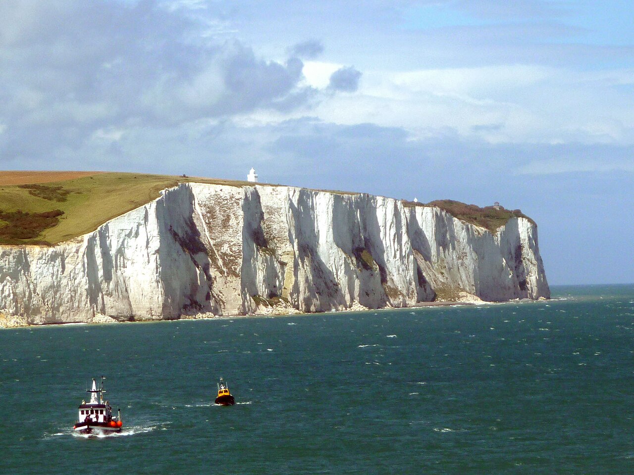
The White Cliffs of Dover are the region of English coastline facing the Strait of Dover and France. The cliff face, which reaches a height of 350 feet (110 m), owes its striking appearance to its composition of chalk accented by streaks of black flint, deposited during the Late Cretaceous. The cliffs, on both sides of the town of Dover in Kent, stretch for eight miles (13 km). The White Cliffs of Dover form part of the North Downs. A section of coastline encompassing the cliffs was purchased by the National Trust in 2016.

Dover Castle is a medieval castle in Dover, Kent, England and is Grade I listed. It was founded in the 11th century and has been described as the "Key to England" due to its defensive significance throughout history. Some writers say it is the largest castle in England, a title also claimed by Windsor Castle.

The Supermarine Spitfire is a British single-seat fighter aircraft used by the Royal Air Force and other Allied countries before, during, and after World War II. It was the only British fighter produced continuously throughout the war. The Spitfire remains popular among enthusiasts. Around 70 remain airworthy, and many more are static exhibits in aviation museums throughout the world.
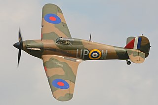
The Hawker Hurricane is a British single-seat fighter aircraft of the 1930s–40s which was designed and predominantly built by Hawker Aircraft Ltd. for service with the Royal Air Force (RAF). It was overshadowed in the public consciousness by the Supermarine Spitfire during the Battle of Britain in 1940, but the Hurricane inflicted 60% of the losses sustained by the Luftwaffe in the campaign, and fought in all the major theatres of the Second World War.
5. Junkers Ju 87 Stuka

The Junkers Ju 87, popularly known as the "Stuka", is a German dive bomber and ground-attack aircraft. Designed by Hermann Pohlmann, it first flew in 1935. The Ju 87 made its combat debut in 1937 with the Luftwaffe's Condor Legion during the Spanish Civil War of 1936–1939 and served the Axis in World War II from beginning to end (1939–1945).
6. Deal Castle

Deal Castle is an artillery fort constructed by Henry VIII in Deal, Kent, between 1539 and 1540. It formed part of the King's Device programme to protect against invasion from France and the Holy Roman Empire, and defended the strategically important Downs anchorage off the English coast. Comprising a keep with six inner and outer bastions, the moated stone castle covered 0.85 acres (0.34 ha) and had sixty-six firing positions for artillery. It cost the Crown a total of £27,092 to build the three castles of Deal, Sandown and Walmer, which lay adjacent to one another along the coast and were connected by earthwork defences. The original invasion threat passed but, during the Second English Civil War of 1648–49, Deal was seized by pro-Royalist insurgents and was only retaken by Parliamentary forces after several months' fighting.
7. Richborough Castle Museum

Richborough Castle is a Roman Saxon Shore fort better known as Richborough Roman Fort. It is situated in Richborough near Sandwich, Kent. Substantial remains of the massive fort walls still stand to a height of several metres.
8. Walmer Castle

Walmer Castle is an artillery fort originally constructed by Henry VIII in Walmer, Kent, between 1539 and 1540. It formed part of the King's Device programme to protect against invasion from France and the Holy Roman Empire, and defended the strategically important Downs anchorage off the English coast. Comprising a keep and four circular bastions, the moated stone castle covered 0.61 acres (0.25 ha) and had 39 firing positions on the upper levels for artillery. It cost the Crown a total of £27,092 to build the three castles of Walmer, Sandown, and Deal, which lay adjacent to one another along the coast and were connected by earthwork defences. The original invasion threat passed, but during the Second English Civil War of 1648–49, Walmer was seized by pro-Royalist insurgents and was only retaken by Parliamentary forces after several months' fighting.
9. North Downs Way inlet

The North Downs Way National Trail is a long-distance path in southern England, opened in 1978. It runs from Farnham to Dover, past Guildford, Dorking, Merstham, Otford and Rochester, along the Surrey Hills Area of Outstanding Natural Beauty (AONB) and Kent Downs AONB.
10. Sandown Castle

Sandown Castle was an artillery fort constructed by Henry VIII in Sandown, Kent, between 1539 and 1540. It formed part of the King's Device programme to protect against invasion from France and the Holy Roman Empire, and defended the strategically important Downs anchorage off the English coast.
11. Time Ball Tower
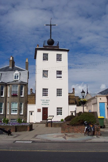
The Deal Timeball is a Victorian maritime Greenwich Mean Time signal located on the roof of a waterfront four-storey tower in the coastal town of Deal, in Kent, England. It was established in 1855 by the Astronomer Royal George Biddell Airy in collaboration with Charles V. Walker, superintendent of telegraphs for the South Eastern Railway Company. It was built by the Lambeth firm of engineers Maudslay and Field. The time ball, which, like the Greenwich time ball, fell at 1 pm precisely, and was triggered by an electric signal directly from the Royal Observatory.
12. St Edmund's Chapel

St Edmund's Chapel is a church in Dover, England, dedicated to St Edmund. It was completed in 1262 as a wayside chapel or chapel of rest for the cemetery for the poor beside the Maison Dieu, just outside the enclosed part of the medieval town, a short distance above Biggin Gate, and for pilgrims setting off for Thomas Becket's shrine at Canterbury Cathedral. This cemetery had been established by the monks of Dover Priory.
13. Shepherdswell (EKR)

Shepherdswell railway station is a station on the East Kent Railway. The southern terminus of the East Kent Light Railway, It opened on 16 October 1916 and closed to passenger traffic after the last train on 30 October 1948. Shepherdswell was the location of the engine shed and works, and many sidings. It served the village of Shepherdswell or Sibertswold.
14. St Mary's Church
St. Mary's Church is a redundant Anglican church in the town of Sandwich, Kent, England. It is recorded in the National Heritage List for England as a designated Grade I listed building, and is under the care of the Churches Conservation Trust. The church is on Strand Street towards the north end of the town.
15. All Saints' Church, Waldershare

All Saints Church is a redundant Anglican church in Waldershare, Kent, England. It is recorded in the National Heritage List for England as a designated Grade II* listed building, and is under the care of the Churches Conservation Trust. The church is located 3 miles (4.8 km) north of Dover on the west side of the A256 road. The North Downs Way passes through the churchyard. The church is notable for the memorials in its chapels.
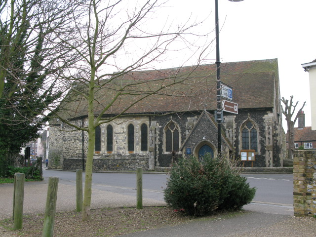
16. St. Mary's

The Church of St Mary the Virgin is a Grade II* listed Anglican church, a parish church in Dover, Kent, and is situated on Cannon Street in the town centre. There was a church on this site in Saxon times. It was largely rebuilt in the 19th century.
Wikipedia: St Mary's Church, Dover (EN), Website, Heritage Website
17. All Saints

All Saints Church, West Stourmouth, is a redundant Anglican church in the civil parish of Stourmouth, Kent, England. It is recorded in the National Heritage List for England as a designated Grade I listed building, and is under the care of the Churches Conservation Trust. The church stands in the settlement of West Stourmouth, some 4 miles (6 km) north of Wingham to the southeast of the A28 road.
18. St. Peters Church

St Peter's Church is a redundant Anglican church in Sandwich, Kent, England. It is recorded in the National Heritage List for England as a designated Grade I listed building, and is under the care of the Churches Conservation Trust.
19. St Peter's Church

St Peter's Church is a redundant Anglican church in the village of Swingfield, some 3 miles (5 km) northeast of Hawkinge, Kent, England. It is recorded in the National Heritage List for England as a designated Grade I listed building, and is under the care of the Churches Conservation Trust.
20. Deal Pier

Deal Pier is the last remaining fully intact leisure pier in Kent. It is the third pier to exist in Deal and was opened in November 1957 by the Duke of Edinburgh. Its structure was extensively refurbished and repaired in 1997, with work including the replacement of much of the concrete cladding on the pier's main piles. Work began in April 2008 to construct a new pier-head with a modern restaurant which opened the same year.
21. South Foreland

South Foreland Lighthouses are a pair of Victorian lighthouses on the South Foreland in St. Margaret's Bay, Dover, Kent, England, used to warn ships approaching the nearby Goodwin Sands. There has been a pair of lighthouses at South Foreland since at least the 1630s. Even after the decommissioning of the Lower Lighthouse the pair continued to be used as leading marks, with Admiralty charts into the 20th century indicating that the 'Lighthouses in line lead south of the Goodwin Sands'.
Share
How likely are you to recommend us?
Disclaimer Please be aware of your surroundings and do not enter private property. We are not liable for any damages that occur during the tours.