86 Sights in Stockholm, Sweden (with Map and Images)

Here you can book tickets, guided tours and other activities in Stockholm:

Tickets and guided tours on Viator*

Here you can book free guided walking tours in Stockholm:

Guided Free Walking Tours on GuruWalk*

Explore interesting sights in Stockholm, Sweden. Click on a marker on the map to view details about it. Underneath is an overview of the sights with images. A total of 86 sights are available in Stockholm, Sweden.

List of cities in SwedenSightseeing Tours in Stockholm

1. Fotografiska

Show sight on mapBook Ticket*

Fotografiska is a centre for contemporary photography in the Södermalm district of Stockholm, Sweden that was founded by brothers Jan and Per Broman and opened on 21 May 2010. In March 2021, it merged with NeueHouse and is operated by Yoram Roth and Josh Wyatt under the parent company CultureWorks.

Wikipedia: Fotografiska (EN), Website

2. Gamla stan

Show sight on map

Gamla stan, until 1980 officially Staden mellan broarna, is the old town of Stockholm, Sweden. Gamla stan consists primarily of the island Stadsholmen. Officially, but not colloquially, Gamla stan includes the surrounding islets Riddarholmen, Helgeandsholmen and Strömsborg. It has a population of approximately 3,000.

Wikipedia: Gamla stan (EN)

3. Mårten Trotzigs Gränd

Show sight on map

Mårten Trotzigs gränd is an alley in Gamla stan, the old town of Stockholm, Sweden. Leading from Västerlånggatan and Järntorget up to Prästgatan and Tyska Stallplan, the width of its 37 steps tapers down to a mere 90 centimetres (35 in), making the alley the narrowest street in Stockholm.

Wikipedia: Mårten Trotzigs Gränd (EN)

4. Bonde Palace

Show sight on map

The Bonde Palace is a palace in Gamla stan, the old town in central Stockholm, Sweden. Located between the House of Knights (Riddarhuset) and the Chancellery House (Kanslihuset), it is, arguably, the most prominent monument of the era of the Swedish Empire (1611–1718), originally designed by Nicodemus Tessin the Elder and Jean De la Vallée in 1662-1667 as the private residence of the Lord High Treasurer Gustaf Bonde (1620–1667) it still bears his name, while it accommodated the Stockholm Court House from the 18th century and since 1949 houses the Swedish Supreme Court. On the south side of the building is the street Myntgatan and the square Riddarhustorget, while the alleys Riddarhusgränd and Rådhusgränd are passing on its western and eastern sides.

Wikipedia: Bonde Palace (EN), Heritage Website

5. Skanskvarns luftvärnsställning

Show sight on map

The hilted knife air gun seat in the log is located in the annual city center about 400 meters north of the Litter Highway, to the west of the Litter Highway and above the Colonial Complex Cabin. The facility consists of shooting guns and rifles and tank barriers. The factory was in a "state of tension" during the emergency period from 1939 to 1945. The main task of the skan mill air gun rack is to defend the skan bridge and the skan road bridge, as well as the annual bridge of the important railway connection. If the defenses have collapsed, the idea is to blow up the bridge before the enemy can use it. Today (2011), two obvious shackles remain, and the rest have been removed or re-laid. The name comes from nearby skvarn.

Wikipedia: Skanskvarns luftvärnsställning (SV)

6. Dianafontänen I

Show sight on map

The Diana fountain, or Dianabrunnen, is a sculpture in bronze and marble by Carl Milles. The Diana fountain is available in two designs, the Diana fountain was created in 1927–1928 and is located in the Match Palace's farm in Stockholm, Dianafontänen II was created in 1929–1930 and is available as a copy of Skytteholm, Ekerö municipality. In the Tomelilla square stands a Diana fountain that was donated by Milles to the resort when he was told that the resort intended to call a street after him as memory after the Tomelilla exhibition in 1927. In Tomelilla, the sculpture is called Artemis after Diana's Greek counterpart. "Diana" also exists as a sole figure in bronze, equipped with a skirt.

Wikipedia: Dianafontänen (SV)

7. Betlehemskyrkan

Show sight on map
Betlehemskyrkan

Bethlehem Church is the Swedish Evangelical Mission's church in Stockholm, Sweden. The old church building was consecrated in October 1840 as Sweden's first free church building, under the name Engelska kapellet. It was located near Hötorget in Norrmalm, where the second and third Hötorget buildings are now located and was taken over by the Swedish Evangelical Mission in connection with the founding of the organization in 1856. The church was demolished in 1953 in conjunction with the redevelopment of Norrmalm. The new church was consecrated in 1956 at Luntmakargatan in Vasastan.

Wikipedia: Bethlehem Church (Stockholm) (EN), Website

8. Karl Staaffs Park

Show sight on map

Karl Staaffs Park is a park on Norrmalm in central Stockholm located at the intersection of Birger Jarlsgatan and Regeringsgatan. The place where the square and Eriksbergsplan on the other side of Birger Jarlsgatan are located was formerly known as Träsktorget where the pillory for public punishment was for a time placed. The small park was originally named Spårvägsparken after a kiosk for tram staff located on the site and AB Stockholms Spårvägar's head office nearby. A smaller building designed by Nils Cronholm housed from 1912 John A. Bergendahl's cinema Birger Jarl.

Wikipedia: Karl Staaffs park (SV)

9. Kronprinsesse Märthas kirke

Show sight on map

Kronprinsesse Märthas kirke is a church building in the Stammen block on Stigbergsgatan on Södermalm in Stockholm, Sweden. It is run by Sjømannskirken, the Church of Norway's foreign ministry, and is named after Crown Princess Märtha of Norway. The entrance is from Stigbergsgatan 24, but the building is also visible far above Renstiernas gata which is below. The building is bruised by the City Museum in Stockholm, which means "that the buildings are judged to have particularly high cultural-historical values".

Wikipedia: Kronprinsesse Märthas kirke (SV)

10. Katarina Elevator

Show sight on map

The Katarina Elevator or Katarina Lift is a passenger elevator in Stockholm that connects Slussen to the heights of Södermalm. The lift was a shortcut between Katarinavägen, Slussen and Mosebacke torg. The original lift was constructed in 1881, but the current structure dates from the rebuilding of the Slussen transport interchange in 1936. The lift has been closed since 2010 due to lack of security in the construction. The lift will remain closed at least until Projekt Slussen is completed in 2025.

Wikipedia: Katarina Elevator (EN)

11. Maskinparken

Show sight on map

Robot Park is a park in the Royal Engineering College Park of the Northern Zoo in Stockholm. The park is located between Christian Queen's Road in the southwest and Bronze Road in the northeast. The park separates the northernmost part of Election Hall Road, where the Dance Academy and Department of Mechanical Engineering are located, from the rest of the campus. Across the park, a path from Queen Yakina goes east through the burning path, and further towards the owl path at the owl source.

Wikipedia: Maskinparken (SV)

12. La Mano

Show sight on map
La Mano

La Mano is a memorial in Stockholm in memory of the Swedes who died during the Spanish Civil War, most of whom fought in the Thälmann Battalion. It stands next to Katarinavägen on Södermalm. The monument was created by Liss Eriksson and made by him together with Göran Lange and was completed in 1977. Göran Lange has also made the map of Spain in stone that is on the ground next to the statue. On it are the main blows engraved, and they are mentioned in the quote on the plinth:

Wikipedia: La Mano (SV)

13. Gustaf Vasa Church

Show sight on map

Gustaf Vasa Church is a church located in the Vasastaden district of Stockholm, Sweden. Inaugurated in 1906 and named after 16th century King Gustav Vasa, it was designed by architect Agi Lindegren in the Baroque Revival style. Situated between two busy avenues partially lined with trees, its dome rises 60 metres (200 ft) above the nearby Odenplan plaza. The floor plan is in the shape of a Greek cross and seats 1,200 people, making it one of the largest churches in Stockholm.

Wikipedia: Gustaf Vasa Church (EN), Heritage Website

14. Ekermanska malmgården

Show sight on map
Ekermanska malmgården

Yekman Mountain Ore Field is a property located in the south mine of Log Cave. The ore yard is located at the Block Enter River Farm between the Beltway, Enter River Alley and the Southern Down Road. Today, the ore yard is the hometown farm of the High Fat Hometown Association. This building is rated blue by stockholm's City Museum, which means that the building has "extremely high cultural and historical value", which is equivalent to the requirements of architectural memory.

Wikipedia: Ekermanska malmgården (SV)

15. Stockholm Transport Museum

Show sight on map

The Spårvägsmuseet, or Tramway Museum, was located at Tegelviksgatan 22 in Södermalm, Stockholm, Sweden. It was owned and operated by Storstockholms Lokaltrafik, and shows the development of public transportation in the Stockholm area from the 1650s until today. The Museum's mission also covers contemporary and future public transport in the Stockholm region, and water transportation in the area. The museum also houses a library, an archive and a café.

Wikipedia: Spårvägsmuseet (EN), Website

16. Bacchus 6

Show sight on map
Bacchus 6

The Bacchus block is a block in Stockholm's Old Town. The block is surrounded by Österlånggatan in the west, Brunnsgränd in the north, Skeppsbron in the east and Skottgränd in the south. The area for today's Bacchus block came into being after the 1640s when the Eastern City Wall was demolished and new buildable land was built on partially filled land along Skeppsbron. North of the block in today's Diana block was the medieval Fisherman's Square.

Wikipedia: Kvarteret Bacchus (SV), Heritage Website

17. Balders Hage

Show sight on map

Balder's Hare is in the park of the bog town on the east ore of the log inner city. The park is part of a city plan for a new villa city proposed by architect per-olofHallman in 1902. The hall was influenced by Austrian architect Camilo, who thought about the construction of art city. The building will adapt to the formation of terrain, smaller than the traditional one, with quiet streets, terraces, little squares and parks. The park was named 1925.

Wikipedia: Balders hage, Stockholm (SV)

18. Eriksbergsparken

Show sight on map

Toyama Park is the East Mineral Park in the Furixberg Informal Zone in the inner city of Stoke Holmes. The park was placed in 1920 under the master of city gardening, Moritz Hammarberg, and is adjacent to the site of the mountain, the former swamp square. The park is designed as a staircase, which is a terrace with plantations and fountains. Above the park, wood word order has its buildings. On the other side of Birdsong Street is Karl Stave's Park.

Wikipedia: Eriksbergsparken, Stockholm (SV)

19. Engelska parken

Show sight on map

Engelska parken on Norra Djurgården is one of Stockholm's most hidden parks. It is located behind the Royal Institute of Technology's largest lecture hall F1 (Alfvénsalen) on a terrace above the adjacent Lill-Jansskogen. The park is accessed from the south via a hole in the wall from Lindstedtsvägen, from the north via a terrace behind the building at Teknikringen 24, or from the west via a staircase from the open space Övre borggården.

Wikipedia: Engelska parken, Norra Djurgården (SV)

20. Väskberget i Hammarbyhöjden

Show sight on map

Kvartert Taklampan is a block at Finn Malmgrens väg 87 and 89 and 116 and 118 in Björkhagen in Stockholm. The block is surrounded by Finn Malmgrens väg in the west, Nackareservatet in the east, Karlsborgsvägen in the south and Hammarbybacken in the northwest. The block consists of one property: Taklampan 1 and is one of ten new construction projects in Stockholm Municipality that were nominated for Stockholm Building of the Year 2018.

Wikipedia: Kvarteret Taklampan (SV)

21. Sätra vattentorn

Show sight on map

Seated water tower is a seated water reservoir located in the south round hole. Because of its high location, the water tower is located throughout the Southwest Log and is a landmark that can be seen up to Oak Island. The water tower is located in the aquatic grass forest nature reserve. The building is poorly blown by the City Museum in Stoke, meaning "the building is considered of extremely high cultural and historical value".

Wikipedia: Sätra vattentorn (SV)

22. Gröndals kyrka

Show sight on map

The Hulk's Church is the church within the Hare Parish in a log pin. The building is made of red-brown bricks and is located in the middle of Green Valley. The address is 61 Green Valley Road and Jiaoyedong Road. The building is marked by stockholm's City Museum, which means that "the building is of high cultural and historical value, especially from a historical, cultural, environmental or artistic point of view".

Wikipedia: Gröndals kyrka (SV)

23. Eriksdalslunden

Show sight on map

Fu Gu Lin is a park facility and colonial garden located on the South Ore in the inner city of Stockholm. The park is located between Ricksdale Sbad and the ring city, and the colonial area extends from Ricksdale Sbad in the east along the annual bay to the southern Hills Strait colonial area in the west. In the colonies of the region, there is also a bivalve shellfish located at the Stockholm exhibition in 1897.

Wikipedia: Eriksdalslunden (SV)

24. Flygarmonumentet

Show sight on map

The Aviator Monument is a statue that stands at Karlaplan in central Stockholm, Sweden. The statue was a gift from the Swedish Aeronautical Society in memory of different Swedish aviation pioneers who fell in both the North Pole expedition of 1898 and in the Swedish aviator era in 1917. The task to build the monument was given to the famous sculptor Carl Milles. The Aviator Monument was finished in 1931.

Wikipedia: Aviator Monument (Stockholm) (EN)

25. Gamla Auktionsverket

Show sight on map

Gamla Auktionsverket is four houses built together on Riddarholmen in central Stockholm. The oldest building dates from the 1750s. The Old Auction House is located on the waterfront in the western part of the island between Birger Jarl's tower and wrangelska palace, below Schering Rosenhane's palace. The property is currently (2015) occupied by the Svea Court of Appeal and the Chancellor of Justice.

Wikipedia: Gamla Auktionsverket (SV), Heritage Website

26. Engelbrekt Church

Show sight on map
Engelbrekt Church Bengt A Lundberg / CC BY 2.5

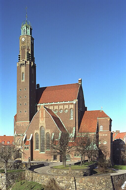
Engelbrekt Church is a protected church located in the Lärkstaden area of Stockholm, Sweden. Its located at Östermalm and belongs to the Church of Sweden and is parish church for Engelbrekt Parish in the Diocese of Stockholm. It was designed by architect Lars Israel Wahlman in the National Romantic style and completed in 1914. It is one of the largest churches in Stockholm, with 1,400 seats.

Wikipedia: Engelbrekt Church (EN), Heritage Website

27. Intiman

Show sight on map

Intiman, formerly Wallmans Intiman, is a private theatre located at Odenplan in Stockholm. The theatre was opened in 1950 by Lorens Marmstedt and Alf Jörgensen and was taken over by Sandrews in 1966. In 1997, Hasse Wallman became theatre director for Intiman, and the theatre was named Wallmans Intiman. In 2010, the Wallmans Group was bought by 2Entertain, which reinstated the original name.

Wikipedia: Intiman (SV)

28. Karl XIII

Show sight on map
Karl XIII

In the Royal Garden in Stockholm, it stands a statue of Carl Shea. Completed by the wealthy Gustav vulture, it was erected on November 5, 1821 as a monument to King Carl xiii. It was increased by Inzraf John and his fees. He was an adopted child, and it was on the anniversary of the adoption that the statue was unveiled. The statue is administered by the government's Real Estate Authority.

Wikipedia: Karl XIII:s staty (SV)

29. Kolerakyrkogården

Show sight on map

The cholera cemetery was a cholera cemetery near Skanstull in Stockholm that was used during the years 1809 to 1901. Many victims from Stockholm's two cholera epidemics in 1834 and 1853 were buried here – hence the name. The cholera cemetery is now one of Stockholm's parks along Olaus Magnus väg and the street Hammarbybacken with a location east of Gullmarsplan in Johanneshov.

Wikipedia: Kolerakyrkogården, Skanstull (SV)

30. Sofia kyrka

Show sight on map

Sofia Church, named after the Swedish queen Sophia of Nassau, is one of the major churches in Stockholm, Sweden. It was designed during an architectural contest in 1899 and was inaugurated in 1906. It is located in the eastern part of the island of Södermalm, standing on the north east peak of the Vita Bergen park. Sofia church belongs to Sofia parish of the Church of Sweden.

Wikipedia: Sofia Church (EN), Heritage Website

31. Sankt Eriksparken

Show sight on map

Sankt Eriksparken was a park at Kvarteret Flygmaskinen in the Vasastaden district of Stockholm and adjacent to the Sländan block. The park was located between Norra Stationsgatan in the north, Dannemoragatan in the east, Sankt Eriksgatan in the west and Upplandsgatan / Västmannagatan in the south. At Sankt Eriksparken's site is now an extension of Rödabergsskolan.

Wikipedia: Sankt Eriksparken (SV)

32. Citykyrkan

Show sight on map

Citykyrkan is a Pentecostal congregation on Adolf Fredriks kyrkogata 10 in Stockholm, a few blocks from Hötorget. The parish was founded in 1936 as Östermalms Fria Församling. It was for a period affiliated with the Philadelphia Congregation. The building, which the congregation purchased in 1940, is an old entertainment venue formerly known as the Phoenix Palace.

Wikipedia: Citykyrkan, Stockholm (SV)

33. Fåfängan

Show sight on map

Vanity is a viewpoint with a restaurant and café located on the mountain near Danviken as far east as you can get on Södermalm in Stockholm. With its tree framing of chastened linden trees, which are visible from afar, it is a characteristic feature of Stockholm's urban landscape. When the restaurant is open, the four flags are hoisted at the top of the mountain.

Wikipedia: Fåfängan (SV)

34. Willy Brandts park

Show sight on map
Willy Brandts park

Willy Brandts Park is a small park in Hammarbyhöjden, Stockholm. It is named after former German Chancellor Willy Brandt, who lived in the area in the 1940s during his exile from Nazi Germany. The park got its current name in 1997. A sculpture by German artist Rainer Fetting depicting Willy Brandt has been erected in the park and was unveiled on June 14, 2007.

Wikipedia: Willy Brandts Park (EN)

35. Stockholm Mosque

Show sight on map
Stockholm Mosque

Zayed bin Sultan Al Nahyan's Mosque, commonly known as the Stockholm Mosque or the Stockholm Grand Mosque, is the largest mosque in Stockholm, Sweden. It is located at Kapellgränd 10, adjacent to the small park Björns trädgård, in the Södermalm district of Stockholm. Inaugurated in 2000, the mosque is administered by the Islamic Association in Stockholm.

Wikipedia: Stockholm Mosque (EN)

36. Skansen allotments

Show sight on map

Skansen's colonial garden is a colonial garden located at Skansen in Stockholm. The colonial garden consists of two tickets with each of its time -typical cottage. The colony was built in 1997 at the outer edge of Skansen's city block. The situation symbolizes the historical location of Sweden's colonial gardens in the areas between city and country.

Wikipedia: Skansens koloniträdgård (SV), Website

37. Stora Blecktornsparken

Show sight on map

Stora Blecktornsparken is a park at Södermalm in central Stockholm. It is located south of Lilla Blecktornsparken and is bounded in the west by canal planes and in the east of the Winter Customs Square. The park has its name after Malmgården Stora Blecktornet, which is located in the western part of the park. The park is commonly called "big tin".

Wikipedia: Stora Blecktornsparken (SV)

38. Filadelfiakyrkan

Show sight on map

Filadelfiakyrkan is a Pentecostal church building at Rörstrandsgatan 7 in Stockholm, Sweden; it was dedicated on 2 November 1930. The building is owned by the Filadelfia Stockholm congregation, the largest congregation in the Swedish Pentecostal movement with about 5,400 members as of 2015. It is also the largest Pentecostal congregation in Europe.

Wikipedia: Filadelfiakyrkan (EN)

39. Strindberg Museum

Show sight on map

The Strindberg Museum is a museum in Stockholm, Sweden. It is dedicated to the writer August Strindberg (1849-1912) and located in his last dwelling. The site is in the building he nicknamed "Blå tornet" at Drottninggatan 85 on the corner of Drottninggatan and Tegnérgatan in the borough of Norrmalm in central Stockholm.

Wikipedia: Strindberg Museum (EN), Website

40. Observatory Museum

Show sight on map

The Stockholm Observatory is an astronomical observatory and institution in Stockholm, Sweden, founded in the 18th century and today part of Stockholm University. In 1931, the new Stockholm Observatory, nicknamed "Saltis", was inaugurated on the Karlsbaderberget at Saltsjöbaden, near Stockholm, and operated until 2001.

Wikipedia: Stockholm Observatory (EN)

41. Katarina kyrka

Show sight on map

Katarina kyrka is one of the major churches in central Stockholm, Sweden. The original building was constructed 1656–1695. It has been rebuilt twice after being destroyed by fires, the second time during the 1990s. The Katarina-Sofia borough is named after Katarina Parish and the neighbouring parish of Sofia.

Wikipedia: Katarina Church (EN), Heritage Website

42. Gustav Adolfs kyrka

Show sight on map

Gustaf Adolfskyrkan is a church located in the northern part of Gustaf Adolfsparken, on Östermalm in Stockholm. The church, designed by Carl Möller, was consecrated in 1892 by Bishop Gottfrid Billing. as a garrison church for Svea livgarde but now belongs to the Church of Sweden through Oscar's congregation.

Wikipedia: Gustav Adolfskyrkan (SV)

43. Gotlandsparken

Show sight on map

Gotland Park is a park located on the south ore of Log Cave. It is like a string between the monument and the obelisk, surrounded by Gotland Street, which is designed as a turning ring here. The park is rather unattractive, with a playground and several park benches. It was demolished by 2000 at the latest.

Wikipedia: Gotlandsparken (SV)

44. Ölands windmill

Show sight on map

Skansen's mills consist of three windmills and a squall mill that can be found at the open-air museum Skansen in Stockholm. These are two post mills from Torslunda and Forgetinge parishes, western Öland, a holk mill from Främmestad parish in Västergötland and a squall mill from Viske härad in Halland.

Wikipedia: Skansens kvarnar (SV)

45. Colour Factory

Show sight on map

Färgfabriken is an art gallery for contemporary art, architecture, social issues and urban development. Konsthallen is located on Lövholmen, a former industrial area in Liljeholmen, Stockholm Municipality. Until the 1970s, the premises housed the paint manufacturer Beckers, hence the name Färgfabriken.

Wikipedia: Färgfabriken (SV), Website

46. De fyra elementen

Show sight on map

The Four Elements is a monumental mobile sculpture created by the American sculptor Alexander Calder in 1961. The sculpture is a motorized moving group of four metal sheets. The artwork is about 30 feet high. The sheets are painted in plain colours. This sculpture is made after a Calder model from 1938.

Wikipedia: The Four Elements (sculpture) (EN)

47. Kyrkan vid Brommaplan

Show sight on map

The bridge deck church is the church building of the Bromma Baptist congregation. The church is located at 400 Queen's Hall, on Bridge Marnsloan Square, in the western part of Stolom County. The assembly was founded in 1949 and then belonged to the 2011 equmeniakran, the former Swedish Baptist Society.

Wikipedia: Kyrkan vid Brommaplan (SV)

48. Bergianska trädgården

Show sight on map

The Bergianska trädgården, the Bergian Garden or Hortus Bergianus, is a botanical garden located in the Frescati area on the outskirts of Stockholm, close to the Swedish Museum of Natural History and the main campus of Stockholm University. The director of the garden is known as Professor Bergianus.

Wikipedia: Bergianska trädgården (EN), Website

49. Sankt Matteus kyrka

Show sight on map

St Matthew's Church is the parish church of St Matthew's Church, the pin in Stoke Holmes. Located in the vase intercalation of the central log. The church was built between 1901 and 03 at the intersection of the Wanadis Highway and Dharagata as a chapel for what was then the Adolf Pacifist Congress.

Wikipedia: S:t Matteus kyrka (SV)

50. National Library of Sweden

Show sight on map
National Library of Sweden Kungliga biblioteket (Designed by Lars Laurentii) / CC BY-SA 2.5

The National Library of Sweden is Sweden's national library. It collects and preserves all domestic printed and audio-visual materials in Swedish, as well as content with Swedish association published abroad. Being a research library, it also has major collections of literature in other languages.

Wikipedia: National Library of Sweden (EN), Website, Heritage Website

51. Stefanskyrkan

Show sight on map

St. Stephen's Church or St. Stephen's Church is a church building in St. John's Parish that is part of the Cathedral Contract of the Diocese of Stockholm. The church was built in 1904 and is located at Frejgatan 20B at the southern end of Vanadislunden in Vasastaden in Stockholm's inner city.

Wikipedia: Stefanskyrkan, Stockholm (SV)

52. Kammarrättens hus

Show sight on map

The Chamber of Commerce House is a neoclassical style building in Bird Jargon 13 of the Square 13 in the Log of the Knight Cave. In 1804, the building was built at the stockholm after the Knight Fire of 1802 and is located at the site of the former House of Commons, the burnt Prussian palace.

Wikipedia: Kammarrättens hus (SV), Heritage Website

53. Carl Eldh Studio Museum

Show sight on map

The carl Fire Athletes Museum is an artist's museum on Happy Valley Avenue at 10 Bagpipe Park in the town of Log's Vase. The museum is an athlete of sculptor Carl Vulcan. Athens bathroom is saved as carl fire, once it is left. The facility has been a memory of government buildings since 2010.

Wikipedia: Carl Eldhs Ateljémuseum (SV), Website

54. Åkeshovs slott

Show sight on map

Åkeshov Palace is located in Bromma, a borough of Stockholm, Sweden. Historically, Åkeshov was situated in Bromma socken, which was incorporated with the City of Stockholm in 1916. After having undergone a careful reconstruction, the palace is used today as a hotel and conference facility.

Wikipedia: Åkeshov Palace (EN), Website

55. Royal Mews

Show sight on map

The hoof stall is called h.m.. The King's Hoof Stables Building, located at Block Cube at 1 Arms Street and 22 Knight Street, adjoins the Royal Theatre on East Ore at Stockholm. This building was completed by King Oscar ii in 1894. The Royal Hoof Stall is a memory of government buildings.

Wikipedia: Hovstallet, Väpnargatan (SV), Website

56. Norrmalmskyrkan

Show sight on map

Norrmalmskyrkan in Vasastaden in Stockholm, with address Norrtullsgatan 37, is norrmalms baptist congregation's church. The congregation belongs to equmenia church. The congregation welcomes everyone, regardless of faith, to its worship services and other public gatherings and activities.

Wikipedia: Norrmalmskyrkan (SV)

57. Folkoperan

Show sight on map
Folkoperan

Folkoperan is an opera house in Stockholm, Sweden, at Hornsgatan 72 in the southern district of Södermalm. It is one of Stockholm's most successful opera houses in terms of audience attendance, and is considered Sweden's most important stage for freelance opera singers and musicians.

Wikipedia: Folkoperan (EN), Website

58. Sankta Birgitta Kyrka

Show sight on map

Sankta Birgitta Church is a church building in Nockeby. It belongs to Västerled Parish in the Diocese of Stockholm. The church is located about a hundred meters from the Nockeby line's terminus now Nockeby. Where the church is located, there used to be a turning loop for the trams.

Wikipedia: Sankta Birgitta kyrka, Stockholm (SV)

59. Frälsningsarméns tempel

Show sight on map

The temple is the salvation army's first corps (congregation) on Östermalmsgatan 69, on Östermalm in Stockholm. It was built in 1886–1887 as the first union room in Sweden, for Stockholm's 1st corps and is today the oldest union building in the world in continued continuous use.

Wikipedia: Templet, Stockholm (SV)

60. Ellen Keys Park

Show sight on map

This park is a park, near the jargon board on the east ore of the inner city of Stockholm. The park, which covers an area of 0.5 hectares, is located between Kara Road and Birdsong Street and is confined to the north by the new residential area and the south of bourgeois schools.

Wikipedia: Ellen Keys park (SV)

61. Droskan

Show sight on map

Droskan is a park located on the corner of Folkungagatan/Södermannagatan on Södermalm in central Stockholm. The park is the continuation of the Drosk horse neighborhood and the park name connects to the use of the word droska in the sense of "horse-drawn" and later "taxi".

Wikipedia: Droskan (SV)

62. Anna Lindhs Park

Show sight on map

Anna Linders Park, a former Winter Toll Park, is a park in the north of Hammer Harbor in the south of Wooden Cave Ore. Surrounding the park is the Harbor Guard Area, the first new residential block built on Hammer Pier; In the south, the park faces the pier and Hammer Lake.

Wikipedia: Anna Lindhs park, Stockholm (SV)

63. Bergsgruvan

Show sight on map

Mountain Mine is located in the south station area of Log Cave South Mine. Mountain Mine, on the one hand, is the mountain area north of South Station, on the other hand, it is the name of the park located there. Rose Garden Street, which borders the park to the west.

Wikipedia: Bergsgruvan (SV)

64. Rosenlundsparken

Show sight on map

Rosenlundsparken is a park at Södermalm in Stockholm. The park also called the "Skåne Lighten" began to be built in the 1930s and ended only in the early 1970s. For the renovation conducted in 2007, the park section "The beach" was awarded the Siena Prize in 2008.

Wikipedia: Rosenlundsparken (SV)

65. Sjöstadskapellet

Show sight on map
Sjöstadskapellet

Sjöstadskapellet is a chapel belonging to Sofia Parish in the Diocese of Stockholm. The chapel is located at Tvärbanan's station Sickla kaj in the district Södra Hammarbyhamnen in Stockholm. On December 4, 2002, the chapel was dedicated by Bishop Caroline Krook.

Wikipedia: Sjöstadskapellet (SV)

66. Humlegården

Show sight on map

Humlegården is a major park in the district of Östermalm in Stockholm, Sweden. The park borders on Karlavägen in the north, Sturegatan in the east, Humlegårdsgatan in the south and Engelbrektsgatan in the west. It is the location of the Swedish Royal Library.

Wikipedia: Humlegården (EN)

67. Skansen

Show sight on map
Skansen

Skansen is the oldest open-air museum and zoo in Sweden located on the island Djurgården in Stockholm, Sweden. It was opened on 11 October 1891 by Artur Hazelius (1833–1901) to show the way of life in the different parts of Sweden before the industrial era.

Wikipedia: Skansen (EN), Website

68. Saint Eric's Cathedral

Show sight on map

Sankt Erik's Catholic Cathedral, also known as Stockholm's Catholic Cathedral, located in the Nattugglan block at Folkungagatan 46 on Södermalm in Stockholm, is the cathedral of Stockholm's Catholic diocese and thus the entire Roman Catholic Sweden.

Wikipedia: Stockholms katolska domkyrka (SV), Website

69. Birger Jarl

Show sight on map

Birger jarl's statue is a statue depicting the Earl of Sweden and regent Birger jarl. The statue stands on Birger jarls torg on Riddarholmen in Stockholm. The statue was created by sculptor Bengt Erland Fogelberg and unveiled on October 21, 1854.

Wikipedia: Birger jarl (staty) (SV)

70. Linnémonumentet

Show sight on map

Linnaeus Monument is a group of statues in a beer garden in the inner city of Stockholm, imagining carl von linne. It was performed by Free Skirt Mountain and unveiled in 1885. Around the monument, there are 21,000 plants on the flax plantation.

Wikipedia: Linnémonumentet (SV)

71. Skyview

Show sight on map

Avicii Arena, originally known as Stockholm Globe Arena and previously as Ericsson Globe, but commonly referred to in Swedish simply as Globen, is an indoor arena located in Stockholm Globe City, Johanneshov district of Stockholm, Sweden.

Wikipedia: Skyview (Ericsson Globe) (EN)

72. Centralbadsparken

Show sight on map

Central Bath is one of the parks with the smallest logs, located in the northern ore block in the original wooden barrel. The block is bounded by Queen Street, Adolf Peace Kingdom Church Street, Holland Street and Lorf Palm Tree Street.

Wikipedia: Centralbadsparken (SV)

73. Dårarnas båt

Show sight on map

The Boat of the Fools is a sculpture created by Sture Collin in 1990. The sculpture is located in three locations around Sweden: T-banestation Sockenplan in Stockholm, Hornsgatspuckeln, also in Stockholm and in Vasaparken in Västerås.

Wikipedia: Dårarnas båt (SV)

74. Seglora Church

Show sight on map

Seglora Church is a wooden church building located at Skansen in Stockholm. It was erected in 1729 in Seglora in Västergötland, but was moved in 1918 to Skansen, after a new parish church in stone made the older church redundant.

Wikipedia: Seglora kyrka (SV), Website

75. Finnish Church

Show sight on map
Finnish Church

The Finnish Church is a church building in Gamla stan in Stockholm, Sweden. Belonging to the Stockholm Finnish Parish of the Church of Sweden, it was opened in 1725 after the Lilla Bollhuset building had been rebuilt into a church.

Wikipedia: Finnish Church, Stockholm (EN), Website, Heritage Website

76. Kristi förklarings ortodoxa kyrka

Show sight on map

The Christian Orthodox Church is the church and parish on Bird Jargon Street at 98 in the eastern ore district of the inner city of Stockholm. Church rooms built between 1905 and 1907 were declared architectural monuments in 1999.

Wikipedia: Kristi förklarings ortodoxa kyrka (SV)

77. Vanadislundens vattenreservoar

Show sight on map

Vanadislunden water reservoir or Vanadislundsreservoaren is a large water reservoir within Vanadislunden in the Vasastaden district of Stockholm. The Vanadislund reservoir today (2009) has a water volume of 8,100 m³.

Wikipedia: Vanadislundens vattenreservoar (SV)

78. Jewish Museum

Show sight on map

The Jewish Museum in Stockholm is a museum located on Själagårdsgatan 19 in the Cupido neighborhood in the Old Town where it reopened on June 6, 2019. The museum is housed in Stockholm's oldest preserved synagogue.

Wikipedia: Judiska museet (SV), Website

79. Vi ses vid målet

Show sight on map
Vi ses vid målet

See you at the goal is a sculpture in memory of football legend Lennart "Nacka" Skoglund and is located in Nacka's corner at the intersection Brännarigatan - Katarina Bangata at Södermalm in Stockholm's inner city.

Wikipedia: Vi ses vid målet (SV)

80. Tessinparken

Show sight on map

Tessinparken is a park on Gärdet in Stockholm, Sweden. The park is T-shaped and starts in the south at Valhallavägen and extends to Askrikegatan in the north. It is located within the Royal National City Park.

Wikipedia: Tessinparken (SV)

81. Birger Jarlspassagen

Show sight on map

Birger Jarlspassagen is Stockholm's smallest and oldest mall that stretches in the Rännilen block diagonally from Smålandsgatan 10 to Birger Jarlsgatan 9. The passage was inaugurated in 1897 by King Oscar II.

Wikipedia: Birger Jarlspassagen (SV)

82. Olaus Petri kyrka

Show sight on map

Olaus Petri Church is a church building in Oscar's parish. It is located on Armfeltsgatan 2 in the district of Ladugårdsgärdet, Stockholm. The architect is Peter Celsing. The church was consecrated in 1959.

Wikipedia: Olaus Petri kyrka, Stockholm (SV)

83. Anna Sterkys minne

Show sight on map

Anna Sterky's memory is a sculpture on Norra Bantorget in Stockholm. The double-sided bronze relief in memory of Anna Sterky was erected in 1988 and was executed by sculptor Christina Rundqvist Andersson.

Wikipedia: Anna Sterkys minne (SV)

84. Sveaplan

Show sight on map

Sveaplan is a circulation site at the northern end of Sveavägen in the district of Vasastaden in Stockholm's inner city. At Sveaplan, Sveavägen's southern and east-west parts and Cedersdalsgatan meet.

Wikipedia: Sveaplan, Stockholm (SV)

85. Andreaskyrkan

Show sight on map

Andreaskyrkan is a free church located in the Pelarbacken block at Högbergsgatan 31 on Södermalm in Stockholm. Andreaskyrkan belongs to Equmeniakyrkan, a community with about 65,000 members in Sweden.

Wikipedia: Andreaskyrkan, Stockholm (SV)

86. Stigbergsparken

Show sight on map

Stigbergsparken is located on the north side of Folkungagatan on Södermalm in Stockholm. The park received its current name in 1919. In the area, Stigbergsparken also goes by the name Folkungaparken.

Wikipedia: Stigbergsparken (SV)

Share

Spread the word! Share this page with your friends and family.

Disclaimer Please be aware of your surroundings and do not enter private property. We are not liable for any damages that occur during the tours.